Étiquette : Palestine
Le Plan Oasis, socle d’un Etat palestinien et source de paix pour la région

Dossier élaboré par Karel Vereycken à partir des propositions et recherches effectuées par les membres et collaborateurs de l’Institut Schiller à l’échelle internationale.

L’eau au Moyen-Orient, casus belli permanent ou pierre angulaire d’une paix durable?


Le 28 mars 2025, Karel Vereycken, pour l’Institut Schiller, lors d’un colloque organisé par l’Académie de géopolitique de Paris sur l’avenir de la Palestine, retrace les enjeux de l’eau au Proche orient, casus belli permanent ou pierre angulaire d’une paix durable.
Dans ce cadre, il présente le Plan Oasis, vaste programme de développement des infrastructures de base (eau, énergie, transports, etc.) promu par l’Institut Schiller.
TRANSCRIPTION:
L’eau au Proche-Orient, casus belli permanent ou pierre angulaire d’une paix durable ?
M. le Président, Excellences, chers amis, d’abord merci pour cette invitation. Je suis assez d’accord avec l’orateur précédent [le Pr Strauss.1], qui dit que c’est très important de regarder certains aspects « purement pratiques » avant de bâtir de grandes théories, parce que commencer à résoudre ces aspects pratiques peut être le début d’un processus pouvant finalement conduire à la paix.
Parmi ces sujets, l’eau, évidemment, la question fondamentale dont je vais essayer de vous parler. En réalité la question n’est pas « l’eau », mais plutôt « l’accès à l’eau douce ».
L’Asie du Sud-Est, il faut d’abord le rappeler, est une région essentiellement semi-aride. Il existe bien sûr « le croissant fertile », comprenant l’Irak, la Syrie et le Liban. Mais pour la Jordanie, peut-être encore plus que pour toute la Palestine et Israël, le problème de l’eau et de l’accès à l’eau reste une question fondamentale, voire une question de sécurité nationale, avec ce que cela comporte de bon et également de terrible. Parce qu’au nom de la « sécurité nationale », on peut appliquer des pouvoirs d’exception.
Or, l’eau ne respecte pas les frontières tracées par les hommes. Lorsqu’une rivière coule dans deux pays, à qui appartient-elle ? Le Tigre et l’Euphrate sont-ils des fleuves turcs ou irakiens ? Il n’y a aucun consensus là-dessus.
Du coup, l’eau peut devenir source de conflits, instrument de domination et même arme de guerre. On le voit actuellement à Gaza. Début mars, Israël a coupé l’électricité alimentant des unités de dessalement d’eau de mer, réduisant à seulement quelques milliers de mètres cubes la production d’eau douce par jour. Cela s’apparente à un siège féodal, qui exprime clairement une intention de génocide.
Mais à l’opposé, l’eau peut être source de coopération, à condition que les uns et les autres s’engagent, et je précise « de bonne foi », pour envisager un avenir partagé, soit dans le cadre de relations de bon voisinage (nul besoin de faire la paix pour cela), soit dans la perspective d’un avenir partagé et mutuellement bénéfique.

Dans la région, c’est le Jourdain qui collecte les eaux provenant du Liban, de la Syrie et de la Jordanie pour remplir le lac Tibériade (ou mer de Galilée), principal réservoir d’eau douce de la région, bien qu’il existe des sources salines à proximité et en dessous de ce lac. Ce qui fait que lorsque des sécheresses font chuter le niveau du lac, le taux de salinité explose de façon spectaculaire.
Au niveau historique, du fait que toute la région dépend de cet « or bleu », 90% des conflits ont eu pour motif le contrôle des ressources en eau.
Il est vrai que les plans d’aménagement des ressources en eau et en énergie datent d’avant même de la création d’Israël en 1948.
Le plus connu est celui de l’hydrologue russe Pinhas Rutenberg, qui avait élaboré en 1920 un plan pour construire 14 barrages hydroélectriques sur le Jourdain en vue d’approvisionner toute la région en électricité. C’est possible grâce au fort différentiel de hauteur qui marque la succession de cascades typiques de la vallée du Jourdain. Situé à 212 mètres sous le niveau de la mer, le lac Tibériade est le deuxième lac le plus bas du monde, après la mer Morte (430 mètres sous le niveau de la mer).
Comme prévu par le plan Rutenberg, un premier barrage est construit en territoire jordanien, près du lac Tibériade, sur le Yarmouk, le principal affluent du Jourdain qui arrive de Syrie et de Jordanie, dont il délimite la frontière entre les deux pays.
Ce barrage de Tel Or (Naharayim) fonctionnera de 1932 à 1948, date de la création d’Israël. Dès lors, avec la première guerre israélo-arabe, Israël entame des travaux d’aménagement autour du lac Tibériade qui rendent le barrage inopérant.

Dès le départ, Israël veut sécuriser son approvisionnement en eau en privant ses voisins de cette ressource, avec son projet de « Grand Aqueduc national » (National Water Carrier), qui consiste à acheminer l’eau douce du lac Tibériade vers Jérusalem d’abord, puis vers le sud jusqu’à Beersheba, aux confins du Néguev, où Ben Gourion veut faire fleurir le désert.
Encore aujourd’hui, 60 % d’Israël reste désertique, et 85% de la population vit à Tel Aviv, Jérusalem et sur le littoral. Mais pour moi, Israël reste un pays complètement sous-développé.
Ce projet sera réalisé dans le plus grand secret, Israël étant bien conscient que cela se fait au détriment de ses voisins. Lorsqu’il est inauguré en 1964, les tensions éclatent. Du point de vue arabe, l’ouvrage constitue un casus belli. D’abord parce qu’Israël accapare de l’eau provenant de Syrie, du Liban et de Jordanie. Ensuite, parce qu’offrir un accès aussi important à l’eau ne peut que favoriser l’implantation illégale de colons juifs. Les pays arabes mettent alors au point un projet de diversion afin d’empêcher que le lac Tibériade soit alimenté avec de l’eau arrivant de chez eux, en la détournant au contraire à leur profit. Cela donnera en premier lieu, en Jordanie, le canal dit du Ghor oriental, rebaptisé par la suite canal du Roi Abdallah.
Il faudrait une soirée entière pour détailler tous les conflits et guerres autour de ces projets. Israël ira bombarder les infrastructures arabes et les Palestiniens feront exploser des canaux israéliens.
Les Etats Unis, qui s’approvisionnent en Arabie saoudite en hydrocarbures transitant par le canal de Suez, craignent que cette guerre de l’eau dégénère en un conflit plus vaste. Si l’Egypte entre dans le conflit, cela risque de mettre en danger la sécurité énergétique des Etats-Unis.
Le plan Johnston de 1952.
Pour stabiliser les choses, Eisenhower enverra en 1952 son envoyé spécial Eric Johnston. C’est un homme du cinéma, ne connaissant pas grand-chose au sujet mais capable d’arracher des accords, un peu comme Steve Witkoff aujourd’hui pour Trump.
Johnston a en poche un plan global pour le partage équitable de l’eau, mis au point par les anciens de la Tennessee Valley Authority (TVA), le grand projet du président Franklin Roosevelt pour fournir de l’eau à l’agriculture américaine et de l’électricité au monde rural et à l’industrie américaine, notamment pour produire de l’aluminium pour les avions.
Les quotas de partage que propose Johnston sont extrêmement favorables aux pays arabes. Les commissions techniques mixtes, comprenant aussi bien les Palestiniens, les Israéliens que les pays voisins, valident le plan.
Mais à la Knesset, le vote échoue et la Ligue arabe, dont les experts avaient validé le projet, refuse de l’adopter. La raison est simple : accepter un grand projet régional implique, implicitement, de reconnaître l’état d’Israël et donc de priver les réfugiés palestiniens de leur droit légitime au retour… Avec des revendications juridiquement justes, on finit hélas par maintenir les sources de conflit.
Dans les années 1960, une découverte scientifique va changer la donne. Aux États-Unis, l’administration Kennedy, confrontée à des sécheresses, va financer des équipes dédiées aux nouvelles techniques de désalinisation. Deux chercheurs californiens inventent les membranes permettant la technique d’osmose inverse, un principe physique connu depuis sa découverte par l’abbé Nollet, à l’époque de la Révolution française. Cela déplace le débat car cette invention technique va rendre possibles des choses qui ne l’étaient pas avant.
Water for Peace
En mai 1967, le successeur de Kennedy, Lyndon Johnson, organise une grande conférence à Washington sur le thème « Water for Peace ». 635 délégués de 94 pays et 2000 observateurs y participent. Plusieurs intervenants abordent la question de l’usage du nucléaire civil pour le dessalement. Les amis d’Oppenheimer veulent montrer que l’atome peut servir à autre chose qu’à détruire le Japon. Mais quinze jours plus tard, Israël prend le monde par surprise en lançant la guerre des Six-Jours, notamment pour sécuriser son accès à l’eau en prenant le contrôle des hauteurs du Golan en Syrie.
En réaction, Lewis Strauss, le président de la Commission atomique américaine, et l’ancien président Eisenhower remettent alors sur la table un projet de dessalement nucléaire.
Le conflit sera interminable tant que deux problèmes ne seront pas résolus : celui des réfugiés palestiniens et juifs, et celui du partage de l’eau. Sans eau, ce sera la guerre sans fin. Strauss propose même qu’Américains mais également Russes et Français, y participent, faisant d’un projet de paix régional un levier pour sortir de la logique de la Guerre froide. Le 18 juillet 1967, Edmond Adolphe de Rothschild propose, dans deux lettres au Times de Londres, la création de trois unités nucléaires de dessalement dans la région, une en Jordanie, une en Israël (au bord de la mer Rouge) et une à Gaza (à l’époque sous mandat égyptien). Évidemment, dans la famille Rothschild, tout le monde ne pense pas comme ça et certains sont d’avis qu’il faut instrumentaliser les conflits comme des leviers géopolitiques, mais c’est une autre histoire…
Toujours en 1967, la Rand Corporation, le grand think-tank américain financé par le Pentagone et le complexe militaro-industriel, publie une étude signée Paul Wolfowitz, connu pour sa brillante carrière de néoconservateur, c’est-à-dire le clan de ceux qui ont fabriqué les mensonges sur les armes de destruction massive, afin de lancer la guerre contre l’Irak.
Dans son étude, Wolfowitz affirme que le dessalement c’est fantastique, mais qu’avec la deuxième loi de la thermodynamique, ça ne sera jamais rentable. Quelques années plus tard, le même Wolfowitz reconnaît qu’il avait menti. Mon inquiétude, dit-il, c’était que les pays de la région, y compris Israël, accèdent au nucléaire civil. Tous seraient alors surveillés par l’Agence internationale de l’énergie, une chose inacceptable pour Israël qui est en train de fabriquer sa bombe nucléaire.
Entre-temps, sur le terrain, dans cette région semi-aride, les gens ont soif et manquent d’eau pour l’irrigation.
C’est ici qu’il faut rappeler l’importance de ce que l’on appelle le « nexus eau-nourriture-énergie ». Sans eau, pas d’alimentation. Mais sans énergie, il est compliqué d’obtenir de l’eau douce en abondance. Pour le dessalement, il faut beaucoup d’électricité. Aujourd’hui, Israël, qui fabrique 50% de son eau douce par dessalement, y consacre 10% de son électricité.
Maintenant, il faut bien comprendre que pour la géopolitique, version extrême britannique, avec des gens comme Wolfowitz, les hommes sont comme des lapins. Vous mettez un gentil couple de lapins sur une île et qu’est-ce qu’ils font ? Ils lapinent, et en un temps record, ils vont manger tout l’herbe de l’île et ils vont tous mourir ensemble. Heureusement, les hommes ont quelque chose de plus que les lapins, la créativité. Personne n’a vu jusqu’à maintenant des lapins verdir le désert ou construire des avions pour aller ailleurs. Prenons-donc conscience de notre capacité spécifiquement humaine.
Alors, sur la question de l’eau, sans recours au nucléaire, les Israéliens et toute la communauté scientifique mondiale vont se mobiliser pour trouver des solutions.
—La première solution, c’est la collecte et le recyclage, grâce à 120 stations d’épuration, de toutes les eaux sales, grises et usées, afin de les réutiliser pour l’irrigation. Ce taux est aujourd’hui de plus de 80 % en Israël, alors qu’il n’est que de 12 % en Espagne, de 8 % en Italie et de moins de 1% en France, où l’on ne croit pas utile de les récupérer. Du coup, Israël est devenu très économe en eau. La chasse d’eau à double débit est une invention israélienne. Ça peut paraître futile, mais cela a permis d’économiser des millions de litres d’eau. La consommation d’eau par habitant en Israël est l’une des plus basses de l’OCDE.
—Deuxième grand axe, le développement de ce que l’on appelle une « agriculture de précision ». Lorsque vous irriguez, et c’est le grand reproche que formulent les Israéliens (qui ont tout fait pour empêcher les Palestiniens d’avoir les technologies pour le faire), vous le faites comme dans l’Antiquité. Quand vous arrosez vos plantes, vous avez 50 % de l’eau qui part dans l’atmosphère. En arrosant au niveau du sol, on en perd encore. Comment faire alors ? On fait du goutte à goutte dans le sous-sol. On peut maintenant le faire à 40 centimètres sous la surface. Mieux encore, les chercheurs ont réussi à comprendre le langage des plantes. On sait qu’à un moment donné, une tomate envoie un signal pour dire « je veux de l’eau, maintenant ». Et si vous ne l’arrosez pas à la bonne heure, elle ne boit pas. Là, je ne suis pas dans la science-fiction. Ce sont les progrès actuels. Il y a des équipes à Beersheba, avec des chercheurs africains, russes, israéliens, etc. Si l’on veut résoudre le problème de l’eau, ce n’est pas seulement en multipliant la quantité d’eau disponible, c’est aussi en améliorant l’efficacité de son usage. Je l’ai vu en Asie centrale, où l’Ouzbékistan, le Kirghizstan, le Turkménistan et l’Afghanistan se disputent les eaux de l’Amou Daria. Mais lorsqu’il arrive au Turkménistan, on utilise son eau pour inonder de vastes plaines, entraînant d’énormes pertes. L’humanité pourra résoudre de nombreux problèmes en modernisant les techniques d’irrigation. En Israël, c’est Simcha Blass qui a fait avancer la science de l’agriculture de précision, en gérant aussi bien l’eau que les engrais par micro-irrigation et goutte-à-goutte.
—Le troisième point, c’est le dessalement de l’eau de mer, rendu possible par le procédé d’osmose inverse, grâce à la mobilisation du président Kennedy. Depuis 1999, Israël a construit cinq grandes usines de dessalement : Ashkelon, Palmachin, Hadera, Sorek et Ashdod. Et d’autres doivent ouvrir bientôt. Là encore, Wolfowitz a tancé Israël en disant : bon, vous faites ça, c’est très bien, mais gardez-le pour vous. Il ne faut surtout pas le reproduire ailleurs. Il ne faut pas que ça devienne un modèle, et surtout pas pour les Etats-Unis. Mais un autre facteur entre en jeu : le Bureau central des statistiques discrètes prévoit que la population va passer de 9,5 millions à 15 à 25 millions en 2065. A ce rythme, Israël devrait donc dessaler jusqu’à 3,7 milliards de mètres cubes par an, contre 0,5 milliards de mètres cubes aujourd’hui. Répondre à la demande de 2065, ça voudrait dire construire 30 nouvelles unités de dessalement. Une politique de dessalement entraînera évidemment une hausse de la demande d’électricité.
—Enfin, il y a le quatrième axe de recherche, celui des projets de transfert d’eau vers la mer Morte, soit depuis la Méditerranée, soit depuis la mer Rouge. Plusieurs études de faisabilité ont été faites, notamment en permettant au passage de récupérer de l’énergie. D’abord, vous amenez de l’eau de mer jusqu’à un grand réservoir au bord de la mer Morte. De là, l’eau passe dans un puits 400 mètres plus bas et en chutant, elle fait tourner une turbine. Il existe en France une centrale hydro-électrique de ce type qui produit l’équivalent en électricité d’une petite centrale nucléaire. Ensuite, à la sortie, vous passez au dessalement. Ce sera éventuellement l’occasion de repenser complètement l’exploitation des minerais qui composent l’eau de la mer Morte. Son eau contient de la potasse, du sel, du lithium, etc. au total quelque 21 minéraux. La mer Morte, ce n’est pas juste un lieu de villégiature pour les bobos de Tel Aviv, c’est une source de richesses à partager entre Palestiniens, Israéliens et Jordaniens. Avec un petit réacteur nucléaire à haute température, produisant de l’électricité mais aussi de la chaleur industrielle, on peut « décomposer » l’eau et en sortir les éléments utiles, aussi bien l’eau douce que les minéraux.
Une étude de faisabilité allemande de 1975 décrit en partie ce type d’infrastructure. Mais en 1981, un vote de l’Assemblée générale des Nations unies interdit à Israël de réaliser ce projet. Pourquoi ? Israël, qui occupe la Palestine, a l’obligation de s’occuper des populations, mais il n’a pas le droit d’y installer des infrastructures durables de grande envergure. Une fois de plus, on refait la même bêtise qu’on a faite en 1952 en bloquant le plan Johnston.
Plan Oasis
Et c’est là que mon argument est double : au lieu de dire « ça prouve qu’on ne peut rien faire », cela démontre avec force que la réalisation de ces projets est consubstantielle avec la création d’un État palestinien. Parce qu’en créant cet Etat qui devient un partenaire dans un projet commun pour résoudre le problème de l’eau, cela va bénéficier à tout le monde.
C’est ainsi qu’avec Jacques Cheminade et Lyndon LaRouche, avec lesquels je travaille depuis une quarantaine d’années, nous avons repensé les projets de transfert d’eau sous le nom de « Plan Oasis ». Jacques Cheminade a pu l’évoquer ici il y a dix jours.
Dessaler l’eau de mer en bordure de la mer Morte présente plusieurs avantages. Il faut d’abord accepter que le dessalement génère des problèmes de déchets. Lorsque vous dessalez 100 litres d’eau de mer, vous obtenez certes 52 litres d’eau douce, mais également 48 litres de saumure (avec une salinité d’environ 3,5%). Si vous répandez cette saumure dans un champ, cela va en appauvrir le sol.
Pour l’instant, les Israéliens envoient la saumure de leurs usines de dessalement par des tuyaux qui s’avancent de plusieurs kilomètres dans la mer, mais c’est nuisible à la biodiversité. Alors que dans l’approche que je défends, la saumure sera déposée dans la mer Morte. Elle a une salinité de 27 % et comme vous le savez, faute d’être alimentée par le Jourdain dont on détourne toute l’eau, elle est en train de disparaître. Apporter de la saumure à la mer Morte, c’est lui offrir une cure de jouvence !
On peut donc dessaler en bordure de la mer Morte, en tirer de l’eau douce pour la Jordanie, la Palestine et tout le Sud israélien. Aujourd’hui, selon mes sources palestiniennes, il n’y a pas 700 000 colons, mais probablement plus d’un million, aux dernières nouvelles.
Si avec ce projet, on peut amener de l’eau dans le sud d’Israël, dans le Néguev, où ne vit actuellement que 13 % de la population du pays, on pourra y accueillir les colons de Cisjordanie, en leur proposant des loyers pas chers sur place. On pourra les sortir de leur vision haineuse et leur offrir un avenir dans des emplois industriels et agricoles. Mais pour ça, il faut amener de l’eau dans le désert.
Notre projet coche donc toutes les cases pour apporter une solution. C’est comme une chambre d’hôtel avec des fenêtres offrant une vue sur plusieurs horizons, plusieurs solutions potentielles. Dans ce dossier de l’Institut Schiller, sur 38 pages, vous pouvez étudier tout cela en détail.
J’ajouterai que, sur la question de l’eau, il existe plusieurs précédents de coopération, à commencer par l’Annexe N° 3 des accords d’Oslo de 1992.2
Viennent ensuite l’Annexe 2 (articles I à VII) et l’appendice B de l’accord israélo-jordanien de 1994.3 Les termes employés sont très importants. On reconnaît qu’il existe « un problème commun », qu’il faut le résoudre « sans porter atteinte à l’autre », etc. Et enfin, il y a, dans l’appendice B de l’accord, dite d’Oslo II du 2 septembre 19954 sur Gaza et la Cisjordanie, la déclaration sur l’eau et les eaux usées.
Malgré les horreurs qui ont été commises et qui se poursuivent encore, il existe des gens de bonne volonté qui tentent de rendre possible la coexistence de ces peuples.
Pour ma part, j’ai du mal à me prononcer contre les accords d’Oslo, pour la simple raison que pas même 10 % n’en ont été mis en œuvre, du fait que Rabin a été assassiné. Et après, personne, de tous les donneurs de leçons sur le respect du droit international en Ukraine, personne n’a exigé d’Israël qu’il applique les traités qu’il avait signés !
Actuellement, les Gazaouis rejettent dans la mer toutes leurs eaux usées, qui se mélangent à l’eau de mer dans les nappes phréatiques situées en-dessous de la bande de Gaza. Dans les puits de Gaza, on pompe l’eau de ces nappes phréatiques. Du coup, les habitants de Gaza finissent par boire l’eau polluée qu’ils ont eux-mêmes rejetée en mer, entraînant toutes sortes de maladies et d’épidémies. Aujourd’hui, on entend même des Israéliens se plaindre que c’est devenu tellement sale que ça risque de perturber les usines de dessalement de mer.
La bonne nouvelle, c’est qu’au moins formellement, les Joint Water Commissions (JWC), ces comités consultatifs techniques regroupant Israéliens, Palestiniens et Jordaniens, continuent à exister. Mais leur fonctionnement pose problème. Depuis huit ans, tous les projets proposés par les Palestiniens ont été rejetés par des veto israéliens, alors que tous les projets israéliens ont été approuvés.
Je serais prêt même à inviter un représentant des BRICS, un Russe, un Chinois et même un Américain ou un Français dans ces commissions sur l’eau, pour garantir qu’il y ait un regard extérieur et assurer un fonctionnement honnête. Parce que la situation est tellement inéquitable, les Israéliens possèdent si bien la technologie qu’ils peuvent tout dominer.5
C’est là qu’il y a un rapport de force à changer.
Merci.
NOTES:
- Michael J. STRAUSS, Professeur de droit international et de relations internationales au Centre d’Études Diplomatiques et Stratégiques (CEDS), et professeur de droit pénal international à l’Université Catholique de Lille. ↩︎
- L’accord d’Oslo (dit Oslo I) signé le 13 septembre 1993, dans on Annexe III, points 1, 2 et 3, spécifie un partage équitable des ressources en eau et en énergie. http://news.bbc.co.uk/2/hi/in_depth/middle_east/israel_and_the_palestinians/key_documents/1682727.stm ↩︎
- L’accord de paix israélo-jordanien de 1994, article 6.L’accord de paix israélo-jordanien de 1994, article 6. ↩︎
- L’accord entre Israël et la Palestine sur la Cisjordanie et Gaza (dit Oslo II), dans son annexe III, article 40, détaille une vaste coopération, y compris pour la gestion des eaux usées. ↩︎
- La Cour pénal international (CPI), dans son rapport d’août 2024, article 3 sur « La mise en place sélective : la gestion de l’eau en Cisjordanie » (pp. 8-9-10-11), accuse Israël de priver la population palestinienne d’un accès légitime à l’eau. ↩︎
Britain’s Opium Wars Against China, Key to Understand the Present


On February 12, Karel Vereycken, as an independant scholar cooperating with the Schiller Institute, presented the gist of this text to the French Association Carrefour France-Sichuan (ACFS).
Video footage of the one hour conference will also appear on Youtube.

Summary
1. Introduction
2. Deconstructing the “narrative”
3. Opium, the product and its history
a) Plant and consumption
b) Medical use
c) Tobacco
4. Trade with China
a) Tributary System
b) Canton System
5. Economic and financial Stakes
a) Tea
b) Trade deficit
c) Financial Deficit
d) Cotton
6. Open China!
a) The Macartney Embassy
b) The « Opium Solution »
7. Opium routes
a) Portuguese
b) Dutch
c) British East India Company
d) Gentlemen traffickers
8. The « Religious » Factor
9. Consequences of opium addiction
a) Medical consequences
b) Economic, Financial and Political consequences
10. The Unavoidable?
a) The Chinese response
b) First war
c) Second war
11. Hong Kong and the Birth of HSBC
12. Conclusions
13. Brief biography
Dear guests and friends, Good Evening,
First of all, I would like to thank Carrefour France-Sichuan Association (ACFS) and its president Michel Panet for this kind invitation.
1. Introduction
I will start my presentation by talking about the present. We will then travel back in time to better understand what is happening to us today.
At the end of the Cold War and after the breakup of the USSR, it was hoped that peaceful cooperation would bring about lasting peace in the world. Unfortunately, today many conflicts have been rekindled.
From the China Sea to the Panama Canal, via Ukraine, Palestine, Greenland and Canada, the words « tariffs », « sanctions », « high-intensity wars », « annexation », « ethnic cleansing » and « genocide » have made a comeback, and unfortunately, they are not just words.
With regard to China. While we can rejoice that the prospect of a settlement through diplomatic channels is emerging to end the conflict in Ukraine, many analysts fear that the United States is mereley seeking to extinguish this conflict in order to have a free hand for a confrontation with China, designated in 2022 by the « kind » Democrat Antony Blinken as the country « which is, in the long term, the most serious threat to the international order. »
It is true that Donald Trump, after having exchanged on December 16 with Chinese President Xi Jinping on trade, the social network TikTok and fentanyl (a drug produced and distributed by the Mexican Cartels which has caused 100,000 deaths in the United States and whose precursors come partly from China), repeated almost word for word what he had said in 2017: « by working together, China and the United States can solve almost all of the world’s problems ». A few days later, as we know, he announced an increase in customs duties on foreign products, notably Mexican, Canadian, European and Chinese while showing himself willing to negotiate the time frame of their implementation.
This rivalry between the United States and China is reminiscent in many ways of the situation preceding the « opium wars » that I will talk to you about this evening.
Since the banking crisis of 2008, the current financial system has been in a state of virtual bankruptcy. Gigantic financial schemes, called derivatives and securitizations, mechanically generate financial bubbles. And like soap bubbles, financial bubbles inevitably end up exploding. When they burst, panic sets in and the system grinds down.
In 2008, the highest authorities of the UN in charge of the fight against narcotics admitted : the banking system, especially the interbank market which had come to a complete standstill, had been « lubricated » by billions of dirty money from crime, fraud, corruption, terrorism and drugs.
Worse still, after the crisis, nothing was done to prevent such a solution from repeating itself. No meeting of the European Council, the IMF or the G20 was devoted to the subject. Let us recall that it was only after the attacks of September 11 that the beginnings of the fight against the laundering of dirty money were outlined. Since then, the surveillance bodies set up were immediately diverted from their initial purpose. To this day, it is the strongest who use them to spy on and subjugate their enemies and vassals.
All this is reminiscent of the pitiful state of the British Empire at the end of the 18th century. A systemically bankrupt monster, the British Empire then chose drugs and war to perpetuate the privileges of its oligarchy in the name of « customs duties » and unregulated « free trade » as free as the fox in the henhouse.
The history of the Opium Wars shows that drug trafficking and war are not things that « happen to us, » but choices that corrupt elites impose on entire societies. Drugs are not something that « happens to us » through foreign aggression, but rather a choice that our leaders make through their acts and acts of omission.
As we documented in this book (shows book), the heirs of what was set up by the British following the Opium Wars, notably the Hong Kong and Shanghai Banking Corporation (HSBC) and the other « pearls of the Crown », that is to say the tax havens, allow a globalized narco-finance to prosper in full daylight and with complete impunity. By its size, this narco-finance has gone from « too big-to-fail » to « too big-to-jail ». Unless this taboo is lifted now, nothing serious can be done to eradicate the deadly narcotic business.
I will focus here on the (not so hidden) economic and financial stakes behind the opiim wars, which few historians dwell on. As long as we do not understand the driving force behind events, they will tend to repeat themselves. And as Marx once said, when history repeats itself, the first time it repeats as a tragedy, the second time as a farce.
Both Tragedy and farce, today, with the « white tsunami » of cocaine and ecstasy, and the corruption that accompanies it and which is eating away at France above all, history is repeating itself.
2. Deconstructing the « narrative »
The official « narrative », if it appears in school textbooks, presents the Opium Wars as a clash « between two empires » that they want to put on an equal footing, each with « its addiction » and each with its hypocritical and greedy elites:
- Among the English, we are told, the addiction is tea; among the Chinese, opium. Let us recall all the same that we have never seen Chinese warships bombard English ports to force the British to consume Chinese tea…;
- The British, we are told, advocated an « open door » policy, they sought to « open China » to « free trade, » Christianity and democracy;
- The dangers of opium are « exaggerated, » the English have always told us. Laudanum (a few opium poppy seeds dissolved in ethanol) was freely available in their country, so why not elsewhere?
- The British, we are told, only wanted to « satisfy » a demand and not to create it. If they had not sold their Bengali productions, others would have sold theirs, notably the Iranians and the Turks.
Fundamentally, this « narrative » is entirely false and at the very least without nuance, but it is the « narrative » of many conferences on the subject that most often end up, and this is logical, by advocating the choice rejected by the Chinese emperor and his advisors, that of the legalization of all drugs. Which goes to show that narratives are never neutral.
In any case, it is not a question of « two empires seeking to dominate the world »:
- China, through its territorial and demographic expansion, but in a system favoring creativity and progress, must certainly face a strong and sometimes terrible « growth crisis » with populations demanding their share of development;
- In contrast, for the British, war is written into the DNA of their system: a monetarism thriving on the rent drawn from land, possessions, raw materials and slaves to exploit them, all acquired at low prices and sold to the highest price, whether it be tea, opium and from Hong Kong, Chinese coolies sold to the United States.
3. Opium and its history
a) Plant and consumption
Before we continue, a few words about the product. What is opium?

What we call opium is the latex (dried juice) produced by incision of the capsule before maturity of a plant, the « opium poppy » ( Papaver Somniferum ). Now what is special about opium is that it contains dozens of alkaloids that are used in pharmacy, more precisely morphine and codeine, two powerful analgesics.
Opium is consumed mainly in two ways:
- In solid form (balls)
- In liquid form (mixed with alcohol)
- Smoked (with or without tobacco)
Like most drugs, opium can make you sleepy as well as overexcited. Like cocaine or captagon, it can make you insensitive to pain, a property much appreciated by warriors. In all cases, it gives you an illusory feeling of pleasure that you will find very difficult to do without. Opium dens, said one writer, are par excellence « the place where artificial paradises meet a real hell. »
b) Medical use

Recent archaeological studies have shown that it was in Switzerland that Neolithic farmers enabled the domestication of the opium poppy between 5 and 6 millennia ago.
Opium quickly entered the pharmacopoeia of Mesopotamia, Egypt and ancient Greece. Homer describes its use. The Arabs, the Venetians, the Portuguese, the Dutch and then the British were the first traders in opium.
In the United Kingdom, as we have already reported, laudanum, composed of a few poppy seeds in alcohol (wine or ethanol), was used for medicinal purposes.
Invented by the Swiss Paracelsus, this drink was sold over the counter at a low price in British pharmacies. Highly addictive and often fatal, because it contained morphine and codeine, laudanum was supposed to relieve the pain of coughs and migraines while offering a trance and ecstasy to poets lacking imagination. England consumed between 10 and 20 tons of opium per year for « medical use ».
Via the Silk Roads, opium was introduced to Central Asia and China during the Tang Dynasty (618-907). Its consumption, for medical use or as a kind of Viagra, remained marginal due to its foreign origin and its high price.
c) Tobacco
This situation would change radically in the 16th century with the arrival in the New World of Nicotiana tabacum, tobacco , consumed above all in America in the form of chews to quench hunger and thirst.
The « taking » and « chewing » of tobacco took over the whole of Europe and beyond, Asia, in a few decades. Smoking arrived in Italy in 1561, by Cardinal Prospero di Santa-Croce; in England in 1565; in Germany around 1570 by the Huguenots moving away from France; in Vienna in the same years. In 1580, it reached Turkey, which opened the door to Asia, where tobacco consumption became widespread in a few decades.
At the turn of the 16th century, the introduction of the pipe in Southeast Asia by the Portuguese and the Spanish marked a decisive turning point. First the Portuguese and then the Dutch, having clearly identified the extent of smoking in China, to boost their sales by making tobacco more addictive, dipped it in opium to obtain the famous madak.
The craze was immediate. Quickly, consumers, installed in nicely furnished living rooms when they were the upper classes, or in unsanitary slums for the poor populations in Jakarta, preferred to smoke madak and later chandoo (an opium refined to be smoked) with long pipes. It should be noted that smoked, opium « gains advantages » for the consumer: the risk of overdose is much lower than orally and the pleasure effect is no longer delayed but almost immediate.
Before the arrival of tobacco, China had already opened its doors to new crops from the New World, including corn, sweet potatoes and peanuts. While the consumption of these last three improves life expectancy, that of tobacco reduces it substantially. Smoking remains a major scourge in China. In 2020, with 300 million tobacco smokers, China still holds the world record for the number of smokers…
In the end, even before the British imposed legal opium production and consumption on China through war, the country already had an estimated 4 million to 13.5 million opium addicts. With at least 40 million opium users in China in 1949, Chinese opium addiction, on a state-wide scale, remains the largest wave of drug addiction in history.
The UN, in a report of 2008, stated that,
« if the prevalence of opiate use had remained the same as at the beginning of the 20th century, there would be some 90 million opiate users in the world, not the current 17 million. »
4. Trade with China
Before the Opium Wars, China had become a major economic and political power. Thanks to improved nutrition, the population of China increased from 100 million at the end of the 17th century to 430 million by 1850. Although there were fifteen major peasant revolts, some of which lasted for many years, the country was relatively self-sufficient.
Compare this with the number of inhabitants of the British Isles, estimated at less than 17 million in 1810, around 10 million in England and Wales, 5 million in Ireland and less than 2 million in Scotland, without taking into account the « great famine » which decimated at least 1 million people in Ireland in 1845, due to lack of potatoes (while Britain was growing tons of opium in Bengal !).
Direct foreign trade between China and European countries began in the 16th century, with the Portuguese as their first economic partners (1517), to whom the Chinese leased Macao (30 km²) in 1557. Then came the Spanish, who, by the Treaty of Saragossa (1529), legalized their grabbing of the Philippines which initially, by the Treaty of Tordesillas (1494), were under the rule of the the Genovese bankers dominated Portugese. The Spanish founded Manila there in 1571. And finally the Dutch, who settled in Indonesia, first on the island of Penghu (1603) north of Taiwan, then in 1619 in Batavia (Jakarta, Java, Indonesia), then in Taiwan (1624). The Russians came as neighbors by land.
It is important to understand how China traded with « foreigners » before the Opium Wars. To simplify roughly, we can speak of two systems:
- the “Tributary System”;
- the “Canton System”.
a) The « Tributary System »

The term « tribute system » is a Western invention. There was no equivalent term in the Chinese lexicon to describe what would today be considered the « tribute system, » and it was not intended as an institution or system.
The so-called Chinese tributary system or Cefeng system dates back to the Han Dynasty (202-220 BC). It reflected the Chinese worldview according to which China, of virtually uncontested grandeur and autonomy, was the world-civilization, that is, « all that was under heaven » ( tianxia ). The Chinese word for China (Zhongguo) actually means this: « Middle Country ». In this framework, although one can debate the possible interpretations, the Chinese emperor was considered the sovereign and therefore responsible for all humanity.
To organize economic exchanges with other peoples, called « barbarians » and « uncivilized, » the imperial court established a protocol. Non-Chinese could be accepted into the Emperor’s sphere if they were willing to go to court and perform the forbidden ritual of « kowtow » as a form of homage and recognition of his precedence. This prostration consisted of three kneelings and nine prostrations expressing a gesture of deep respect that consists of the person performing it kneeling and bowing so that his head touches the ground.

It should be noted that the kowtow was not exclusively required of foreigners, but was also required when a person was, for example, brought into the presence of an official (representative of the imperial authority) for example to plead his case before a local court.
In everyday life in modern China, this gesture is no longer performed in front of a human being. Some Buddhists perform the kowtow in front of statues or a tomb to express the respect shown to the deceased. It is reported that some Buddhist pilgrims perform a kowtow every three steps during their long pilgrimages. It is also a ritual gesture in Chinese martial arts initiation ceremonies.
When visiting the Chinese court, sovereigns or emissaries would offer tribute (gifts) on this occasion. In fact, in exchange for this recognition, the tributaries received sumptuous gifts that often exceeded the value of what they received, thus demonstrating the benevolence and generosity of the Emperor. More important than the tribute, they obtained the implicit promise of protection (possibly military) and commercial rights.
Western observers like to exaggerate the importance of this ritual and see in it, somewhat wrongly, both a clear desire for Chinese domination and a form of active corruption on the part of the tributaries. In reality, the tributary system, which organized China’s diplomatic framework, mainly provided it with a means of regulating the flow of foreign goods across imperial borders. For the tributary states, the status ceremonially granted by the Chinese Court gave them privileged commercial access to Chinese ports. This status was above all protocol and did not necessarily imply strong political control.
Scholars differ on the nature of China’s relations with its neighbors in the traditional period, but generally agree that political actors within the tributary system were largely autonomous and in almost all cases virtually independent. Some historians even argue that China gave rise to a European-style community of sovereign states and established diplomatic relations with other countries around the world in accordance with international law.
The list of countries that paid tribute to China is very long. It includes neighboring countries but also the Portuguese and the Dutch who considered that the commercial advantages obtained in exchange were so advantageous that they willingly complied with it, seeing it only as a formality and a ritual of respect and politeness.
b) The « Canton system »
The second way of trading with China, the so-called Canton (now Guangdong) system, emerged in 1757 under the Qing dynasty (1644–1912). From the beginning of his reign, the Kangxi Emperor (r. 1661–1722) faced a number of challenges, not the least of which was integrating his relatively new minority dynasty from Manchuria into the Chinese Han majority. Support for the previous Ming dynasty rulers remained strong, particularly in the south of the country, including Canton.

Kangxi twice banned all maritime trade for internal security reasons , to prevent any attempted seaborne coups. During the Qing dynasty, no fewer than 15 rebellions took place, including one led by Koxinga, a Ming loyalist, and separately the Three Feudatories Rebellion, which led to the capture of Taiwan in 1683.
After the rebellions were suppressed, Kangxi issued an edict in 1684:
« Now that the whole country is unified, peace and tranquility reign everywhere, Manchu-Han relations are fully integrated, I therefore order you to go abroad and trade to show the populous and prosperous nature of our rule. By imperial decree, I open the seas to trade. »

For 160 years, Canton would be the only Chinese port open to trade with the West. Canton, a fortified city 100 km inland on the Pearl River, already by its geography, offered a certain security.
A large city in the south, with good rainfall in the center of the tea-producing region and with a densely populated hinterland rich in productive capacities, Canton is one of the economic lungs of China.
China sets the rules:
- foreign merchants are not allowed to enter Canton;
- warships are prohibited there;
- All orders for export and import must be placed through one of the 13 members (Hong) of the Chinese merchant guild (the co-Hong);
- The Hongs rented them a small piece of land outside the city walls on the banks of the Pearl River, known as the « 13 Factories »,
- Western merchants may only be present in the trading posts during the trading season, which extends from June to December. Women and weapons are prohibited there;
- Westerners can store some goods there, but they are primarily trading posts and offices;
- The bulk of their goods must remain 13 km to the south, on the island of Whampoa;


Since the Portuguese operated from Macau and the Spanish from the New World through Chinese residents in the Philippines, the system would primarily serve a handful of other Western and Christian powers: French, Dutch, Danish, Swedish, Spanish, Americans and British.
5. Economic and Financial Stakes
Let us now examine the economic and financial issues, essential to understanding how the logics which, as long as we remain slaves to them, end in war:
a) Tea
The first economic and financial issue at stake was not the Chinese addiction to opium but that of the British to tea. According to legend, tea was discovered in China one day in the year 2737 BC, by Shen Nong. This emperor with the body of a man and the head of an ox wanted to improve the lot of humans and it was to guarantee their health that he ordered his subjects to boil water before drinking it. One day, while he was resting in the shade of a tea plant, he boiled a little water to quench his thirst. Three leaves fell into his cup. He tasted this infusion and found it exquisite. Tea was born.

Tea first appeared in China as a medicinal drink and was later consumed daily for pleasure. By the 17th century, tea began to travel to Europe, following the Silk Road. In 1606, the first crates of tea arrived in Amsterdam aboard a ship of the Dutch East India Company (VOC), making it the first shipment of tea in history to be delivered to a Western port. Accounts vary. What is said is that England adopted tea and its rituals after King Charles II received two pounds of black, fragrant leaves from China in 1664.

By the end of the 17th century, tea was the national drink of the Kingdom.
Between 1720 and 1750, tea imports to Great Britain through the British East India Company (EIC) more than quadrupled. Real « tea fleets » developed. In 1766, exports from Canton reached 6,000,000 pounds (2,700 tons). At their peak, in the 1830s, England imported 360,000 tons of tea from China per year.
A minor but not insignificant effect was that the British Treasury also became addicted, not to tea, but to tea revenues, since it levied a 100% customs duty on its import .
As Waley-Cohen writes:
« Throughout the 19th century, these taxes were put to very good use: they funded a substantial part of the costs of the Royal Navy, which, it goes without saying, ensured the British Empire’s rule on the seas. »
b) Trade Deficit
Even as the EIC’s profits were no longer sufficient to offset the cost of governing India, tea-loving British helped push trade figures with Asia into the red.
While British merchants and the British treasury were enriched by buying tea cheaply, taxing it, and selling it at a higher price, by the 1780s Britain’s trade deficit with China was exploding.
c) Financial Deficit

Symptomatic of this imbalance is the fact that the Chinese, who buy almost no goods in return (a little tin and iron), demand silver (metal) as the only accepted means of payment.
It all began in 1571. Until that date, China collected taxes from its inhabitants in the form of corvées or goods. At that time, it decided to levy taxes in silver. On a daily basis, for small daily payments, the Chinese used copper coins with which, when the time came, they could obtain silver ingots (sycees) to pay taxes or make large transactions.

The sycees had no denomination and were not struck by a central Mint. Their value was determined by their weight in « tael » (unit of weight. One canton tael = 37.5 grams, one tael = one thousand copper coins).
Another accepted means of payment was the « piece of eight » or « Spanish dollar », the main international currency at the time. (See box)


New World and Spanish Dollar
No one is unaware of the mad quest of the Spanish, but just as much the Germans, especially the Welsers, for the gold and silver of the New World. Now, in the Americas, Spain gets its hands on enormous reserves of silver, notably in Mexico (Taxla), Bolivia (Potosi) and Peru (Porco).
In 1535, Antonio de Mendoza , working under the Spanish crown, founded the Mexican Mint, which quickly became one of the world’s largest producers of coins and the source of three-quarters of the world’s silver. The most notable innovation of this period was the silver « Spanish dollar, » commonly called the « piece of eight » because it could be divided into eight equal pieces. From 1537 to 1892, Mexico officially minted 3,292,217,390 8-real coins weighing 27.07 g.
It was therefore quite natural for the Chinese to turn to the Spanish for trade. In exchange for silver extracted from Spanish mines, the Chinese offered silks, porcelain, spices. Trade went well, with one condition: Europeans could not enter Chinese territory, so trade took place in Manila in the Philippines, then a Spanish colony.
Several times a year, galleons sailed from Acapulco (New Spain) to Manila (Philippines). The design of the Spanish dollar would serve as a model for many other coins in the Americas, both the peso and the American dollar.
The Mexican dollar remained legal tender in the United States until the « Coinage Act of 1857 ». Some countries, such as China, countermarked this « piece of eight » in order to make their circulation official as local currency.

Thus, to pay for British imports from China (tea, porcelain, silks), between 1710 and 1759, 26 million pounds in silver went to China, which bought only 9 million worth of goods in return from England.
This situation would become even more critical for the British Empire later. Firstly because of its own colonial policy, because of the speculations leading to the dismantling of the EIC and because of the emancipation movements contesting its policy of plunder and slavery.
In 1773, the American « insurgents » during the Boston Tea Party demanded the right to trade freely with countries outside the British Empire. The French and Spanish Bourbons, seeking revenge for the humiliation suffered in the Seven Years’ War (1756-1763), supported, first covertly and then openly, the American « insurgents ».
Other countries challenged British hegemony. In Europe, in 1780, the member countries of the « League of Armed Neutrality » (Sweden, Denmark, Russia, the Netherlands, Prussia, Portugal, etc.) demanded their right to trade with America and refused British dictates and sanctions.

Then followed, at the beginning of the 19th century, after civil wars for their sovereignty, a series of « independences » depriving both the English and the Chinese of the precious silver metal that they needed so much, notably Colombia (1810), Venezuela (1811), Chile (1811), Mexico (1811), Paraguay (1811), Peru (1821), Uruguay (1825) and Bolivia (1825).
Added to this, after strong speculative surges, were repeated panics and bank failures: that of 1819 in the United States and those of 1825 (77 banks were declared bankrupt) and 1847 in London.
These shocks contribute to the feeling of panic in the face of a system that is shaking and will contribute to fueling a dynamic of war appearing as the last option to « save » the system.
d) Cotton
Finally, another additional factor upsetting the balance, the mechanization of production lines. The invention of the steam engine, the previous century, led to a mechanized production of cotton by factories in the north of England.

Quickly, the world market was flooded with cheap cotton textiles produced in very large quantities. Textile producers feasted in England and the surplus was absorbed by the Indian market. However, anyone looking to buy goods in India had to obtain « Council Bills », a paper currency issued by the British crown that could only be purchased in London by paying in gold or silver… When the Indians converted these Council Bills into currency, they were given the equivalent in rupees, rupees collected by the British tax authorities on site. As a result, in order to be able to buy the immense quantities now at their disposal, the English merchants established in India also needed an ever-increasing quantity of metal silver.

On the side of their British masters, although the Indian economist Utna Patnaik arrives at the sum of 45,000 billion dollars to quantify all the wealth extorted by the British from India, at the time, the EIC’s account books indicated that the costs of maintaining the Empire exceeded the EIC’s income: for example, from 1780 to 1790, the combined profits from the EIC’s trade with India and China reduced by barely 2 million the debt of 28 million pounds, left over from their conquest of India.
6. Open China!
a) Lord McCartney’s embassy

Although the First Opium War did not begin until 1839, the first « virtual shot » fired in that conflict occurred fifty years earlier, when the British envoy completely failed in his attempt to « open China. »
This envoy, Lord George Macartney (1737-1806) was a seasoned diplomat known for his efficiency and dynamism. His mission was simple. It was to obtain a privilege that no other country in the world had: diplomatic representation in Beijing and the right for British ships to dock at ports other than Canton.
Tea, porcelain and fabrics in themselves, trade with China was booming to the point that Canton was congested and unable to handle the volumes sought. In bad shape, the British were quick to demand an « open door » policy.
After a year-long journey, at the expense of the British East India Company, the British envoy, accompanied by a delegation of one hundred people, arrived on September 14, 1793. The emperor did not receive them in Beijing, which would have meant a meeting between equals, but in a yurt (tent) erected in front of his mountain residence in Rehe (present-day Chengde), 227 km to the north, where the sovereign retired when it was too hot in the capital and where he would receive the Englishman among emissaries from several other countries.

The emperor, a scholar, a calligrapher, a patron of the arts and sciences with a library of 36,000 books, is at the height of his glory. His reign had begun in 1736, 57 years earlier. Under his rule, China became the most populous country in the world and its territory doubled.
Then the inevitable question of ritual prostration before the Chinese emperor arose. Given the commercial stakes, Macartney, in his finest ceremonial costume, said he was willing to engage in kowtow. Only, in exchange, as the representative of the largest Empire on the planet that has just launched the industrial revolution, and convinced that establishing a relationship on an equal footing was already a debasement, he demanded that the members of the Chinese imperial court do the same… before the giant portrait of King George III of England (1738-1820) that he has brought for the occasion!
The mandarins decline, especially since it is unthinkable to do this in front of other foreign delegations! The Chinese then demonstrate their patience and diplomatic genius. Finally, the emperor agrees to receive Macartney if he pays the same homage before the Chinese imperial throne as he is accustomed to pay before that of his own sovereign.

Macartney kneels before the emperor without kissing his hand, which is normal in London but strange in China. This protocol difficulty finally overcome, the interview takes place. He offers the letter from King George III to the emperor. In return, the latter showers the ambassador with precious gifts, but rejects his requests, has him escorted back to his ships and sends him home. He orders his officials in Canton to keep a close eye on foreign merchants in general and the British in particular.
The Emperor examines the 600 gifts Macartney left at the Yuan Ming Yuan (Summer Palace). These gifts – including telescopes and other astronomical instruments, model British warships, textiles and weapons – are of excellent workmanship and demonstrate the scientific knowledge and technical skill of the British. But in reality, while the Chinese would have liked to have access to the steam engine, locomotives and steel rails, the gifts are only intended to display British supremacy in weaponry…
Most accounts of the embassy see Macartney’s refusal to bow to the Emperor as the immediate cause of its failure, but the misunderstanding goes deeper. The Chinese defend a philosophy, the British their Empire with its privileges and possessions.
As is often the case before destructive wars, there is a total lack of empathy, an inability to understand the intention and the frame of reference of the other. People spend their time commenting on the colour of their own glasses. They think they know without taking the time to know. Macartney thought that diplomatic relations could be established with China in the same way as they were established in Europe and on the same basis, while Qianlong expected Macartney to honour him by complying with the Qing ceremonial for the reception of foreign dignitaries. Both were wrong.
The exchange of gifts was another source of confusion. Macartney, for example, was unaware that the golden sceptre Qianlong presented him with was a symbol of peace and prosperity, and rejected it as inappropriate and of little value.
Qianlong, for his part, who was passionate about new technologies, considered in his letter to King George III that the sumptuous gifts from the British were only trinkets and could contribute nothing to the development of Chinese manufacturing. (See box)

Letter to King George III of England
In 1794, the Chinese Emperor Qianlong sent the following letter. Officially it was lost en route without reaching its recipient, but strangely the British press published the text:
“In traveling the world, I have only one aim, that of maintaining perfect governance and fulfilling the duties of state: strange and costly objects do not interest me. If I have ordered that the offerings sent by you, O king, be accepted, it is solely in consideration of the spirit that has moved you to send them from afar. The majestic virtue of our dynasty has penetrated into every country under heaven, and the kings of all nations have offered their costly tribute by land and sea. As your ambassador can see for himself, we possess everything. I value no strange or ingenious objects, and I have no use for the manufactured products of your country.”
Source:
http://academics.wellesley.edu/Polisci/wj/China/208/READINGS/qianlong.html
Compounding his performance, Macartney’s constant reversals, which demonstrated his willingness to adapt and compromise, convinced the Chinese that the British were hiding their true intentions, which only served to irritate them. Under these circumstances, the Qing felt no pressure to make any concessions.
In any case, the British demands seemed exuberant to the Chinese. What was the point of an embassy in Beijing, more than two thousand kilometers from Canton, when trade was being negotiated there? After all, the Hongs already supplied all the products the English demanded!
The Emperor Qianlong , who received Macartney, left power in 1796 to Emperor Jiaqing (1760-1820), who was succeeded by his son, the Daoguang (1782-1850).
His suspicions proved fully justified. In the years following the Macartney embassy, the British would ignore Chinese laws and warnings not to deploy military forces in Chinese waters.
- In 1802, claiming that they wanted to protect Macau from a French invasion, they attempted to seize the enclave leased by China to the Portuguese;
- Then, during the War of 1812 between the British and Americans, the former attacked American ships deep in the inner harbor of Canton (the Americans had already plundered British ships in Chinese waters);
- And in 1814, after that country had become a tributary state of China, Nepal was invaded and forcibly incorporated into the British Empire. All this led the Chinese authorities to become very suspicious of the true British intentions.
b) The Opium « Solution »

Producing opium in Bengal and selling it illegally or legally in China then appears to be the obvious solution, because it allows us to « resolve » almost all of the problems we have just mentioned:

- From 1828, thanks to the opium trade, the trade balance was reversed: more money left China than came in;
- The flow of silver metal reversed towards the British Empire: between 1808 and 1856, 384 million silver dollars left China for the British Empire thanks to the boom in opium imports, while between 1752 and 1800, 105 million silver dollars went from the British Empire to China thanks to the sale of tea, porcelain and silks. From 1800 to 1818, the annual average of the traffic stabilized around 4,000 chests (each chest containing about 65 kg of opium); from 1831, this figure approached 20,000;
- The British got enough to buy Chinese tea. In 1839, the revenues from opium alone paid for all the tea purchases;
- The British Treasury collected customs duties on tea imports, allowing it to modernize the Empire’s Navy, the same Navy that was used to defeat China;
- British merchants established in India got the necessary silver income to pay the « Council bills » in London, allowing them in return to buy surplus cotton in England.
Aren’t you happy?
7. Opium routes

Long before the British, it was the Portuguese and the Dutch who introduced opium into China.
a) Portuguese

After being banned, as in various other European countries, tobacco was reintroduced into China around 1644 under the Qing dynasty, which, without fully understanding the consequences, made itself vulnerable to the opium scourge by trivializing smoking. In West Bengal, the Portuguese settled in Satgaon from 1536 and then in 1578 in Hooghly, on the Ganges. From 1589, the Portuguese began to bring increasing quantities of opium into China via Macao, a Chinese territory leased to the Portuguese in 1557.
The opium trade played an important role in the economy of Macao for a long time, also representing a significant part of the peninsula’s income. It should be noted that Macao, whose gaming industry is now 10 times larger than that of Las Vegas, just like the Emirates, was removed a few years ago from the blacklist of tax havens to join the « grey list » of « cooperative » tax havens.
b) Dutch
The Dutch come next. At war at home against Spain and in search of financial profits, they dominate the « spice route » and regularly wage war against their Portuguese, Spanish or British competitors.
They settled in Penghu (1603), a small island next to Taiwan, then in 1619 in Batavia (now Jakarta in Indonesia) and finally in Taiwan (1624). The Dutch also opened a base for their Dutch East India Company (VOC) in 1659 in Bengal. The Batavians did not do things by halves. In 1740, after the sudden collapse of the price of sugar, the Chinese laborers working in Batavia (Java) whose wages were being crushed, revolted against their employer, the OIC. To avenge the deaths of a good dozen Dutch who perished during the revolts, no fewer than 10,000 Chinese were massacred…
Chinese merchants based in Indonesia and Dutch, from Jakarta (Indonesia), and Portuguese from Bengal (India), will export opium to Guangdong and Fujian (China).
c) Britain and the British East India Company

In India, the English drove out their European competitors (France and Portugal). In 1632, the troops of Emperor Shah Jahan laid siege to Hooghly in Bengal (West India) and expelled the Portuguese. 19 years later, in 1651, the English settled there and in 1690, they made Calcutta, 40 km south of Hooghly, their commercial base in Bengal where they took over opium production.
In 1683, the British East India Company (EIC), whose importance for tea we saw, gave instructions for the first time that opium should be part of its investments.
Meanwhile, in China, the first decrees appeared: as early as 1709, the court declared that opium consumption, prostitution and the corruption that accompanied it, were harmful to people’s physical and mental health. In 1729, opium dens were banned in China. These imperial decrees, which sounded more like warnings and were poorly enforced, gave rise to the establishment of vast smuggling networks thanks to the collaboration of corrupt officials who turned a blind eye to the contents of European ships arriving at the port.
In 1757, following the Battle of Plassey , the British imposed themselves and seized in 1764 what would become the opium poppy producing regions: Bengal (Calcutta) and the bordering states which are, to the north of Calcutta, Bihar and to the east, Odisha.
The modus operandi of this trade will undergo a profound change. Initially, everything is done under the « legal » monopoly of the EIC, then passes into the underworld of the gentleman traffickers.
Modeled after the powerful maritime empires of Antiquity (Athens, Phocaea, Carthage, etc.), Italy (Amalfi, Pisa, Genoa, Venice, etc.) and Portugal, the EIC was the largest and richest private (joint-stock) company in history, founded in 1600 by a royal charter of Queen Elizabeth I. In 1602 the EIC arrived in Java in Indonesia, due to its climate, the ideal place for the production of many spices (pepper, nutmeg, cinnamon, cloves, lemongrass, fennel, anise, ginger, etc.), in 1608 it set foot in Surat, India and in 1613 in Japan. In 1699 it traded with Canton in China.
A state within a state, the EIC levied its own taxes and administered justice through its own courts. And to protect its trade, it had the right to wage war. To this end, it paid for its own armies and leased long-term regiments from the British regular army. It was an entity with sovereign powers. It was accountable to no one except the shareholders it enriched through its worldwide trade in spices, tea, textiles and opium.
Between 1730 and 1770, the EIC imported slaves on a large scale from Mozambique and especially Madagascar into India and Indonesia. In Indonesia, the Dutch militarily drove the British off the « spice route ». In 1773, the British supplanted the Portuguese in India and the EIC imposed its monopoly on the opium trade with China, in particular to finance its own conquest of the Indian subcontinent. In short, the EIC fed « on the beast ».
On the ground, the populations hardly benefited from it. The colonial government of Bengal weakened food crops by directing local production to benefit the trade balance of the British Empire. The export of jute, indigo, cotton, opium and… grains, ensured by European trading houses, made the commercial wealth of the colonial administration.
In 1880, 14% of the revenues of India under British mandate came from opium while its population declined. The beginnings of the territorial establishment of the EIC coincided with the great Bengal famine of 1770 which caused, according to sources, between 10 and 60 million deaths.
« From 1769 to 1770, » Karl Marx wrote in Das Kapital, « the English caused an artificial famine by buying up all the rice and only agreeing to resell it at fabulous prices! »
Consistent with its vision of financial income and human livestock, the EIC employed in 1805 at Haileybury College, to train its executives, the Reverend Thomas Malthus for whom demographic growth always exceeds the means to support it.
At the producer-consumer level, the EIC knew full well that opium was banned in China. In order not to compromise its tea imports, the EIC therefore invented a stratagem that did the trick.

In Bengal, the company organized the large-scale cultivation of the poppy and all the industrial phases of its processing, from the exhausting harvesting of latex by incising the poppy capsules, to the passing of this latex over drying trays, to the pressing into balls which were covered with a layer of crushed and dried poppy stems and leaves, and finally to its packaging in mango wood boxes. Some 2,500 employees working in 100 offices of a powerful colonial institution called the Opium Agency supervised the poppy growers, enforcing contracts and quality with an iron fist. The Indian workers received commissions on each unit produced.

Initially, the crates were sent to Calcutta where they were auctioned. From there, the company could wash its hands of what happened to them, leaving private merchants to venture off the Chinese coast. It is worth noting that the EIC granted licenses to private ships trading with China, licenses which contained a provision that penalized them if they carried opium… other than that supplied by the EIC.
Opium use for non-medical purposes was forbidden in China – the first laws banning opium had been enacted in 1729 – and the EIC did not want to be seen as illegally importing opium, which would have prompted a reaction from the emperor.
Instead, it would use Indian merchants licensed by the Company to trade with China. These companies sold opium for money, particularly around Lintin Island at the mouth of the Pearl River, where Chinese smugglers collected the goods and distributed them throughout China.

Opium was also shipped to other parts of the Chinese coast, but outside its territorial waters, where it was smuggled into the country on local boats. The smugglers’ payments were made at the Company’s establishments in Canton, and by 1825 the bulk of tea purchases were covered by drug trafficking. By 1830, there were over 100 Chinese smugglers’ boats trading in opium.
« From the opium trade the honourable company has for years derived immense profits, » states an 1839 text on the subject, « from which the British government and nation have also reaped innumerable political and financial advantages. The reversal of the balance of payments of the trade between China and Great Britain in favour of the latter has … contributed directly to the maintenance of the vast fabric of British domination in Asia … and provided the nation with a revenue of six million pounds a year without impoverishing India. »
In 1858, Karl Marx mocked the false Christian values that the British government evoked in its fight against the Chinese « semi-barbarians » and pointed out the enormous profits:
« The chest of opium which costs the British Government about 250 rupees is sold at auction in Calcutta at a price varying between 1210 and 1600 rupees. »
By the end of the 19th century, the poppy was harvested by some 1.3 million peasant households in what are now Uttar Pradesh and Bihar states. The crop occupied between a quarter and a half of a peasant’s farm. A few thousand workers – in two opium factories on the Ganges – dried and mixed the milky liquid from the seed, made it into cakes, and packed the opium balls in wooden chests.

Opium and rural development?
Some economists argue that opium poppy cultivation boosted rural development in India. Professor Rolf Bauer of the University of Vienna, who has studied in detail the 1895 Royal Commission report on Opium, a 2,500-page document containing hundreds of testimonies, argues that this was not the case.
In « The Peasant Production of Opium in Nineteenth-Century India, » Bauer concludes that the opium trade led to massive exploitation and ultimately impoverished Indian peasants.
« The poppy was grown at a loss to the peasants. These peasants would have been much better off if they had not grown the poppy … The government opium industry was one of the largest enterprises on the subcontinent, producing a few thousand tonnes of the drug each year – a production similar to that of the notorious opium industry in Afghanistan today, which feeds the global heroin market,” Bauer explained in 2019.
Certainly, interest-free financial advances were offered to poppy farmers who did not have access to easy credit, an interesting thing. What was bad for them, Bauer says, was that « the cost of rents, manure, irrigation, and hired labor was higher than the income from the sale of raw opium. » In other words, the price the farmers received for their opium did not even cover the cost of growing it. So they quickly found themselves trapped in a « web of contractual obligations from which it was difficult to escape. »
However, judged too corporate, constantly bailed out by the British State, corrupt, managed from London and judged inefficient, it encountered much opposition. In 1832, when its serious responsibility in the haemorrhage of the Treasury’s silver stocks was noted, its monopoly on trade with China was abolished
As Adam Smith wished, who opposed all forms of monopoly, whether private or public, the tea and opium trade was then handed over to more dynamic gentleman traffickers. The Crown, while setting itself up as the guarantor of the « international rules-based order », cultivated the art of black, grey and shady areas (like today’s tax havens) allowing it to triumph.
d) Gentlemen traffickers

The leading figure of this species was the Scottish surgeon, Dr. William Jardine , a staunch supporter of the legalization of the opium trade, from which he made his fortune. He was employed by the EIC from 1802 to 1817 before settling in Bombay.
His early success in Canton as a commercial agent for opium merchants in India earned him admission in 1825 as a partner in Magniac & Co., and by 1826 he was in control of the company’s operations in Canton, where he had been operating since 1820.
James Matheson , another Scot, joined him shortly afterwards, and Magniac & Co. was reconstituted as Jardine, Matheson & Co. , the great firm that made its fortune from the sale of opium in China and which still exists today under the name « Jardines » with assets of around $100 billion.
Based in Hong Kong and domiciled in Bermuda (a tax haven suspected of dope money laundering), it officially ceased this trade in 1870 to devote itself to other commercial activities, including shipping, railways, textiles and real estate development.

To be complete, we must add the Keswick dynasty, whose founder, the Scotsman William Keswick (1834-1912) who would be a major grey emissary at the heart of this nebula.
His grandmother, Jean Jardine Johnstone , was the elder sister of Dr William Jardine, founder of Jardine Matheson & Company.
His father, Thomas Keswick , had married Margaret Johnstone, niece of Jardine and daughter of Jean, and had entered the Jardine business.

What drives Jardine and Mathison is an unabashed Sinophobia.
The Chinese, Matheson said, were,

« a people characterized by their marvelous degree of imbecility, avarice, self-importance and obstinacy. (…) The policy of these extraordinary people has been to shroud themselves and everything that belongs to them in an impenetrable mystery (…), to display a spirit of exclusion on a grand scale. »
After China destroyed opium chests seized from British traders in 1839 and ordered Jardine’s arrest for violating all existing laws, he fled to London in 1839. Finally, from 1841 until his death in 1843, he sat in Parliament for Ashburton, representing the Whig party.
It was he who, through lobbying and media offensives in the press, convinced both Parliament and the then Foreign Minister, Lord Palmerston, to whom he sent a letter detailing the strategy that would be adopted to launch the first opium war. The English merchants whose merchandise had been confiscated in Canton would not be compensated immediately. This would be discussed in more detail after the victory. As for the costs of the war, even for a small war England could not afford it. The solution was quickly found: the bill would be presented to the losers, the Chinese.
Speaking of Jardine & Matheson, Waley-Cohen points out:
« These merchants were for the most part a bunch of greedy scroungers, full of mockery for the empire that kept them outside its walls (or at least for the unrepresentative southern fragment of it they could glimpse at Canton). They disapproved of its administration, which they regarded as self-important and often venal; its determination to keep them and their trade cautiously at a respectful distance; its old age, its odours, its complete ignorance of Christianity and the cleanliness of the lavatory; the insulting Chinese habit of staring at strangers, the arrogant Chinese refusal to look strangers in the eye, and so on. »
8. The « religious » factor
What may be surprising today is that Protestant and Catholic missionaries were the natural allies of the traffickers: once they reached the Chinese coast, they landed among the opium merchants on Lintin Island, acted as their interpreters in exchange for places on ships sailing north, distributed their piety tracts as the drugs were unloaded; and, in the Chinese Repository , the main English-language Protestant publication in Canton, they shared a forum for spreading their views on the urgent need to open China by any means necessary.
The Protestant London Missionary Society sent its first representative to southern China, Robert Morrison, in 1807. Mission observers expressed their frustration during the 1830s in the tones of pure imperialist paternalism:
« China to this day proclaims her proud and unattainable supremacy, and disdainfully rejects all pretensions of any other nation to be regarded as her equal. Christianity alone can effectually destroy this contemptible conceit. Where other means have failed, the Gospel will triumph. »
By the 1830s, merchants and missionaries were both advocates of violence.
« When an adversary supports his arguments by the use of physical force, [the Chinese] can be humble, kind, and even good, » noted Karl Gützlaff, a rugged Pomeranian missionary who, during the Opium War, would lead the British military occupation of eastern Chinese territories, managing entire armies of Chinese spies and collaborators.
For its part, London would sanction any English official opposed to the conflict and install military personnel who had triumphed against Napoleon, such as the evil William Napier, Chief Superintendent of British Trade in China who enthusiastically noted in his journal:
« The empire of China is mine. What a glory it would be to organize the blockade of the coasts of the celestial empire by a squadron (…), with what ease a gunboat would provoke a revolution which would make them open their ports to world trade! It would please me to be the architect of such a change. » Because « every act of violence on our part has resulted in an immediate redress of the situation and other profitable results. » Great Britain « must not threaten to resort to force, but resort to it from the outset. »
9. Consequences of opium addiction
a) Medical and Social consequences

Opium quickly caused dramatic health havoc, first among the elite and then among the Chinese people as a whole. Initially, the consumers were scholars, officials and intellectuals. They became totally dependent and ruined themselves to obtain it. For the Jiaqing emperor, his people » waste their time and money, they exchange their silver currency and their goods for this vulgar filth from abroad ».
Opium consumption reduced the life expectancy of Chinese opium addicts, mainly men between the ages of twenty and fifty-five. Habitual smokers (8 pipes per day) died within 5 to 6 years, modest smokers (1 pipe per day) after 20 years. Most opium addicts succumbed before the age of 50.

In 1836, even before the British imposed the legalization of opium by war, China already had between 4 and 13.5 million consumers, according to estimates.
Joanna Waley-Cohen, in her book The Peking Sextants, notes that in those days (much like today), everyone could easily find a good reason to indulge in the now ubiquitous drug:
« Bored eunuchs at court and members of the imperial family took it; soldiers took it to tame their fears and probably also as a means of evading active service, as became clear in 1832, when 6,000 men proved unable to quell a local uprising because of widespread independence. Scholars used it to relieve their stresses and frustrations; students to stimulate their intellectual capacities at examination time; merchants to sharpen their business sense; and women to relieve the tensions and difficulties of family life. In some leisured circles, opium became socially acceptable, and the Chinese served it to their friends after dinner as Europeans did. » could offer a digestive.”
b) Economic, Monetary, FInancial and Political consequences
- Economically, productivity is falling because of the havoc this drug is wreaking on the Chinese population;
- On the monetary and financial level, the purchase of opium by Chinese consumers then substantially reduced the quantity of silver, as we have seen, essential to the monetary system. Between 1793 and 1836, the silver reserves of the imperial treasury went from 70 million taels to only 10 million taels. As silver became scarcer, its price soared. As a result, for the Chinese citizen at the bottom of the scale, who, in order to pay his taxes, had to obtain silver with his copper currency, the drop in his purchasing power was brutal. A petition addressed to the Emperor in 1838 expressed alarm at the fact that the « copper price » of silver had suddenly gone from 1000 to 1600 coins! As a result, there was growing discontent against the emperor and the multiplication of peasant revolts,
- On the political level, members of the Qing government were concerned about the corrupting effect that the establishment and flourishing of a drug culture would have. If the court resolutely rejects any idea of compromise and resists a section of the Chinese elites in favour of the legalisation of opium, it is because it sees all of these factors clearly. But above all, she became aware of the danger that all the oppositions, internal and external, could one day, when the planets aligned, join forces: corrupt elites, nostalgic for the previous dynasty, peasants suffering the collapse of their purchasing power, foreign powers seeking to « open » China to their colonial pillage and Protestant and Catholic evangelists in tune with the opium traffickers, all wanting to conquer the wealth, bodies, minds and souls of the Chinese, including by overthrowing the dynasty.
10. The unavoidable?
a) First Opium War (1839-1842)

If for the English, the situation was restored from 1828, for the Chinese, with more than 10 million people addicted to opium, the situation was untenable. The Emperor Daoguang (1782-1850) then sent the imperial commissioner Lin Zexu (Tse-Hou) (1785-1850) to Canton. A former soldier, a scholar, he was an exceptional man.
In 1839, he arrived in Canton to supervise the banning of the opium trade and to suppress its use. He attacked the opium trade on several levels. First, he tried to reason with the British. To do this, he published in Canton an open letter sent to Queen Victoria (1819-1901), Queen of England since 1837, asking her to stop the opium trade. (see box)

Letter from Lin Zexu to Queen Victoria
The letter is inspired by Confucian concepts, morality and spirituality:
« We find that your country is sixty or seventy thousand li from China. The purpose of your ships in coming to China is to make a large profit. Since this profit is made in China and is actually taken away from the Chinese people, how can foreigners make a detriment for the benefit they have received by sending this poison to harm their benefactors?
“They may not intend to harm others on purpose, but the fact remains that they are so obsessed with material gain that they are completely unconcerned about the harm they may cause others. Do they have no conscience? I heard that you strictly prohibit opium in your own country, making it clear that you know how harmful opium is. You do not wish opium to harm your own country, yet you choose to bring this harm to other countries like China. Why?”
“The products originating in China are all useful objects. They are good for food and other purposes and are easy to sell. Has China produced any article harmful to foreign countries? For example, tea and rhubarb are so important to the livelihood of foreigners that they must consume them every day. If China were to care only for its own benefit without worrying about the welfare of others, how could foreigners continue to live?”
« I have heard that the areas under your direct jurisdiction such as London, Scotland and Ireland do not produce opium; it is rather produced in your Indian possessions such as Bengal, Madras, Bombay, Patna and Malwa. In these possessions the English not only plant opium poppies which stretch from mountain to mountain, but also open factories for the manufacture of this terrible drug.
“As the months accumulate and the years pass, the poison they have produced increases in its wicked intensity, and its repulsive odor rises to the sky. The sky is furious with anger, and all the gods groan in pain! It is hereby suggested that you destroy and plow under all these opium plants and cultivate food crops in their place, while issuing an order severely punishing anyone who dares to plant opium poppies again.
« The murderer of one person is punishable by death; imagine how many people opium has killed! This is the reason for the new law which stipulates that any foreigner who brings opium into China will be sentenced to death by hanging or beheading. Our aim is to eliminate this poison once and for all and for the benefit of all mankind. »
The letter remained unanswered (some sources suggest it was « lost » in transit), but was subsequently published in the London Times as a direct appeal to the British public.
Without a response from the Queen, China, faced with an existential choice, then decides to apply the law, essential to preserve its integrity and sovereignty.
Overmore, among the scholars advising the emperor, opinions were divided:
- On one side, those who were keen to target opium consumers rather than opium producers. For them, the production and sale of opium should be legalized, then taxed by the government, an argument that still makes some people dream today. Taxing the drug would make it so expensive that people would have to smoke less of it or not smoke it at all (as if the black market would magically disappear). The money collected from taxes on the opium trade could help the Chinese government reduce the loss of revenue and the flight of money (what a bargain!). The purchase of opium was to be done exclusively with Chinese goods, thus preventing money from fleeing the country (a bit of protectionism to defend the industry!);
- On the other side, stood those who argued that if the opium trade and the vices that came with it (idleness, prostitution, corruption, addiction, debt, etc.) could not be eradicated, the Chinese empire would have no more peasants to work the land, no more townspeople to pay taxes, no more students to study, and no more soldiers to fight. Rather than targeting opium users, the traffickers had to be arrested and punished.
The second camp is led by Lin Zexu but his strategy was twofold:
- the rehabilitation of opium addicts. In 1839, there were between 4 and 13.5 million of them. They had 18 months to wean themselves off, they risked the death penalty if they did not give up;
- the end of impunity for banking and commercial interests, whether Chinese or foreign, involved in the opium trade.
When the British merchants in Canton refused to hand over their drug shipments, Lin Zexu laid siege to the « 13 factories ». He deprived them of their staff, forcing the gentlemen-traders to prepare their own meals and take care of the latrines. On February 26, 1839, to make them understand what awaited them, Lin ordered the hanging of a Chinese trafficker in front of the Cantonese representations of the British merchants who claimed not to be liable to local law.
Despite the hostility of a corrupt part of the Chinese elite, he arrested 1,600 Chinese drug traffickers and confiscated 42,000 pipes and 14,000 cases of opium. But at least 20,000 remained on board the ships off the Chinese coast…
He then issued an order requiring foreign merchants in writing not to transport opium and to allow their ships to be inspected. Captain Charles Elliot, the British Chief Superintendent of Trade in China, called for disobedience and ordered British ships not to sign the agreement because if opium was found, the cargo would be confiscated and the perpetrators executed. The English claimed extraterritoriality and even when a Chinese peasant was killed by the British, they refused to hand the culprit over to the Chinese authorities.
After multiple injunctions, threats and summons, Elliot finally released 20,290 chests of opium to the Chinese authorities. To the British merchants, he assured them that the British Crown would compensate them for the value of the merchandise, estimated at two million pounds. This was the trap he set for Lin Zexu. Elliot and Lord Palmerston, who had made the decision a long time ago to go to war against China, thus creating the pretext to launch the war: British interests had been « plundered » and their flag « mocked ».

Lin, proud of his victory, on June 7, 1839, had the crates opened, reduced the opium to a paste, ground it with quicklime in specially constructed vats, and threw it into the sea. They asked forgiveness from the gods of the sea for polluting it in this way. The foreigners were ordered to abandon the factories and retreat to Macao.
Hong Kong, on the other side of the estuary, was initially only a fishing village. The English who rushed there continued to be harassed by the Chinese who cut off their supplies.
Then, the first British aid arrived. At the naval battle of Chuenbi in November 1839, near Canton Bay, two British ships engage 14 imperial junks and sink four before withdrawing without loss, demonstrating their nation’s technological superiority.
In London, under pressure from the « Big Opium », the merchant lobby led by William Jardine, the British Parliament decided in October to send a military expedition to China. There was not a penny in the coffers, but that was not a problem, the losers would pay the costs.

Lord Palmerston, British Foreign Secretary, immediately sent instructions to Elliot demanding an end to hostilities. Among the conditions:
- a preferential trade treaty for the British in China;
- the opening of four ports (Canton, Xiamen, Shanghai and Ningbo, where illegal opium was already entering China);
- the ability for British citizens to be tried in accordance with the laws of their country.
Over the next few months, the British withdrew their military and diplomats from Canton, giving the impression to the Qing Empire that they did not want open conflict. It was the calm before the storm.
Palmerston sent a letter to the government of India to prepare the squadron of an expeditionary force: 16 ships of the line, 4 gunboats, 28 transport ships, 540 guns and 4000 men. His first objective was not Canton, but the strategic island of Zhoushan, near the mouth of the Yangtze, about 1500 km from Canton and 1400 km from Beijing.
The final goal sought was very clear: to obtain compensation for the confiscated opium, for the settlement of certain debts of the Co-Hong merchants and for the cost of the expedition, to open the ports of the coast, Canton, Amoy, Fuzhou, Ningbo, Shanghai to British trade freed from the system of the Co-Hong merchants. Finally, to set up the blockade of Canton, to control the mouths of the Yangtze and the Yellow River in order to paralyze Chinese foreign trade and to seize Pei-Ho (forts of Taku), at the gates of the capital.

The fortress fell in a matter of days to the power of the artillery of British ships, notably the HMS Nemesis, considered the English « secret weapon » in the Opium Wars and the first steam frigate in history with an iron hull and watertight bulkheads.
This first flat-bottomed ship equipped with paddle wheels, could easily penetrate the mouths of Chinese rivers. Supposedly built in only three months at the request of the EIC’s « secret committee », Chinese wooden junks could not compete with such a technical feat.
The Europeans, with their steamships, rifles and easy-to-maneuver cannons, won thanks to their technological superiority. The Chinese, on their side, had only a few rudimentary cannons, bows, arrows and spears. But as some battles during the Second Opium War demonstrate, they studied their opponent’s military technology and tried to assimilate it as quickly as possible, but were unable to catch up in time…
After this show of force, the British moved to the Pearl River Delta to subdue Canton. But their conditions for ending hostilities, which included the surrender of Hong Kong Island in exchange for Zhoushan Island, were unacceptable. They captured Canton after three months of fighting, and China agreed to a ceasefire in May 1841.
The British fleet returned to the mouth of the Yangtze and captured the strategic port of Ningbo in October. After repelling Chinese attempts to recapture the place in the spring of 1842, the British sought to strike a blow to prevent a prolonged conflict on land.
They set their sights on Zhenjiang, a city near Nanking where the southern end of the Grand Canal, the most important communication route between the north and south of China, was located. In July, the fall of Zhenjiang led to the closure of the Grand Canal. Faced with the threat to Nanking and the impossibility of navigating the Grand Canal to supply the Chinese troops from the north, the imperial authorities had to capitulate.
Peace negotiations between the British and the Chinese resulted in the signing of the Treaty of Nanking on 29 August 1842 aboard a British warship, HMS Cornwallis , supplemented by two other treaties.

The clauses of these three treaties recognize the following rights for the British:
- The transfer of Hong Kong, which will become a military and economic center;
- Five ports were opened , namely Xiamen, Canton, Fuzhou, Ningbo and Shanghai. The British were granted the right to settle in these ports and live there with their families (for merchants). The Treaty of Humen authorized the construction of buildings in these ports;
- War compensation (expenses + opium) of 21 million yuan, or 1/3 of the imperial government’s revenue, to be paid over a four-year period;
- Customs : British traders are subject to the payment of customs duties fixed by mutual agreement between the Chinese and the British;
- Consular jurisdiction law : in the event of a dispute between a Chinese and a British person, a British court will decide on the basis of British laws;
- Most-favored-nation clause : If China signs a treaty with another power, the privilege granted to the nation in question will also be granted to the United Kingdom.
The United States and France, in 1842, demanded the same privileges as those granted to the United Kingdom. By the Treaty of Wangxia (village near Macao) the Americans obtained them. By the Treaty of Whapoa, in 1844, the French as much. Added to this was the right to build churches, to establish cemeteries and finally, to evangelize. The Chinese would strongly resist in the applying the Treaty of Nanking.
b) Second Opium War (1856-1860)
In 1854, France, the United Kingdom, and the United States contacted the Chinese authorities and requested revisions of the treaties to enter Canton without resistance, expand trade to northern China and along the Yangtze River, legalize the opium trade, and deal with the court directly in Beijing. The imperial court rejected all requests for revisions.
On October 8, 1856, Chinese officers boarded the Arrow, a British ship registered in Hong Kong under the British flag, suspected of piracy and opium trafficking. They captured the twelve crewmen (Chinese) and imprisoned them. The British officially requested the release of these sailors, citing the emperor’s promise to protect British ships, without success. The British then referred to « the insult made to the British flag » by the soldiers of the Qing Empire.
They decided to attack Canton and the surrounding forts. Ye Mingchen, then governor of Guangdong and Guangxi provinces, ordered the Chinese soldiers stationed in the forts not to resist.

American warships bombarded Canton. But the people of Canton and soldiers resisted the attack and forced the attackers to retreat towards Humen. The British parliament demanded reparations from China for the Arrow incident and asked France, the United States and Russia to participate in a multinational intervention. Russia sent its diplomats, without participating militarily.
- The Second Opium War began in earnest at the end of 1857.
- On December 28, 1857, the combined fleets of England and France stormed Canton;
- On March 16, 1858, French Admiral Rigault de Genouilly left Canton with the squadron for northern China;
- On May 20, 1858, acting in concert with the English, he seized the forts of Takou at the mouth of the Peïho before going up to Tianjan (Tien-Tsin) in the direction of Beijing;
- On June 24, 1859, Franco-English forces attempted to enter Tianjin;
- On September 2, 1860, Tianjin was taken.

On June 12, 1858, the British, French, Americans and Russians negotiated the Treaty of Tien-Tsin. (today Tianjin) containing the following clauses:
- The British, French and Americans will have the right to establish permanent delegations in Beijing (a city forbidden to many foreigners until then);
- Eleven more Chinese ports (see Article XI of the treaty) will be opened to foreign trade (including Yingkou, Danshui, Hankou and Nanking);
- Foreign ships (even military ones) will be able to navigate the Yangzi Jiang without control;
- Foreigners may travel to the interior regions of China for the purpose of trading, sending missionaries, or any other purpose;
- China shall pay an indemnity to England and France of 2 million silver taels each, and compensation to English merchants of another 2 million;
- Official letters and documents between China and the United Kingdom shall exclude the character « 夷 » or « yi » meaning « barbarians » when referring to subjects of the British Crown and its officials;
- Legalization of opium by China, the illegality of which had not been called into question by the Treaty of Nanking.
The clause providing for the establishment of foreign legations in Beijing met with fierce opposition in the capital, and once Western troops had withdrawn from the forts near Tianjin, the Qing showed no intention of complying with it. They strengthened their fortifications and repelled Western troops who nevertheless managed to reach Beijing. The emperor fled to Rehe, the imperial winter residence, 225 km north of Beijing.

A skirmish along the way, coupled with unusually brutal treatment of Western prisoners, prompted them to plunder the Yuan Ming Yuan, the summer palace northwest of the capital that the Jesuits had built for Qianlong just over a century earlier.
It was not just one building, but a vast complex with 200 buildings and beautiful gardens. What could not be taken was smashed into pieces. After a long week of looting and destruction, when Beijing fell, the complex was burned down on October 17.

The Sack of the Summer Palace
In issue 467 of the journal Histoire from January 2020, Pierre Singaravélou, professor of history at King’s College London and at the University of Paris-I-Panthéon-Sorbonne, gives the following account:
« In just a few months, a flood of ‘chinoiseries’ flooded Europe. More than 1 million objects from the Yuan ming yuan, the Summer Palace, were scattered around the world. Entering the palace deserted by the Emperor Xianfeng and his court on October 6, 1860, the French and British soldiers plundered everything they could get their hands on: porcelain, furs, antique bronzes, and especially watches, music boxes and clocks, which played music and rang constantly in the European camp. The scenes of looting took on a carnivalesque feel, with soldiers wearing richly embroidered Qing imperial robes and beautiful Chinese hats. Hundreds of rolls of silk were stolen, some of which were sewn to make tents. Charles Gordon stole the imperial throne to offer it to his regiment’s headquarters in Chatham, England. Ironically, many of the stolen objects were in fact gifts once offered to the emperor by European sovereigns. Objects too cumbersome to be brought back to Europe were destroyed or sold to Chinese merchants in Beijing. At first, French and British military leaders denied the existence of this systematic pillaging, before justifying a posteriori this « barbaric » behavior contrary to the « humanitarian » objective displayed by the Western powers: their soldiers had become « savages » through contact with the native population.
« From the beginning of the sack, sales of objects were improvised, then the military authorities organized a huge auction in Beijing. Prices soared. One of the emperor’s dogs, the Pekingese named Looty (« plunderer »), was offered to Queen Victoria. The pillaging of regalia (imperial wardrobe, armor, jade scepters, seals, the emperor’s headgear, etc.), transformed into vulgar merchandise, contributed to undermining the foundations of Qing imperial sovereignty. Very quickly, objects were found in several dozen auctions in London and Paris.
“European museums are recovering thousands of works of art, such as the Château de Fontainebleau, where Empress Eugénie created a Chinese museum to house more than 400 objects from the Summer Palace. Today, only a handful of works have been returned to the Chinese government. Thus, in 2009, when two bronze animal heads from a Yuan Ming Yuan fountain appeared in the sale of Yves Saint Laurent and Pierre Bergé’s belongings organized by Christie’s, François-Henri Pinault, the owner of this house, had to face a lively controversy. In 2013, these two objects were returned free of charge to Beijing by the French billionaire, who had bought the bronzes. The same year, Christie’s became the first foreign auction house to be granted the right to officiate autonomously in China…”

Letter from Victor Hugo to Captain Butler
Standing out from this colonial ugliness is Victor Hugo’s letter to Captain Butler, in which he expresses his indignation at the sack of the Summer Palace and takes the side of the civilized, the Chinese, against the barbarians.
Hauteville House, November 25, 1861
You ask my opinion, sir, on the China expedition. You find this expedition honourable and beautiful, and you are kind enough to attach some value to my feeling; according to you, the China expedition, made under the double flag of Queen Victoria and the Emperor Napoleon, is a glory to be shared between France and England, and you wish to know what is the quantity of approbation that I believe I can give to this English and French victory.
Since you want to know my opinion, here it is:
There was, in a corner of the world, a wonder of the world; this wonder was called the Summer Palace. Art has two principles, the Idea which produces European art, and the Chimera which produces Oriental art. The Summer Palace was to chimerical art what the Parthenon is to ideal art. Everything that the imagination of an almost extra-human people can produce was there. It was not, like the Parthenon, a rare and unique work; it was a sort of enormous model of the chimera, if the chimera can have a model.
Imagine some inexpressible construction, something like a lunar edifice, and you will have the Summer Palace. Build a dream with marble, jade, bronze, porcelain, frame it with cedar wood, cover it with precious stones, drape it with silk, make it a sanctuary here, a harem there, a citadel there, put gods in it, put monsters in it, varnish it, enamel it, gild it, paint it, have architects who are poets build the thousand and one dreams of the thousand and one nights, add gardens, pools, gushes of water and foam, swans, ibises, peacocks, imagine in a word a sort of dazzling cavern of human fantasy having the shape of a temple and a palace, that was this monument. It had taken the slow work of two generations to create it. This building, which had the enormity of a city, had been built by the centuries, for whom? For the people. For what time does belongs to man. Artists, poets, philosophers, knew the Summer Palace; Voltaire speaks of it. They said: the Parthenon in Greece, the Pyramids in Egypt, the Coliseum in Rome, Notre-Dame in Paris, the Summer Palace in the Orient. If one did not see it, one dreamed of it. It was a sort of frightening unknown masterpiece glimpsed in the distance in some unknown twilight, like a silhouette of Asian civilization on the horizon of European civilization.
This wonder has disappeared. One day, two bandits entered the Summer Palace. One plundered, the other set fire to it. Victory can be a thief, it seems. A great devastation of the Summer Palace was made in half-account between the two victors. We see mixed in with all this the name of Elgin, which has the fatal property of recalling the Parthenon [Looted by his father, n.o.e.]. What had been done to the Parthenon, was done to the Summer Palace, more completely and better, so as to leave nothing. All the treasures of all our cathedrals put together would not equal this splendid and formidable museum of the Orient. There were not only masterpieces of art there, there was a heap of goldwork. Great exploit, good windfall. One of the two victors filled his pockets, which the other seeing, filled his coffers; and we returned to Europe, arm in arm, laughing. Such is the story of the two bandits.
We Europeans are the civilized ones, and for us the Chinese are the barbarians. This is what civilization has done to barbarism. Before history, one of the two bandits will be called France, the other will be called England. But I protest, and I thank you for giving me the opportunity; the crimes of those who lead are not the fault of those who are led; governments are sometimes bandits, peoples never. The French empire pocketed half of this victory and today it displays with a kind of naivety of a landlord, the splendid bric-a-brac of the Summer Palace. I hope that a day will come when France, delivered and cleansed, will return this booty to despoiled China.
In the meantime, there is one theft and two thieves, I note. Such, sir, is the amount of approval that I give to the China expedition.


On October 24, 1860, China surrendered. It then signed the Convention of Peking, which ratified the Treaty of Tientsin and ended the Second Opium War.

The Beijing Convention includes the following clauses:
- China’s recognition of the validity of the Treaty of Tianjin;
- The opening of Tianjin as a commercial port;
- The perpetual cession of the south of the Kowloon Peninsula (south of today’s Boundary Street) to the United Kingdom, as well as Ngong shuen chau (called in English, Stonecutters Island), which significantly enlarged the colony of Hong Kong; La Grande-Elle obtained in 1898 a 99-year lease on the New Territories (952 km² constituting 80% of Hong Kong territory) and on 235 islands off the coast of Hong Kong.
- Freedom of worship in China for Christians;
- Allowing British ships to take Chinese labour to the Americas;
- The payment to the British and the French of an indemnity amounting to eight million taels of silver (about 320 tons) for each country;
- The transfer to the Russian Empire of Outer Manchuria and Ussuri Krai, largely creating the present-day Primorsky Krai, corresponding to the territory of the former Manchu province in Eastern Tartary;
- The opening of the port of Shamian Island, in Canton, to foreign trade and the completion by the Canton authorities of the construction of the British factory
The Qing government was also forced to sign treaties with Russia, ceding over 1.5 million square kilometers of territory in the northeast and northwest, particularly in Outer Manchuria.
Other conflicts followed, followed by other unequal treaties:
- the first Sino-Japanese war of 1894;
- the invasion of the Eight-Country Alliance to suppress the Boxer Rebellion in 1901;
- Treaty of Versailles in 1921;
- Second Sino-Japanese War of 1937
11. Hong Kong and the Birth of HSBC

Following the Opium War, the British opium dynasties thought of only one thing: getting rich from the now legal sale of opium. Jardine, before his death in 1843, launched a subscription among his clients to create such a bank. However, following persistant acts of Chinese resistance, the Indian producers had seen the value of their assets collapse…
It was not until 1865 that Thomas Sutherland established HSBC.
As tai-pan (top managers) of Jardine Matheson & Company, the Keswick family was closely associated with the development of Hong Kong and the management of HSBC, the Indo-China Steam Navigation Company Ltd, the Canton Insurance Office Ltd (now HSBC Insurance Co), the Hongkong and Kowloon Wharf and Godown Company Limited, the Star Ferry, the Hong Kong Tramway, the Hong Kong Land Investment and Agency Co Ltd and the Hongkong and Whampoa Dock Co Ltd.

In the French economic daily Les Echos of July 18, 2013, business historian Tristan Gaston-Breton , outlines the take-off of Hong Kong thanks to the opium trade:
« Driven out of Canton at the start of the war, the business community, for its part, had only one desire: to return there as soon as possible. Small – less than 80 square kilometres -, swept by typhoons and frequented for ages by pirates, Hong Kong did not present any advantage in their eyes. However, one trading house decided to bet on the new colony: Jardine, Matheson & Co. Its directors, William Jardine and James Matheson, played a key role in London’s decision to go to war against the Chinese. Based in Canton for years, they immediately became aware of the interest of the site: better placed than Canton on the trade route linking India to China – the opium route -, Hong Kong also benefited from a natural deep-water port and, above all, the protection of the Royal Navy which had set up a base there.
« As early as June 1841, while the First Opium War was not even over, Jardine, Matheson & Co transferred its operations there and began to build a first warehouse there.
« The movement was launched: in the years that followed, most of the trading houses that had been established in Canton in turn took the road to Hong Kong. The English, of course, who had been present in China since the 18th century, but also the Americans, who were increasingly active in the region. Traders in Boston, the Forbes family established themselves there in 1842. The profits from Far Eastern trade would allow them to invest massively in American railways, the starting point of the family fortune. It must be said that in that same year, 1842, the new colony was established as a free port. A decision taken initially to facilitate the importation of products to an island that was totally lacking in resources and which had the effect of attracting a growing number of trading houses and stimulating trade between China, India, Europe and the United States.
« In 1848, more than 500 ships – including 457 English, 118 American, 42 Chinese and 23 Spanish – were already visiting Hong Kong. Tea, porcelain, silks, textiles, cigarettes, manufactured goods but also, again and again, opium. In 1860, this represented 85% of Hong Kong’s trade and generated considerable profits!
« From 1847 onwards, trading houses also made a lot of money transporting Chinese coolies to California, which had been swept away by the gold rush. Between 1847 and 1870, more than 400,000 Chinese workers passed through Hong Kong. At an average of $180 per trip per coolie, this trade alone brought in more than $70 million in twenty years! It stimulated the growth of shipping companies, such as the Peninsular and Oriental Steam Navigation Company – today’s P&O – which opened its first lines from Hong Kong to Europe in 1845.
« Opium and coolies were the two driving forces behind Hong Kong’s tremendous development in the 1840s and 1870s. »
The island also hosted a large merchant community from India, which founded powerful trading houses there. It controlled the opium traffic from Bengal, which was resold to European trading houses in exchange for manufactured goods. Linked together by all sorts of business relationships, Europeans, Indians and Chinese participated in the same commercial networks and the same traffic.
« A true hub for trade with the Far East, Hong Kong also established itself as a financial center of prime importance. The two activities, in truth, were closely linked, with the first financial institutions created on the island having the vocation of supporting import-export operations.
Around 1860, Hong Kong was already home to 30 banks, including 10 English, 8 Chinese and 5 Indian. Small in size, they financed in particular the opium traffic between India and China, the starting point of a long tradition of ‘underworld’ financial operations that would characterize the place for decades to come.
But in this area, the decisive step occurred in 1865. That year, in fact, local business circles decided to create a bank dedicated to trade between Europe and China. Thus was born the Hong Kong and Shanghai Banking Corporation, today’s HSBC. The project was led from start to finish by Thomas Sutherland (1834-1922), a Scottish businessman who arrived in Hong Kong to take over the local branch of the P&O company.
As early as 1847, the P&O took over part of the opium trade now under British control. In 11 years, it transported 642,000 chests of opium from Bengal and Malaya to Europe despite competition from Jardine & Matheson’s Apcar Line.
The Peninsular and Oriental Steam Navigation Company (P&O) was a shipping company founded in London in 1837 by two British businessmen. Since 2006 it became part of the Emirati company Dubai Ports World (DP World).
Sutherland’s idea, Les Echos explains:
« to provide Hong Kong traders – whether Western or Chinese – with a bank with significant resources and rigorous management to enable them to finance their operations. Also established in Shanghai – other branches would later open in Bangkok and Manila – the establishment quickly established itself as the leading bank in the region. It also helped to change the city’s vocation.
With the International Opium Convention of 1912, Hong Kong’s role in the drug trade declined while an increasing share of trade with China was now conducted in Shanghai. With a powerful financial sector and benefiting from the protection of Great Britain, the island naturally established itself as one of the world’s major financial centres. A position it still occupies today, behind New York and London. »
12. Conclusion

Any sensible person who examines the contents of the « unequal treaties » that were imposed on China will quickly understand to what extent this period is for her a « century of humiliation. »
The label « Opium War » turns out to be a very reductive title since it was, through brutal « gunboat diplomacy », a clear attempt at colonization with a view to perpetuating a monetarist system which carries war within it like clouds carry storms.
Certainly, the Chinese and the British should and could have invented an alternative to the pitfalls of the financial and commercial mechanisms of their time.
Just as we must do today by creating, with the BRICS, an alternative to the current system before it plunges us back into an international conflict.
The English could have invited the Chinese to India to explain how to grow tea there! It was not until the end of the EIC monopoly in 1834 that it became seriously interested in tea growing in India.
To succeed, the EIC had to send Robert Fortune, a botanist, as a spy to bring back from China the tea that would make Darjeeling in India in 1856. The EIC would then grow tea in Ceylon (Sri Lanka) from 1857.
The current system has already made the choice of drugs. The highest officials of the UN acknowledged that in 2008, at the beginning of the great financial crisis that continues to weigh us down, the interbank market was able to remain liquid thanks to the acceptance of billions of dollars coming from crime, corruption and drugs.
The Jardines and Keswicks, who have given up opium, continue to make their fortunes in British tax havens. The Jardines firm, which is worth a hundred billion dollars, is now a Hong Kong company domiciled in Bermuda, and Matheson & Co., Ltd., is a London merchant bank.


Like HSBC, these families remain active supporters of the Royal Institute of International Affairs (RIIA or Chatham House), the pinnacle of the international financial oligarchy headquartered in London.
In 2012, HSBC Bank, set up by the gentlemen traffickers and their descendants and caught red-handed laundering billions of dollars for Al-Qaeda and the Mexican drug cartels that control a substantial portion of the cocaine and fentanyl trafficking in the United States, was saved thanks to the direct intervention of the British Finance Minister who argued that the banking license of a bank as large as HSBC could not be suspended without causing a crash of the entire global economy. As said before, from « too big-to-fail », they became « too big-to-jail ».

HSBC, after paying a fine, continues its shady activities, as denounced by the International Consortium of Journalists. It is an « untouchable » bank because it is kind enough to buy the Treasury bonds that allow France to « roll over » its never ending debt.
13. Biography
- Cantón Álvarez, José Antonio, The sulphurous opium war , Le Monde Histoire & Civilisations, 2020;
- Lovell, Julia, The Opium War, 1832-1842, Buchet-Chastel, 2017;
- Waley-Cohen, Joanna, The Sextants of Beijing, Presses universitaires de Montréal, 2002;
- Travis-Hanes III, W., Sanello, Frank, The Opium Wars, The Addiction of One Empire and the Corruption of another, Sourcebooks, Inc., 2002;
- Executive Intelligence Review, Dope, Inc., 1976, 1986;
- Cartwright, Mark, Fall of the British East India Company , World Encyclopedia, 2022;
- China365, How the Opium Wars Made China What It Is Today, China365 website;
- Les Crises, file The Opium Wars in China, November 2012;
- Paulès, Xavier, The Opium Wars in China , University of Geneva, Chuan Tong International website.
- Tual, Jacques, Indian Opium and British Imperialism at the Beginning of the 20th Century: The Case of Ceylan, Centre for Research on Travel Literature (CRLV), 2008;
- Desmaretz, Gérard, The Opium Wars in China , Agoravox, 2024;
- Chouvy, Pierre-Arnaud, Opium in globalization: the case of the Golden Triangle, Erudit, 2016;
1953-1968: When « Water for Peace » was at the Center of US Politics

By Karel Vereycken, May 2024.

The current unprecedented bloody extermination of the Palestinians in Gaza reminds historians of some of the darkest pages of European history. Between 1940 and 1943, some 300,000 Jews confined in the Ghetto of Warsaw were killed by bullet or gas, combined with 92,000 victims of starvation and related diseases, the Ghetto’s Uprising, and the casualties of its final destruction.
Not in our name and never again! Only an immediate and durable cease-fire, concluded in the context of regional agreements for mutually beneficial reconstruction, can offer a perspective where peace becomes thinkable either in the form of two States, one State, or maybe even better, as a confederation. That might look ambitious and even Utopian.
This article looks at the ambitious proposals put on the table after the six days war of 1967, when major forces in the world stepped in and proposed, including by the smart use of civilian nuclear power, to increase the carrying capacity of the entire region. Nuclear desalination facilities and abundant energy from nuclear and hydropower, they thought, can provide the optimum conditions for both Israeli’s and Palestinian’s to have access to abundant fresh water for agriculture, industry and living.
The shock of the six year’s war
In June 1967, following border clashes over water resources and what appeared as a military mobilization of its Arab neighbors, Israel staged a sudden preemptive war against Egypt, Jordan and Syria.
- On June 5th, it destroyed more than 90 percent of Egypt’s air force on the tarmac. A similar air assault incapacitated the Syrian air force. Within three days the Israelis had achieved an overwhelming victory on the ground.
- On June 7, Israeli forces drove Jordanian forces out of East Jerusalem and most of the West Bank. The UN Security Council called for a cease-fire on June 7 that was immediately accepted by Israel and Jordan. Egypt accepted the following day. Syria held out, however, and continued to shell villages in northern Israel.
- On June 9 Israel launched an assault on the fortified Golan Heights, capturing it from Syrian forces after a day of heavy fighting. Syria accepted the cease-fire on June 10. Israel’s decisive victory included the capture of the Sinai Peninsula, Gaza Strip, West Bank, Old City of Jerusalem, and Golan Heights; the status of these territories subsequently became a major point of contention in the Arab-Israeli conflict.
The Arab countries’ losses in the conflict were disastrous. Egypt’s casualties numbered more than 11,000, with 6,000 for Jordan and 1,000 for Syria, compared with only 700 for Israel. The conflict resulted in hundreds of thousands of refugees and brought more than one million Palestinians in the occupied territories under Israeli rule.
Months after the war, in November, the United Nations passed UN Resolution 242, which called for Israel’s withdrawal from the territories it had captured in the war in exchange for lasting peace.
For most western elites, including most Jewish elites all over the world, the 6 day war came both as a shock and a reminder that the two main causes of war had been left unsolved: refugees (that of Palestinians pushed out and Jews arriving) and water access for all.
The « Johnston Plan » for water sharing
In the early 50’s, at the request of the United Nations Refugee Works Administration (UNRWA), experts of the US Tennessee Valley Authority (TVA), had designed an equitable water sharing program for the entire Jordan basin involving Israel, Palestine, Lebanon, Jordan and Syria.
Just as the orginal TVA, by building irrigation canals and dams, the program would have allowed the exansion of irrigated farmland and upshifting the economy and the living standards with energy from hydro-power.
In 1953, Eisenhower, pressured by his Secretary of State John Foster Dulles, sent Eric Johnston as his envoy to convince all the nations of the region to adopt the scheme known as the “Johnston plan.” To avoid countries willing to escape colonial exploitation joining the Communist or neutralist bloc, they argued, the US should offer development programs and « keep them on the right side of history. »
In Southwest Asia, a wonderful and well thought water sharing program was about to be adopted.
Unfortunately, Eisenhower, on March 28, 1956, approved the secret OMEGA Memorandum whose aim was to effect a reorientation of Nasser’s policies toward cooperation with the West while diminishing what were seen as his harmful attempts to influence other Middle East countries. Nasser, the first after Nepal, without informing his allies, had recognized Communist China on May 16. Pertaining to measures directed at Egypt, the provisions included a delay by the United States and Britain in concluding negotiations on financing the Aswan Dam.
As a result, John Foster Dulles, in cahoots with the British and the US southern cotton lobby1 , went ahead with suspending US financing of the Aswan dam (90%) which Nasser needed to irrigate farmland at home.
On Thursday July 19, 1956, Dulles asked the Egyptian Ambassador in Washington, Mr. Ahmed Hussein, to come to his office. When he arrived Mr. Dulles handed him a letter announcing the withdrawal of the United States offer to grant $56,000,000 towards financing the construction of the High Dam at Aswan.2
This decision unleashed a chain of events leading to the famous “Suez crisis” which Eisenhower fortunately brought to a halt once he realized it could end up in a nuclear conflict.
As a result, the most precious aspect of the “Johnston plan” for the ME, that of mutual trust building around the perspective of a shared, common future, was ruined after the Suez affair.
Those that should have been partners of one single global plan to share the waters of the Jordan basin, went for it alone. Israel went ahead with its own National Water Carrier, tapping fresh water from the Sea of Galilee into a water conveyance systems bringing water from the northern border with Lebanon to the Negev desert deep South.
Jordan, with US financing, built the Eastern Ghor water conveyance system, now called “King Abdullah Canal”, to provide water for Jordan’s agriculture and capital while Syria constructed a dam on the Yarmuk, one of the tributaries of the Jordan river. 3
Nuclear desalination, the talk of the Day

Immediately after the six days war, however, the perspective of a massive investment in water and energy to solve the refugee and water crisis in the Middle East, became the talk of the day.
By these dramatic events, thanks to the men and women willing to answer them, the science, the technology and many of the plans elaborated between 1945 and 1967 to use nuclear power for peaceful aims came back on the table.
Key in this was leading US nuclear physicist Alvin Weinberg, who was the administrator of Oak Ridge National Laboratory (ORNL) during and after the Manhattan Project.
Weinberg was appointed in 1960 to the President’s Science Advisory Committee in the Eisenhower administration and later served on it in the Kennedy administration.
Weinberg inspired and organized his networks to propose projects for the peaceful use on civilian nuclear power. Weinberg’s career was brutally terminated when he was fired by Nixon in 1973 for pleading, just as Edward Teller did before his death, in favor of thorium fueled molten salt reactors (which don’t produce plutonium for nuclear bombs).
Water for Peace Conference of May 1967

Tragically and sadly, hardly three weeks before the Six day war, an international conference on “Water for Peace”, was held May 23-31, 1967, in Washington. President Lyndon Johnson (democrat) addressed the conference during the opening ceremonies, pledging that the United States would:
« continue work in every area which holds promise for the world’s water needs, » and would « share the fruits of this technology [nuclear desalination] with all of those who wish to share it with us. » 4
The Department of State Office of International Scientific and Technological Affairs considered the conference a « complete success, » and an internal report noted that,
« 94 countries were represented together with 24 international organizations; 635 official delegates, 61 participants from international organizations, and over 2,000 observers attended. » 5
One of the technical papers presented at the Water for Peace conference, entitled « Desalted Water for Agriculture » by Weinberg’s friend and colleague R. Philip Hammond, hypothesized that, with demonstrated methods of agriculture and « virtually demonstrated » methods of nuclear desalting, food could be grown with water costing 3 cents per day per person.
Alvin Weinberg was convinced, based on the work of his own institution, that these price estimates were « not unreasonable. »

After reading the paper in draft, Weinberg determined that more research was needed, and passed the paper on to Dr. J. George Harrar at the Rockefeller Foundation because of its « longstanding interest in the development of countries, such as Mexico, that suffer from a lack of water. »
Harrar, speaking about a recent discussion he had with Israeli President David Ben-Gurion, said:
« I understand that it is his hope and plan that atomic power for water desalination may become a reality in the Negev one day. »6
Weinberg reported that Atomic Energy Commission (AEC) Chairman Glenn T. Seaborg and AEC Commissioner James T. Ramey had “expressed interest in such agro-industrial complexes in several of their recent speeches. » 7
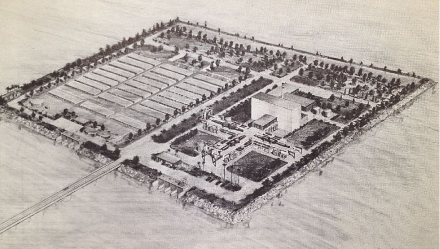
In a visionary speech, called “The Next Stage of Nuclear Energy,” Weinberg developed even more this idea of building “Food factories in the desert”:
“One can now visualize a new kind of desert agriculture, conducted in units so highly rationalized as to be designated « food factories » rather than farms. In these food factories, plants would be watered and fertilized at precisely the right time, and in precisely the right amounts. Fortunately fertile coastal deserts suitable for such food factories occur in many parts of the world.
The food factory would naturally be accompanied by other energy-intensive chemical processes, particularly those based on electrolytic hydrogen. I have already mentioned production of ammonia; one could imagine other processes such as reduction of iron ore by hydrogen, or electrolytic refining of bauxite to produce aluminium, or production of caustic and chlorine, and thence polyvinyl chloride (PVC) plastics.
Altogether what one contemplates is the nuclear powered agro-industrial complex already alluded to by AEC Chairman Seaborg in his opening remarks. This summer we conducted at the Oak Ridge National Laboratory a study under the guidance of Professor E.A. Mason of the Massachusetts Institute of Technology to examine in some detail just what such a nuclear powered agro-industrial complex might look like.
Even this near term complex, based on energy from light water reactors, seems surprisingly attractive. In this complex, a variety of crops would be grown on 140,000 acres of irrigated desert. Ammonia, phosphorus from phosphate rock, caustic, chlorine, and salt would be manufactured.
The total investment (including a 2000 Mwe reactor and a 500 million gallons a day desalting plant) comes to about $900 million. The annual value of products produced is $330 million, of which $100 million are agricultural products.
The profit on the venture is computed to be $136 million per year, or 15% of the capital investment. I believe that the nuclear powered agro-industrial complex may well become an impressively powerful instrument for development. But it is idle to speak of the agro-industrial complex unless the main ingredient — the cheap and reliable reactor — is available.” 8
On June 13, hardly days after the six day’s war, AEC chairman Seaborg wrote a letter to Johnson’s Secretary of State Dean Rusk:
“The recent developments in the Middle East prompt me to recall to your attention certain projects which have been under consideration for this region for some time in the past. I am referring to the two dual-purpose nuclear desalting projects, one proposed for installation in Israel and the other proposed for installation in the United Arab Republic (Egypt and Syria were one single state between 1958 and 1961), which were the subject of your memorandum to the President of May 21, 1966 … It occurs to us that the possible usefulness of these projects in the overall settlement of the Middle East dispute may be rather significant …
As you know, both Israel and the UAR have attached considerable importance to their respective projects. The proposed Israeli project, in particular, always had the advantage of providing Israel with a source of water not subject to interruption by neighboring states and not dependent on the allocation of the already inadequate water resources of the Jordan Valley.
Once again, it seems to me that the recent events may well intensify the problem of water allocation in the area rather than ease it. One or more desalting plants would both add significantly to the total volume of water available to the region …
It is interesting to note that at the recent Water for Peace Conference in Washington, UAR and Israeli representatives participated in a collateral meeting of nations interested in nuclear desalting and reaffirmed the strong interest of their governments in these projects.”
In the same letter, Seaborg underlined that US assistance for a nuclear desalination program,
“could possibly be used to secure Israeli agreement to place its entire nuclear program, including the Dimona project, under IAEA safeguards. It seems to me that the recent events probably increase rather than decrease the danger that one or more of the Middle Eastern countries will feel, however mistakenly, that its best interest in the future would be served by the acquisition of nuclear weapons.”
On June 23, 1967, Lewis Strauss, who was a founding member and, starting 1953, the head of the AEC till 1958, pressured his friend and protector Eisenhower to speak up for nuclear desalination for peace in the Middle East, by giving him the following memo called “A proposal for our Time”:
“Attention to the debates in the United Nations since the end of May must convince the observer that an end to the trouble in the Near East is not in sight. The introduction of a new and dramatic element will be required to establish a climate in which peace can begin to be negotiated. The resources of diplomacy appear exhausted, and the « lie direct » has been exchanged so often that men can hardly be expected to reach agreement by rational discussion in the atmosphere which has been created.
“The two fundamental problems in the Near East are (a) water, and (b) displaced populations. It is these issues which have exacerbated international relationships in that area over the years, and they are not to be resolved by political or military measures. By a simple, bold, and imaginative step, it is in our power to solve both problems … Two of the installations would be located at appropriate points on the Mediterranean coast of Israel and a smaller one at the northern end of the Gulf of Aqaba in either Jordan or Israel, as the most suitable terrain may dictate….
“Were the President of the United States to electrify the world by such a proposal, as President Eisenhower did in his Atoms-for-Peace speech to the United Nations in 1953, it would be hailed and welcomed by millions who now can see no way out of the morass in which the powers are presently floundering with its threat of triggering more widespread war. The proposal might well be the beginning of a new life in the lands of the oldest civilizations.
“The proposal, of course, does not settle the boundary disputes and other acute issues now confronting the belligerents, but their settlement would be immensely accelerated and facilitated by the pressure from all sides to get ahead with such a project where delay would be counted in human lives and misery. It could be announced that no affirmative steps would be taken until negotiations at least began. In the atmosphere that would immediately follow such a proposal, the leaders of the Near Eastern countries would be invited to come together on the basis of the proposals. They have a common forum in the International Atomic Energy Agency.”
“The introduction of fresh water from all three plants into the arid and semi-arid areas would have the effect of opening to settlement many hundred square miles which heretofore have never supported human life (other than on a nomadic basis), and the controversy over the division of the Jordan River would become de minimis.
“The work of building the great plants, laying the pipe lines, constructing reservoirs, power lines, irrigation ditches, etc., will absorb the unskilled labor of thousands of displaced persons. When the plants are in operation, the labor force could be settled in irrigated areas under conditions far superior to any life that they have ever experienced.
“Solely as a measure of magnitude, it might be noted that the completed project will represent substantially less than one year’s expenditure on the moon program. It will pay for itself and return income in perpetuity, retiring the borrowings incurred and rewarding the governments and individuals with vision enough to have subscribed to it initially.
“Cooperation of the Arab and Israeli governments will be necessary in order to agree upon a modus vivendi for allocating water and power, and it will be apparent that any government which simply declined to discuss or participate in such a cooperative arrangement would have to answer to its citizens sooner or later.” 9
Lewis Strauss

Lewis Strauss, started his career, not in nuclear science, but working as an investment banker at the Wall Street investment bank Kuhn, Loeb & Co. On March 5, 1923, he married Alice Hanauer, the daughter of Jerome J. Hanauer, who was one of the Kuhn Loeb partners.
But Strauss was also a philanthropist financing and leading several Jewish organizations. In 1933 he was a member of the executive committee of the American Jewish Committee. He was active in the Jewish Agricultural Society, for whom by 1941 he was honorary president. By 1938 he was also active in the Palestine Development Council, the Baron de Hirsch Fund, and the Union of American Hebrew Congregations.
However, he was not a Zionist and opposed the establishment of a Jewish state in Mandatory Palestine. He did not view Jews as belonging to a nation or a race; he considered himself an American of Jewish religion, and consequently he advocated for the rights of Jews to live as equal and integral citizens of the nations in which they resided.
Politically, Strauss got befriended and worked directly with President Herbert Hoover and felt irritated by FDR.
Edmond de Rothschild

One month after Strauss memo to Eisenhower, on July 18, US Ambassador Bruce reported the fact that French-Swiss banker Edmond Adolphe de Rothschild, in two letters to the London Times, had advocated for three nuclear desalting plants for Israel, Jordan, and the Gaza Strip to assist in the resettlement of more than 200,000 refugees.
This provoked comments and questions in the House of Commons, which generally approved the idea or at least further exploration of it.
British Prime Minister Wilson was convinced of the technical-economic feasibility of the plan, but the Foreign Office was concerned about the cost.
According to Embassy officials in London: “Apart from the obvious political difficulties, it was mainly a question of a very large amount of cheap money, which the UK did not have available.”
However, Edmond de Rothschild was apparently willing to put up 1 million pounds sterling of his own money. 10
Humanitarian and/or Business Plan?
Both Strauss and Rothschild shared the same idea, that of forming a corporation with a charter resembling that of COMSAT, a public, federally funded corporation created in 1962 intended to develop a commercial international satellite communication system. Although Comsat was government regulated, it was equally owned by some major communications corporations and independent investors.
The new corporation, wrote Strauss, should be created,
“with the Government subscribing to half of the stock, the balance to be offered for public subscription in the security markets of the world. The amount thus to be raised, say $200,000,000, would be used to begin construction of the first of three large nuclear plants for the dual purpose of producing kilowatts of electrical energy and desalting sea water, with emphasis on the latter purpose.”
“Private capital both in the United States and Great Britain would certainly respond to the challenge of such an enterprise on the initiative of the Government,” concluded Strauss.
Strauss and Eisenhower

Strauss was a staunch anti-communist and successfully lobbied Truman, who publicly announced the decision, as demanded by Strauss, to develop the hydrogen bomb on January 31, 1950. Less than three years later, the US detonated the world’s first H-bomb, only to have the Soviets follow suit 10 months later. Strauss’ determination to develop the hydrogen bomb was doggedly opposed by physicist J. Robert Oppenheimer, the chairman of the AEC’s general advisory committee who led the Manhattan Project in Los Alamos, New Mexico. Fearing the hydrogen bomb would only accelerate a dangerous Cold War arms race, Oppenheimer had argued for more openness about the size and capabilities of America’s nuclear arsenal, which Strauss thought would only benefit the Soviets.
After leaving the AEC in 1950, Strauss re-entered government when newly elected President Dwight D. Eisenhower appointed him as an atomic energy adviser in February 1953. Strauss, who had been a major donor to Eisenhower’s presidential campaign, wielded considerable power as all federal agencies were required to clear their atomic-related activities with him. Months later, Eisenhower asked Strauss to chair the AEC. Strauss agreed on one condition: that Oppenheimer no longer serve as a consultant to the commission…
Strauss’ plan for desalination became known as the “Strauss-Eisenhower plan” because Eisenhower, whose major speech Atoms for Peace at the UNGA in 1953 had been widely welcomed by the American public, published an article, largely inspired by the Strauss 1967 memo and edited by editor in chief of Reader’s Digest Ben Hibbs in that magazine’s June 1968 edition.
The full text of Eisenhower’s article was introduced as early on May 16 in the Congressional record (p. 13756), by Senator James G. Fulton.
Noteworthy, the fact that Robert F. Kennedy, who saved the world from nuclear extinction by using his back channels with Russian officials, was assassinated on June 8 of the same year.
In the overall inspiring article in his Reader’s Digest, former president Eisenhower, visibly convinced by Admiral Lewis Strauss and his banker’s friends such as Edmond de Rothschild who thought it was good business, wrote that:
“There is every reason to suppose that it could be a successful, self-sustaining business enterprise, whose revenues would derive from the sale of it products – water and electricity – to the users. Our government would make an initial investment in some of the corporation’s stock, and the rest would be sold to private investors in the security markets of the world. Additional money would be raised through the international marketing of convertible debentures. We are assured by international bankers that the financial world, under normal conditions, would welcome such an investment opportunity.”
However, Eisenhower made an extremely crucial point, that is very relevant for today:
”Most of the professional diplomats seem to think that we must have peace in the Middle East before the plan can be implemented. I contend that the reverse is true: the proposal itself is a way to peace.”
Unfortunately, in his Reader’s Digest article, the former president, or the editor, or by common decision of both, left out a key passage of Strauss earlier (June 1967) proposal, a passage implicitly proposing to make the Middle East desalting proposal the cornerstone for ending the Cold War!
Strauss, interestingly enough, had changed the axioms of his thinking, because the view he presented in 1967 (start some sort of peaceful cooperation with the USSR) was miles away from his views in 1950 (contain the Soviets at all cost). That said key passage reads as follows:
“Design and construction contracts would be let on bids in the several countries which have had experience in building large nuclear reactors, i.e., the United States, the United Kingdom, France, and the USSR.”
Those days Political parties
While today’s US party platforms are utter lunacy, in 1968, when Nixon was running against Humphrey and Wallace, voters could choose between two parties favoring nuclear desalination!
The Democratic party platform:
“To maintain our leadership in the application of energy, we will push forward with research and development to assure a balanced program for the supply of energy for electric power, both public and private. This effort should go hand in hand with development of « breeder » reactors and large-scale nuclear desalting plants that can provide pure water economically from the sea for domestic use and agricultural and industrial development in arid regions, and with broadened medical and biological applications of atomic energy. In addition to the physical sciences, the social sciences will be encouraged and assisted to identify and deal with the problem areas of society.
“… Lasting peace in the Middle East depends upon agreed and secured frontiers, respect for the territorial integrity of all states, the guaranteed right of innocent passage through all international waterways, a humane resettlement of the Arab refugees, and the establishment of a non-provocative military balance. To achieve these objectives, we support negotiations among the concerned parties. We strongly support efforts to achieve an agreement among states in the area and those states supplying arms to limit the flow of military equipment to the Middle East. We support efforts to raise the living standards throughout the area, including desalinization and regional irrigation projects which cut across state frontiers.” 11
The Republican Party platform:
“We support efforts to increase our total fresh water supply by further research in weather modification, and in better methods of desalination of salt and brackish waters.”
And on the Middle East, it said:
“To replace the ancient rivalries of this region with new hope and opportunity, we vigorously support a well conceived plan of regional development, including the bold nuclear desalination and irrigation proposal of former President Eisenhower.” 12(*10)
Conclusion
In one way or another, Middle East Peace, based on the sharing of water and energy obtained by the most advanced technologies (in terms of energy density), were on the agenda those days, and sometimes even conceptualized as the cornerstone of a potential new international architecture of security and mutual development ending the geopolitics of the Cold War.
Lyndon LaRouche’s proposals in 1975 and his Oasis plan currently proposed and promoted by the international Schiller Institute want to do exactly that. 13

LaRouche’s « Blue Peace » Oasis plan, to be put on the table of diplomatic negotiations as the « spine » of a durable peace agreement », includes:
- Israel’s relinquishment of exclusive control over water resources in favor of a fair resource-sharing agreement between all the countries in the region;
- The reconstruction and economic development of the Gaza Strip, including the Yasser Arafat International Airport (inaugurated in 1998 and bulldozered by Israeli in 2002), a major seaport backed up by a hinterland equipped with industrial and agricultural infrastructure.
- A floating, underwater or off-shore desalination plant will be stationed in front of Gaza.
- The construction of a fast rail network reconnecting Palestine (including Gaza) and Israel to its neighbors;
- The construction, for less than 20 billion US dollars of both the Red-Dead and the Med-Dead water conveyance system composed of tunnels, pipelines, water galeries, pumping stations, hydro-power units and nuclear powered desalination plants.
- Salted sea water, arriving at the Dead Sea, before desalination, will « fall » through a 400 meter deep shaft and generate hydro-electricity.
- Following desalination, the fresh water will go to Jordan, Palestine and Israel; the brine will refill and save the Dead Sea.
- The nuclear powered desalination plant will produce heat and electricity with « hybrid desalination » combining evaporation and Reverse Osmosis (RO) ;
- The industrial heat of the high temperature reactors (HTR) will also be tapped for industrial and agricultural purposes;
- The reservoirs of the water conveyance systems will also function as a Pumped Storage Power Plant (PSPP), essential for regulating the region’s power grids;
- Part of the seawater going through the Med-Dead Water conveyance system will be desalinated in Beersheba, the « capital of the Negev » whose population, with new fresh water supplies, can be doubled.
- New cities and « development corridors » will grow around the new water conveyance systems.
- Israel’s Dimona nuclear center and power plant (currently a military reactor and medical nuclear waste treatment center) can form the basis to create a civilian nuclear program and contribute to the construction of nuclear desalination plants. Jordan can contribute to the program with it vast reserves of thorium and uranium.
- US and Israeli plans to prepare the housing of 500,000/1 million people in the Negev exist but should be entirely reconfigured in terms of both scope and intent. They cannot be a mere extension of exclusively Jewish settlements, but should offer the opportunity to all Israeli citizens, in peaceful cooperation with the Bedouins who live there, the Palestinians and others, to roll back a common enemy: the desert.
- The policy of illegal settlements in the West Bank shall be halted. Settlers will be encouraged (through taxation, etc.) to relocate to the Negev, where they, in a shared effort with the Bedouins, Palestinians and others, can take up productive jobs and make the desert bloom (62% of Israeli territory).
PS: The Oasis Plan plan aims to bring peace to all through mutual development. It has nothing to do with Netanyahu’s Ben-Gurion canal project, a megalomaniac plan for a navigation canal connecting the Red Sea with the Mediterranean aimed to compete with the Suez Canal.
NOTES:
- The British Government was reported greatly concerned with the Russian arms offers; Prime Minister Eden regarded the offer to Egypt as the most “sinister” development in the East-West conflict since the Soviets took over Czechoslovakia. The British Government informed the United States in October 1955 it regarded a Russian undertaking to construct and finance the High Aswan Dam following the sale of Czech arms to Egypt would be a very serious blow to Western prestige and influence in the Middle East, providing the Russians with a means of exercising a dominating influence politically and economically in this area. ↩︎
- Myrl Kennedy Bailey, 1966 Thesis, « THE POLICIES OF- JOHN FOSTER DULLES RELATIVE TO THE SUEZ CRISIS OF 1956. »
↩︎ - Karel Vereycken, Israel-Palestine, Time to Make Water a Weapon for Peace, artkarel.com, March 2024. ↩︎
- Public Papers of the Presidents of the United States: Lyndon B. Johnson, 1967, Book I, pages 555-558. ↩︎
- Department of State, SCI Files: Lot 69 D 217, The Department during the Administration of Lyndon B. Johnson, November 1963-January 1969, Vol. XI, Science and Technology. The proceedings of the conference were published as the “International Conference on Water for Peace,” May 23-31, 1967. ↩︎
- Letter from Harrar to Weinberg. ↩︎
- Letter from Weinberg to Bell. ↩︎
- https://www.iaea.org/sites/default/files/publications/magazines/bulletin/bull9-6/09604701121.pdf ↩︎
- https://history.state.gov/historicaldocuments/frus1964-68v34/d166 ↩︎
- Airgram A-222 from London, July 18; National Archives and Records Administration, RG 59, Records of the Department of State, Central Files, 1967-69, E 11-3 NEAR EAST. ↩︎
- https://www.presidency.ucsb.edu/documents/1968-democratic-party-platform ↩︎
- https://www.presidency.ucsb.edu/documents/republican-party-platform-1968 ↩︎
- See note 1. ↩︎
Israël-Palestine: faisons de l’eau une arme pour la Paix !


« Si nous réglons tous les problèmes du Proche-Orient, mais pas celui du partage de l’eau, notre région explosera. La paix ne sera pas possible. » (Yitzhak Rabin, ancien Premier ministre israélien, 1992)
« On ne fait la paix qu’avec ses ennemis. » (Yitzhak Rabin)
Sommaire:
1. Géographie du Proche-Orient
2. Ressources
3. Hydrographie du bassin du Jourdain
A. Source
B. Affluents
C. Lac Tibériade, lac Kinneret, mer de Galilée
D. Yarmouk
4. Sources d’eau pour Israël-Palestine
A. Eaux de surface
B. Eaux souterraines
C. Dessalement
D. Eaux usées
5. Projets d’aménagement
A. Aqueduc national
B. Plan Johnston
C. Canal d’irrigation de Ghor
D. Aqueduc mer Morte – Méditerranée
E. Aqueduc mer Morte – mer Rouge
F. Les projets turcs
G. Vices cachés et non-application des accords d’Oslo
H. Canal de navigation Ben Gourion
I. Plan Oasis
6. Alvin Weinberg, Yitzhak Rabin et Lyndon LaRouche
Cet article offre aux lecteurs des clés. Pour comprendre l’histoire des guerres de l’eau qui continuent à ravager le Proche-Orient, il est essentiel d’en comprendre les enjeux géologiques, hydrographiques, géographiques et politiques. Dans la deuxième partie, nous examinerons les différentes options d’aménagement des ressources en eau en vue d’une stratégie de sortie de crise. Nous aborderons l’enjeu gazier, autre sujet de conflit ou de coopération potentielle, dans un prochain article.
1. Géographie
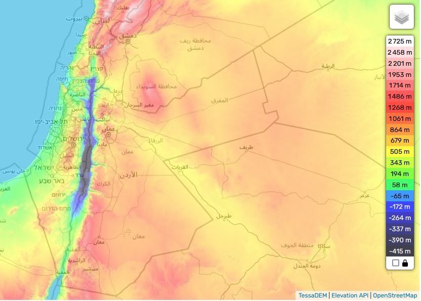
Quatre pays se partagent le bassin du Jourdain, le Liban, la Syrie, la Jordanie et Israël, auxquels il faut ajouter les territoires palestiniens de Cisjordanie et de Gaza.
Logée dans le creux d’une dépression tectonique se situant sur la grande faille qui court depuis Aqaba jusqu’à la Turquie, la vallée du Jourdain est l’un des bassins de vie les plus bas au monde, puisqu’il se jette dans la mer Morte, à 421 mètres sous le niveau des océans.
Voir carte topographique interactive
De plus, il s’agit d’un bassin endoréique, c’est-à-dire d’un cours d’eau n’aboutissant ni à la mer ni à l’océan. Comme pour le bassin de la mer d’Aral en Asie centrale, ceci implique que toute eau puisée ou détournée en amont réduit le niveau de son réceptacle ultime, la mer Morte (voir plus bas) et pourrait même, éventuellement, la faire disparaître.

Tout en restant une artère fondamentale pour toute la région, le Jourdain est un fleuve présentant plusieurs inconvénients : son cours n’est pas navigable, son débit reste peu élevé et ses eaux, fortement salées, sont polluées.
Comme un des facteurs clés de l’équation (le nexus) « eau, énergie, nourriture », trois facteurs dont l’interdépendance est telle qu’on ne peut les traiter isolément, l’aménagement de la ressource en eau reste un enjeu capital et occupe une place primordiale pour tout avenir partagé entre Israël et ses voisins arabes.
2. Pluviométrie et ressources hydriques
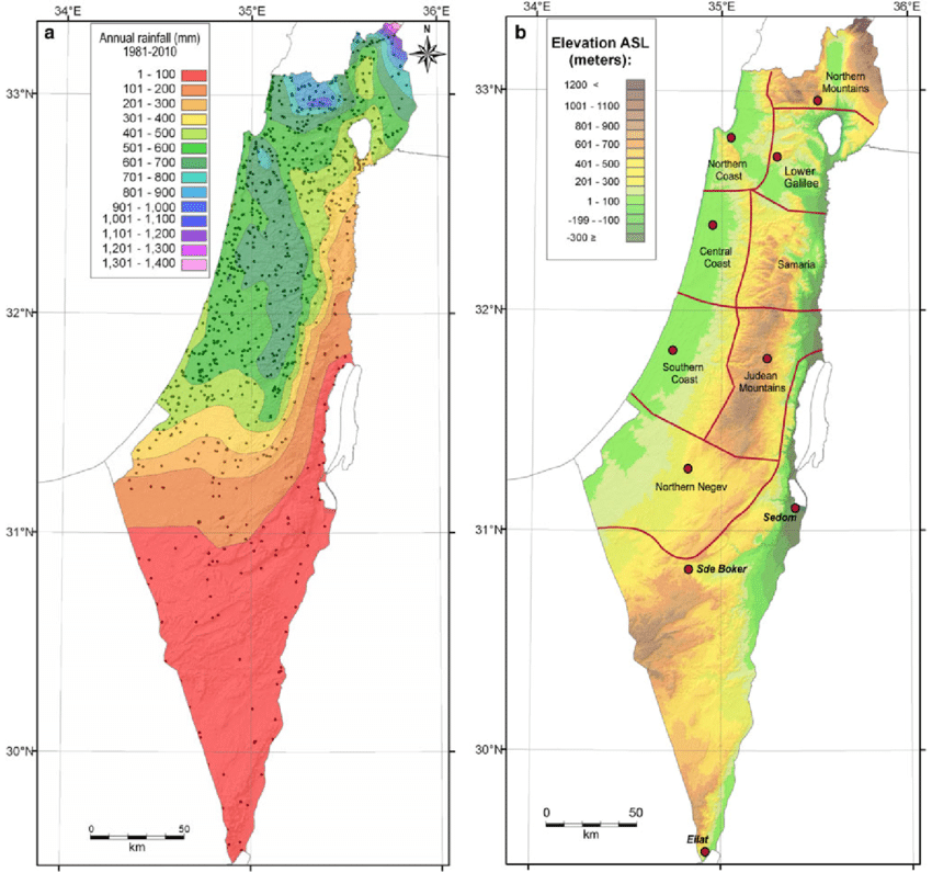
Le Moyen-Orient forme une longue bande aride qui n’est interrompue qu’accidentellement par des zones où les précipitations sont abondantes (autour de 500-700 mm/an), par exemple les montagnes du Liban, de la Palestine, du Yémen.
Géographiquement, une bonne partie du Moyen-Orient est située au Sud de l’isohyète (ligne imaginaire reliant des points d’égales précipitations) indiquant les 300 mm/an. Cependant, les précipitations n’ont qu’un effet limité du fait de leur saisonnalité (octobre-février).
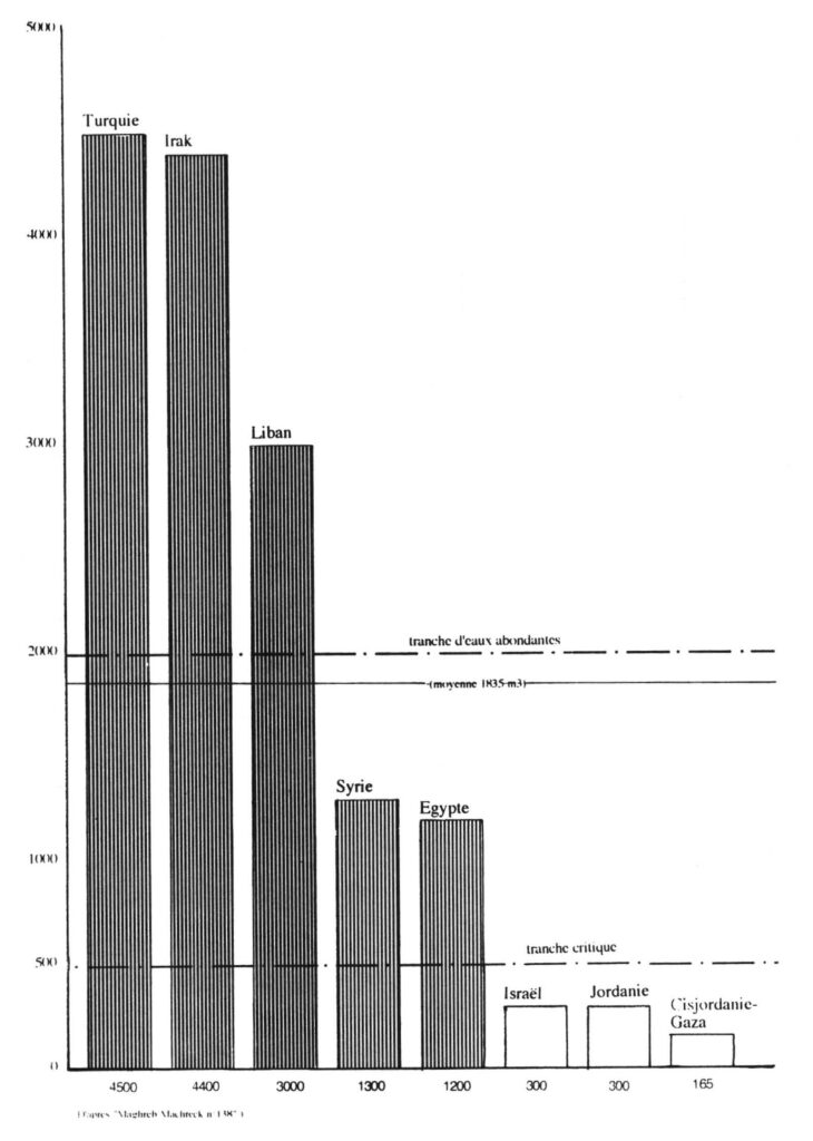
Par conséquent, le débit et les crues des cours d’eaux sont irréguliers au fil de l’année, en plus d’être irréguliers entre les années. Idem pour l’alimentation des nappes phréatiques.
Maintenant, en termes de ressources totales en eau par personne et par Etat, elles sont très inégalement réparties.
État par État, les ressources totales en eau sont très inégalement réparties dans la région :
–La Turquie et l’Irak disposent de plus de 4 000 mètres cubes par personne et par an, et le Liban d’environ 3 000 m³/personne/an, ce qui est supérieur à la moyenne régionale (1 800 m³/personne/an).
–La Syrie et l’Égypte ont environ 1 200 m³/personne/an, soit un tiers de moins.
D’autre part, certains pays se situent en dessous de la fourchette critique de 500 m³/an/habitant :
–Israël et la Jordanie disposent de 300 m³/an/habitant, et les Territoires palestiniens (Cisjordanie-Gaza) de moins de 200 m³/an/habitant. Ils se trouvent dans ce que l’Organisation mondiale de la santé (OMS) appelle une situation de « stress hydrique ».
Le Moyen-Orient jouit d’une abondance d’eau à l’échelle régionale, mais compte de nombreuses zones en pénurie chronique, à l’échelle locale.
3. Hydrographie du bassin du Jourdain
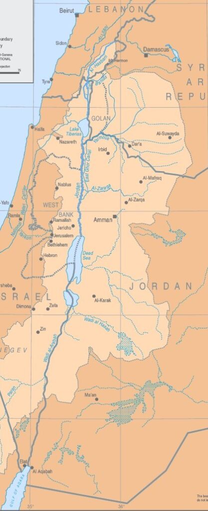
A. Source
Long de 360 km de long, le fleuve Jourdain naît de l’eau qui descend des pentes du Jabal el-Cheikh (mont Hermon) au sud du Liban, sur la frontière avec la Syrie.
B. Affluents
Une fois passée la frontière israélienne, trois affluents rejoignent le Jourdain à environ 6 km en amont de l’ancien lac Houleh (aujourd’hui assaini) :
1. Le Hasbani, avec un débit de 140 millions de mètres cubes par an, prend sa source au Liban, qu’il parcourt sur 21 km. Son cours supérieur varie fortement en fonction des saisons, alors que son cours inférieur est plus régulier.
2. Long de 30 km, le Banias, actuellement placé sous le contrôle d’Israël, a un débit annuel proche de celui de l’Hasbani (140 MMC/an). Il prend sa source en Syrie sur les hauteurs du Golan, et s’étire en Israël sur environ 12 km avant de se jeter dans le Haut Jourdain.
3. Le Nahr Leddan (ou le Dan) se forme en Israël lorsque se rejoignent les eaux provenant en majorité des hauteurs du Golan. Bien que restreint, son cours reste stable et son débit annuel est supérieur à ceux des deux autres affluents du haut Jourdain, puisqu’il dépasse les 250 MMC/an.
C. Lac de Tibériade (Mer de Galilée, lac de Kinneret)
Le Jourdain parcourt ensuite 17 km de gorges étroites pour arriver au lac de Tibériade, où la salinité est forte, d’autant plus qu’on a détourné des cours d’eau douce qui s’y jetaient. Le lac de Tibériade reçoit cependant les eaux des multiples petits cours d’eau traversant les hauteurs du Golan.
D. La rivière Yarmouk
Le Jourdain rencontre alors la rivière Yarmouk (arrivant de Syrie), puis décrit des méandres sur 320 km (109 km à vol d’oiseau) avant d’atteindre la mer Morte. Ces 320 km sont occupés par une plaine humide (le zor humide), à la végétation subtropicale, dominée des deux côtés (cisjordanien et jordanien) par des terrasses sèches et ravinées.
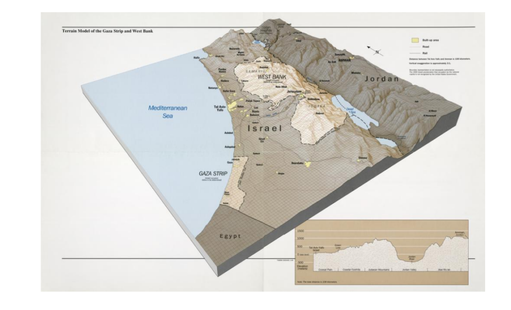
4. Sources d’eau pour Israël
L’État hébreu dispose de quatre principales sources d’approvisionnement en eau.
A. Eaux de surface
Israël bénéficie des réserves en eau douce du lac de Tibériade en Galilée, au nord du pays. Traversée par le Jourdain, cette petite mer intérieure représente 25 % des besoins en eau d’Israël. Cette source d’eau a été sanctuarisée par son annexion dans les hauteurs du Golan et son occupation au Sud Liban.
B. Eaux souterraines
En plus des eaux de surface (rivières), le pays peut compter sur ses aquifères côtiers, de Haïfa à Ashkelon. Située entre Israël et la Cisjordanie occupée, la principale nappe phréatique, l’aquifère de montagne Yarkon-Taninim, a une capacité de 350 MMC/an. Dans le nord-est et l’est de la Cisjordanie se trouvent deux autres nappes, d’une capacité respective de 140 et 120 MMC/an.
C. Dessalement de l’eau de mer


Cinq usines de dessalement construites le long du littoral israélien – à Soreq, Hadera, Ashkelon, Ashdod et Palmachim – fonctionnent actuellement et deux autres sont en cours de construction. Ensemble, ces usines devraient représenter 85 à 90 % de la consommation annuelle d’eau d’Israël, ce qui constitue un changement de cap remarquable.
L’usine de dessalement de Sorek, située à environ 15 km au sud de Tel Aviv, est devenue opérationnelle en octobre 2013 avec une capacité de traitement de l’eau de mer de 624 000 m³/jour, ce qui en fait la plus grande usine de dessalement d’eau de mer au monde. L’installation de dessalement utilise le processus d’osmose inverse de l’eau de mer (SWRO) pour fournir de l’eau au système national de transport d’eau d’Israël (NWC, voir ci-dessous). La construction d’une douzaine d’autres unités de ce type est envisagée.
Israël, qui est confronté à de graves sécheresses depuis 2013, a même commencé à pomper de l’eau de mer dessalée de la Méditerranée dans le lac de Tibériade, une performance unique au monde. Alors qu’Israël était confronté à une pénurie d’eau il y a deux décennies, il exporte désormais de l’eau vers ses voisins (mais pas trop vers la Palestine). Israël fournit actuellement 100 millions de m3 à la Jordanie et répond à 20 % de ses besoins en eau.
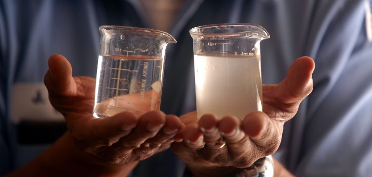
A partir de 100 litres d’eau de mer, on peut obtenir 52 litres d’eau potable et 48 litres d’eau saumâtre. Bien que très performant et très utile, ce type de technologie reste à perfectionner car pour l’instant, il rejette en mer des saumures qui perturbent l’écosystème marin. Pour réduire cette pollution et la transformer en déchets solides, il faut multiplier l’opération de nombreuses fois et donc la consommation énergétique.
D. Recyclage des eaux usées
Le pays se vante de recycler entre 80 % et 90 % de ses eaux usées pour alimenter les cultures agricoles. Ces eaux traitées, utilisées pour l’irrigation, sont appelées effluents. Leur taux d’utilisation en Israël est l’un des plus élevés au monde.
Le traitement est effectué par 87 grandes stations d’épuration des eaux usées qui fournissent plus de 660 millions de m3 par an. Cela représente environ 50 % de la demande totale en eau pour l’agriculture et environ 25 % de la demande totale en eau du pays. Israël a pour objectif de doubler la production d’effluents pour le secteur agricole d’ici 2050.
5. Projets d’aménagement

Pour Israël, se doter de ressources en eau dans une région désertique, par la technique, la force militaire et/ou la diplomatie, a été dès le début un impératif régalien pour répondre aux besoins d’une population en forte croissance et, aux yeux du reste du monde, une démonstration de sa supériorité.
Cette symbolique se manifeste notamment à travers la figure du père de l’État hébreu, David Ben Gourion (1886-1973), qui avait pour objectif de faire « fleurir » le désert du Néguev, au sud du pays.
Dans son ouvrage Southwards (1956), Ben Gourion décrit ainsi son ambition :
« C’est absolument vital pour l’État d’Israël, à la fois pour des raisons économiques et sécuritaires, d’aller vers le sud : nous devons diriger l’eau et la pluie vers là-bas, y envoyer les jeunes pionniers […] ainsi que l’essentiel des ressources de notre budget au développement. »
A. Aqueduc national
De 1959 à 1964, les Israéliens ont construit le National Water Carrier of Israël (NWC ou aqueduc national), à ce jour le plus grand projet hydraulique du pays.
Les premières idées sont apparues dans le livre Altneuland (1902) de Theodor Herzl, dans lequel il parle d’utiliser les sources du Jourdain à des fins d’irrigation et de canaliser l’eau de mer pour produire de l’électricité depuis la Méditerranée, près de Haïfa, jusqu’à un canal parallèle au Jourdain et à la mer Morte, en passant par les vallées de Beit She’an et du Jourdain.
« Tout l’avenir économique de la Palestine dépend de son approvisionnement en eau », déclarait en 1919 Chaïm Waizmann, le dirigeant de l’Organisation sioniste mondiale. Seulement, il préconisait d’intégrer la vallée du Litani (sud du Liban actuel) à l’Etat palestinien.
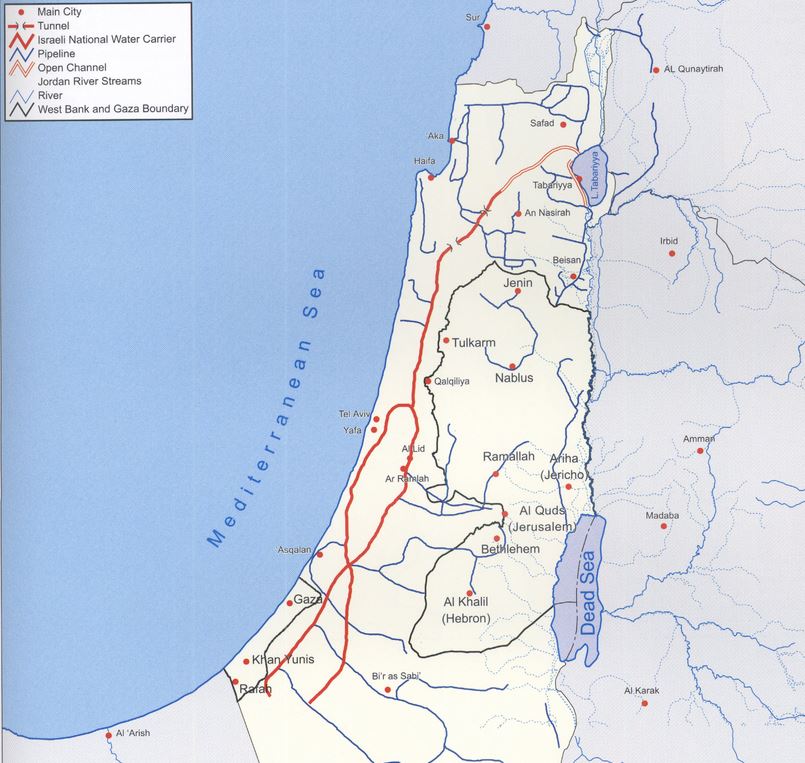
Avec le NWC, l’écoulement naturel du Jourdain est empêché par la construction d’un barrage, construit au sud du lac de Tibériade. A partir de là, l’eau est déviée vers l’aqueduc national, un système long de 130 km combinant tuyaux géants, canaux ouverts, tunnels, réservoirs et stations de pompage à grande échelle. L’objectif est de transférer l’eau du lac de Tibériade vers le centre très peuplé et le sud aride, y compris le désert du Néguev.
Lors de son inauguration en 1964, 80 % de son eau était allouée à l’agriculture et 20 % à l’eau potable. En 1990, l’aqueduc national fournissait la moitié de l’eau potable en Israël. En y intégrant l’eau provenant des usines de dessalement d’eau de mer, il approvisionne aujourd’hui Tel Aviv, une ville de 3,5 millions d’habitants, Jérusalem (1 million d’habitants) et (hors période de guerre) Gaza et les territoires occupés de Cisjordanie. Depuis 1948, la superficie des terres agricoles irriguées est passée de 30 000 à 186 000 hectares. Grâce à la micro-irrigation (goutte à goutte, y compris sous la surface), la production agricole israélienne a augmenté de 26 % entre 1999 et 2009, bien que le nombre d’agriculteurs ait chuté de 23 500 à 17 000.
Cependant, depuis sa construction, le projet de détournement de l’eau du Jourdain a été une source de tension, en particulier avec la Jordanie et la Syrie, sans parler des Palestiniens, largement exclus des bénéfices économiques du projet.
La guerre de l’eau
En lançant son aqueduc national, Israël a fait cavalier seul, alors que pour le reste du monde, il était clair que ce détournement des eaux du Jourdain allait susciter de vives tensions avec ses voisins.
Dès 1953, Israël, pour préparer le travail, procède sans consulter quiconque à l’assèchement du lac Houleh, au nord du lac Tibériade, entraînant des escarmouches avec la Syrie.
En 1959, démarre le chantier de l’aqueduc national, interrompu dans un premier temps par l’arrêt des financements par les Etats-Unis, qui ne veulent pas voir monter la violence dans le contexte de la Guerre froide.
Rappelons que, suite à la crise de Suez de 1956, l’Union soviétique s’installe durablement en Syrie comme puissance protectrice des pays arabes contre la « menace israélienne ». Elle obtient, dans le cadre du déploiement de sa présence navale en Méditerranée, des facilités pour sa flotte à Lattaquié en Syrie et un traité d’assistance militaire mutuel est signé.
Cependant, Israël parvient à reprendre le chantier qu’elle poursuit discrètement. La prise d’eau dans le lac de Tibériade commence en juin 1964 dans le plus grand secret. Lorsque les pays arabes l’apprennent, la colère est grande. En novembre 1964, l’armée syrienne tire sur des patrouilles israéliennes autour de l’usine de traitement de l’aqueduc national, provoquant des contre-attaques israéliennes. En janvier 1965, l’aqueduc est la cible du premier attentat du Fatah (organisation luttant pour la libération de la Palestine) dirigé par Yasser Arafat.
Les États arabes finissent par se rendre à l’évidence qu’ils ne pourront jamais arrêter le projet par une action militaire directe. Ils changent de tactique et adoptent le Plan de diversion des sources du Jourdain, immédiatement mis en œuvre en 1965, visant à détourner les eaux en amont du Jourdain vers le fleuve Yarmouk (en Syrie). Le projet était techniquement difficile et coûteux, mais s’il avait réussi, il aurait détourné 35 % de l’eau qu’Israël comptait retirer du cours supérieur du Jourdain.
Israël considère ce détournement comme une atteinte à ses droits souverains. Les relations dégénèrent et des affrontements frontaliers s’ensuivent, les forces syriennes tirant sur les agriculteurs et les patrouilles de l’armée israélienne, et les chars et l’artillerie israéliens détruisant les chars syriens ainsi que le matériel de terrassement utilisé pour le chantier de détournement.
En juillet 1966, l’armée de l’air israélienne bombarde un parc de matériel de terrassement et abat un MiG-21 syrien. Les États arabes abandonnent leur effort de détournement, mais le conflit se poursuit à la frontière israélo-syrienne, avec notamment une attaque aérienne israélienne sur le territoire syrien en avril 1967.
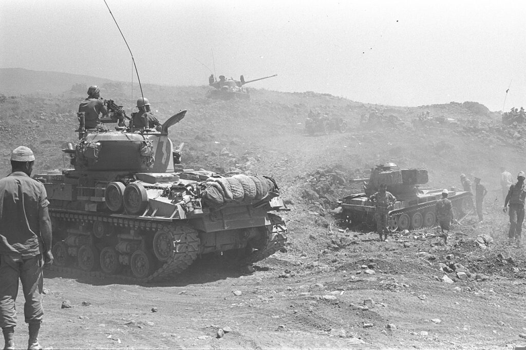
Pour bien des analystes, il s’agissait là d’un prélude à la guerre des Six-Jours, en 1967, amenant Israël à occuper le plateau du Golan pour protéger son eau. La guerre des Six jours modifie profondément la donne géopolitique du bassin, puisque Israël occupe à présent, en plus de la Bande de Gaza et du Sinaï, la Cisjordanie et le Golan.
Comme le précise Hervé Amiot dans « Eau et conflits dans le bassin du Jourdain« :
« De pays en aval, Israël passe à la position de pays en amont, lui permettant d’acquérir le contrôle de vastes ressources. Israël contrôle désormais 20 % de la rive nord du Yarmouk et occupe les hauteurs du Golan, contrôlant ainsi tous les petits cours d’eau se jetant dans le lac de Tibériade. De plus, l’occupation totale de la Cisjordanie permet de contrôler les importantes nappes phréatiques. »
En réalité, dès 1955, entre un quart et un tiers de l’eau provenait de la nappe du sud-ouest de la Cisjordanie. Aujourd’hui, les nappes de Cisjordanie fournissent 475 millions de m³ d’eau à Israël, soit 25 à 30 % de l’eau consommée dans le pays (et 50 % de son eau potable).
Deux mois après la prise des territoires occupés, Israël publie le décret militaire 92, transférant à l’armée israélienne l’autorité sur toutes les ressources en eau des territoires occupés et conférant « le pouvoir absolu de contrôler toutes les questions liées à l’eau au responsable des ressources en eau, nommé par les tribunaux israéliens ». Ce décret révoque toutes les licences de forage délivrées par le gouvernement jordanien et désigne la région du Jourdain comme zone militaire, privant ainsi les Palestiniens de tout accès à l’eau, tout en accordant à Israël un contrôle total sur les ressources en eau, utilisées pour soutenir ses projets de colonisation.
Rendre le Golan à la Syrie et reconnaître la souveraineté de l’Autorité palestinienne sur la Cisjordanie semble impossible pour Israël, au vu de la dépendance accrue de l’Etat hébreu envers les ressources hydriques de ces territoires occupés. L’exploitation de ces ressources continuera donc, malgré l’article 55 du règlement de la IVe Convention de la Haye, stipulant qu’une puissance occupante ne devient pas propriétaire des ressources en eau et ne peut les exploiter pour le besoin de ses civils.
B. Le plan Johnston
OBJECTIF : Dans le contexte de la guerre froide, contrer l’influence croissante de Nasser dans la région. Offrir une stabilité régionale en construisant barrages et canaux permettant un partage équitable des ressources en eau et fournissant de l’eau et de l’énergie à la fois à Israël et aux États arabes qui accueillent les « malheureux » réfugiés palestiniens.
En juillet 1952, un groupe d’officiers libres, dont Nasser, renversent la monarchie et créent la République Égyptienne. Une grande partie du monde arabe applaudit alors l’Egypte et sa volonté de mettre fin au colonialisme. En octobre de la même année, Eisenhower est élu président des Etats-Unis. Pour éviter que tout le monde arabe se rallie derrière Nasser et se coalise contre les Etats occidentaux, les Etats-Unis, tout en planifiant en secret l’élimination de Nasser, proposeront alors des politiques de développement séduisantes en échange d’une acceptation de leur domination. L’agitation nationaliste israélienne apparaît alors souvent pour Washington comme une menace. Si l’intérêt légitime d’Israël pour sécuriser son accès à l’eau, clé absolue de sa survie et de son développement, est pris en compte, Washington exige qu’on partage de façon équitable l’eau et qu’offre aux pays voisins des ressources suffisantes leur permettant d’accueillir les millions de Palestiniens exilés chez eux suite à la Nakba.
Face au risque de conflits, le gouvernement américain propose, dès 1953, donc des années avant qu’Israël lance son plan, une médiation pour résoudre les contentieux sur le bassin du Jourdain. Cela aboutit au « Plan unifié pour la vallée du Jourdain », dit « plan Johnston », du nom d’Eric Allen Johnston, l’envoyé pour l’eau du président américain Dwight Eisenhower.
Le 13 octobre 1953, le secrétaire d’État d’Eisenhower, John Foster Dulles, dans une lettre classée secrète, a expliqué à Johnston en quoi consistait sa mission et le 16 octobre, dans une déclaration publique, Eisenhower a expliqué :
« L’une des principales causes d’inquiétude au Proche-Orient est le fait que des centaines de milliers de réfugiés arabes vivent sans moyens de subsistance adéquats dans les États arabes. Les besoins matériels de ces personnes ont été pris en charge par l’Office de secours et de travaux des Nations unies (UNRWA)… Il est cependant évident depuis le début que tous les efforts doivent être faits par les pays concernés, avec l’aide de la communauté internationale, pour trouver un moyen de donner à ces malheureux l’occasion de retrouver leur autonomie personnelle.
L’un des principaux objectifs de la mission de M. Johnston sera d’entreprendre des discussions avec certains Etats arabes et Israël, en vue d’un développement mutuel des ressources en eau de la vallée du Jourdain sur une base régionale, dans l’intérêt de tous les habitants de la région.
(…) Une telle approche régionale promet une amélioration économique considérable dans les pays concernés grâce au développement de l’irrigation et de l’énergie hydroélectrique qui font cruellement défaut et grâce à la création d’une base économique sur la terre pour une proportion substantielle des réfugiés arabes. Je suis convaincu que l’acceptation d’un plan global de développement de la vallée du Jourdain contribuerait grandement à la stabilité du Proche-Orient et au progrès économique général de la région ».
Ce plan établit le caractère transfrontalier du bassin et propose un partage équitable de la ressource en accordant 52 % de l’eau à la Jordanie, 31 % à Israël, 10 % à la Syrie et 3 % au Liban.
Le plan Johnston, tout comme la Tennessee Valley Authority pendant le New Deal de FDR, était essentiellement basé sur la construction de barrages pour l’irrigation et l’hydroélectricité. L’eau était présente et correctement gérée, suffisante pour les besoins de la population de l’époque. Ses principales caractéristiques du plan étaient les suivantes:
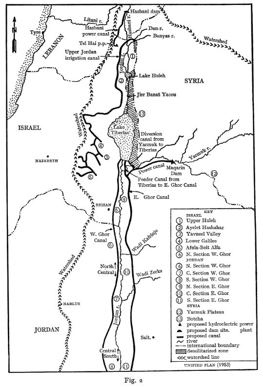
- un barrage sur la rivière Hasbani pour fournir de l’énergie et irriguer la région de Galilée ;
- des barrages sur les rivières Dan et Banias pour irriguer la Galilée ;
- le drainage des marais de Huleh ;
- un barrage à Maqarin sur la rivière Yarmouk pour le stockage de l’eau (capacité de 175 mmc) et la production d’électricité ;
- un petit barrage à Addassiyah sur le Yarmouk pour détourner ses eaux vers le lac de Tibériade et vers le sud le long du Ghor oriental ;
- un petit barrage à la sortie du lac de Tibériade pour augmenter sa capacité de stockage ;
- des canaux à écoulement par gravité le long des côtés est et ouest de la vallée du Jourdain pour irriguer la zone située entre le confluent du Yarmouk avec le Jourdain et la mer Morte ;
- des ouvrages de contrôle et des canaux pour utiliser les débits pérennes des oueds que les canaux traversent.
Voir les détails du plan Johnston dans cet article très complet :
Validé par les comités techniques d’Israël et de la Ligue arabe, ce projet n’exige pas qu’Israël renonce à son ambition de verdir le désert du Néguev. Pourtant, sa présentation à la Knesset, en juillet 1955, n’aboutit malheureusement pas à un vote. Le comité arabe approuve le plan en septembre 1955 et le transmet au conseil de la Ligue arabe pour approbation finale. Tragiquement, cette institution refuse, elle aussi, de le ratifier le 11 octobre, à cause de son opposition à un acte impliquant une sorte de reconnaissance d’Israël… L’erreur ici fut d’isoler la question de l’eau d’un accord plus général de paix et de justice résultant d’un développement mutuel.
Après la crise du canal de Suez en 1956, les pays arabes, à l’exception de la Jordanie, durcissent considérablement leur position à l’égard d’Israël et s’opposent désormais frontalement au plan Johnston, alléguant qu’il accroît la menace représentée par ce pays en lui permettant de renforcer son économie. Ils assurent aussi que l’accroissement de ses ressources hydriques ne peut qu’augmenter le mouvement de migration des Juifs vers l’État hébreu, réduisant ainsi les possibilités de retour des réfugiés palestiniens de la guerre de 1948…
On ne refait pas l’histoire, mais on peut penser que l’adoption du plan Johnston aurait pu éviter des conflits, notamment celui de 1967 qui coûta la vie à 15 000 Égyptiens, 6000 Jordaniens, 2500 Syriens et un bon millier d’Israéliens.
C. La réponse jordanienne: le canal du Ghor
OBJECTIF : construire la section jordanienne (le canal du Ghor oriental) du plan Johnston afin de disposer d’eau pour l’irrigation et la capitale de la Jordanie.

Presque au même moment où Israël achève son aqueduc national, entre 1955 et 1964, la Jordanie creuse de son côté le canal du Ghor oriental, qui débute à la confluence entre le Yarmouk et le Jourdain, dont il suit un cours parallèle jusqu’à la mer Morte, en territoire jordanien.
A l’origine, il s’agissait d’un projet plus vaste, le « Grand Yarmouk », qui prévoyait deux barrages de stockage sur cette rivière et un canal du Ghor occidental sur la rive occidentale du Jourdain. Cet autre canal ne fut jamais construit, Israël ayant pris entre-temps la Cisjordanie à la Jordanie, lors de la guerre des Six-Jours de 1967.
En fait, en déviant les eaux du Yarmouk pour alimenter son propre canal, la Jordanie se procure de l’eau pour sa capitale Amman et son agriculture, tout en asséchant, elle aussi, le fleuve Jourdain.
La région du bassin versant du Jourdain, en Jordanie, est une région d’une importance primordiale pour le pays. En effet, elle accueille 83 % de la population, les principales industries, ainsi que 80 % de l’agriculture irriguée. On y trouve également 80 % de la ressource hydrique du pays.
Or, le royaume hachémite, dont 92 % du territoire est désertique, se place parmi les pays les plus pauvres en eau. Alors qu’Israël dispose de 276 m³ d’eau douce naturelle disponible par an et par habitant, la Jordanie n’en compte que 179 m³, dont plus de la moitié provient des nappes phréatiques.
L’ONU considère d’ailleurs qu’un pays doté de moins de 500 m³ d’eau douce par an et par habitant souffre de « stress hydrique absolu ». Sans compter que depuis le début de la guerre civile syrienne, la Jordanie a accueilli près de 1,4 million de réfugiés sur son sol, en plus de ses 10 millions d’habitants.
Conçu en 1957, le canal du Ghor oriental fut réalisé entre 1959 et 1961. En 1966, la partie en amont jusqu’à Wadi Zarqa était achevée. Le canal, qui faisait alors 70 km de long, fut prolongé à trois reprises entre 1969 et 1987.
Les États-Unis, par l’intermédiaire de l’Agence américaine pour le développement international (USAID), ont financé la phase initiale du projet, après avoir obtenu du gouvernement jordanien l’assurance explicite que la Jordanie ne prélèverait pas plus d’eau du Yarmouk que ce qui lui avait été alloué dans le cadre du plan Johnston. Ils ont également participé aux phases ultérieures.
Les ouvrages hydrauliques de la région ont souvent pour éponymes de grandes figures politiques. C’est ainsi que le canal du Ghor oriental fut baptisé « King Abdallah Canal (KAC) » par Abdallah II, en l’honneur de son arrière-grand-père, le fondateur de la Jordanie. À l’occasion du traité de paix avec Israël en 1994, les deux pays se répartissent le débit du Jourdain et son voisin accepte de lui vendre de l’eau du lac de Tibériade.
D. Canal mer Morte – Méditerranée
OBJECTIF : produire de l’hydro-électricité et rendre Israël indépendant des approvisionnements en pétrole arabe.
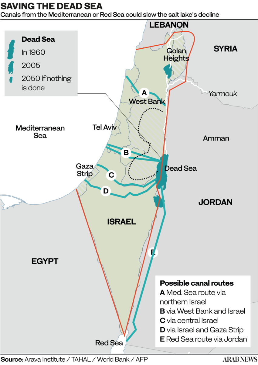
A : Traversée du seul territoire israélien ;
B et C : traversant Israël et la Cisjordanie (le plus court, 70 km) ;
D. Traversée de Gaza et Israël ;
E. Traversée de la Jordanie uniquement (la plus longue, 200 km).
L’idée d’un canal mer Morte-Méditerranée fut initialement proposée par William Allen en 1855, dans un ouvrage appelé The Dead Sea – A new route to India (La mer Morte, une nouvelle route vers l’Inde). À l’époque, on ignorait que le niveau de la mer Morte était très en dessous de celui de la Méditerranée et Allen a proposé ce canal comme alternative au canal de Suez.
Plus tard, plusieurs ingénieurs et hommes politiques ont repris l’idée, dont Theodor Herzl dans sa nouvelle de 1902, Altneuland. Si la plupart des premiers projets partent de la rive gauche du Jourdain (Jordanie), une version prévoit également un tracé sur la rive droite (Cisjordanie), scénario abandonné après 1967 lorsque la Cisjordanie tombe aux mains d’Israël.
Après des recherches approfondies, les ingénieurs allemands Herbert Wendt et Wieland Kelm ont proposé non pas un canal navigable, mais un aqueduc composé d’une galerie en charge orientée ouest-est, reliant la Méditerranée à la mer Morte.
Tirant profit de la différence de niveau entre la mer Méditerranée et la mer Morte le système vise essentiellement à alimenter la mer Morte en eau de mer tout en produisant de l’énergie hydro-électrique. Trois tracés sont envisagés, le plus court étant celui reliant la Méditerranée à la Mer Morte (70 km) en partant d’Ashdod en Israël et traversant la Cisjordanie.
En 1975, une étude détaillée de leur projet a fait l’objet d’une première publication dans la revue spécialisée allemande Wasserwirtschaft.

Le schéma s’explique comme ceci:
- La prise d’eau de mer se situe à Ashdod.
- Un canal ouvert fait écouler l’eau par gravité sur 7 km.
- De là, l’eau sous pression part dans un une galerie hydraulique en charge long de 65 km;
- L’eau arrive dans un lac de retenue de 3 km de long créé grâce un barrage situé au bord de la descente abrupte vers la mer Morte. A cet endroit, l’eau peut éventuellement servir au refroidissement d’une centrale thermique ou nucléaire dont la chaleur peut rendre des services dans le domaine industriel ou agricole.
- Par un puits qui part du fond du réservoir, l’eau descend abruptement de 400 mètres.
- Là, il actionne trois turbines d’une puissance de 100 MWe chacune.
- Enfin, par une galerie d’évacuation, l’eau de mer rejoint la mer Morte.
L’ONU votre contre !
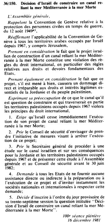
Cependant, comme le projet est élaboré exclusivement par Israël et sans aucune consultation avec ses voisins jordaniens, palestiniens et égyptiens, il se fracasse sur un mur d’opposition politique.
Bien entendu, comme pour tout projet d’infrastructure à grande échelle, de nombreux éléments doivent être adaptés, notamment les équipements touristiques, les routes, les hôtels, l’exploitation de la potasse jordanienne, les terres agricoles palestiniennes, etc.
On s’interroge également sur les tremblements de terre potentiels (très peu fréquents) et la différence de salinité de l’eau de la Méditerranée et de la mer Morte.
Le 16 décembre 1981, l’Assemblée générale des Nations unies, estimant que le projet de canal « violera le principe du droit international », adopte la résolution 36-150.
Cette résolution « prie le Conseil de sécurité d’envisager de prendre l’initiative de mesures visant à arrêter l’exécution de ce projet », et « demande à tous les Etats de ne fournir aucune assistance directe ou indirecte à la préparation ou à l’exécution de ce projet ».
E. Aqueduc mer Morte – mer Rouge
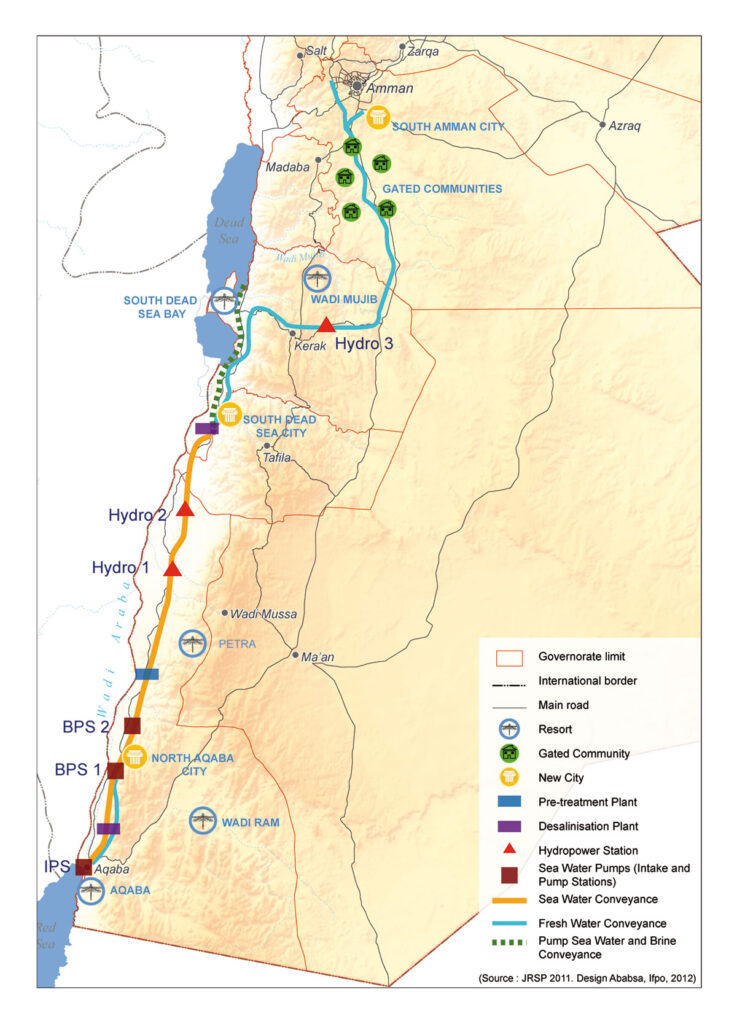
OBJECTIFS : Construire une usine de dessalement près de la mer Morte pour fournir de l’eau douce à la Jordanie, à Israël et à la Palestine en dessalant l’eau de mer qui arrive par un pipeline depuis la mer Rouge. Utiliser la saumure pour remplir la mer Morte. Utiliser le partage de l’eau comme modèle de coopération pacifique et mutuellement bénéfique. Faire du projet le cœur d’un corridor de développement.
Le 17 octobre 1994, Yitzhak Rabin, alors Premier ministre israélien, et le roi Hussein de Jordanie paraphent le projet de traité de paix entre leurs deux pays à Amman, après être parvenus à un accord sur les deux derniers points en litige – la question de l’eau et la démarcation des frontières.
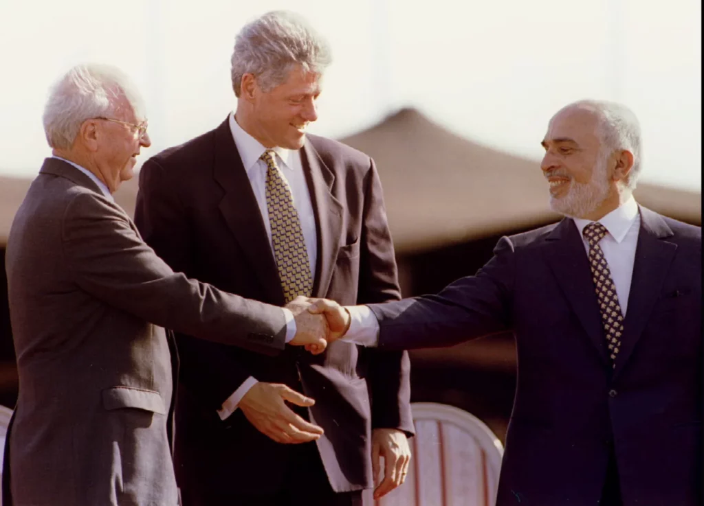
Le 26 novembre, le traité de paix séparée israélo-jordanien est signé en grande pompe dans la vallée de l’Arava, entre la mer Rouge et la mer Morte, par les Premiers ministres des deux pays, en présence du président américain Bill Clinton, dont le pays avait contribué à faire aboutir les négociations entre Jérusalem et Amman.
Apparaissent alors, fait rare, les conditions pour que la vieille idée de relier la mer Rouge à la mer Morte, un projet rebaptisé et soutenu par Shimon Peres sous le nom de « Canal de la paix », puisse revenir sur la table.
L’ancien commissaire israélien de l’eau, le professeur Dan Zaslavsky, qui s’opposait au projet pour des raisons de coût, relatait en 2006 dans le Jerusalem Post l’obstination de Peres. Pour écouter les scientifiques, ce dernier en avait convoqué cinq. Chacun devait présenter en quelques minutes ses objections. A la fin, Peres s’est levé et a dit : « Excusez-moi. Vous ne vous souvenez pas que j’ai construit le réacteur nucléaire de Dimona ? Vous souvenez-vous que tout le monde était contre ? Et bien j’ai eu raison à la fin. Et il en sera de même avec ce projet« . Et sur ce, rapporte Zaslavsky, Peres est parti !
La mer Morte
Pendant des millénaires, la mer Morte a été remplie d’eau douce provenant du Jourdain, via le lac de Tibériade. Or, au cours des cinquante dernières années, elle a perdu 28 % de sa profondeur et un tiers de sa surface. Son niveau d’eau baisse inexorablement, à un rythme moyen de 1,45 mètre par an. Sa forte salinité (plus de 27 %, alors que la moyenne des océans et des mers est de 2 à 4 %) et son niveau de 430 mètres en dessous du niveau de la mer, ont toujours fasciné les visiteurs et procuré des bienfaits thérapeutiques. D’une longueur de 51 km sur 18 km de large, elle est partagée entre Israël, la Jordanie et la Cisjordanie.
La surexploitation des ressources en eau en amont (aqueduc national en Israël, canal du Ghor en Jordanie), ainsi que l’exploitation des mines de potasse, sont à l’origine du désert de sable qui, si rien n’est fait, continuera à remplacer la mer Morte. Si la mer Morte a besoin du Jourdain, en amont, le Jourdain a besoin du lac de Tibériade, d’où son cours inférieur prend sa source. Ces dernières années, le lac a lui aussi subi des baisses drastiques de son niveau d’eau, ce qui a déclenché un cercle vicieux entre les trois systèmes (lac de Tibériade, fleuve Jourdain et mer Morte).
L’Aqueduc
En réponse, fin 2006, la Banque mondiale et l’Agence française de développement (AFD) ont aidé Israël et la Jordanie à concevoir un projet colossal visant à relier la mer Morte à la mer Rouge via un pipeline souterrain de 180 kilomètres, entièrement construit sur le territoire jordanien. Un accord tripartite entre Israéliens, Jordaniens et Palestiniens avait été signé en décembre 2013.


Le projet mer Rouge – Mer morte combine plusieurs éléments:
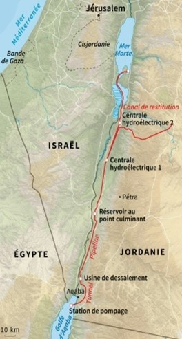
- Prise d’eau de mer et station de pompage
L’eau de mer est pompée à +125 m au-dessus du niveau de la mer dans la mer Rouge. - Conduite sous pression
La première partie du système d’adduction transmet l’eau de mer à l’altitude prévue. La longueur est de 5 km à partir d’Aqaba (3% de l’ensemble du tracé). - Canal et tunnel – le principal système d’adduction
L’eau de mer est acheminée vers des réservoirs de régulation et de prétraitement avec un débit nominal de 60 m3 /s. Un tunnel de 121 km avec un diamètre de 7 m et un canal de 39 km ont été conçus. - Réservoirs de régulation et de prétraitement
Plusieurs réservoirs ont été conçus à +107 m à Wadi G’mal à la marge sud-est de la mer Morte. - Usine de dessalement
Les usines de dessalement sont conçues pour être exploitées en utilisant le processus d’osmose inverse à support hydrostatique pour séparer l’eau douce de la saumure. L’usine sera située à Zafi, à 365 m au-dessous du niveau de la mer, avec une colonne d’eau de 475 m. - L’eau douce
L’ensemble produira chaque année environ 850 mmc d’eau douce à partager entre la Jordanie, Israël et la Palestine, les trois pays gérant la mer Morte. Pour le transport de l’eau vers Amman, un double pipeline de 200 km avec un diamètre de 2,75 m a été conçu avec neuf stations de pompage pour une élévation de 1500 m. Pour le transport vers Hébron, un double pipeline de 125 km avec une différence d’élévation de 1415 m a également été conçu. - La saumure
L’eau de rejet de la saumure sera acheminée de l’usine de dessalement vers la mer Morte via un canal de 7 km. 1 100 mmc par an d’eau de rejet de saumure rejoindront la mer Morte. - Production d’électricité
Lors de son écoulement, les turbines d’une ou de plusieurs centrales hydroélectriques permettent de générer environ 800 mégawatts d’électricité capables de compenser en partie l’électricité consommée par le pompage. - Trois nouvelles villes seront construites : North Aqaba city dans le nord d’Aqaba, South Dead Sea City, proche de l’usine de dessalement au sud de la mer Morte et South Amman City.
Compte tenu de l’importance stratégique de l’eau pour son économie, la Jordanie envisage d’y ajouter une centrale nucléaire permettant d’alimenter en électricité à la fois l’usine de dessalement et le système de pompage.
En termes d’impact environnemental, les scientifiques craignent que le mélange de la saumure (riche en sulfate) des usines de dessalement avec l’eau de la mer Morte (riche en calcium) ne fasse blanchir cette dernière. Il serait donc nécessaire de procéder à un transfert d’eau progressif pour observer les effets du transfert d’eau dans cet écosystème particulier.
Pas de quoi stabiliser le niveau de la mer Morte, mais un début de solution pour ralentir son assèchement, comme le soulignait en 2018 Frédéric Maurel, en charge de ce projet pour l’AFD, et pour qui « il faut aussi utiliser l’eau de manière plus économe, tant dans l’agriculture que dans l’industrie de la potasse ».
Volonté politique en panne

Du côté israélien, la sauvegarde de la mer Morte est une nécessité pour maintenir le tourisme balnéaire et le thermalisme. C’est aussi un levier pour garantir son contrôle hydraulique sur la Cisjordanie, Israël ne faisant pas confiance à l’Autorité palestinienne pour la gestion de l’eau. Conscientes du potentiel pacificateur de ce projet, des factions pro-paix en Israël ont besoin d’un partenaire stable dans la région. La Jordanie, pour sa part, était de loin la plus intéressée par ce projet, compte tenu de sa situation critique.
En 2021, la Jordanie a décidé de mettre un terme au projet de pipeline commun, estimant qu’il n’y avait « pas de réelle volonté de la part des Israéliens » de faire avancer ce projet qui stagnait depuis plusieurs années.
Pour faire face à ses besoins croissants, la Jordanie a décidé de construire sa propre usine de dessalement sur la mer Rouge. Le projet de dessalement Aqaba-Amman prélèvera l’eau de la mer Rouge, la dessalera et l’acheminera à 450 kilomètres au nord vers la capitale Amman et ses environs, fournissant ainsi 300 mmc d’eau par an, dont le pays a désespérément besoin. Les études sont terminées et la construction commencera en juillet 2024. La Jordanie compte faire tourner son usine de dessalement grâce à de l’énergie solaire.
La mer Morte pourrait lentement réapparaître

Disposant désormais d’énormes capacités de désalinisation, Israël a adopté le Projet national d’inversion du flux pour rendre l’eau à ses ressources naturelles, en particulier au lac de Tibériade, un trésor national, une pièce maîtresse du tourisme, de l’agriculture et, comme nous l’avons vu, de la géopolitique.
Chaque année, Israël prélève 100 mmc d’eau dans le lac de Tibériade pour les envoyer en Jordanie, et ce même pendant les années de sécheresse de 2013 à 2018.
Selon Dodi Belser, directeur de l’innovation chez le géant de l’eau Mekorot, si Israël veut augmenter la quantité d’eau qu’il envoie à ses voisins jordaniens et protéger ses réserves, il est vital de conserver le niveau d’eau du lac. C’est ainsi qu’est née l’idée de pomper de l’eau dessalée dans le lac de Tibériade, à hauteur de 120 mmc par an jusqu’en 2026.
Mécaniquement cette eau ira également alimenter le Jourdain et, par conséquent… la mer Morte. Rappelons que le sel de la mer Morte provient des eaux du Jourdain. Chaque année, le célèbre fleuve lui apporte près de 850 000 tonnes de sel.
F. Projets turcs
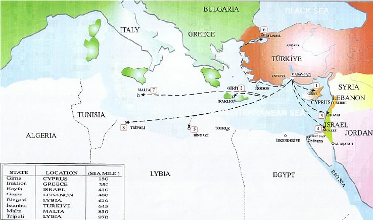
Depuis longtemps, la Turquie, véritable « château d’eau » dans la région, rêve d’exporter, à prix d’or, son eau vers Israël, la Palestine, Chypre et d’autres pays du Moyen-Orient.
Le plus ambitieux de ces projets était le « Peace Water Pipeline » du président Turgut Özal en 1986, un projet de 21 milliards de dollars visant à acheminer l’eau des rivières Seyhan et Ceyhan par des pipelines vers des villes de Syrie, de Jordanie et des États arabes du Golfe.
En 2000, Israël envisageait fortement d’acheter 50 millions de m3 par an pendant 20 ans à partir du fleuve Manavgat près d’Antalya, mais depuis novembre 2006, l’accord a été mis en suspens.

Le projet Manavgat, finalisé techniquement à la mi-mars, fait figure de projet pilote. Le complexe sur la rivière Manavgat, qui prend sa source dans le Taurus pour se jeter en Méditerranée entre Antalya et Alanya, comprend une station de pompage, un centre de raffinage et un canal de conduite d’une dizaine de kilomètres. L’objectif est ensuite d’acheminer ces eaux douces grâce à des tankers de 250 000 tonnes vers le port israélien d’Ashkelon pour injection dans l’aqueduc national israélien.
A terme, la Jordanie pourrait également être intéressée par la manne aquatique turque. Un deuxième client en aval de son réseau permettrait à Israël de partager les coûts. Une autre solution serait d’amener l’eau par un pipeline reliant la Turquie à la Syrie et à la Jordanie, et à Israël et la Palestine si elle arrive à s’entendre avec ses partenaires. Les Palestiniens de leur côté ont cherché un pays donateur pour subventionner des importations d’eau douce par tanker.
Le projet Manavgat n’est pas le seul par lequel Ankara espère vendre son eau. En 1992, Süleyman Demirel, alors Premier ministre, affirmait un principe qui fit d’ailleurs l’effet d’une bombe :
« La Turquie peut utiliser comme elle l’entend les eaux du Tigre et de l’Euphrate : les ressources hydrauliques de la Turquie appartiennent à la Turquie comme le pétrole appartient aux pays arabes. »
Les pays situés en aval des deux fleuves, l’Irak et surtout la Syrie, avaient immédiatement protesté. Pour eux, les multiples barrages qu’Ankara compte construire sur les principales sources d’eau douce de la région, à des fins d’irrigation ou de production d’électricité, ne sont qu’une manière pour l’héritier de l’Empire ottoman d’asseoir son autorité sur la région.
Quelle que soit l’ambition réelle d’Ankara, le pays dispose en tout cas d’un véritable trésor, surtout au regard des ressources déclinantes des pays voisins.
Cependant, depuis novembre 2006, les partisans israéliens du dessalement s’élèvent contre le prix de l’eau turque et s’interrogent sur la sagesse de s’appuyer sur Ankara, dont le gouvernement critique les politiques israéliennes. Dessalement ou importation ? Le choix est cornélien pour Israël. Et éminemment politique, puisqu’il s’agit de savoir si l’on entend camper sur des positions basées sur l’autosuffisance ou si l’on préfère jouer la carte de la coopération régionale, ce qui revient à faire le pari de la confiance…
G. Vices cachés des accords d’Oslo
La reconnaissance d’Israël par Yasser Arafat – chef de l’Organisation de libération de la Palestine – et l’élection d’Yitzhak Rabin au poste de Premier ministre d’Israël en 1992 ont ouvert de nouvelles perspectives de paix et de coopération.
Les accords d’Oslo qu’ils ont signés ont établi l’Autorité palestinienne et déterminé les allocations temporaires d’eau souterraine de la Cisjordanie à Israël et à la Palestine. Dans la déclaration, les deux parties ont accepté le principe d’une « utilisation équitable » entre Palestiniens et Israéliens.
Cependant, l’effondrement de la confiance mutuelle à la suite de l’assassinat de Rabin en novembre 1995 et l’élection de Benjamin Netanyahou, qui s’était montré très critique à l’égard d’Oslo, ont eu des répercussions négatives sur la coopération dans le domaine de l’eau.
En 2000, pendant les six premiers mois de la seconde Intifada, il n’y a eu pratiquement aucun contact entre les deux parties concernant les questions liées à l’eau.
Malgré le conflit, mettant de coté leurs désaccords, les dirigeants israéliens et palestiniens se sont engagés à séparer la question de l’eau de la violence et ont réactivé la coopération sur l’eau.
En 2004, Israël aurait proposé un plan de construction d’une usine de dessalement afin d’augmenter la quantité d’eau douce disponible et d’acheminer l’eau dessalée vers la Cisjordanie. Craignant que cela n’implique un renoncement aux revendications palestiniennes sur l’aquifère de la montagne (dont 75 % sont attribués à Israël bien que l’aquifère se trouve en territoire palestinien), les Palestiniens ont rejeté cette solution.
Bien que stipulant qu’« Israël reconnaît les droits sur l’eau de la Palestine », les accords d’Oslo, signés par Israël et l’Organisation de libération de la Palestine (OLP) en 1993, ont permis en réalité à Israël de continuer de contrôler les sources d’eau de la région… en attendant la résolution du conflit. Oslo II prévoyait le report des négociations sur les droits relatifs à l’eau jusqu’aux pourparlers sur le « statut permanent », le statut de Jérusalem, le droit au retour des réfugiés, les colonies illégales, les dispositions en matière de sécurité et d’autres questions. Les discussions sur le statut définitif, qui devaient se tenir cinq ans après la mise en œuvre des accords d’Oslo (en 1999, comme cela avait été prévu), n’ont toujours pas eu lieu à ce jour.
Les accords d’Oslo prévoyaient également la création d’une autorité de gestion de l’eau et leur « Déclaration de principes » soulignait la nécessité d’assurer « l’utilisation équitable des ressources en eau communes, pour application au cours de la période intérimaire [des accords d’Oslo] et après ».
Depuis des décennies, Israël perpétue le principe de distribution de l’eau qui existait avant la signature des accords d’Oslo et qui autorise les Israéliens à consommer de l’eau à volonté, tout en limitant les Palestiniens à une part prédéterminée de 15 %.
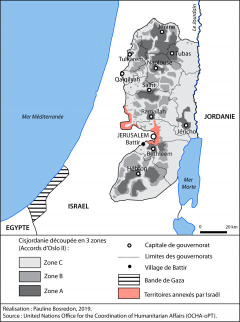
Lorsqu’il a fallu organiser la répartition de l’eau entre Israël et les Palestiniens, les accords n’ont pas tenu compte de la division de la Cisjordanie en zones A, B et C.
Israël s’est finalement vu accorder le droit de contrôler les sources d’eau, même dans les zones A et B contrôlées par l’AP. La plupart de ces sources sont déjà situées en zone C, entièrement contrôlée par Israël et qui constitue près de 61 % de la Cisjordanie. Dans les faits, Israël a donc raccordé toutes les colonies construites en Cisjordanie, à l’exception de la vallée du Jourdain, au réseau d’eau israélien. L’approvisionnement en eau des communautés israéliennes de part et d’autre de la ligne verte est géré comme un système unique dont la compagnie nationale israélienne Mekorot a la charge.
Si les accords d’Oslo autorisent Israël à pomper l’eau des zones qu’il contrôle pour alimenter les colonies de Cisjordanie occupée, ils empêchent en revanche l’AP de transférer de l’eau d’une zone à l’autre dans celles qu’elle administre en Cisjordanie. Israël a désavoué la plupart des dispositions des accords d’Oslo, mais reste attachée à celles relatives à l’eau.
Un membre de la délégation palestinienne qui a signé les accords d’Oslo, souhaitant conserver l’anonymat, affirme à la revue Middle East Eye que le manque d’expertise de la délégation à l’époque a donné lieu à la signature d’un accord qui,
« plaçait le sort de l’accès des Palestiniens à l’eau entre les mains d’Israël (…) La plupart des experts palestiniens en eau se sont retirés des négociations dès le début du processus d’Oslo, car ils n’étaient pas satisfaits de la manière dont les négociations étaient menées, déplore-t-il. Quant aux responsables politiques, leur principal objectif était de parvenir à un accord. »

En pratique, cela signifie que les Palestiniens de Cisjordanie occupée sont à la merci de l’occupation israélienne en ce qui concerne leur approvisionnement en eau.
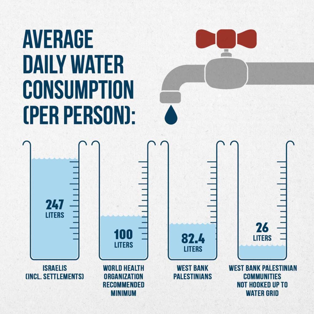
Les inégalités en termes d’accès à l’eau en Cisjordanie sont criantes, comme l’a montré l’ONG israélienne B’Tselem dans un rapport intitulé Parched, publié en mai 2023.
En 2020, chaque Palestinien de Cisjordanie consommait en moyenne 82,4 litres d’eau par jour, contre 247 litres par personne en Israël et dans les colonies. Ce chiffre tombe à 26 litres par jour pour les communautés palestiniennes de Cisjordanie qui ne sont pas reliées au réseau de distribution d’eau. Seuls 36 % des Palestiniens de Cisjordanie bénéficient d’un accès à l’eau courante toute l’année, contre 100 % des Israéliens, colons inclus.
L’Autorité palestinienne souligne que l’agriculture palestinienne compte pour une grande part dans l’économie des territoires occupés (15% du PIB, 14% de la population active en 2000). En comparaison, l’agriculture israélienne, certes beaucoup plus productive, emploie 2,5% de la population active et produit 3% du PIB.
Or, les terres cultivables dont l’autonomie palestinienne, totale ou partielle, est reconnue par Israël au titre des accords d’Oslo, sont situées sur les hauteurs calcaires où l’accès à l’eau est difficile, puisqu’il est nécessaire de creuser profond pour atteindre la nappe. Ajoutons à cela qu’en Israël et dans les colonies, 47% des terres sont irriguées, contre 6 % seulement des terres palestiniennes. L’Autorité palestinienne demande actuellement des droits sur 80 % de l’aquifère des montagnes, ce qu’Israël ne peut pas concevoir.
« Mythe » du Palestinien assoiffé
Des porte-parole israéliens, comme Akiva Bigman dans son article intitulé « Le mythe du Palestinien assoiffé » (2014), ont trois réponses prêtes à sortir lorsqu’ils sont confrontés aux pénuries d’eau dans les villes palestiniennes de Cisjordanie :
1) « Parce que l’Autorité palestinienne n’entretient pas correctement son système d’approvisionnement en eau, elle souffre d’un taux de perte d’eau de 33 %, principalement dû aux fuites, alors que le système israélien ne perd que 11 % de son eau ».
Réponse : les pertes varient de 20 à 50 % aux États-Unis, ce qui est bien supérieur au taux de la Palestine pauvre.
2) « 40 sites de forage potentiels dans la région d’Hébron ont été identifiés et approuvés par le Comité conjoint israélo-palestinien sur l’eau ; mais au cours des deux décennies qui se sont écoulées depuis, le forage n’a eu lieu qu’à trois endroits, et ce malgré les fonds substantiels accordés à l’Autorité palestinienne par les pays donateurs ».
On peut se demander où est passé l’argent. Et oui, le constat est juste, au bout du compte, pour diverses raisons techniques et des échecs de forage inattendus dans le bassin oriental de l’aquifère (le seul endroit où l’accord autorise les Palestiniens à forer), les Palestiniens ont fini par produire moins d’eau que ce que prévoyaient les accords.
3) Dans sa grande générosité, Israël a « doublé la quantité d’eau qu’il fournit aux Palestiniens, par rapport à ce qui était prévu dans les accords d’Oslo ».

Dans les chiffres, c’est vrai. Cependant, Oslo n’a pas fixé de limite à la quantité d’eau qu’Israël peut prélever, mais a limité les Palestiniens à 118 mmc provenant des puits qui existaient avant les accords, et à 70-80 mmc supplémentaires provenant de nouveaux forages. Selon l’ONG israélienne B’Tselem, en 2014, les Palestiniens ne tiraient que 14 % de l’eau de l’aquifère. C’est pourquoi l’entreprise publique israélienne Mekorot (obéissant aux directives du gouvernement) vend aux Palestiniens le double de l’eau stipulée dans l’accord d’Oslo : 64 MCM, contre 31 MCM prévus. Cela fait 64 + 31 = 95 MCM au total, un chiffre à examiner à la lumière de la consommation actuelle des Palestiniens de Cisjordanie : 239 mcm en 2020, dont… 77,1 achetés à Israël.
Un dernier détail qui en dit long : alors que les Palestiniens sont facturés au prix de l’eau potable pour leur eau agricole, les colons Juifs bénéficient de tarifs agricoles et de subventions. La justification étant que les colons juifs ont investi dans de coûteuses techniques d’irrigation…
H. Canal de navigation Ben Gourion
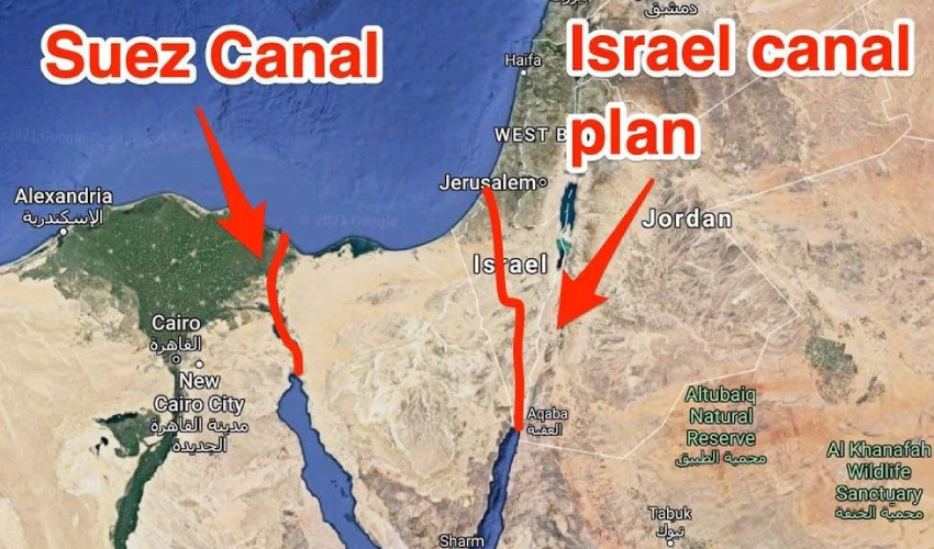
Fin 2023, l’idée du canal Ben Gourion fut relancée dans les médias. Ce canal relierait le golfe d’Aqaba (Eilat), dans la mer Rouge, à la mer Méditerranée et passerait par Israël pour se terminer dans ou près de la bande de Gaza (Ashkelon).
Il s’agit d’une alternative israélienne au canal de Suez, devenue d’actualité dans les années 1960 après la nationalisation de Suez par Nasser.
Les premières idées de connexion entre la mer Rouge et la Méditerranée sont apparues au milieu du XIXe siècle, à l’initiative des Britanniques qui souhaitaient relier les trois mers : Rouge, Morte et Méditerranée. La mer Morte se trouvant à 430 mètres en dessous du niveau de la mer, cette idée n’était pas réalisable, mais on pourrait l’adapter dans une autre direction. Effrayés par la nationalisation de Suez par Nasser, les Américains envisagent l’option du canal israélien, leur fidèle allié au Moyen-Orient.
En juillet 1963, H. D. Maccabee, du Lawrence Livermore National Laboratory (sous contrat avec le ministère américain de l’Energie), rédige un mémorandum explorant la possibilité de recourir à 520 explosions nucléaires souterraines pour creuser environ 250 kilomètres de canaux à travers le désert du Néguev. Classé secret jusqu’en 1993, ce document aujourd’hui déclassifié indique :
« Ce canal constituerait une alternative stratégiquement valable à l’actuel canal de Suez et contribuerait probablement grandement au développement économique de la région environnante. »
L’idée du canal Ben Gourion est réapparue au moment où ont été signés les accords dits « d’Abraham » entre Israël et les Émirats arabes unis, le Bahreïn, le Maroc et le Soudan. Le 20 octobre 2020, l’impensable s’est produit : l’entreprise publique israélienne Europe Asia Pipeline Company (EAPC) et la société émiratie MED-RED Land Bridge ont signé un accord sur l’utilisation de l’oléoduc Eilat-Ashkelon pour transporter du pétrole de la mer Rouge à la Méditerranée, donc sans passer par le canal de Suez.
Le 2 avril 2021, Israël annonça que les travaux sur le canal Ben Gourion devaient commencer en juin de la même année, mais ce ne fut pas le cas.
Les promoteurs du projet avancent que leur canal serait plus efficace que le canal de Suez car, en plus de pouvoir accueillir un plus grand nombre de navires, il permettrait la navigation simultanée dans les deux sens de grands navires grâce à la conception en deux bras. Contrairement au canal de Suez, qui s’écoule entre des rives sablonneuses, le canal israélien aurait des parois en dur ne nécessitant presque pas d’entretien. Israël prévoit de construire de petites villes, des hôtels, des restaurants et des cafés tout le long du canal.
De nombreux analystes interprètent la réoccupation israélienne actuelle de la bande de Gaza comme un événement que de nombreux politiciens israéliens attendaient pour relancer un vieux projet.
Chaque branche proposée du canal aurait une profondeur de 50 mètres et une largeur d’environ 200 mètres. Il serait 10 mètres plus profond que le canal de Suez. Des navires de 300 mètres de long et 110 mètres de large pourraient l’emprunter, ce qui correspond à la taille des plus grands navires du monde.

Si l’on examine plus en détail le tracé prévu, on constate que le canal commence à la limite sud du golfe d’Aqaba, à partir de la ville portuaire d’Eilat, près de la frontière israélo-palestinienne, et se prolonge à travers la vallée de l’Arabah sur environ 100 km, entre les montagnes du Néguev et les hauts plateaux jordaniens.
Il bifurque ensuite vers l’ouest avant la mer Morte, continue dans une vallée de la chaîne montagneuse du Néguev, puis tourne à nouveau vers le nord pour contourner la bande de Gaza et rejoindre la mer Méditerranée dans la région d’Ashkelon.
S’il est réalisé, avec ses 292,9 km de long, le canal Ben Gourion sera presque un tiers plus long que le canal de Suez (193,3 km). Sa construction prendrait 5 ans et impliquerait 300 000 ingénieurs et techniciens du monde entier. Le coût de la construction est estimé entre 16 et 55 milliards de dollars. Israël devrait gagner 6 milliards de dollars par an.
Celui qui contrôlera le canal, et apparemment ce ne peut être qu’Israël et ses alliés (principalement les États-Unis et la Grande-Bretagne), aura une influence énorme sur les chaînes d’approvisionnement internationales de pétrole, gaz, céréales, mais aussi sur tout le commerce mondial en général.
Israël avance qu’un tel projet mettrait en échec le pouvoir de l’Egypte, un pays fortement allié à la Russie, à la Chine et aux BRICS, et donc « une menace » pour les Occidentaux ! Avec la dépopulation de Gaza et la perspective d’un total contrôle israélien sur ce minuscule territoire, certains politiciens israéliens, y compris Netanyahou, salivent de nouveau à la perspective d’un tel projet.
Comme le précise en novembre 2023 l’analyste croate Matia Seric dans Asia Review :
« S’il était réalisé, le canal Ben Gourion entraînerait un changement tectonique en éclipsant le canal de Suez. Le projet propulsera Israël au centre de la navigation et du commerce mondiaux. L’Égypte perdrait son monopole sur la route la plus courte entre l’Afrique, l’Asie et l’Europe. L’émergence d’un canal israélien alternatif aurait un impact dévastateur sur l’économie égyptienne.
Le président Al-Sissi pourrait regretter d’avoir placé sa confiance en Israël et dans les gouvernements occidentaux au-dessus du bien-être des deux millions de Palestiniens de Gaza. L’Égypte, à part la condamnation formelle des crimes de masse commis par les forces israéliennes contre la population civile palestinienne, n’a pas fait grand-chose pour empêcher les méfaits israéliens, que certains qualifient de génocide.
Le Premier ministre israélien Benjamin Netanyahou a exprimé à plusieurs reprises son soutien à l’idée du canal, ainsi qu’à celle de la construction d’une ligne ferroviaire à grande vitesse entre Eilat et Beersheba.
La réalisation, ou du moins le lancement, de ce projet pourrait racheter Netanyahou des nombreuses erreurs qu’il a commises au cours de son long règne, y compris les échecs en matière de renseignement et sur le plan militaire qui ont facilité l’attaque du 7 octobre par le Hamas. »
I. Plan Oasis
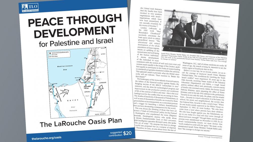
C’est à la lumière de tous ces échecs qu’apparaît l’apport fondamental du « Plan Oasis » proposé par l’économiste américain Lyndon LaRouche (1922-2019).
En 1975, à la suite d’entretiens avec les dirigeants du parti Baas irakien et du parti travailliste israélien, Lyndon LaRouche voyait son plan Oasis comme le socle d’un développement mutuel bénéficiant à toute la région.
Au lieu d’attendre « la stabilité » et « une paix durable » qui arriveraient par magie, il s’agit alors pour LaRouche de proposer et même de lancer des projets dans l’intérêt de tous, en recrutant tous les partenaires à y participer pleinement, avant tout dans leur propre intérêt, mais en réalité dans l’intérêt de tous.

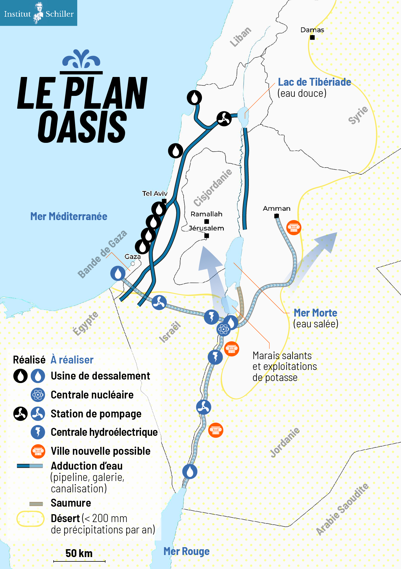
Le Plan Oasis* pour une « paix bleue », conçu par LaRouche et défendu par l’Institut Schiller, prévoit :
- L’abandon par Israël de son contrôle exclusif des ressources en eau, au profit d’un accord de partage équitable des ressources entre tous les pays de la région ;
- La reconstruction et le développement économique de la bande de Gaza, y compris l’Aéroport international Yasser Arafat (inauguré en 1998 et détruit au bulldozer par les Israéliens en 2002), un grand port maritime desservant un hinterland équipé d’infrastructures de transport, industrielles et agricoles.
- L’installation immédiate d’une usine de dessalement flottante, sous-marine ou off-shore, sur la côte de Gaza.
- La construction d’un réseau ferroviaire moderne pour le transport rapide des personnes et le fret, reliant la Palestine (y compris Gaza) et Israël aux pays voisins.
- La réalisation (pour moins de 20 milliards de dollars) d’un système d’adduction d’eau Méditerranée-mer Morte et mer Rouge-mer Morte, composé de tunnels, pipelines, galeries d’eau, stations de pompage, unités hydroélectriques et usines de dessalement fonctionnant à l’énergie nucléaire.
- Avant d’être dessalée, l’eau de mer arrivant à la mer Morte « chutera » dans un puits de 400 mètres de profondeur (le niveau de la mer Morte), produisant ainsi de l’hydroélectricité.
- Après dessalement, l’eau douce ira en Jordanie, en Palestine et en Israël ; la saumure ira remplir et sauver la mer Morte.
- L’unité nucléaire de « dessalement hybride » fera appel aussi bien à la chaleur qu’à l’électricité produite par le réacteur.
- La chaleur industrielle des réacteurs à haute température (HTR) servira à des applications industrielles et agricoles.
- L’ensemble des réservoirs fonctionnera également comme un système de transfert d’énergie par pompage (STEP), indispensable pour réguler les réseaux électriques de la région.
- Une partie de l’eau de mer transitant par le système d’adduction Méditerranée-mer Morte sera dessalée à Beersheba, la « capitale du Néguev » dont la population, grâce à de nouvelles réserves d’eau douce, pourra doubler.
- De nouvelles villes et des « corridors de développement » se développeront autour des nouveaux systèmes d’adduction d’eau.
- Le centre de recherche nucléaire et la centrale de Dimona (pour l’instant un réacteur à but militaire et de traitement de déchets nucléaires du secteur médical) peuvent constituer la base d’un programme nucléaire civil israélien et contribueront à la construction d’usines de dessalement nucléaire. La Jordanie peut y contribuer avec ses réserves en thorium et en uranium.
- Des plan américains et israéliens existent pour accueillir 500 000 à 1 million d’habitants supplémentaires dans le Néguev. Pour nous, ces plans doivent être entièrement reconfigurés et ne peuvent en aucun cas se résumer à une simple extension de colonies exclusivement juives. Ils doivent offrir l’occasion à tous les citoyens israéliens, en coopération avec Bédouins qui y vivent (200 000 ou 30% du total), les Palestiniens et d’autres, de faire reculer un ennemi commun : le désert.
- La fin de la politique de colonisation illégale en Cisjordanie. Les colons seront incités (fiscalité, etc.) à se réorienter vers le Néguev où ils pourront occuper, en bonne entente avec les Bédouins, des Palestiniens et d’autres, des emplois productifs et y faire fleurir le désert (62 % du territoire israélien).
PS: Ce plan cherche à promouvoir la paix par le développement mutuel. Il est à l’opposé du projet de canal Ben Gourion, un plan mégalomaniaque défendu par Netanyahou, visant à créer un canal de navigation de la mer Rouge à la Méditerranée pour concurrencer le canal de Suez.

6. Alvin Weinberg, Yitzhak Rabin et Lyndon LaRouche
LaRouche proposait de combiner les infrastructures hydrologiques, énergétiques, agricoles et industrielles. Il donna aux complexes agro-industriels construits autour de petits réacteurs nucléaires à haute température le nom de « nuplexes », un concept avancé dans l’après-guerre par le scientifique américain Alvin Weinberg, grand patron des laboratoires d’Oak Ridge au Tennessee (ORNL) et co-inventeur de plusieurs types de réacteurs nucléaires, notamment la filière aux sels fondus utilisant le thorium comme combustible (donc sans production de plutonium militaire).
Au chapitre 8 de son autobiographie, Weinberg raconte comment l’ORNL « s’est lancé dans une grande entreprise : dessaler la mer avec de l’énergie nucléaire bon marché », avec des centrales « à usage multiple, produisant à la fois de l’eau, de l’électricité et de la chaleur industrielle ». L’affirmation que cela était possible, rapporte Weinberg, « a suscité des remous au sein de la Commission de l’énergie atomique ».
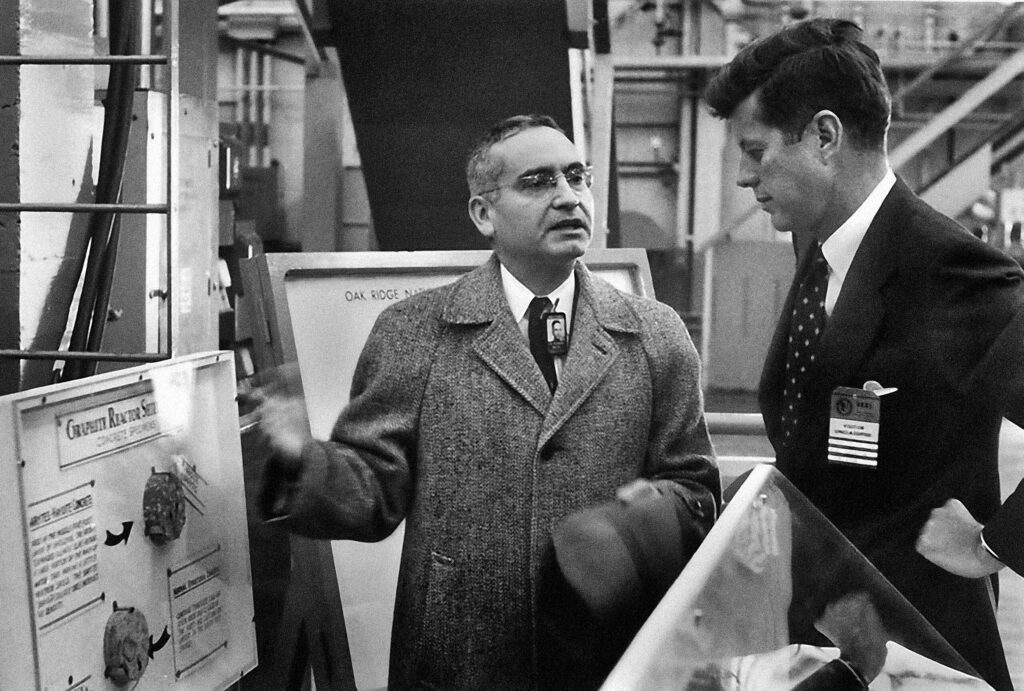
Finalement, c’est le président Kennedy qui s’est montré le plus enthousiaste, en s’exprimant le 25 septembre 1963 :
« Nous examinons aujourd’hui aux États-Unis la question économique et technique, de savoir si les réacteurs nucléaires peuvent produire des économies inattendues dans le dessalement simultané de l’eau et la production d’électricité. Avant la fin de cette décennie au plus tard, nous disposerons d’un énorme réacteur nucléaire qui produira de l’électricité et, en même temps, de l’eau douce à partir d’eau salée à un prix compétitif (…) pas seulement aux États-Unis, mais partout dans le monde où il y a tant de déserts au bord de l’océan. »
L’idée parvint ensuite à l’oreille du patron de la Commission de l’énergie atomique (AEC), Lewis Strauss.
« C’était en 1967, juste après la guerre des Six-Jours, et le Moyen-Orient était au centre de nos préoccupations. Le problème ultime du Moyen-Orient est l’eau – un point qui est aujourd’hui peut-être plus reconnu qu’il ne l’était en 1967. Pourquoi ne pas construire des usines de dessalement nucléaires et électriques à double usage en Égypte, en Israël et en Jordanie – faire littéralement fleurir les déserts – et créer ainsi une nouvelle possibilité majeure de règlement du conflit israélo-arabe ? »
Lewis transmet cette idée à Eisenhower, qui esquisse dans le magazine Life les grandes lignes de ce qui sera connu sous le nom de plan Eisenhower, basé « sur ce dont Lewis et moi avions discuté », écrit Weinberg.
Celui-ci envoie alors une équipe en Égypte, en Israël et au Liban, où elle fut chaleureusement accueillie. Cette visite permit à Tennessee d’inviter des ingénieurs israéliens et égyptiens à s’intégrer dans le projet d’étude du Moyen-Orient « qui étudiait ce que nous appelions les ‘complexes agro-industriels à propulsion nucléaire+’ ».
Le « projet Moyen-Orient » a adapté ces résultats antérieurs à la situation israélo-égyptienne. Un rapport en fut publié en plusieurs volumes, « dans lequel nous avons examiné la faisabilité de complexes nucléaires agro-industriels à construire en tant que projets nationaux dans la région d’El-Hamman, près d’Alexandrie en Égypte, et dans la région occidentale du Néguev en Israël, et en tant que projet international près de la bande de Gaza. L’implication était que les complexes seraient subventionnés par les États-Unis.
« J’ai rencontré l’ambassadeur d’Israël de l’époque, Yitzhak Rabin, pendant environ une heure à l’aéroport de Knoxville pour lui faire part de nos résultats. Rabin, qui est devenu Premier ministre d’Israël, était sceptique – tant sur la faisabilité politique d’un projet mené conjointement par des Israéliens et des Arabes que sur la faisabilité économique d’une entreprise d’une telle ampleur. Mais surtout, il suggéra que nous avions un culot extraordinaire, nous autres, assis dans le Tennessee, pour mettre au point un projet visant à résoudre un conflit ethnique amer à quelque six mille kilomètres de là ! Bien sûr, Rabin avait raison sur les deux points, mais je n’ai pas pu m’empêcher de dire : ‘Mais, Monsieur l’Ambassadeur, le fait que nous élaborions dans le Tennessee des plans pour des complexes agro-industriels au Moyen-Orient, est-il plus stupide que le fait que Théodore Herzl élaborait des plans pour Israël dans un café de Vienne en 1896 ?’ »
« Le plan Eisenhower-Baker n’a jamais été mis en œuvre : la volonté politique nécessaire pour soutenir la construction de grands réacteurs dans un Moyen-Orient en proie aux conflits faisait défaut… », regretta Weinberg, qui ignorait les opérations des frères Dulles…
Le plan LaRouche, comme tant d’autres propositions allant dans le même sens, a été bloqué jusqu’ici du côté israélien, américain et britannique, et nous ne savons que trop bien ce qui est arrivé à Yitzhak Rabin, assassiné après avoir signé les accords d’Oslo, à Shimon Peres évincé, et à un Yasser Arafat diabolisé. A cela il faut ajouter que LaRouche fut couvert de calomnies et traité d’antisémite.
Le 13 avril 2034, le plan Oasis de LaRouche et sa pertinence pour aujourd’hui ont été discutés et débattus lors d’une conférence internationale de zoom et approuvés par plusieurs ambassadeurs et diplomates de haut niveau de Palestine, d’Afrique du Sud, de Russie et de Guyane.
Des événements similaires sont en cours de préparation par l’Institut Schiller pour poursuivre la discussion et faire de ce rêve une réalité.
Israel-Palestine: Time to Make Water a Weapon for Peace

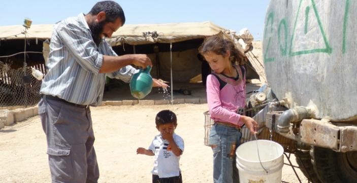
« If we solve all the problems in the Middle East,
but not the problem of sharing water, our region will explode.
Peace will not be possible »
(Yitzhak Rabin, former Israeli Prime Minister, 1992).
« You only make peace with your enemies. »
(Yitzhak Rabin.)
Contents:
Introduction
1. Geography of the Middle East
2. Rainfall and Water resources
3. Hydrography of the Jordan basin
A. Source
B. Tributaries
C. Lake of Tiberias
D. Yarmouk river
4. Water sources for Israel-Palestine
A. Surface water
B. Groundwater
C. Desalination
D. Reuse of Waste water
5. Water Infrastructure Projects
A. National Water Carrier (NWC)
B. Johnston Plan
C. Ghor Canal
D. Med – Dead Sea aqueduct
E. Red Sea – Dead Sea Water Conveyance
F. Turkish projects
G. Hidden defects and non-application of the Oslo agreements
H. Ben-Gurion Canal
I. Oasis Plan
J. Alvin Weinberg, Yitzhak Rabin and Lyndon LaRouche
Introduction
This article provides readers with the keys. To understand the history of the water wars that continue to ravage the Middle East, it is essential to understand the geological, hydrographical, geographical and political issues at stake. In the second part, we examine the various options for developing water resources as part of a strategy to overcome the crisis. We will deal with the gas issue, another subject of potential conflict or cooperation, in a later article.
1. Geography
The Jordan River basin is shared by four countries: Lebanon, Syria, Jordan and Israel, plus the Palestinian territories of the West Bank and Gaza.
Situated in the hollow of a tectonic depression on the great fault that runs from Aqaba to Turkey, the Jordan Valley is one of the lowest-lying basins in the world, flowing into the Dead Sea at an altitude of 421 meters below sea level.
See interactive topographic map.
Added to this is the fact that this is an endorheic basin, i.e. a river that flows neither into the sea nor the ocean. As in the Aral Sea basin in Central Asia, this means that any water drawn or diverted upstream reduces the level of its ultimate receptacle, the Dead Sea (see below), and can even potentially make it disappear.
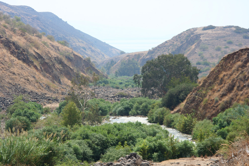
While remaining a fundamental artery for the entire region, the Jordan River has a number of drawbacks: its course is not navigable, its flow remains low and its waters, which are highly saline, are polluted.
As one of the key factors in the « Water, Energy, Food nexus » – three factors whose interdependence is such that we can’t deal with one without dealing with the other two – water resource management remains a key issue, and holds a primordial place for any future shared between Israel and its Arab neighbors. To grow food, one needs water. But to desalinate sea water, Israel spends 10 % of its electricity generated by consuming gas and oil.
2. Rainfall and water resources
The Middle East forms a long, arid strip, only accidentally interrupted by areas of abundant rainfall (around 500-700 mm/year), such as the mountains of Lebanon, Palestine and Yemen.
Geographically, much of the Middle East lies south of the isohyet (imaginary line connecting points of equal rainfall) indicating 300 mm/year.
However, precipitation has only a limited effect due to its seasonality (October-February).
As a result, river flow and flooding are irregular throughout the year, as well as between years. The same applies to groundwater recharge.
On a state-by-state basis, total water resources are very unevenly distributed in the region:
—Turkey and Iraq have over 4,000 cubic meters per person per year, and Lebanon around 3000 m³/person/year, which is above the regional average (1,800 m³/person/year).
—Syria and Egypt have around 1200 m³/person/year, one third lower.
On the other hand, some countries are below the critical 500 m³/year/capita bracket:
—Israel and Jordan have 300 m³/year/capita, and the Palestinian Territories (West Bank-Gaza) less than 200 m³/year/capita. They are in what the World Health Organization (WHO) calls a situation of « water stress ».
The Middle East enjoys plenty of water on a regional scale, but has many areas in chronic shortage, on a local scale.
3. Hydrography of the Jordan basin
A. Source
360 km long, the Jordan River rises from water flowing down the slopes of Jabal el-Sheikh (Mount Hermon) in southern Lebanon on the border with Syria.
B. Tributaries
Once over the Israeli border, three tributaries join the Jordan about 6 kilometers upstream from the former Lake Hula (now reclaimed):
1. The Hasbani, with a flow of 140 million cubic meters (MCM) per year, rises in Lebanon, a country it crosses over 21 kilometers. The upper reaches of the Hasbani vary greatly with the seasons, while the lower reaches are more regular.
2. The Banias, currently under Israeli control and 30 kilometers long, has an annual flow close to that of the Hasbani (140 MCM). It rises in Syria in the Golan Heights, and flows into Israel for around 12 kilometers before emptying into the Upper Jordan.
3. The Nahr Leddan (or Dan) forms in Israel when the waters of the Golan Heights come together. Although restricted, its course remains stable and its annual flow is greater than that of the other two tributaries of the Upper Jordan, exceeding 250 MCM per year.
C. Lake Tiberias or Kinneret (aka Sea of Galilee)
The Jordan then flows through 17 km of narrow gorges to reach Lake Tiberias, where the salinity is high, especially as the freshwater streams flowing into it have been diverted. Lake Tiberias, however, receives water from the many small streams running through the Golan Heights.
D. Yarmouk River
Next, the Jordan meets the Yarmouk River (bringing in water from Syria), then meanders for 320 km (109 km as the crow flies) to reach the Dead Sea. These 320 km are occupied by a humid plain (the humid zor), with subtropical vegetation, dominated on both sides (West Bank and Jordanian) by dry, gullied terraces.
4. Water sources for Israel
The Hebrew state has four main sources of water supply:
A. Surface Water
Israel benefits first and foremost from the freshwater reserves of Lake Tiberias in Galilee, in the north of the country. Crossed by the Jordan River, this small inland sea accounts for 25% of Israel’s water needs. The annexation of the Golan Heights and the occupation of southern Lebanon have made this source of water a sanctuary.
B. Groundwater
In addition to surface water (lakes and rivers), the country can rely on its coastal aquifers, from Haifa to Ashkelon.
Located between Israel and the occupied West Bank, the main aquifer, the Yarkon-Taninim mountain aquifer, has a capacity of 350 MCM per year. In the northeast and east of the West Bank are two other aquifers with capacities of 140 and 120 MCM per year respectively.
C. Seawater desalination
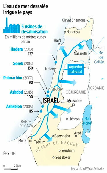
Five desalination plants built along the country’s coastline — in Ashkelon (2005), Palmachin (2007), Hadera (2010), Sorek (2013) and Ashdod (2015) — currently operate and two more are under construction. Collectively, these plants are projected to account for 85-90 per cent of Israel’s annual water consumption, marking a remarkable turnaround.
The Sorek desalination plant, located about 15 km south of Tel Aviv, became operational in October 2013 with a seawater treatment capacity of 624,000m³/day, which makes it world’s biggest seawater desalination plant. The desalination facility uses seawater reverse osmosis (SWRO) process providing water to Israel’s National Water Carrier system (NWC, see below). A dozen more units of this type are considered for construction.
Israel, which has been facing severe droughts since 2013, even began pumping desalinated seawater from the Mediterranean into Lake Tiberias, a unique performance worldwide. While Israel faced water scarcity two decades ago, it now exports water to its neighbors (not too much to Palestine). Israel currently supplies Jordan with 100 MCM and fulfills 20 % of Jordan’s water needs.

From 100 liters of seawater, 52 liters of drinking water and 48 liters of brine (brackish water) can be obtained. Although highly efficient and useful, desalination technology has still to be perfected, as it currently discharges brine into the sea, disrupting the marine ecosystem. To reduce this pollution and transform it into solid waste, we need to increase treatment and therefore energy consumption.
D. Wastewater
The country prides itself on reusing between 80% and 90% of its wastewater for agriculture. Treated wastewater used for irrigation is known as effluent. Israel’s effluent utilization rate is one of the highest in the world. Reclamation is carried out by 87 large wastewater treatment plants (WWTPs) that supply over 660 MCM per year. This represents around 50% of total water demand for agriculture and around 25% of the country’s total water demand. Israel aims to more than double the amount of effluent produced for the agricultural sector by 2050.
5. Water infrastructure projects
For Israel, acquiring water resources in a desert region, through technology, military conquest and/or diplomacy, was from the outset an imperative to meet the needs of a rapidly growing population and, in the eyes of the rest of the world, a demonstration of its sovereign power and its superiority.
This symbolism is particularly evident in the figure of the father of the Hebrew state, David Ben-Gurion (1886-1973), whose aim was to make the Negev desert in the south of the country « blossom ».
In his book Southwards (1956), Ben Gourion described his ambition:
« It is absolutely vital for the State of Israel, both for economic and security reasons, to go south: we must direct the water and rain to there, send the young pioneers there […] as well as the bulk of our budget resources to development. »
A. National Water Carrier of Israel (NWC)
OBJECTIVE: provide fresh water for Israel’s agriculture and growing population.
From 1959 to 1964, the Israelis built the National Water Carrier of Israel (NWC), the largest water project in Israel to date.
The first ideas appeared in Theodor Herzl‘s book Altneuland (1902), in which he spoke of using the springs of the Jordan for irrigation purposes and channeling seawater to generate electricity from the Mediterranean Sea near Haifa through the Beit She’an and Jordan valleys to a canal running parallel to the Jordan and Dead Sea.
In 1919, Chaïm Waizmann, leader of the World Zionist Organization, declared: « The whole economic future of Palestine depends on its water supply ».
However, he advocated incorporating the Litani Valley (in today’s southern Lebanon) into the Palestinian state.
The NWC project was conceived as early as 1937, although detailed planning began after the recognition of Israel in 1948. In practice, the natural flow of the Jordan River is prevented by the construction of a dam, built south of Lake Tiberias. From there, water is diverted to the NWC, a 130 km-long system combining giant pipes, open channels, tunnels, reservoirs and large-scale pumping stations. The aim is to transfer water from Lake Tiberias to the densely populated center and the arid south, including the Negev desert.
When it was inaugurated in 1964, 80% of its water was allocated to agriculture and 20% to drinking water. By 1990, the NWC supplied half of Israel’s drinking water. With the addition of water from seawater desalination plants, it now supplies Tel Aviv, a city of 3.5 million inhabitants, Jerusalem (1 million inhabitants) and (outside wartime) Gaza and the occupied territories of the West Bank.
Since 1948, the area of irrigated farmland has increased from 30,000 to 186,000 hectares. Thanks to micro-irrigation (drip irrigation, including subsurface irrigation), Israeli agricultural production increased by 26% between 1999 and 2009, although the number of farmers fell from 23,500 to 17,000.
The Water War
In launching its NWC, Israel went it alone, while for the rest of the world, it was clear that diverting the waters of the Jordan River would give rise to sharp tensions with neighboring countries, particularly with Jordan and Syria, not to mention the Palestinians who have been largely excluded from the project’s economic benefits.
As early as 1953, Israel began the unilateral draining of Lake Hula (or Huleh), north of Lake Tiberias, leading to skirmishes with Syria.
In 1959, Israel kickstarted the NWC. The project was initially interrupted by a halt in American funding, as the Americans did not want to see violence escalate in the context of the Cold War.
It should be noted that, following the Suez crisis of 1956, the Soviet Union established itself in Syria as the protecting power of Arab countries against the « Israeli threat ». As part of the deployment of its naval presence in the Mediterranean, it obtained facilities for its fleet at Latakia in Syria.
However, Israel managed to quietly resume and continue the work on the NWC. Filling the system by pumping of Lake Tiberias began in June 1964 in utmost secrecy. When the Arab countries learned of this, their anger was great. In November 1964, the Syrian army fired on Israeli patrols around the NWC pumping station, provoking Israeli counter-attacks. In January 1965, the NWC was the target of the first attack by the Fatah (organization fighting for the liberation of Palestine) led by Yasser Arafat.
The Arab states finally recognized that they would never be able to stop the project through direct military action.
They therefore adopted a plan, the Headwater Diversion Plan immediately implemented in 1965, to divert water upstream from the tributaries of the Jordan River into the Yarmouk River (in Syria). The project was technically complicated and costly, but if successful would have diverted 35% of the water Israel intended to withdraw from the upper Jordan…
Israel declared that it considered this deviation of the water as an infringement of its sovereign rights. Relations degenerated completely and border clashes followed, with Syrian forces firing on Israeli army farmers and patrols. In July 1966, the Israeli air force bombed a concentration of earth-moving equipment and shot down a Syrian MiG-21. The Arab states abandoned their counter plan, but the conflict continued along the Israel-Syria border, including an Israeli air attack on Syrian territory in April 1967.
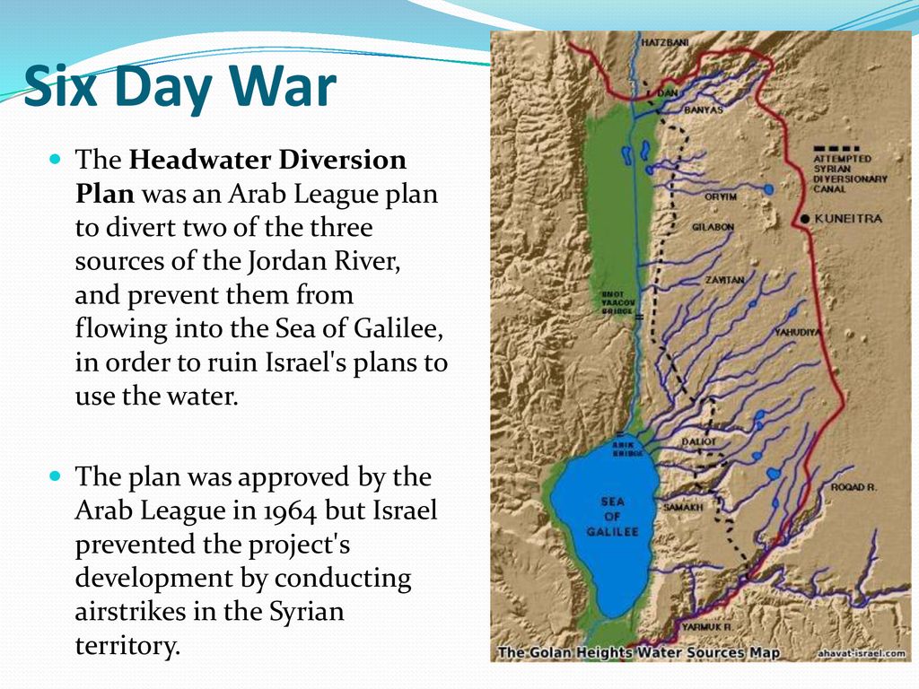
For many analysts, this was a prelude to the Six-Day War in 1967, when Israel occupied the Golan Heights to protect its water supply. The Six-Day War profoundly altered the geopolitical situation in the basin, with Israel now occupying not only the Gaza Strip and Sinai, but also the West Bank and the Golan Heights.
As French researcher Hervé Amiot explains:
« Israel went from being a downstream country to an upstream one, enabling it to gain control of vast resources. Israel now controlled 20% of the northern bank of the Yarmouk and occupied the Golan Heights, controlling all the small rivers flowing into Lake Tiberias. What’s more, total occupation of the West Bank gives them control over the important water tables ».
In fact, as early as 1955, between a quarter and a third of the water came from the groundwater in the south-western part of the West Bank. Today, the West Bank aquifers supply Israel with 475 million m³ of water, i.e. 25-30% of the country’s water consumption (and 50% of its drinking water).
Two months after the seizure of the occupied territories, Israel issued “Military Decree 92”, transferring authority over all water resources in the occupied territories to the Israeli army and conferring « absolute power to control all water-related matters to the Water Resources Officer, appointed by the Israeli courts ». This decree revoked all drilling licenses issued by the Jordanian government and designated the Jordan region a military zone, thus depriving Palestinians of all access to water while granting Israel total control over water resources, including those used to support its settlement projects.
Today, returning the Golan to Syria and recognizing the sovereignty of the Palestinian Authority over the West Bank seems impossible for Israel, given the Hebrew state’s increasing dependence on the water resources of these occupied territories. The exploitation of these resources will therefore continue, despite Article 55 of the Regulations of the IVth Hague Convention, which stipulates that an occupying power does not become the owner of water resources and cannot exploit them for the needs of its civilians…
B. Johnston Plan
OBJECTIVE: In the context of the Cold War, counter Nasser’s growing influence in the region. Offer regional stability by building dams and canals allowing a just sharing of water resources and providing water and energy for both Israel and Arab states welcoming « unfortunate » Palestinian refugees.
One might think that the United States tried very early on to prevent the situation from degenerating in such a predictable way. They tried to take into account Israel’s legitimate interest in securing access to water, the absolute key to its survival and development, while at the same time offering neighboring countries (Jordan, Syria and Lebanon) sufficient resources to accommodate the millions of Palestinians exiled from their homes following the Nakba.
Faced with the risk of conflict, as early as 1953 – years before Israel launched its NWC plan – the American government proposed its mediation to resolve disputes over the Jordan basin. The result was the « Jordan Valley Unified Water Plan » (known as the « Johnston Plan »), named after Eric Allen Johnston, president of the United States Chamber of Commerce and US President Dwight Eisenhower‘s water envoy.
More concretely, “The Unified Development of the Water Resources of the Jordan Valley Region,” was prepared at the request of the United Nations Relief and Works Agency for Palestine Refugees under the direction of the Tennessee Valley Authority.
On Oct. 13, 1953, Eisenhower’s Secretary of State John Foster Dulles, in a top secret letter instructed Johnston what his mission was all about and on Oct. 16, in a public statement Eisenhower explained:
« One of the major causes of disquiet in the Near East is the fact that some hundreds of thousands of Arab refugees are living without adequate means of support in the Arab states. The material wants of these people have been cared for through the United Nations Relief and Works Agency (UNRWA) … It has been evident from the start, however, that every effort must be made by the countries concerned, with the help of the international community, to find a means of giving these unfortunate people an opportunity to regain personal self-sufficiency.
« One of the major purposes of Mr. Johnston’s mission will be to undertake discussions with certain of the Arab states and Israel, looking to the mutual development of the water resources of the Jordan River Valley on a regional basis for the benefit of all the people of the area. …
« Such a regional approach holds a promise of extensive economic improvement in the countries concerned through the development of much needed irrigation and hydroelectric power and through the creation of an economic base on the land for a substantial proportion of the Arab refugees. It is my conviction that acceptance of a comprehensive plan for the development of the Jordan Valley would contribute greatly to stability in the Near East and to general economic progress of the region.«
This plan established the transboundary nature of the Jordan basin and proposed an equitable sharing of the resource, giving 52% of the water to Jordan, 31% to Israel, 10% to Syria and 3% to Lebanon.
The plan, just as the Tennessee Valley Authority during FDR’s New Deal, was essentially based on building dams for irrigation and hydropower. The water was there and correctly managed, sufficient for the needs of the population at that time. Its main features were:
- a dam on the Hasbani River to provide power and irrigate the Galilee area;
- dams on the Dan and Banias Rivers to irrigate Galilee;
- drainage of the Huleh swamps;
- a dam at Maqarin on the Yarmouk River for water storage (capacity of 175 million m³) and power generation;
- a small dam at Addassiyah on the Yarmouk to divert its water toward both the Lake Tiberias and south along the eastern Ghor;
- a small dam at the outlet of Lake Tiberias to increase its storage capacity;
- gravity-flow canals along the east and west sides of the Jordan valley to irrigate the area between the Yarmouk’s confluence with the Jordan and the Dead Sea;
- control works and canals to utilize perennial flows from the wadis that the canals cross.
See details of the Johnston plan in this comprehensive article.
The project was validated by the technical committees of Israel and the Arab League, and did not require Israel to abandon its ambition to green the Negev desert. Unfortunately, however, the presentation of the plan to the Knesset in July 1955 did not result in a vote.
The Arab Committee approved the plan in September 1955 and forwarded it to the Council of the Arab League for final approval. Tragically, this institution also chose not to ratify it on October 11, because of its opposition to an act implying an implicit act of recognition of Israel that would prevent the return of the Palestinian refugees to their home… The mistake here was to isolate the water issue from a broader agreement on peace and justice as the foundation of mutual development.
Then, after the Suez Canal crisis in 1956, the Arab countries, with the exception of Jordan, hardened their stance towards Israel considerably, and henceforth opposed the Johnston plan head-on, arguing that it would amplify the threat posed by that country by enabling it to strengthen its economy. They also claim that increasing Israel’s water resources could only increase Jewish migration to the Hebrew state, thereby reducing the possibility of the return of Palestinian refugees from the 1948 war…
History cannot be rewritten, but the adoption of the Johnston Plan could well have prevented conflicts, such as that of 1967, which cost the lives of 15,000 Egyptians, 6,000 Jordanians, 2,500 Syrians and at least 1,000 Israelis.
C. Jordan’s response: the Ghor irrigation Canal
OBJECTIVE: construct the Jordanian section of the Johnston Plan to have water for irrigation and the capital of Jordan.
At almost the same time as Israel was completing its NWC, Jordan was digging the East Ghor irrigation canal between 1955 and 1964, starting at the confluence of the Yarmouk and Jordan rivers and running parallel to the latter all the way to the Dead Sea on Jordanian territory.
Originally, this was part of a larger project – the « Greater Yarmouk » project – which included two storage dams on the Yarmouk and a future “Western Ghor Canal” on the west bank of the Jordan. The latter was never built, as Israel took the West Bank from Jordan in the 1967 Six-Day War.
In effect, by diverting the waters of the Yarmouk to fill up its own canal, Jordan secured water for its capital Amman and its agriculture, but of course, contributed reducing the waters of the Jordan River.
In Jordan, the Jordan’s river watershed is a region of vital importance to the country. It is home to 83% of the population, the main industries and 80% of irrigated agriculture. It is also home to 80% of the country’s total water resources.
Overall, the Hashemite kingdom is one of the world’s most water-poor countries, with 92% of its territory desert. While Israel has 276 m³ of natural freshwater available per capita per year, Jordan has just 179 m³, more than half of which comes from groundwater.
The UN considers that a country with less than 500 m³ of freshwater per capita per year suffers from « absolute water stress ». Added to this is the fact that since the start of the Syrian civil war, Jordan has welcomed nearly 1.4 million refugees onto its soil, in addition to its 10 million inhabitants.
The East Ghor Canal was designed in 1957 and built between 1959 and 1961 competing with Israel’s NWC. In 1966, the upstream section as far as Wadi Zarqa was completed. The canal was then 70 km long and was extended three times between 1969 and 1987.
The United States, through the U.S. Agency for International Development (USAID), financed the initial phase of the project, after obtaining explicit assurances from the Jordanian government that Jordan would not withdraw more water from the Yarmouk than had been allocated to it under the Johnston Plan. They were also involved in the subsequent phases.
Waterworks in the region are often named after great political figures. The East Ghor Canal was named « King Abdallah Canal (KAC) » by Abdalla II after his great-grandfather, the founder of Jordan. At the time of the peace treaty with Israel in 1994, the two countries shared the flow of the Jordan, and Jordan agreed to sell its water from Lake Tiberias.
D. Mediterranean – Dead Sea Aqueduct
OBJECTIVE: generate hydro-electricity and make Israel independant from Arab oil and gas supplies.
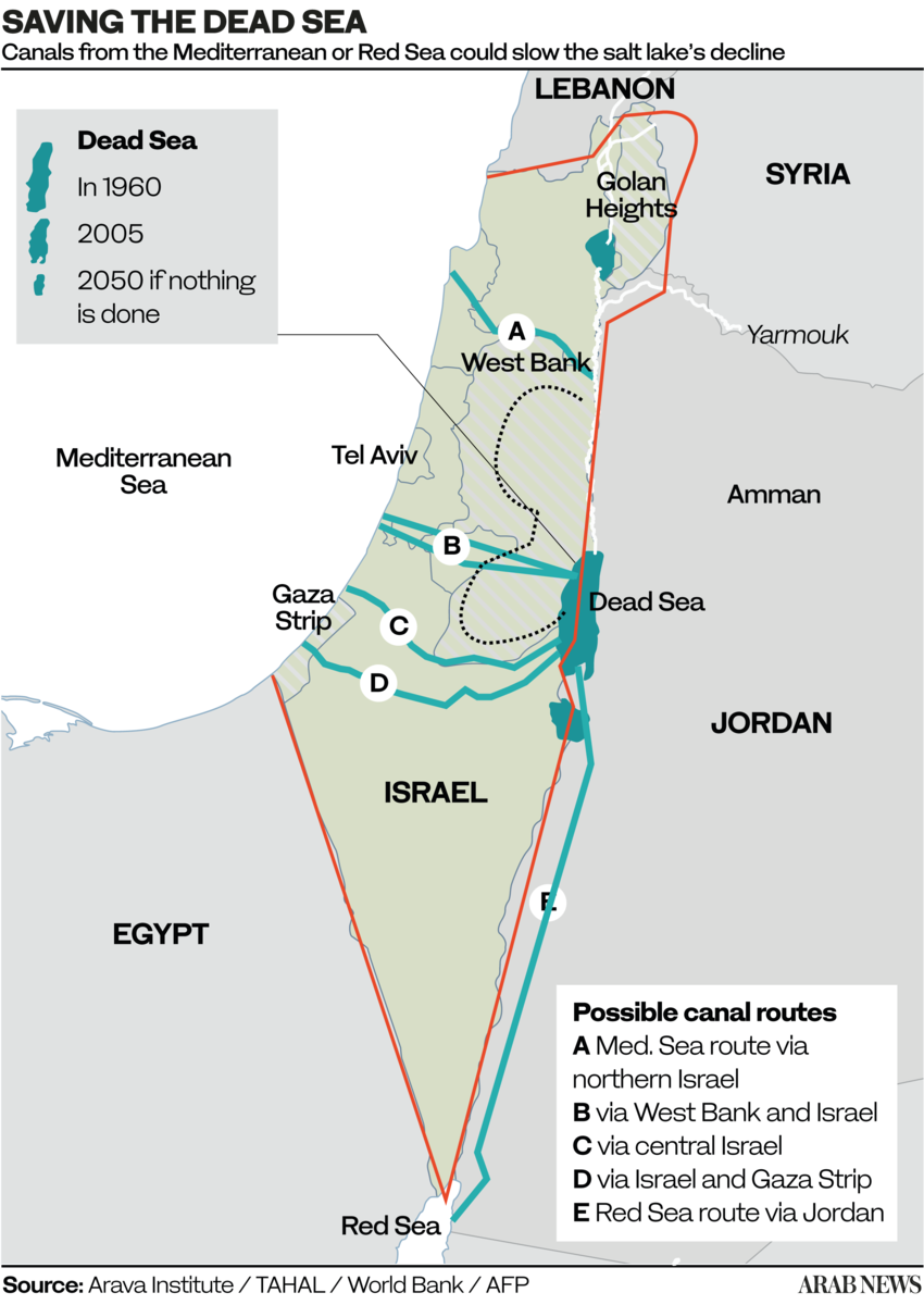
A: Crossing solely Israelian territory;
B and C: Crossing Israel and West Bank (shortest, 70 km);
D. Crossing Gaza and Israel;
E. Crossing only Jordan (longest, 200 km).
The idea of a Dead Sea-Mediterranean Canal was first proposed by William Allen in 1855 in a book entitled The Dead Sea – A new route to India. At the time, it was not known that the level of the Dead Sea was far below that of the Mediterranean, and Allen proposed the canal as an alternative to the Suez navigation Canal.
Later, several engineers and politicians took up the idea, including Theodor Herzl in his 1902 short story Altneuland. Most early projects were based on the left bank of the Jordan, but a modified form, using the right bank (West bank), was proposed after 1967.
After extensive research, German engineers Herbert Wendt and Wieland Kelm proposed not a navigable canal, but an aqueduct consisting essentially of an overhead gallery running West-East, linking the Mediterranean to the Dead Sea.
Their 1975 detailed project study Depressionskraftwerk am Toten Meer – Eine Projektstudie, on how to use the difference of water levels between the Mediterranean sea (level 0) and the Dead Sea (- 400 m) for power generation was the subject of a first publication in the German journal Wasserwirtschaft (1975,3).
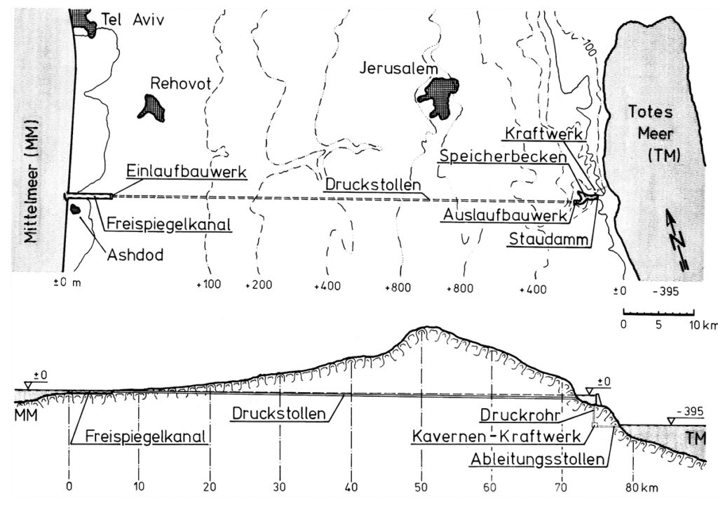
The diagram indicates the system operates as follows:
- The seawater intake is at Ashdod.
- An open channel allows the water to flow by gravity for 7 km.
- From there, the pressurized water travels through a 65 km-long hydraulic gallery;
- The water arrives in a 3km-long reservoir created by a dam on the edge of the steep descent to the Dead Sea. At that point, the water can be used to cool a thermal or nuclear power plant, the heat from which can be used for industrial or agricultural purposes.
- Through a shaft running from the bottom of the reservoir, the water descends a steep 400 metres.
- There, it powers three turbines, each producing 100 MWe.
- Finally, via an evacuation gallery, the seawater reaches the Dead Sea.
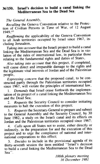
However, since the project was elaborated exclusively by Israel and without any consultation with its Jordanian, Egyptian and Palestinian neighbors, the project ran against a wall of political opposition.
Of course, as with any large scale infrastructure projects, many things needed to be adapted, including tourist equipment, roads, hotels, Jordanian potash exploitation, Palestinian farmland, etc.
Questions were also raised about (very infrequent) potential earthquakes and the difference of salinity of water from the Mediterranean and the Dead Sea.
On Dec. 16, 1981, the UN General Assembly, arguing the canal project « will violate the principle of international law » adopted Resolution 36-150.
That resolution requested the UN Security Council « to consider initiating measures to halt the execution of this project » and calling « upon all States not to assist, either directly or indirectly, in the preparation for and the execution of this project. »
The request, in article 3, to submit a study was fulfilled. The report, not really convincing, details various objections but doesn’t call into question the technical feasability of the project.
E. Red Sea – Dead Sea Water Conveyance

OBJECTIVES: Build a desalination plant close to the Dead Sea to provide fresh water to Jordan, Israel and Palestine by desalinating seawater arriving via a pipeline from the Red Sea. Use the brine to refill the Dead Sea. Use the watersharing as a model for peaceful mutual beneficial cooperation. Make the project the heart of a development corridor.
In the framework of the peace treaty between Israel and the Hashemite Kingdom of Jordan the integrated development Master Plan for the Jordan Rift Valley (JRV) was studied in the mid 1990’s.
The Red Sea – Dead Sea Canal (RSDSC) was considered to be one of the most important potential elements for implementing this Master Plan. The principal development objective of the RSDSC was to provide desalinated drinking water for the people of the area.
On October 17, 1994, then Israeli Prime Minister Yitzhak Rabin and King Hussein of Jordan validated the draft peace treaty between their two countries in Amman, after reaching agreement on the last two points in dispute – the water issue and border demarcation.
On November 26, the Israeli-Jordanian peace treaty was signed with great fanfare in the Arava Valley, between the Red Sea and the Dead Sea, by the prime ministers of the two countries, in the presence of US President Bill Clinton, whose country had helped bring the negotiations between Jerusalem and Amman to a successful conclusion.
This created the condition where the old idea of linking the Red Sea with the Dead Sea, a project renamed and supported by Shimon Peres as the « Peace Canal », could come back on the table.
Former Israeli water commissioner Professor Dan Zaslavsky, who opposed the project on cost grounds, wrote in the Jerusalem Post in 2006 about Peres’ obstinacy. To listen to the scientists, Peres summoned five of them. Each had to present his objections in a few minutes.
« At one point, Peres got up and said, ‘Excuse me. Don’t you remember that I built the nuclear reactor in Dimona? Do you remember that everyone was against it? Well I was right in the end. And this will prove to be the same thing! » And with that, Zaslavsky said with a flourish, « he left! »
The Dead Sea
For millennia, the Dead Sea was filled with fresh water from the Jordan River, via Lake Tiberias. Over the last fifty years, however, it has lost 28% of its depth and a third of its surface area. Its water level is falling inexorably, at an average rate of 1.45 meters per year. Its high salinity – over 27%, compared with the average for oceans and seas of 2-4% – and a level 430 meters below sea level, has always fascinated visitors and provided therapeutic benefits. Stretching 51 kilometers long and 18 kilometers wide, it is shared by Israel, Jordan and the West Bank.
The over-exploitation of upstream water resources (the National Aqueduct in Israel, the Ghor Canal in Jordan), together with potassium mining, is the cause of the sand desert which, if nothing is done, will continue to replace the Dead Sea.
If the Dead Sea needs the Jordan River, the Jordan River needs Lake Tiberias, from which it takes its source. However, the lake too has been affected by drastic drops in its water level in recent years, triggering a vicious circle between the three systems (Lake Tiberias, Jordan River and Dead Sea).
Aqueduct
In response, at the end of 2006, the World Bank and Agence Française de Développement (AFD) assisted Israel and Jordan in the design of a colossal project to link the Dead Sea to the Red Sea via a 180-kilometer mainly underground pipeline.
In the end, the project for an aqueduct starting from the Red Sea and built entirely on Jordanian territory was chosen, with the signing of a tripartite agreement between Israelis, Jordanians and Palestinians in December 2013.
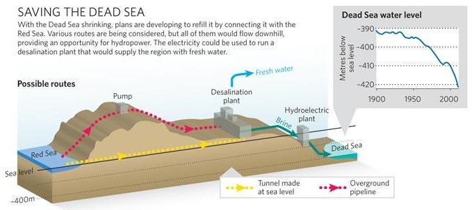
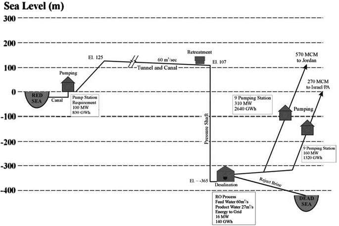
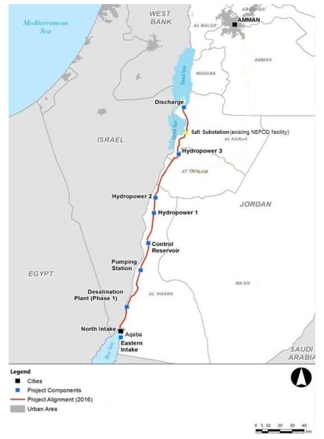
- Sea intake and pumping station
The seawater is pumped to +125 m above sea level at the Red Sea. - Pressure pipeline
The first part of the conveyance system transmits the seawater to the planned elevation. The length is 5 km from Aqaba (3% of the whole alignment). - A tunnel and canal conveyance system
Seawater is transmitted to the regulating and pretreatment reservoirs with a design flow of 60 m3 /s. A 121 km tunnel with 7 m diameter and 39 km canal were designed. - Regulating and pre-treatment reservoirs
Several reservoirs were designed at +107 m at Wadi G’mal at the southeastern margin of the Dead Sea. - Desalination plants
The 2 desalination plants are designed to operate by using the process of hydrostatically supported reverse osmosis to provide desalinated seawater. The main plant will be located at Safi at 365 m below the sea level with a water column of 475 m. - Fresh water
The project will produce around 850 MMC of fresh water per year, to be shared between Jordan, Israel and Palestine, the three countries that manage the Dead Sea. For the transmission of the water to Amman a double pipeline of 200 km with 2.75 m diameter was designed with nine pumping stations for the uplift of 1,500 m. For the transmission to Hebron a double pipeline of 125 km with an elevation difference of 1,415 m was designed. - The brine
The brine reject water will be conveyed from the desalination plant via a 7 km canal to the Dead Sea. 1,100 MMC per year of brine reject water will enter the Dead Sea. - Electricity generation
As the brine runs through the tunnel and canal, the turbines of one or more hydroelectric power plants will generate around 800 megawatts of electricity to partially offset the electricity consumed by pumping; - Three new cities will be built: North Aqaba city in northern Aqaba, South Dead Sea City, close to the desalination plant south of the Dead Sea, and South Amman City (see map at the beginning of this section).
In terms of environmental impact, scientists have expressed concern that mixing the brine (rich in sulfate) from the desalination plants with the Dead Sea water (rich in calcium) could cause the latter to turn white. It would therefore be necessary to proceed with a gradual water transfer to observe the effects of water transfer in this particular ecosystem.
Not enough to stabilize the level of the Dead Sea, but a first step to start slowing down its drying up, emphasized Frédéric Maurel, in charge of this project for AFD, in 2018. « We also need to use water more sparingly, both in agriculture and in the potash industry, » he stressed.
Political will?
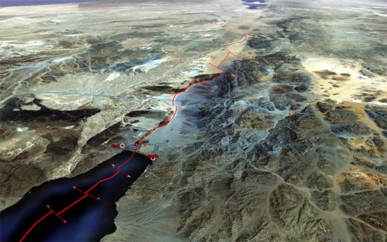
In 2015, as a supplement to the program, agreements had been reached on reciprocal water sales: Jordan would supply drinking water to Israel in the south, which in return would increase its sales of water from Lake Tiberias to supply northern Jordan. And the Palestinians would also receive additional water supplies from Israel. By the end of 2016, five consortia of companies had been shortlisted.
In 2017, the European Investment Bank produced a 264 page detailed study to support the plan.
On the Israeli side, saving the Dead Sea is a necessity to maintain seaside tourism and thermalism. It is also a lever to guarantee its hydraulic control over the West Bank, as Israel does not trust the Palestinian Authority to manage water. Honest elements of the Hebrew state are aware of the peacemaking potential of this project, and need a stable partner in the region. Jordan, for its part, was by far the most interested in this project, given its critical situation.
In 2021, Jordan decided to put an end to the joint water pipeline project, believing that there was « no real desire on the part of the Israelis » for the plan, which had stagnated for several years, to go ahead.
To face its growing needs, Jordan has decided to build its own desalination plant directly on the Red Sea. The Aqaba-Amman Water Desalination and Conveyance Project will take water from the Red Sea at the Gulf of Aqaba in the south, desalinate it, and channel it 450 kilometres north to the capital Amman and its surrounding area, supplying a desperately needed 300 million cubic metres of water a year. Studies are complete and construction will start on July 2024. The plant will be powered with solar energy.
In 2022, Jordan, the UAE and Israel signed a memorandum of understanding (MoU) to continue feasibility studies for two interconnected projects: establishing the water desalination station at the Red Sea (Prosperity Blue) and establishing a solar power plant in Jordan (Prosperity Green). However, due to the ongoing war against Gaza and the rejection of the Jordanian public regarding the agreement’s signing, the Jordan government announced the suspension of the agreement.
The Dead Sea might slowly reappear
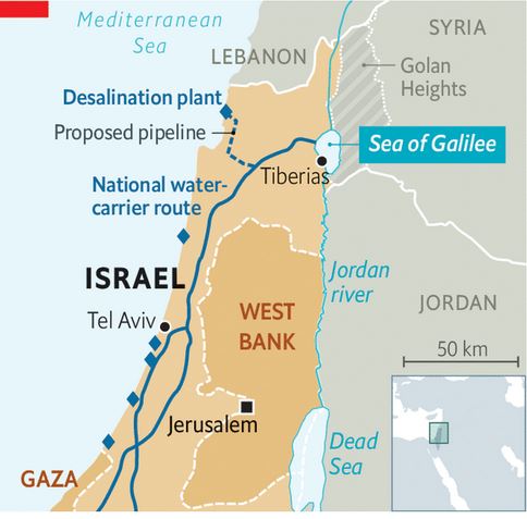
With huge desalinization capacities in hand, Israel adopted in 2023 the National Carrier Flow Reversal Project to return water to its natural resources, in particular to Lake Tiberias, the very source of freshwater for its entire national water system.
Lake Tiberias, as we have seen, is therefore a national treasure, a centerpiece of tourism, agriculture and, as we have seen, geopolitics.
According to Dodi Belser, Director of Innovation at water state giant Mekorot, if Israel wants to increase the water it sends to its Jordanian neighbors and to protect its reservoir, it’s vital to retain the lake’s water level. Currently Israel taps 100 million cubic meters of water from Lake Tiberias to send to Jordan, and did so even during the drought years of 2013 to 2018.
Increase resilience to climate chaos and preparing eventual futur water sharing, gave birth to the idea to pump desalinated water into the Lake Tiberias, up to 120 million cubic meters a year until 2026. That is happening right now.
It can partly increase the level of the Jordan river and therefore the water arriving into the Dead Sea. But the salt in the Dead Sea comes from the waters of the Jordan River. Every year, the famous river brings it some 850,000 tonnes of salt.
F. Turkish water sales
Turkye, a veritable « water tower » in the region, has long dreamed of exporting its water to Israel, Palestine, Cyprus and other Middle Eastern countries at a premium.
The most ambitious of these projects was President Turgut Ozal‘s « Peace Water Pipeline » in 1986, a $21 billion project to pipe water from the Seyhan and Ceyhan rivers to cities in Syria, Jordan and the Arab states of the Gulf.
In 2000, Israel was strongly considering purchasing 50 million m3 per year for 20 years from the Manavgat river near Antalya, but since November 2006, the deal has been put on hold.
The Manavgat project, technically completed in mid-March 2000, was a pilot project.
The complex on the Manavgat river – which rises in the Taurus mountains and flows into the Mediterranean between Antalya and Alanya – includes a pumping station, a refining center and a ten-kilometer-long canal. The aim was then to transport this fresh water by 250,000-ton tankers to the Israeli port of Ashkelon for injection into the Israeli NWC.
Eventually, Jordan was also interested in Turkey’s aquatic manna. A second customer downstream of its network would enable Israel to share costs. Another possibility would be to transport the water via a water pipeline linking Turkey to Syria and Jordan, and ultimately to Israel and Palestine if the latter could reach an agreement with its partners. The Palestinians, for their part, have been looking for a donor country to subsidize freshwater imports by tanker to Gaza.
The Manavgat project is not the only one through which Ankara hopes to sell its water. In 1992, Suleyman Demirel, then Prime Minister, expressed a credo that went viral: « Turkey can use the waters of the Tigris and Euphrates rivers as it sees fit: Turkey’s water resources belong to Turkey, just as oil belongs to Arab countries.”
The countries downstream of the two rivers – Iraq and above all Syria – immediately protested. For them, the multiple dams that Ankara plans to build on the region’s main freshwater sources for irrigation or power generation are simply a way for the heir to the Ottoman Empire to assert its authority over the region.
Whatever Ankara’s real ambitions, the country has a real treasure trove at its disposal, especially given the dwindling resources of neighboring countries.
In the end, since November 2006, Israeli supporters of desalination have objected to the price of Turkish water and questioned the wisdom of relying on Ankara, whose government is critical of Israeli policies. Desalination or importation? The choice is a Cornelian one for Israel. And an eminently political one, since it comes down to knowing whether to stick to positions based on self-sufficiency or whether to play the regional cooperation card, which amounts to betting on trust…
G. Hidden defects and non-implementation of Oslo
The recognition of Israel by Yasser Arafat – leader of the Palestinian Liberation Organisation –, and the election of Yitzhak Rabin as Israel’s Prime minister in 1992 opened new opportunities for peace and cooperation. The Oslo accords they signed established the Palestinian Authority and determined temporary groundwater allocations from the West Bank to Israel and Palestine. In the declaration, both parties agreed on the principle of “equitable utilisation” between Palestinians and Israelis.
The collapse of mutual trust following the assassination of Rabin in November 1995 and the subsequent election of Benjamin Netanyahu, who had been highly critical of Oslo, negatively affected cooperation on water.
In 2000, during the first six months of the second Intifada, there was hardly any contact between both sides regarding water issues. But with reason coming back, despite the conflict, Israeli and Palestinian leaders committed themselves to separating the water issue from violence and reactivated cooperation over water.
In 2004, Israel reportedly proposed a plan to build a desalination plant in order to increase the quantity of freshwater available and to channel desalinated water to the West Bank. Fearing that this might in effect imply a renunciation to Palestinian water claims on the Mountain aquifer (75% of which is allocated to Israel even though the Aquifer is on Palestinian land), the Palestinians rejected this solution.
The Oslo Accords, signed by Israel and the Palestine Liberation Organization (PLO) in 1993, although stipulating that « Israel recognizes the water rights of Palestine », in reality allowed Israel to continue controlling the region’s water sources… while awaiting a resolution to the conflict. Oslo II provided for the postponement of negotiations on water rights until those on permanent status, as well as on the status of Jerusalem, refugees’ right of return, illegal settlements, security arrangements and other issues.
But final status talks, scheduled to take place five years after the implementation of the Oslo Accords (in 1999, as planned), have not yet taken place.
The Oslo Accords also provided for the creation of a water management authority, and their « Declaration of Principles » stressed the need to ensure « the equitable use of common water resources, for application during the interim period [of the Oslo Accords] and thereafter ».
Hence, for decades, Israel has perpetuated a principle of water distribution that existed before the Oslo Accords were signed, allowing Israelis to consume water at will while limiting Palestinians to a predetermined 15% share.
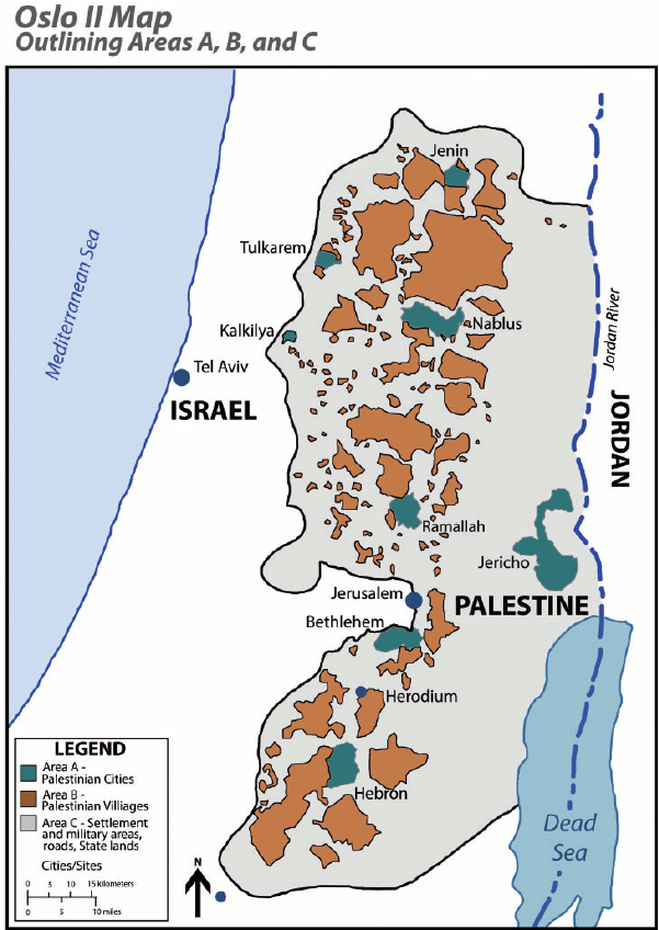
The Oslo agreements did not take into account the division of the West Bank into zones A, B and C when it came to organizing water distribution between Israel and the Palestinians.
Israel was finally granted the right to control water sources, even in PA-controlled areas A and B.
Most water sources were already located in Area C, which is entirely controlled by Israel and comprises almost 61% of the West Bank.
On the ground, Israel has connected all the settlements built in the West Bank, with the exception of the Jordan Valley, to the Israeli water network. The water supply to Israeli communities on both sides of the Green Line is managed as a single system, under the responsibility of Israel’s national water company, Mekorot.
While the Oslo Accords allowed Israel to pump water from areas under its control to supply settlements in the occupied West Bank, they also prevent the PA from transferring water from one area to another in those it administers in the West Bank. Israel has disavowed most of the provisions of the Oslo Accords, but remains committed to those relating to water.
A member of the Palestinian delegation that signed the Oslo Accords, wishing to remain anonymous, tells Middle East Eye magazine that the delegation’s lack of expertise at the time resulted in the signing of an agreement that
« placed the fate of Palestinian access to water in Israel’s hands (…) Most Palestinian water experts withdrew from the negotiations at the outset of the Oslo process, as they were not satisfied with the way the negotiations were being conducted », he stressed. « As for the political leaders, their main objective was to reach an agreement. »
In practice, this means that Palestinians in the occupied West Bank are at the mercy of the Israeli occupation when it comes to their water supply.
Inequalities in terms of access to water in the West Bank are glaring, as shown by the Israeli NGO B’Tselem in a report entitled Parched, published in May 2023.
In 2020, each Palestinian in the West Bank consumed an average of 82.4 liters of water per day, compared with 247 liters per person in Israel and the settlements.
This figure drops to 26 liters per day for Palestinian communities in the West Bank that are not connected to the water distribution network. 36% of West Bank Palestinians have year-round access to running water, compared with 100% of Israelis, including settlers.
The Palestinian Authority, which claims more water, points out that Palestinian agriculture plays a major role in the economy of the Occupied Territories (15% of GDP, 14% of the working population in 2000). In comparison, Israeli agriculture, while far more productive, employs 2.5% of the working population and produces 3% of GDP.
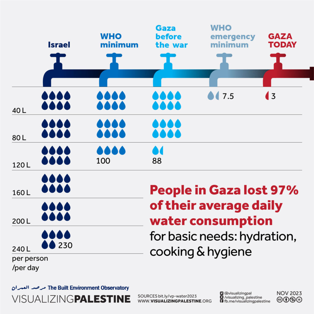
Added to this the fact that the arable land recognized by Israel under the Oslo Accords as totally or partially autonomous to the Palestinians is located in the limestone uplands, where access to water is difficult, since it is necessary to dig deep to reach the water table.
What’s more, in Israel and the settlements, 47% of land is irrigated, compared with only 6% of Palestinian land. The Palestinian Authority is currently demanding rights to 80% of the mountain aquifer, which Israel cannot conceive of.
Myth of Thirsty Palestinian
Israeli spokespeople, such as Akiva Bigman in his article titled « The Myth of the Thirsty Palestinian » have three answers ready to pull out when they are confronted with the water shortages in West Bank Palestinian towns:
1) “Because the PA does not properly maintain its water system, it suffers from a 33 percent rate of water loss, mostly due to leakage; in contrast to an 11 percent loss from the Israeli system.”
Answer: leakage varies from 20 to 50% in the USA, far above the rate of poor Palestine.
2) “40 potential drilling sites in the Hebron area were identified and approved by the Israeli-Palestinian Joint Water Committee; but in the two decades since then, drilling has taken place in only three places, and this is in spite of substantial funding provided to the PA by donor nations.”
One can ask where the money went. And yes, in reality, at the end of the day, for various technical reasons and unexpected drilling failures in the eastern basin of the aquifer (the only place the agreement allows the Palestinians to drill), the Palestinians ended up producing less water than the agreements set.
3) Israel has in its great generosity “doubled the amount of water it supplies to the Palestinians, compared to what was called for in the Oslo Accords.”
True. However, Oslo didn’t set a limit to the amount of water Israel can take, but limited the Palestinians to 118 MCM from the wells that existed prior to the accords, and another 70-80 MCM from new drilling. According to the Israeli NGO B’Tselem, as of 2014 the Palestinians are only getting 14 percent of the aquifer’s water. That is why the Israeli state company Mekorot (obeying to government directives) is selling the Palestinians the double of water stipulated in the Oslo Agreement – 64 MCM, as opposed to 31 MCM. 64 + 31 = 95 MCM in total, to be compated with current consumption by Palestinians in the West Bank: 239 MCM of water in 2020 of which 77.1 of them purchased from Israel.
A final detail that speaks volumes: Palestinians are charged the price of drinking water for their agricultural water while Jewish settlers benefit from agricultural tariffs and subsidies. The justification being that the Jewish settlers have invested in expensive irrigation techniques such as desalination
H. Ben Gurion Navigation Canal
At the end of 2023, the idea of the Ben-Gurion navigation Canal project was revived in the media. The canal would link the Gulf of Aqaba (Eilat) in the Red Sea to the Mediterranean Sea, passing through Israel to terminate in or near the Gaza Strip (Ashkelon). This is an Israeli alternative to the Suez Canal, which became topical in the 1960s following Nasser’s nationalization of Suez.
The first ideas for a connection between the Red Sea and the Mediterranean appeared in the mid-19th century, on the initiative of the British, who wanted to link the three seas: the Red, the Dead and the Mediterranean. As the Dead Sea lies 430.5 meters below sea level, such an idea was not feasible, but it could be realized in another direction. Frightened by Nasser’s nationalization of Suez, the Americans considered the option of the Israeli canal, their loyal ally in the Middle East.
In July 1963, H. D. Maccabee of Lawrence Livermore National Laboratory, under contract to the U.S. Department of Energy, wrote a memorandum exploring the possibility of using 520 underground nuclear explosions to help dig some 250 kilometers of canals across the Negev desert. The document was classified until 1993. « Such a canal would constitute a strategically valuable alternative to the present Suez Canal and would probably contribute greatly to the economic development of the surrounding region, » says the declassified document.
The idea of the Ben Gurion Canal resurfaced at the same time as the signing of the so-called « Abraham Agreements » between Israel and the United Arab Emirates, Bahrain, Morocco and Sudan.
On October 20, 2020, the unthinkable happened: Israel’s state-owned Europe Asia Pipeline Company (EAPC) and the UAE’s MED-RED Land Bridge signed an agreement to use the Eilat-Ashkelon pipeline to transport oil from the Red Sea to the Mediterranean, avoiding de facto the Suez Canal.
On April 2, 2021, Israel announced that work on the Ben Gurion Canal was due to start in June of the same year. But this has not been the case. Some analysts interpret the current Israeli reoccupation of the Gaza Strip as an event that many Israeli politicians were waiting for to revive an old project.
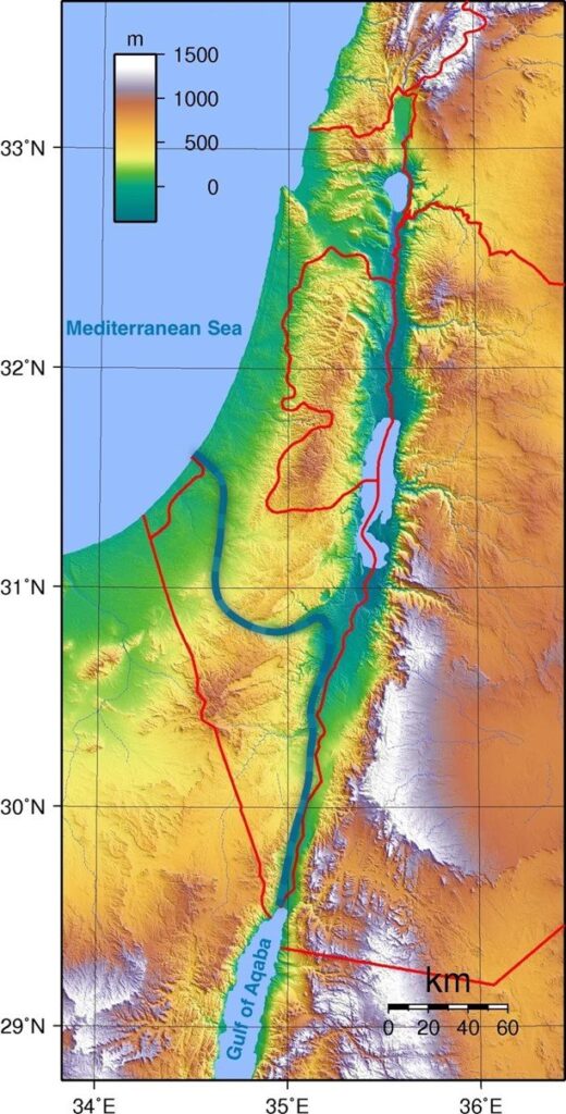
A closer look at the planned route shows that the canal starts at the southern edge of the Gulf of Aqaba, from the port city of Eilat, close to the Israeli-Palestinian border, and continues through the Arabah valley for around 100 km, between the Negev mountains and the Jordanian highlands. It then turns west before the Dead Sea, continues through a valley in the Negev mountain range, then turns north again to bypass the Gaza Strip and reach the Mediterranean Sea in the Ashkelon region.
The project’s promoters argue that their canal would be more efficient than the Suez Canal because, in addition to being able to accommodate a greater number of ships, it would allow the simultaneous two-way navigation of large vessels thanks to the design of two canal arms.
Unlike the Suez Canal, which runs along sandy banks, the Israeli canal would have hard walls that require almost no maintenance. Israel plans to build small towns, hotels, restaurants and cafés along the canal.
Each proposed branch of the canal would be 50 meters deep and around 200 meters wide. It would be 10 meters deeper than the Suez Canal. Ships 300 meters long and 110 meters wide could pass through the canal, corresponding to the size of the world’s largest ships.
If completed, the Ben-Gurion Canal would be almost a third longer than the Suez Canal, which measures 193.3 km, or 292.9 km. Construction of the canal would take 5 years and involve 300,000 engineers and technicians from all over the world. Construction costs are estimated at between $16 and $55 billion. Israel stands to gain $6 billion a year.
Whoever controls the canal, and apparently it can only be Israel and its allies (mainly the USA and Great Britain), will have enormous influence over international supply chains for oil, gas and grain, as well as world trade in general.
Israel argues that such a project would undermine the power of Egypt, a country strongly allied with Russia, China and the BRICS and therefore « a threat » to the West! With the depopulation of Gaza and the prospect of total Israeli control over this tiny territory, some Israeli politicians, including Netanyahu, are once again salivating over the prospect of such a project.
As Croatian analyst Matia Seric pointed out in Asia Review in November 2023:
« If realized, the Ben Gurion Canal would bring about a tectonic change as it would overshadow the Suez Canal. The project would launch Israel into the center of world shipping and world trade. Egypt would lose its monopoly on the shortest route between Africa, Asia and Europe. The emergence of an alternative Israeli channel would have a devastating impact on the Egyptian economy. President el-Sisi may regret putting his trust in Israel and Western governments above the well-being of the two million Palestinians in Gaza. Egypt, apart from formally condemning the mass crimes committed by Israeli forces against the civilian Palestinian population, has done little to prevent Israeli wrongdoing, which some call genocide. Israeli Prime Minister Benjamin Netanyahu has repeatedly expressed support for the idea of the canal along with the idea of building a high-speed railway from Eilat to Beersheba. Realizing, or at least starting, this project could redeem Netanyahu from his many mistakes during his long reign, including the intelligence and military failures that facilitated the October 7 attack by Hamas. »
I. Oasis Plan
It is in the light of all these failures that the fundamental contribution of the « Oasis Plan » proposed by the American economist Lyndon LaRouche (1922-2019) becomes apparent.
In 1975, following talks with the leaders of the Iraqi Baath Party and sane elements of the Israeli Labor Party, the American economist LaRouche saw his Oasis Plan as the basis for mutual development to the benefit of the entire region.
Instead of waiting for « stability » and « lasting peace » to arrive magically, LaRouche proposed and even launched projects in the interests of all, and « recruited » all partners to participate fully, first and foremost in their own interests, but in reality in the interests of all.

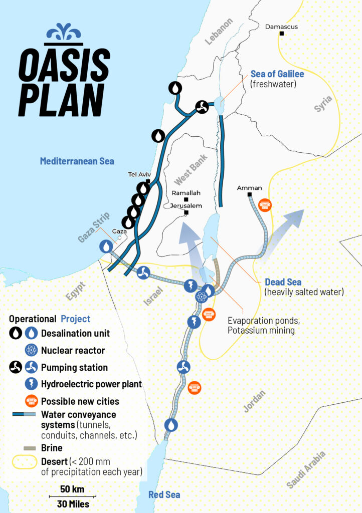
LaRouche’s « Blue Peace » Oasis plan, to be put on the table of diplomatic negotiations as the « spine » of a durable peace agreement », includes:
- Israel’s relinquishment of exclusive control over water resources in favor of a fair resource-sharing agreement between all the countries in the region;
- The reconstruction and economic development of the Gaza Strip, including the Yasser Arafat International Airport (inaugurated in 1998 and bulldozered by Israeli in 2002), a major seaport backed up by a hinterland equipped with industrial and agricultural infrastructure.
- A floating, underwater or off-shore desalination plant will be stationed in front of Gaza.
- The construction of a fast rail network reconnecting Palestine (including Gaza) and Israel to its neighbors;
- The construction, for less than 20 billion US dollars of both the Red-Dead and the Med-Dead water conveyance system composed of tunnels, pipelines, water galeries, pumping stations, hydro-power units and nuclear powered desalination plants.
- Salted sea water, arriving at the Dead Sea, before desalination, will « fall » through a 400 meter deep shaft and generate hydro-electricity.
- Following desalination, the fresh water will go to Jordan, Palestine and Israel; the brine will refill and save the Dead Sea.
- The nuclear powered desalination plant will produce heat and electricity with « hybrid desalination » combining evaporation and Reverse Osmosis (RO) ;
- The industrial heat of the Molten Salt (MSR) high temperature reactors (HTR), will also be tapped for industrial and agricultural purposes;
- The reservoirs of the water conveyance systems will also function as a Pumped Storage Power Plant (PSPP), essential for regulating the region’s power grids;
- Part of the seawater going through the Med-Dead Water conveyance system will be desalinated in Beersheba, the « capital of the Negev » whose population, with new fresh water supplies, can be doubled.
- New cities and « development corridors » will grow around the new water conveyance systems.
- Israel’s Dimona nuclear center and power plant (currently a military reactor and medical nuclear waste treatment center) can form the basis to create a civilian nuclear program and contribute to the construction of nuclear desalination plants. Jordan can supply the uranium.
- US and Israeli plans to prepare the housing of 500,000/1 million people in the Negev exist but should be entirely reconfigured in terms of both scope and intent. They cannot be a mere extension of exclusively Jewish settlements, but should offer the opportunity to all Israeli citizens, in peaceful cooperation with the Bedouins who live there, the Palestinians and others, to roll back a common enemy: the desert.
- The policy of illegal settlements in the West Bank shall be halted. Settlers will be encouraged (through taxation, etc.) to relocate to the Negev, where they, in a shared effort with the Bedouins, Palestinians and others, can take up productive jobs and make the desert bloom (62% of Israeli territory).
PS: The Oasis Plan plan aims to bring peace to all through mutual development. It has nothing to do with Netanyahu’s Ben-Gurion canal project, a megalomaniac plan for a navigation canal connecting the Red Sea with the Mediterranean aimed to compete with the Suez Canal.
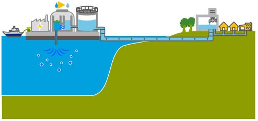
Alvin Weinberg, Yitzhak Rabin and Lyndon LaRouche
LaRouche proposed coupling hydrological, energy, agricultural and industrial infrastructures. These agro-industrial complexes, built around small high-temperature nuclear reactors, were called « nuplexes », a concept put forward in the post-war period by the American scientist Alvin Weinberg, head of the Oak Ridge Laboratories in Tennessee (ORNL) and co-inventor of several types of nuclear reactor, notably the molten-salt line using thorium as fuel (and therefore without the production of weapons-grade plutonium).
In chapter 8 of his autobiography, Weinberg recounts how ORNL, « embarked on a great enterprise: desalinating the sea with cheap nuclear power », with « multi-purpose » plants, « producing water, electricity and process heat at the same time ». The assertion that this was possible, Weinberg reports, « caused a stir within the Atomic Energy Commission ».
In the end, it was President John F. Kennedy who reacted most enthusiastically, speaking on September 25, 1963:
“We are now examining in the United States today the mixed economic-technical question of whether the very large scale nuclear reactors can produce unexpected savings in the simultaneous desalination of water and the generation of electricity? We will have before this decade is out or sooner a tremendous nuclear reactor which makes electricity and at the same time gets fresh water from salt water at a competitive price. What a difference this can make to the United States. And indeed, not only the US but all around the globe where there are so many deserts on the ocean’s edge.”
The idea reached later the ear of AEC’s patron Lewis Strauss.
“The time was 1967, just after the Six-Day War, and the Middle East was much on our minds. The ultimate problem of the Middle East is water – a point that is now perhaps more fully recognized than it was in 1967. Why not build dual-purpose nuclear and electric desalting plants in Egypt, Israel and Jordan – literally make the deserts bloom– and thereby create a major new possibility for a settlement in the Israeli-Arab conflict?”
Lewis conveyed this idea to Eisenhower and Ike published in Life magazine an outline of what became known as the Eisenhower plan, based “on what Lewis and I had discussed”, writes Weinberg.
ORNL then sent a team to visit Egypt, Israel and Lebanon where they were warmly received. The visit brought to Tennessee Israeli and Egyptian engineers who were integrated in the Middle East Study Project,
“which studied what we called ‘nuclear-powered agro-industrial complexes,’ something already studied in 1966. Such complexes would use nuclear reactors to produce electricity and water; the electricity would be used for both domestic and industrial purposes; the water would be used to grow high-value crops.”
“The Middle East project adapted these earlier results to the Israeli-Egyptian situation. A multi-volume report of the Middle East project was issued in which we examined the feasibility of nuclear agro-industrial complexes to be built as national projects in the El-Hamman area near Alexandria in Egypt, and the western Negev area of Israel, and as an international project near the Gaza strip. The implication was that the complexes would be subsidized by the United States.”
“I met with then-ambassador Yitzhak Rabin of Israel for about an hour at the Knoxville airport to tell him about our results. Rabin, who became prime minister of Israel, was skeptical – both as to the political feasibility of a project conducted jointly by Israelis and Arabs, and the economic feasibility of such a huge undertaking. But most of all he suggested that we had extraordinary chutzpah, sitting in Tennessee and figuring out a scheme to resolve a bitter ethnic dispute some six thousand miles away! Of course Rabin had a point on both scores; but I couldn’t refrain from saying, ‘But Mr. Ambassador, is our drawing up plans in Tennessee for agro-industrial complexes for the Middle East is any sillier than Theodore Herzl’s drawing up plans for Israel, in a Vienna café in 1896?’”
Weinberg, clearly unaware of the Dulles brothers‘ operations sabotaging anything good Ike wanted to accomplish regretted: “The Eisenhower-Baker plan was never implemented: the political will needed to support building large reactors in the strife-riven Middle East was lacking…”
The LaRouche Oasis plan, like any other proposal along the same lines, has so far been blocked by the Israeli, American and British sides, and we know only too well what happened to Yitzhak Rabin, assassinated after signing the Oslo Accords, to Shimon Peres, ousted, and to a demonized Yasser Arafat. In addition, LaRouche has been slandered and called an anti-Semite.
On April 13, 2034, LaRouche’s Oasis Plan and its relevance for today was discussed and debated during an international zoom conference and endorsed by several high level ambassadors and diplomats from Palestine, South Africa, Russia and Guyana.
Similar events are being prepared to continue the discussion and turn this dream into reality.