Étiquette : canal
Israel-Palestine: Time to Make Water a Weapon for Peace

« If we solve all the problems in the Middle East,
but not the problem of sharing water, our region will explode.
Peace will not be possible »
(Yitzhak Rabin, former Israeli Prime Minister, 1992).
« You only make peace with your enemies. »
(Yitzhak Rabin.)
Contents:
Introduction
1. Geography of the Middle East
2. Rainfall and Water resources
3. Hydrography of the Jordan basin
A. Source
B. Tributaries
C. Lake of Tiberias
D. Yarmouk river
4. Water sources for Israel-Palestine
A. Surface water
B. Groundwater
C. Desalination
D. Reuse of Waste water
5. Water Infrastructure Projects
A. National Water Carrier (NWC)
B. Johnston Plan
C. Ghor Canal
D. Med – Dead Sea aqueduct
E. Red Sea – Dead Sea Water Conveyance
F. Turkish projects
G. Hidden defects and non-application of the Oslo agreements
H. Ben-Gurion Canal
I. Oasis Plan
J. Alvin Weinberg, Yitzhak Rabin and Lyndon LaRouche
Introduction
This article provides readers with the keys. To understand the history of the water wars that continue to ravage the Middle East, it is essential to understand the geological, hydrographical, geographical and political issues at stake. In the second part, we examine the various options for developing water resources as part of a strategy to overcome the crisis. We will deal with the gas issue, another subject of potential conflict or cooperation, in a later article.
1. Geography
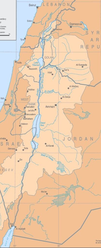
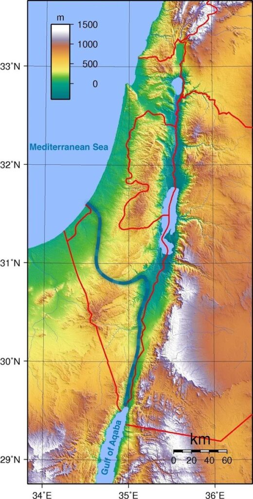
The Jordan River basin is shared by four countries: Lebanon, Syria, Jordan and Israel, plus the Palestinian territories of the West Bank and Gaza.
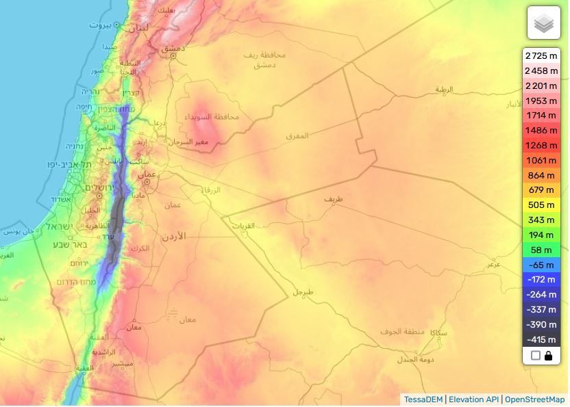
Situated in the hollow of a tectonic depression on the great fault that runs from Aqaba to Turkey, the Jordan Valley is one of the lowest-lying basins in the world, flowing into the Dead Sea at an altitude of 421 meters below sea level.
See interactive topographic map.
Added to this is the fact that this is an endorheic basin, i.e. a river that flows neither into the sea nor the ocean. As in the Aral Sea basin in Central Asia, this means that any water drawn or diverted upstream reduces the level of its ultimate receptacle, the Dead Sea (see below), and can even potentially make it disappear.
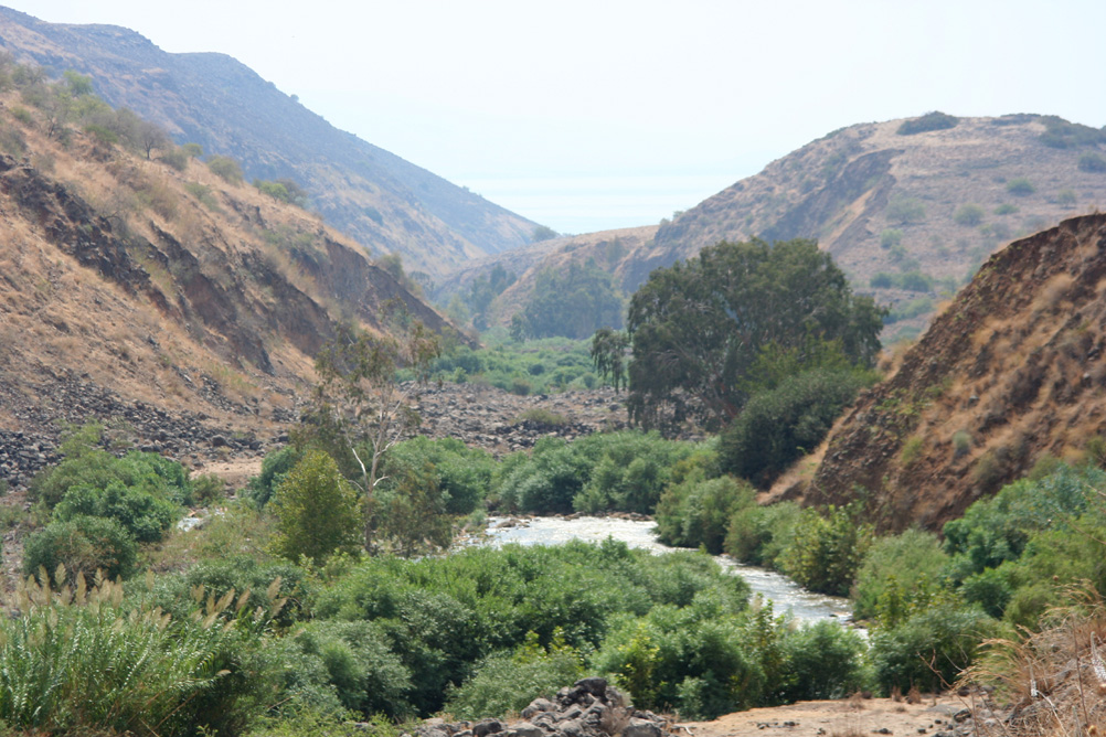
While remaining a fundamental artery for the entire region, the Jordan River has a number of drawbacks: its course is not navigable, its flow remains low and its waters, which are highly saline, are polluted.
As one of the key factors in the « Water, Energy, Food nexus » – three factors whose interdependence is such that we can’t deal with one without dealing with the other two – water resource management remains a key issue, and holds a primordial place for any future shared between Israel and its Arab neighbors. To grow food, one needs water. But to desalinate sea water, Israel spends 10 % of its electricity generated by consuming gas and oil.
2. Rainfall and water resources
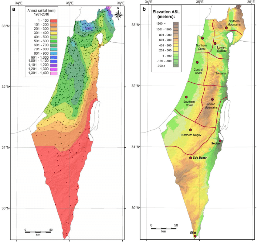
The Middle East forms a long, arid strip, only accidentally interrupted by areas of abundant rainfall (around 500-700 mm/year), such as the mountains of Lebanon, Palestine and Yemen.
Geographically, much of the Middle East lies south of the isohyet (imaginary line connecting points of equal rainfall) indicating 300 mm/year.
However, precipitation has only a limited effect due to its seasonality (October-February).
As a result, river flow and flooding are irregular throughout the year, as well as between years. The same applies to groundwater recharge.
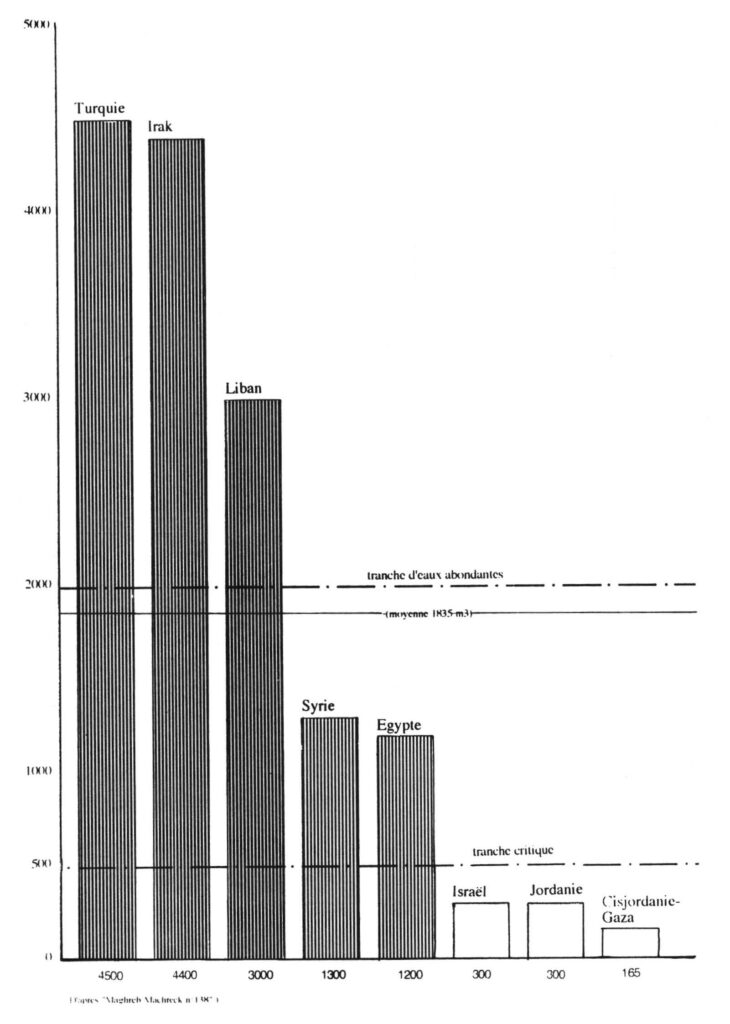
On a state-by-state basis, total water resources are very unevenly distributed in the region:
—Turkey and Iraq have over 4,000 cubic meters per person per year, and Lebanon around 3000 m³/person/year, which is above the regional average (1,800 m³/person/year).
—Syria and Egypt have around 1200 m³/person/year, one third lower.
On the other hand, some countries are below the critical 500 m³/year/capita bracket:
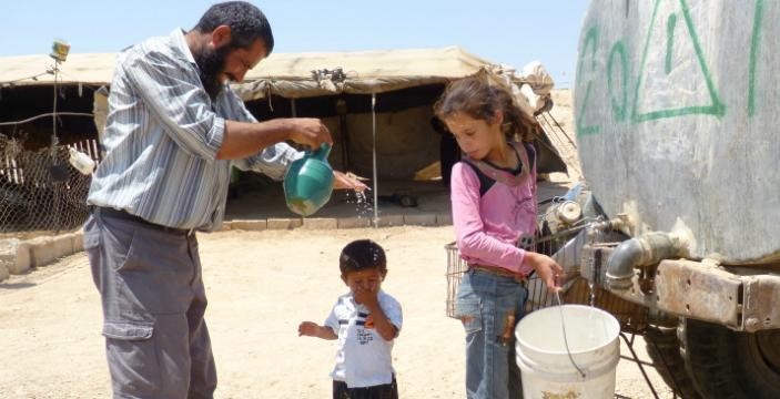
—Israel and Jordan have 300 m³/year/capita, and the Palestinian Territories (West Bank-Gaza) less than 200 m³/year/capita. They are in what the World Health Organization (WHO) calls a situation of « water stress ».
The Middle East enjoys plenty of water on a regional scale, but has many areas in chronic shortage, on a local scale.
3. Hydrography of the Jordan basin
A. Source
360 km long, the Jordan River rises from water flowing down the slopes of Jabal el-Sheikh (Mount Hermon) in southern Lebanon on the border with Syria.
B. Tributaries
Once over the Israeli border, three tributaries join the Jordan about 6 kilometers upstream from the former Lake Hula (now reclaimed):
1. The Hasbani, with a flow of 140 million cubic meters (MCM) per year, rises in Lebanon, a country it crosses over 21 kilometers. The upper reaches of the Hasbani vary greatly with the seasons, while the lower reaches are more regular.
2. The Banias, currently under Israeli control and 30 kilometers long, has an annual flow close to that of the Hasbani (140 MCM). It rises in Syria in the Golan Heights, and flows into Israel for around 12 kilometers before emptying into the Upper Jordan.
3. The Nahr Leddan (or Dan) forms in Israel when the waters of the Golan Heights come together. Although restricted, its course remains stable and its annual flow is greater than that of the other two tributaries of the Upper Jordan, exceeding 250 MCM per year.
C. Lake Tiberias or Kinneret (aka Sea of Galilee)
The Jordan then flows through 17 km of narrow gorges to reach Lake Tiberias, where the salinity is high, especially as the freshwater streams flowing into it have been diverted. Lake Tiberias, however, receives water from the many small streams running through the Golan Heights.
D. Yarmouk River
Next, the Jordan meets the Yarmouk River (bringing in water from Syria), then meanders for 320 km (109 km as the crow flies) to reach the Dead Sea. These 320 km are occupied by a humid plain (the humid zor), with subtropical vegetation, dominated on both sides (West Bank and Jordanian) by dry, gullied terraces.
4. Water sources for Israel
The Hebrew state has four main sources of water supply:
A. Surface Water
Israel benefits first and foremost from the freshwater reserves of Lake Tiberias in Galilee, in the north of the country. Crossed by the Jordan River, this small inland sea accounts for 25% of Israel’s water needs. The annexation of the Golan Heights and the occupation of southern Lebanon have made this source of water a sanctuary.
B. Groundwater
In addition to surface water (lakes and rivers), the country can rely on its coastal aquifers, from Haifa to Ashkelon.
Located between Israel and the occupied West Bank, the main aquifer, the Yarkon-Taninim mountain aquifer, has a capacity of 350 MCM per year. In the northeast and east of the West Bank are two other aquifers with capacities of 140 and 120 MCM per year respectively.
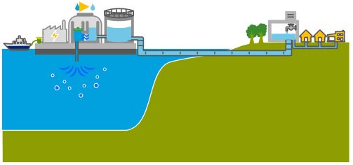
C. Seawater desalination

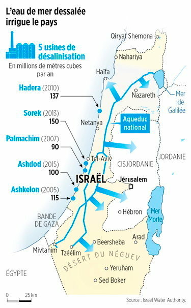
Five desalination plants built along the country’s coastline — in Ashkelon (2005), Palmachin (2007), Hadera (2010), Sorek (2013) and Ashdod (2015) — currently operate and two more are under construction. Collectively, these plants are projected to account for 85-90 per cent of Israel’s annual water consumption, marking a remarkable turnaround.
The Sorek desalination plant, located about 15 km south of Tel Aviv, became operational in October 2013 with a seawater treatment capacity of 624,000m³/day, which makes it world’s biggest seawater desalination plant. The desalination facility uses seawater reverse osmosis (SWRO) process providing water to Israel’s National Water Carrier system (NWC, see below). A dozen more units of this type are considered for construction.
Israel, which has been facing severe droughts since 2013, even began pumping desalinated seawater from the Mediterranean into Lake Tiberias, a unique performance worldwide. While Israel faced water scarcity two decades ago, it now exports water to its neighbors (not too much to Palestine). Israel currently supplies Jordan with 100 MCM and fulfills 20 % of Jordan’s water needs.
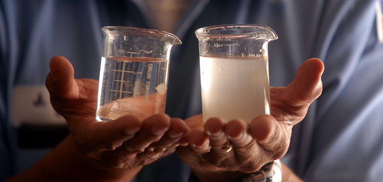
From 100 liters of seawater, 52 liters of drinking water and 48 liters of brine (brackish water) can be obtained. Although highly efficient and useful, desalination technology has still to be perfected, as it currently discharges brine into the sea, disrupting the marine ecosystem. To reduce this pollution and transform it into solid waste, we need to increase treatment and therefore energy consumption.
D. Wastewater
The country prides itself on reusing between 80% and 90% of its wastewater for agriculture. Treated wastewater used for irrigation is known as effluent. Israel’s effluent utilization rate is one of the highest in the world. Reclamation is carried out by 87 large wastewater treatment plants (WWTPs) that supply over 660 MCM per year. This represents around 50% of total water demand for agriculture and around 25% of the country’s total water demand. Israel aims to more than double the amount of effluent produced for the agricultural sector by 2050.
5. Water infrastructure projects

For Israel, acquiring water resources in a desert region, through technology, military conquest and/or diplomacy, was from the outset an imperative to meet the needs of a rapidly growing population and, in the eyes of the rest of the world, a demonstration of its sovereign power and its superiority.
This symbolism is particularly evident in the figure of the father of the Hebrew state, David Ben-Gurion (1886-1973), whose aim was to make the Negev desert in the south of the country « blossom ».
In his book Southwards (1956), Ben Gourion described his ambition:
« It is absolutely vital for the State of Israel, both for economic and security reasons, to go south: we must direct the water and rain to there, send the young pioneers there […] as well as the bulk of our budget resources to development. »
A. National Water Carrier of Israel (NWC)
OBJECTIVE: provide fresh water for Israel’s agriculture and growing population.
From 1959 to 1964, the Israelis built the National Water Carrier of Israel (NWC), the largest water project in Israel to date.
The first ideas appeared in Theodor Herzl‘s book Altneuland (1902), in which he spoke of using the springs of the Jordan for irrigation purposes and channeling seawater to generate electricity from the Mediterranean Sea near Haifa through the Beit She’an and Jordan valleys to a canal running parallel to the Jordan and Dead Sea.
In 1919, Chaïm Waizmann, leader of the World Zionist Organization, declared: « The whole economic future of Palestine depends on its water supply ».
However, he advocated incorporating the Litani Valley (in today’s southern Lebanon) into the Palestinian state.
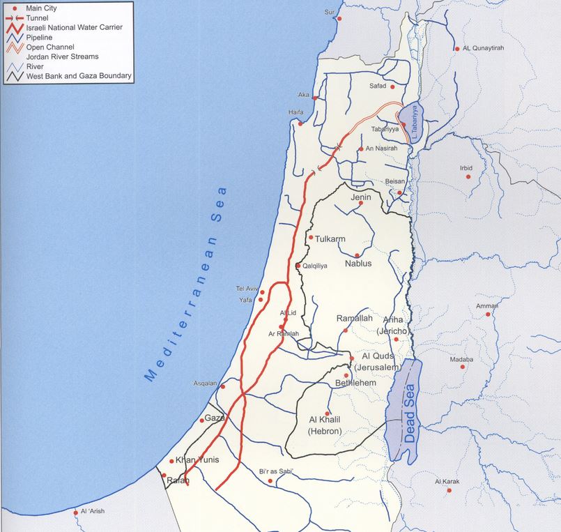
The NWC project was conceived as early as 1937, although detailed planning began after the recognition of Israel in 1948. In practice, the natural flow of the Jordan River is prevented by the construction of a dam, built south of Lake Tiberias. From there, water is diverted to the NWC, a 130 km-long system combining giant pipes, open channels, tunnels, reservoirs and large-scale pumping stations. The aim is to transfer water from Lake Tiberias to the densely populated center and the arid south, including the Negev desert.
When it was inaugurated in 1964, 80% of its water was allocated to agriculture and 20% to drinking water. By 1990, the NWC supplied half of Israel’s drinking water. With the addition of water from seawater desalination plants, it now supplies Tel Aviv, a city of 3.5 million inhabitants, Jerusalem (1 million inhabitants) and (outside wartime) Gaza and the occupied territories of the West Bank.
Since 1948, the area of irrigated farmland has increased from 30,000 to 186,000 hectares. Thanks to micro-irrigation (drip irrigation, including subsurface irrigation), Israeli agricultural production increased by 26% between 1999 and 2009, although the number of farmers fell from 23,500 to 17,000.
The Water War
In launching its NWC, Israel went it alone, while for the rest of the world, it was clear that diverting the waters of the Jordan River would give rise to sharp tensions with neighboring countries, particularly with Jordan and Syria, not to mention the Palestinians who have been largely excluded from the project’s economic benefits.
As early as 1953, Israel began the unilateral draining of Lake Hula (or Huleh), north of Lake Tiberias, leading to skirmishes with Syria.
In 1959, Israel kickstarted the NWC. The project was initially interrupted by a halt in American funding, as the Americans did not want to see violence escalate in the context of the Cold War.
It should be noted that, following the Suez crisis of 1956, the Soviet Union established itself in Syria as the protecting power of Arab countries against the « Israeli threat ». As part of the deployment of its naval presence in the Mediterranean, it obtained facilities for its fleet at Latakia in Syria.
However, Israel managed to quietly resume and continue the work on the NWC. Filling the system by pumping of Lake Tiberias began in June 1964 in utmost secrecy. When the Arab countries learned of this, their anger was great. In November 1964, the Syrian army fired on Israeli patrols around the NWC pumping station, provoking Israeli counter-attacks. In January 1965, the NWC was the target of the first attack by the Fatah (organization fighting for the liberation of Palestine) led by Yasser Arafat.
The Arab states finally recognized that they would never be able to stop the project through direct military action.
They therefore adopted a plan, the Headwater Diversion Plan immediately implemented in 1965, to divert water upstream from the tributaries of the Jordan River into the Yarmouk River (in Syria). The project was technically complicated and costly, but if successful would have diverted 35% of the water Israel intended to withdraw from the upper Jordan…
Israel declared that it considered this deviation of the water as an infringement of its sovereign rights. Relations degenerated completely and border clashes followed, with Syrian forces firing on Israeli army farmers and patrols. In July 1966, the Israeli air force bombed a concentration of earth-moving equipment and shot down a Syrian MiG-21. The Arab states abandoned their counter plan, but the conflict continued along the Israel-Syria border, including an Israeli air attack on Syrian territory in April 1967.
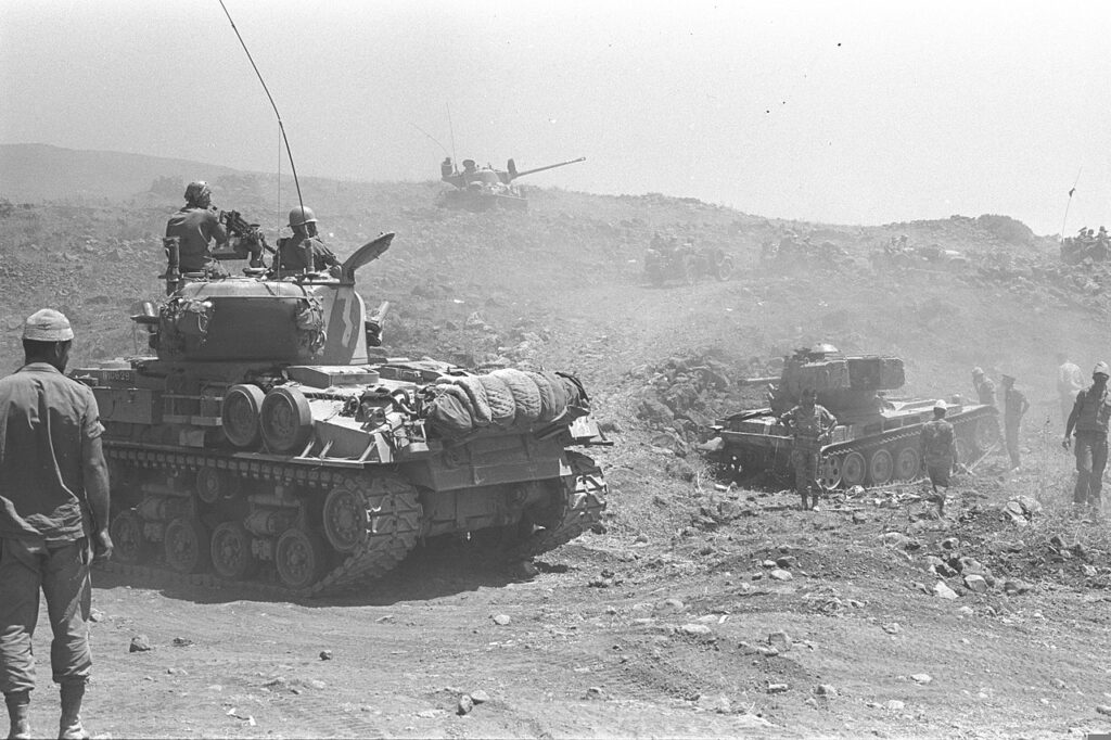
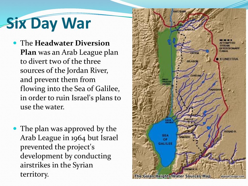
For many analysts, this was a prelude to the Six-Day War in 1967, when Israel occupied the Golan Heights to protect its water supply. The Six-Day War profoundly altered the geopolitical situation in the basin, with Israel now occupying not only the Gaza Strip and Sinai, but also the West Bank and the Golan Heights.
As French researcher Hervé Amiot explains:
« Israel went from being a downstream country to an upstream one, enabling it to gain control of vast resources. Israel now controlled 20% of the northern bank of the Yarmouk and occupied the Golan Heights, controlling all the small rivers flowing into Lake Tiberias. What’s more, total occupation of the West Bank gives them control over the important water tables ».
In fact, as early as 1955, between a quarter and a third of the water came from the groundwater in the south-western part of the West Bank. Today, the West Bank aquifers supply Israel with 475 million m³ of water, i.e. 25-30% of the country’s water consumption (and 50% of its drinking water).
Two months after the seizure of the occupied territories, Israel issued “Military Decree 92”, transferring authority over all water resources in the occupied territories to the Israeli army and conferring « absolute power to control all water-related matters to the Water Resources Officer, appointed by the Israeli courts ». This decree revoked all drilling licenses issued by the Jordanian government and designated the Jordan region a military zone, thus depriving Palestinians of all access to water while granting Israel total control over water resources, including those used to support its settlement projects.
Today, returning the Golan to Syria and recognizing the sovereignty of the Palestinian Authority over the West Bank seems impossible for Israel, given the Hebrew state’s increasing dependence on the water resources of these occupied territories. The exploitation of these resources will therefore continue, despite Article 55 of the Regulations of the IVth Hague Convention, which stipulates that an occupying power does not become the owner of water resources and cannot exploit them for the needs of its civilians…
B. Johnston Plan
OBJECTIVE: In the context of the Cold War, counter Nasser’s growing influence in the region. Offer regional stability by building dams and canals allowing a just sharing of water resources and providing water and energy for both Israel and Arab states welcoming « unfortunate » Palestinian refugees.
One might think that the United States tried very early on to prevent the situation from degenerating in such a predictable way. They tried to take into account Israel’s legitimate interest in securing access to water, the absolute key to its survival and development, while at the same time offering neighboring countries (Jordan, Syria and Lebanon) sufficient resources to accommodate the millions of Palestinians exiled from their homes following the Nakba.
Faced with the risk of conflict, as early as 1953 – years before Israel launched its NWC plan – the American government proposed its mediation to resolve disputes over the Jordan basin. The result was the « Jordan Valley Unified Water Plan » (known as the « Johnston Plan »), named after Eric Allen Johnston, president of the United States Chamber of Commerce and US President Dwight Eisenhower‘s water envoy.
More concretely, “The Unified Development of the Water Resources of the Jordan Valley Region,” was prepared at the request of the United Nations Relief and Works Agency for Palestine Refugees under the direction of the Tennessee Valley Authority.
On Oct. 13, 1953, Eisenhower’s Secretary of State John Foster Dulles, in a top secret letter instructed Johnston what his mission was all about and on Oct. 16, in a public statement Eisenhower explained:
« One of the major causes of disquiet in the Near East is the fact that some hundreds of thousands of Arab refugees are living without adequate means of support in the Arab states. The material wants of these people have been cared for through the United Nations Relief and Works Agency (UNRWA) … It has been evident from the start, however, that every effort must be made by the countries concerned, with the help of the international community, to find a means of giving these unfortunate people an opportunity to regain personal self-sufficiency.
« One of the major purposes of Mr. Johnston’s mission will be to undertake discussions with certain of the Arab states and Israel, looking to the mutual development of the water resources of the Jordan River Valley on a regional basis for the benefit of all the people of the area. …
« Such a regional approach holds a promise of extensive economic improvement in the countries concerned through the development of much needed irrigation and hydroelectric power and through the creation of an economic base on the land for a substantial proportion of the Arab refugees. It is my conviction that acceptance of a comprehensive plan for the development of the Jordan Valley would contribute greatly to stability in the Near East and to general economic progress of the region.«
This plan established the transboundary nature of the Jordan basin and proposed an equitable sharing of the resource, giving 52% of the water to Jordan, 31% to Israel, 10% to Syria and 3% to Lebanon.
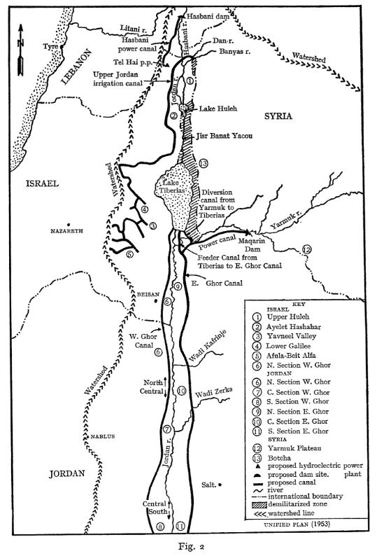
The plan, just as the Tennessee Valley Authority during FDR’s New Deal, was essentially based on building dams for irrigation and hydropower. The water was there and correctly managed, sufficient for the needs of the population at that time. Its main features were:
- a dam on the Hasbani River to provide power and irrigate the Galilee area;
- dams on the Dan and Banias Rivers to irrigate Galilee;
- drainage of the Huleh swamps;
- a dam at Maqarin on the Yarmouk River for water storage (capacity of 175 million m³) and power generation;
- a small dam at Addassiyah on the Yarmouk to divert its water toward both the Lake Tiberias and south along the eastern Ghor;
- a small dam at the outlet of Lake Tiberias to increase its storage capacity;
- gravity-flow canals along the east and west sides of the Jordan valley to irrigate the area between the Yarmouk’s confluence with the Jordan and the Dead Sea;
- control works and canals to utilize perennial flows from the wadis that the canals cross.
See details of the Johnston plan in this comprehensive article.
The project was validated by the technical committees of Israel and the Arab League, and did not require Israel to abandon its ambition to green the Negev desert. Unfortunately, however, the presentation of the plan to the Knesset in July 1955 did not result in a vote.
The Arab Committee approved the plan in September 1955 and forwarded it to the Council of the Arab League for final approval. Tragically, this institution also chose not to ratify it on October 11, because of its opposition to an act implying an implicit act of recognition of Israel that would prevent the return of the Palestinian refugees to their home… The mistake here was to isolate the water issue from a broader agreement on peace and justice as the foundation of mutual development.
Then, after the Suez Canal crisis in 1956, the Arab countries, with the exception of Jordan, hardened their stance towards Israel considerably, and henceforth opposed the Johnston plan head-on, arguing that it would amplify the threat posed by that country by enabling it to strengthen its economy. They also claim that increasing Israel’s water resources could only increase Jewish migration to the Hebrew state, thereby reducing the possibility of the return of Palestinian refugees from the 1948 war…
History cannot be rewritten, but the adoption of the Johnston Plan could well have prevented conflicts, such as that of 1967, which cost the lives of 15,000 Egyptians, 6,000 Jordanians, 2,500 Syrians and at least 1,000 Israelis.
C. Jordan’s response: the Ghor irrigation Canal
OBJECTIVE: construct the Jordanian section of the Johnston Plan to have water for irrigation and the capital of Jordan.

At almost the same time as Israel was completing its NWC, Jordan was digging the East Ghor irrigation canal between 1955 and 1964, starting at the confluence of the Yarmouk and Jordan rivers and running parallel to the latter all the way to the Dead Sea on Jordanian territory.
Originally, this was part of a larger project – the « Greater Yarmouk » project – which included two storage dams on the Yarmouk and a future “Western Ghor Canal” on the west bank of the Jordan. The latter was never built, as Israel took the West Bank from Jordan in the 1967 Six-Day War.
In effect, by diverting the waters of the Yarmouk to fill up its own canal, Jordan secured water for its capital Amman and its agriculture, but of course, contributed reducing the waters of the Jordan River.
In Jordan, the Jordan’s river watershed is a region of vital importance to the country. It is home to 83% of the population, the main industries and 80% of irrigated agriculture. It is also home to 80% of the country’s total water resources.
Overall, the Hashemite kingdom is one of the world’s most water-poor countries, with 92% of its territory desert. While Israel has 276 m³ of natural freshwater available per capita per year, Jordan has just 179 m³, more than half of which comes from groundwater.
The UN considers that a country with less than 500 m³ of freshwater per capita per year suffers from « absolute water stress ». Added to this is the fact that since the start of the Syrian civil war, Jordan has welcomed nearly 1.4 million refugees onto its soil, in addition to its 10 million inhabitants.
The East Ghor Canal was designed in 1957 and built between 1959 and 1961 competing with Israel’s NWC. In 1966, the upstream section as far as Wadi Zarqa was completed. The canal was then 70 km long and was extended three times between 1969 and 1987.
The United States, through the U.S. Agency for International Development (USAID), financed the initial phase of the project, after obtaining explicit assurances from the Jordanian government that Jordan would not withdraw more water from the Yarmouk than had been allocated to it under the Johnston Plan. They were also involved in the subsequent phases.
Waterworks in the region are often named after great political figures. The East Ghor Canal was named « King Abdallah Canal (KAC) » by Abdalla II after his great-grandfather, the founder of Jordan. At the time of the peace treaty with Israel in 1994, the two countries shared the flow of the Jordan, and Jordan agreed to sell its water from Lake Tiberias.
D. Mediterranean – Dead Sea Aqueduct
OBJECTIVE: generate hydro-electricity and make Israel independant from Arab oil and gas supplies.
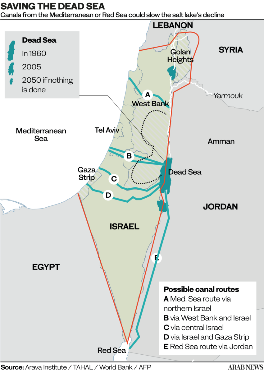
A: Crossing solely Israelian territory;
B and C: Crossing Israel and West Bank (shortest, 70 km);
D. Crossing Gaza and Israel;
E. Crossing only Jordan (longest, 200 km).
The idea of a Dead Sea-Mediterranean Canal was first proposed by William Allen in 1855 in a book entitled The Dead Sea – A new route to India. At the time, it was not known that the level of the Dead Sea was far below that of the Mediterranean, and Allen proposed the canal as an alternative to the Suez navigation Canal.
Later, several engineers and politicians took up the idea, including Theodor Herzl in his 1902 short story Altneuland. Most early projects were based on the left bank of the Jordan, but a modified form, using the right bank (West bank), was proposed after 1967.
After extensive research, German engineers Herbert Wendt and Wieland Kelm proposed not a navigable canal, but an aqueduct consisting essentially of an overhead gallery running West-East, linking the Mediterranean to the Dead Sea.
Their 1975 detailed project study Depressionskraftwerk am Toten Meer – Eine Projektstudie, on how to use the difference of water levels between the Mediterranean sea (level 0) and the Dead Sea (- 400 m) for power generation was the subject of a first publication in the German journal Wasserwirtschaft (1975,3).
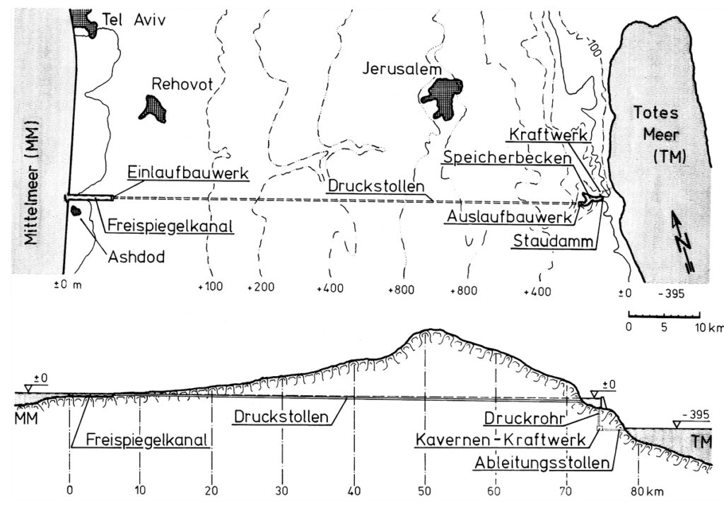
The diagram indicates the system operates as follows:
- The seawater intake is at Ashdod.
- An open channel allows the water to flow by gravity for 7 km.
- From there, the pressurized water travels through a 65 km-long hydraulic gallery;
- The water arrives in a 3km-long reservoir created by a dam on the edge of the steep descent to the Dead Sea. At that point, the water can be used to cool a thermal or nuclear power plant, the heat from which can be used for industrial or agricultural purposes.
- Through a shaft running from the bottom of the reservoir, the water descends a steep 400 metres.
- There, it powers three turbines, each producing 100 MWe.
- Finally, via an evacuation gallery, the seawater reaches the Dead Sea.
However, since the project was elaborated exclusively by Israel and without any consultation with its Jordanian, Egyptian and Palestinian neighbors, the project ran against a wall of political opposition.
Of course, as with any large scale infrastructure projects, many things needed to be adapted, including tourist equipment, roads, hotels, Jordanian potash exploitation, Palestinian farmland, etc.
Questions were also raised about (very infrequent) potential earthquakes and the difference of salinity of water from the Mediterranean and the Dead Sea.
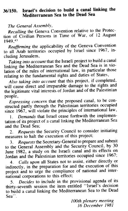
On Dec. 16, 1981, the UN General Assembly, arguing the canal project « will violate the principle of international law » adopted Resolution 36-150.
That resolution requested the UN Security Council « to consider initiating measures to halt the execution of this project » and calling « upon all States not to assist, either directly or indirectly, in the preparation for and the execution of this project. »
The request, in article 3, to submit a study was fulfilled. The report, not really convincing, details various objections but doesn’t call into question the technical feasability of the project.
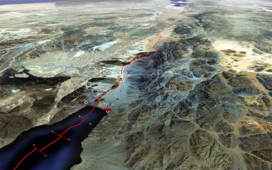
E. Red Sea – Dead Sea Water Conveyance
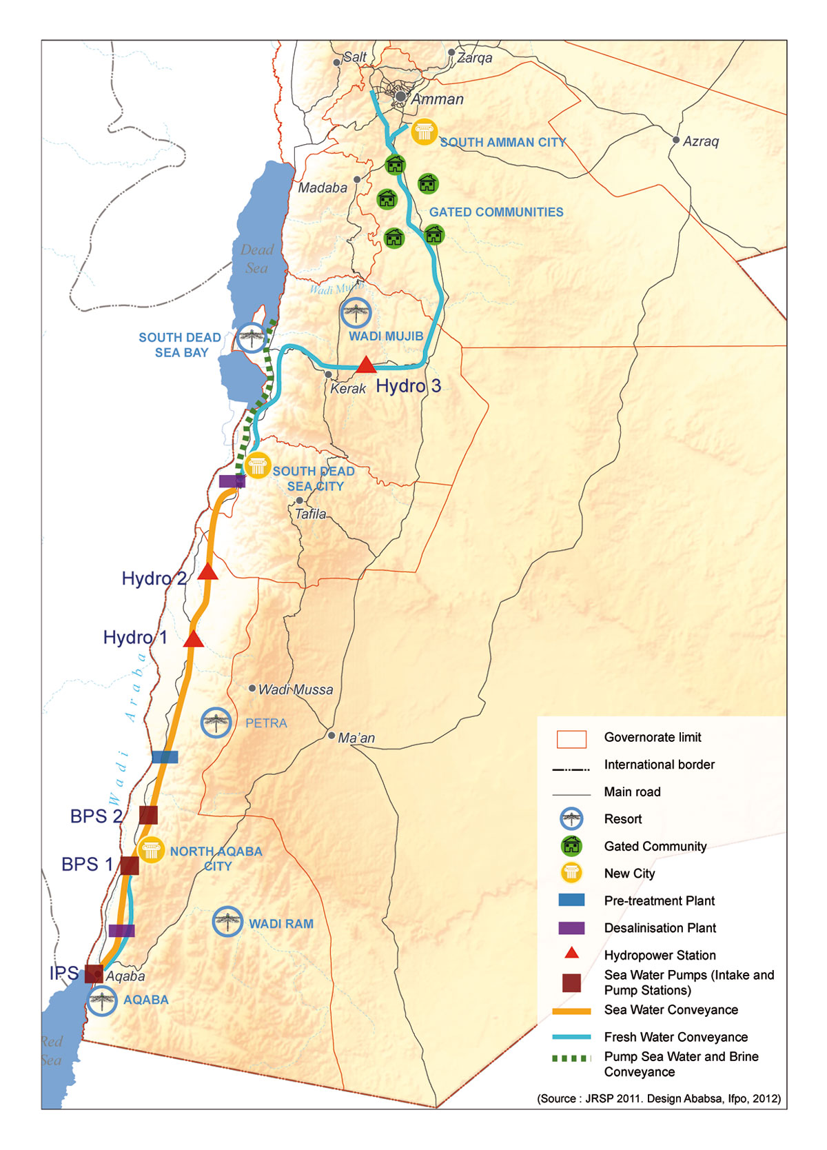
OBJECTIVES: Build a desalination plant close to the Dead Sea to provide fresh water to Jordan, Israel and Palestine by desalinating seawater arriving via a pipeline from the Red Sea. Use the brine to refill the Dead Sea. Use the watersharing as a model for peaceful mutual beneficial cooperation. Make the project the heart of a development corridor.
In the framework of the peace treaty between Israel and the Hashemite Kingdom of Jordan the integrated development Master Plan for the Jordan Rift Valley (JRV) was studied in the mid 1990’s.
The Red Sea – Dead Sea Canal (RSDSC) was considered to be one of the most important potential elements for implementing this Master Plan. The principal development objective of the RSDSC was to provide desalinated drinking water for the people of the area.
On October 17, 1994, then Israeli Prime Minister Yitzhak Rabin and King Hussein of Jordan validated the draft peace treaty between their two countries in Amman, after reaching agreement on the last two points in dispute – the water issue and border demarcation.

On November 26, the Israeli-Jordanian peace treaty was signed with great fanfare in the Arava Valley, between the Red Sea and the Dead Sea, by the prime ministers of the two countries, in the presence of US President Bill Clinton, whose country had helped bring the negotiations between Jerusalem and Amman to a successful conclusion.
This created the condition where the old idea of linking the Red Sea with the Dead Sea, a project renamed and supported by Shimon Peres as the « Peace Canal », could come back on the table.
Former Israeli water commissioner Professor Dan Zaslavsky, who opposed the project on cost grounds, wrote in the Jerusalem Post in 2006 about Peres’ obstinacy. To listen to the scientists, Peres summoned five of them. Each had to present his objections in a few minutes.
« At one point, Peres got up and said, ‘Excuse me. Don’t you remember that I built the nuclear reactor in Dimona? Do you remember that everyone was against it? Well I was right in the end. And this will prove to be the same thing! » And with that, Zaslavsky said with a flourish, « he left! »
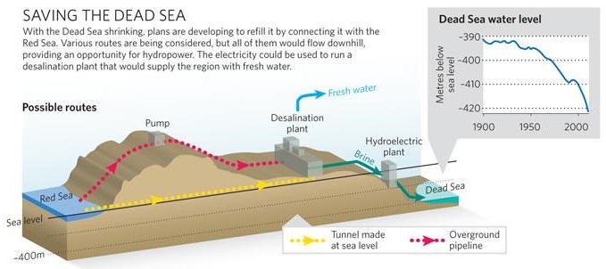
The Dead Sea
For millennia, the Dead Sea was filled with fresh water from the Jordan River, via Lake Tiberias. Over the last fifty years, however, it has lost 28% of its depth and a third of its surface area. Its water level is falling inexorably, at an average rate of 1.45 meters per year. Its high salinity – over 27%, compared with the average for oceans and seas of 2-4% – and a level 430 meters below sea level, has always fascinated visitors and provided therapeutic benefits. Stretching 51 kilometers long and 18 kilometers wide, it is shared by Israel, Jordan and the West Bank.
The over-exploitation of upstream water resources (the National Aqueduct in Israel, the Ghor Canal in Jordan), together with potassium mining, is the cause of the sand desert which, if nothing is done, will continue to replace the Dead Sea.
If the Dead Sea needs the Jordan River, the Jordan River needs Lake Tiberias, from which it takes its source. However, the lake too has been affected by drastic drops in its water level in recent years, triggering a vicious circle between the three systems (Lake Tiberias, Jordan River and Dead Sea).
Aqueduct
In response, at the end of 2006, the World Bank and Agence Française de Développement (AFD) assisted Israel and Jordan in the design of a colossal project to link the Dead Sea to the Red Sea via a 180-kilometer mainly underground pipeline.
In the end, the project for an aqueduct starting from the Red Sea and built entirely on Jordanian territory was chosen, with the signing of a tripartite agreement between Israelis, Jordanians and Palestinians in December 2013.
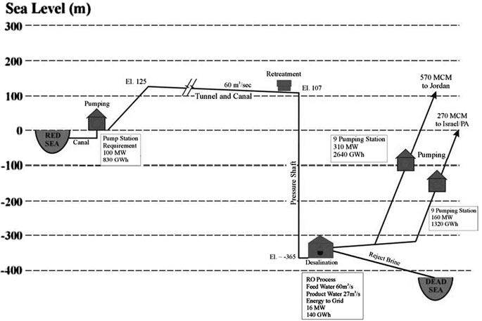
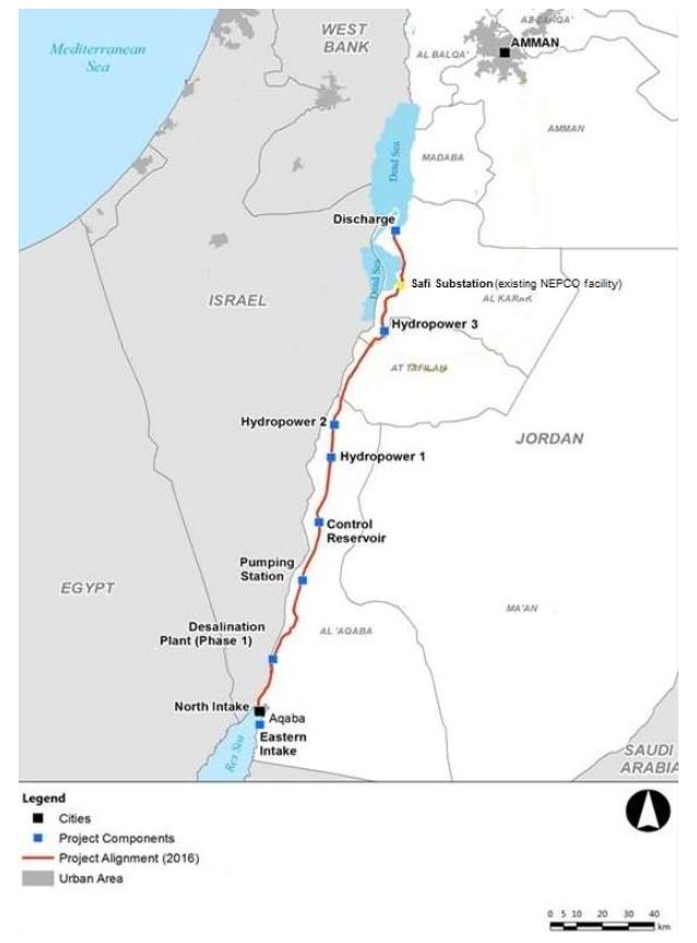
- Sea intake and pumping station
The seawater is pumped to +125 m above sea level at the Red Sea. - Pressure pipeline
The first part of the conveyance system transmits the seawater to the planned elevation. The length is 5 km from Aqaba (3% of the whole alignment). - A tunnel and canal conveyance system
Seawater is transmitted to the regulating and pretreatment reservoirs with a design flow of 60 m3 /s. A 121 km tunnel with 7 m diameter and 39 km canal were designed. - Regulating and pre-treatment reservoirs
Several reservoirs were designed at +107 m at Wadi G’mal at the southeastern margin of the Dead Sea. - Desalination plants
The 2 desalination plants are designed to operate by using the process of hydrostatically supported reverse osmosis to provide desalinated seawater. The main plant will be located at Safi at 365 m below the sea level with a water column of 475 m. - Fresh water
The project will produce around 850 MMC of fresh water per year, to be shared between Jordan, Israel and Palestine, the three countries that manage the Dead Sea. For the transmission of the water to Amman a double pipeline of 200 km with 2.75 m diameter was designed with nine pumping stations for the uplift of 1,500 m. For the transmission to Hebron a double pipeline of 125 km with an elevation difference of 1,415 m was designed. - The brine
The brine reject water will be conveyed from the desalination plant via a 7 km canal to the Dead Sea. 1,100 MMC per year of brine reject water will enter the Dead Sea. - Electricity generation
As the brine runs through the tunnel and canal, the turbines of one or more hydroelectric power plants will generate around 800 megawatts of electricity to partially offset the electricity consumed by pumping; - Three new cities will be built: North Aqaba city in northern Aqaba, South Dead Sea City, close to the desalination plant south of the Dead Sea, and South Amman City (see map at the beginning of this section).
In terms of environmental impact, scientists have expressed concern that mixing the brine (rich in sulfate) from the desalination plants with the Dead Sea water (rich in calcium) could cause the latter to turn white. It would therefore be necessary to proceed with a gradual water transfer to observe the effects of water transfer in this particular ecosystem.
Not enough to stabilize the level of the Dead Sea, but a first step to start slowing down its drying up, emphasized Frédéric Maurel, in charge of this project for AFD, in 2018. « We also need to use water more sparingly, both in agriculture and in the potash industry, » he stressed.
Political will?
In 2015, as a supplement to the program, agreements had been reached on reciprocal water sales: Jordan would supply drinking water to Israel in the south, which in return would increase its sales of water from Lake Tiberias to supply northern Jordan. And the Palestinians would also receive additional water supplies from Israel. By the end of 2016, five consortia of companies had been shortlisted.
In 2017, the European Investment Bank produced a 264 page detailed study to support the plan.
On the Israeli side, saving the Dead Sea is a necessity to maintain seaside tourism and thermalism. It is also a lever to guarantee its hydraulic control over the West Bank, as Israel does not trust the Palestinian Authority to manage water. Honest elements of the Hebrew state are aware of the peacemaking potential of this project, and need a stable partner in the region. Jordan, for its part, was by far the most interested in this project, given its critical situation.
In 2021, Jordan decided to put an end to the joint water pipeline project, believing that there was « no real desire on the part of the Israelis » for the plan, which had stagnated for several years, to go ahead.
To face its growing needs, Jordan has decided to build its own desalination plant directly on the Red Sea. The Aqaba-Amman Water Desalination and Conveyance Project will take water from the Red Sea at the Gulf of Aqaba in the south, desalinate it, and channel it 450 kilometres north to the capital Amman and its surrounding area, supplying a desperately needed 300 million cubic metres of water a year. Studies are complete and construction will start on July 2024. The plant will be powered with solar energy.
In 2022, Jordan, the UAE and Israel signed a memorandum of understanding (MoU) to continue feasibility studies for two interconnected projects: establishing the water desalination station at the Red Sea (Prosperity Blue) and establishing a solar power plant in Jordan (Prosperity Green). However, due to the ongoing war against Gaza and the rejection of the Jordanian public regarding the agreement’s signing, the Jordan government announced the suspension of the agreement.
The Dead Sea might slowly reappear
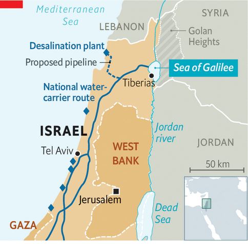
With huge desalinization capacities in hand, Israel adopted in 2023 the National Carrier Flow Reversal Project to return water to its natural resources, in particular to Lake Tiberias, the very source of freshwater for its entire national water system.
Lake Tiberias, as we have seen, is therefore a national treasure, a centerpiece of tourism, agriculture and, as we have seen, geopolitics.
According to Dodi Belser, Director of Innovation at water state giant Mekorot, if Israel wants to increase the water it sends to its Jordanian neighbors and to protect its reservoir, it’s vital to retain the lake’s water level. Currently Israel taps 100 million cubic meters of water from Lake Tiberias to send to Jordan, and did so even during the drought years of 2013 to 2018.
Increase resilience to climate chaos and preparing eventual futur water sharing, gave birth to the idea to pump desalinated water into the Lake Tiberias, up to 120 million cubic meters a year until 2026. That is happening right now.
It can partly increase the level of the Jordan river and therefore the water arriving into the Dead Sea. But the salt in the Dead Sea comes from the waters of the Jordan River. Every year, the famous river brings it some 850,000 tonnes of salt.
F. Turkish water sales
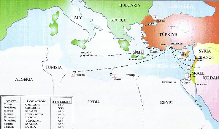
Turkye, a veritable « water tower » in the region, has long dreamed of exporting its water to Israel, Palestine, Cyprus and other Middle Eastern countries at a premium.
The most ambitious of these projects was President Turgut Ozal‘s « Peace Water Pipeline » in 1986, a $21 billion project to pipe water from the Seyhan and Ceyhan rivers to cities in Syria, Jordan and the Arab states of the Gulf.
In 2000, Israel was strongly considering purchasing 50 million m3 per year for 20 years from the Manavgat river near Antalya, but since November 2006, the deal has been put on hold.

The Manavgat project, technically completed in mid-March 2000, was a pilot project.
The complex on the Manavgat river – which rises in the Taurus mountains and flows into the Mediterranean between Antalya and Alanya – includes a pumping station, a refining center and a ten-kilometer-long canal. The aim was then to transport this fresh water by 250,000-ton tankers to the Israeli port of Ashkelon for injection into the Israeli NWC.
Eventually, Jordan was also interested in Turkey’s aquatic manna. A second customer downstream of its network would enable Israel to share costs. Another possibility would be to transport the water via a water pipeline linking Turkey to Syria and Jordan, and ultimately to Israel and Palestine if the latter could reach an agreement with its partners. The Palestinians, for their part, have been looking for a donor country to subsidize freshwater imports by tanker to Gaza.
The Manavgat project is not the only one through which Ankara hopes to sell its water. In 1992, Suleyman Demirel, then Prime Minister, expressed a credo that went viral: « Turkey can use the waters of the Tigris and Euphrates rivers as it sees fit: Turkey’s water resources belong to Turkey, just as oil belongs to Arab countries.”
The countries downstream of the two rivers – Iraq and above all Syria – immediately protested. For them, the multiple dams that Ankara plans to build on the region’s main freshwater sources for irrigation or power generation are simply a way for the heir to the Ottoman Empire to assert its authority over the region.
Whatever Ankara’s real ambitions, the country has a real treasure trove at its disposal, especially given the dwindling resources of neighboring countries.
In the end, since November 2006, Israeli supporters of desalination have objected to the price of Turkish water and questioned the wisdom of relying on Ankara, whose government is critical of Israeli policies. Desalination or importation? The choice is a Cornelian one for Israel. And an eminently political one, since it comes down to knowing whether to stick to positions based on self-sufficiency or whether to play the regional cooperation card, which amounts to betting on trust…
G. Hidden defects and non-implementation of Oslo
The recognition of Israel by Yasser Arafat – leader of the Palestinian Liberation Organisation –, and the election of Yitzhak Rabin as Israel’s Prime minister in 1992 opened new opportunities for peace and cooperation. The Oslo accords they signed established the Palestinian Authority and determined temporary groundwater allocations from the West Bank to Israel and Palestine. In the declaration, both parties agreed on the principle of “equitable utilisation” between Palestinians and Israelis.
The collapse of mutual trust following the assassination of Rabin in November 1995 and the subsequent election of Benjamin Netanyahu, who had been highly critical of Oslo, negatively affected cooperation on water.
In 2000, during the first six months of the second Intifada, there was hardly any contact between both sides regarding water issues. But with reason coming back, despite the conflict, Israeli and Palestinian leaders committed themselves to separating the water issue from violence and reactivated cooperation over water.
In 2004, Israel reportedly proposed a plan to build a desalination plant in order to increase the quantity of freshwater available and to channel desalinated water to the West Bank. Fearing that this might in effect imply a renunciation to Palestinian water claims on the Mountain aquifer (75% of which is allocated to Israel even though the Aquifer is on Palestinian land), the Palestinians rejected this solution.
The Oslo Accords, signed by Israel and the Palestine Liberation Organization (PLO) in 1993, although stipulating that « Israel recognizes the water rights of Palestine », in reality allowed Israel to continue controlling the region’s water sources… while awaiting a resolution to the conflict. Oslo II provided for the postponement of negotiations on water rights until those on permanent status, as well as on the status of Jerusalem, refugees’ right of return, illegal settlements, security arrangements and other issues.
But final status talks, scheduled to take place five years after the implementation of the Oslo Accords (in 1999, as planned), have not yet taken place.
The Oslo Accords also provided for the creation of a water management authority, and their « Declaration of Principles » stressed the need to ensure « the equitable use of common water resources, for application during the interim period [of the Oslo Accords] and thereafter ».
Hence, for decades, Israel has perpetuated a principle of water distribution that existed before the Oslo Accords were signed, allowing Israelis to consume water at will while limiting Palestinians to a predetermined 15% share.
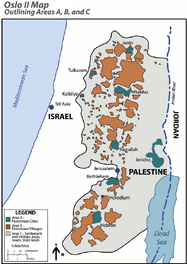
The Oslo agreements did not take into account the division of the West Bank into zones A, B and C when it came to organizing water distribution between Israel and the Palestinians.
Israel was finally granted the right to control water sources, even in PA-controlled areas A and B.
Most water sources were already located in Area C, which is entirely controlled by Israel and comprises almost 61% of the West Bank.
On the ground, Israel has connected all the settlements built in the West Bank, with the exception of the Jordan Valley, to the Israeli water network. The water supply to Israeli communities on both sides of the Green Line is managed as a single system, under the responsibility of Israel’s national water company, Mekorot.
While the Oslo Accords allowed Israel to pump water from areas under its control to supply settlements in the occupied West Bank, they also prevent the PA from transferring water from one area to another in those it administers in the West Bank. Israel has disavowed most of the provisions of the Oslo Accords, but remains committed to those relating to water.
A member of the Palestinian delegation that signed the Oslo Accords, wishing to remain anonymous, tells Middle East Eye magazine that the delegation’s lack of expertise at the time resulted in the signing of an agreement that
« placed the fate of Palestinian access to water in Israel’s hands (…) Most Palestinian water experts withdrew from the negotiations at the outset of the Oslo process, as they were not satisfied with the way the negotiations were being conducted », he stressed. « As for the political leaders, their main objective was to reach an agreement. »

In practice, this means that Palestinians in the occupied West Bank are at the mercy of the Israeli occupation when it comes to their water supply.
Inequalities in terms of access to water in the West Bank are glaring, as shown by the Israeli NGO B’Tselem in a report entitled Parched, published in May 2023.
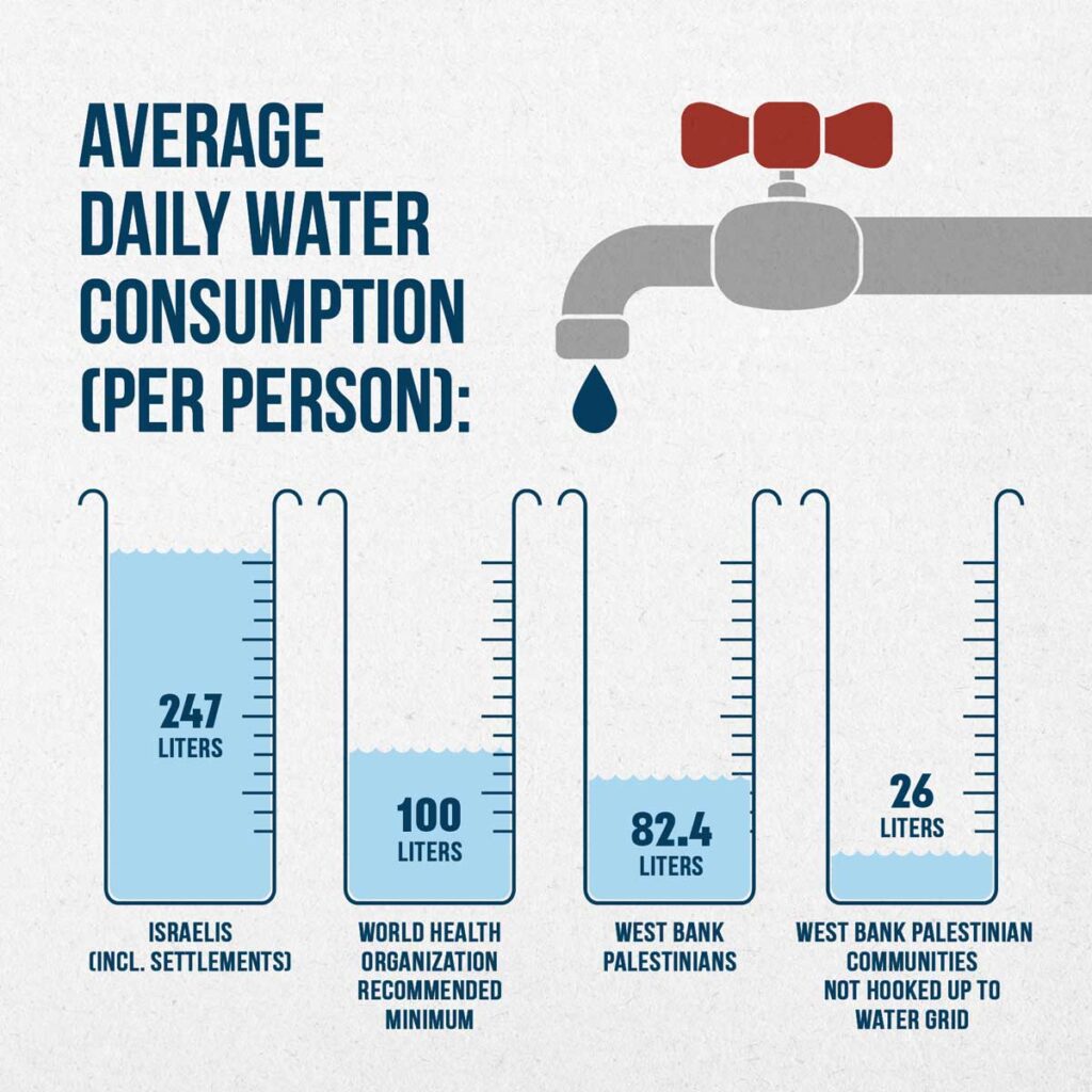
In 2020, each Palestinian in the West Bank consumed an average of 82.4 liters of water per day, compared with 247 liters per person in Israel and the settlements.
This figure drops to 26 liters per day for Palestinian communities in the West Bank that are not connected to the water distribution network. 36% of West Bank Palestinians have year-round access to running water, compared with 100% of Israelis, including settlers.
The Palestinian Authority, which claims more water, points out that Palestinian agriculture plays a major role in the economy of the Occupied Territories (15% of GDP, 14% of the working population in 2000). In comparison, Israeli agriculture, while far more productive, employs 2.5% of the working population and produces 3% of GDP.
Added to this the fact that the arable land recognized by Israel under the Oslo Accords as totally or partially autonomous to the Palestinians is located in the limestone uplands, where access to water is difficult, since it is necessary to dig deep to reach the water table.
What’s more, in Israel and the settlements, 47% of land is irrigated, compared with only 6% of Palestinian land. The Palestinian Authority is currently demanding rights to 80% of the mountain aquifer, which Israel cannot conceive of.
Myth of Thirsty Palestinian
Israeli spokespeople, such as Akiva Bigman in his article titled « The Myth of the Thirsty Palestinian » have three answers ready to pull out when they are confronted with the water shortages in West Bank Palestinian towns:
1) “Because the PA does not properly maintain its water system, it suffers from a 33 percent rate of water loss, mostly due to leakage; in contrast to an 11 percent loss from the Israeli system.”
Answer: leakage varies from 20 to 50% in the USA, far above the rate of poor Palestine.
2) “40 potential drilling sites in the Hebron area were identified and approved by the Israeli-Palestinian Joint Water Committee; but in the two decades since then, drilling has taken place in only three places, and this is in spite of substantial funding provided to the PA by donor nations.”
One can ask where the money went. And yes, in reality, at the end of the day, for various technical reasons and unexpected drilling failures in the eastern basin of the aquifer (the only place the agreement allows the Palestinians to drill), the Palestinians ended up producing less water than the agreements set.
3) Israel has in its great generosity “doubled the amount of water it supplies to the Palestinians, compared to what was called for in the Oslo Accords.”

True. However, Oslo didn’t set a limit to the amount of water Israel can take, but limited the Palestinians to 118 MCM from the wells that existed prior to the accords, and another 70-80 MCM from new drilling. According to the Israeli NGO B’Tselem, as of 2014 the Palestinians are only getting 14 percent of the aquifer’s water. That is why the Israeli state company Mekorot (obeying to government directives) is selling the Palestinians the double of water stipulated in the Oslo Agreement – 64 MCM, as opposed to 31 MCM. 64 + 31 = 95 MCM in total, to be compated with current consumption by Palestinians in the West Bank: 239 MCM of water in 2020 of which 77.1 of them purchased from Israel.
A final detail that speaks volumes: Palestinians are charged the price of drinking water for their agricultural water while Jewish settlers benefit from agricultural tariffs and subsidies. The justification being that the Jewish settlers have invested in expensive irrigation techniques such as desalination
H. Ben Gurion Navigation Canal
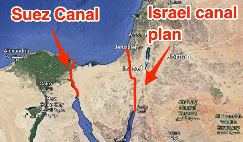
At the end of 2023, the idea of the Ben-Gurion navigation Canal project was revived in the media. The canal would link the Gulf of Aqaba (Eilat) in the Red Sea to the Mediterranean Sea, passing through Israel to terminate in or near the Gaza Strip (Ashkelon). This is an Israeli alternative to the Suez Canal, which became topical in the 1960s following Nasser’s nationalization of Suez.
The first ideas for a connection between the Red Sea and the Mediterranean appeared in the mid-19th century, on the initiative of the British, who wanted to link the three seas: the Red, the Dead and the Mediterranean. As the Dead Sea lies 430.5 meters below sea level, such an idea was not feasible, but it could be realized in another direction. Frightened by Nasser’s nationalization of Suez, the Americans considered the option of the Israeli canal, their loyal ally in the Middle East.
In July 1963, H. D. Maccabee of Lawrence Livermore National Laboratory, under contract to the U.S. Department of Energy, wrote a memorandum exploring the possibility of using 520 underground nuclear explosions to help dig some 250 kilometers of canals across the Negev desert. The document was classified until 1993. « Such a canal would constitute a strategically valuable alternative to the present Suez Canal and would probably contribute greatly to the economic development of the surrounding region, » says the declassified document.
The idea of the Ben Gurion Canal resurfaced at the same time as the signing of the so-called « Abraham Agreements » between Israel and the United Arab Emirates, Bahrain, Morocco and Sudan.
On October 20, 2020, the unthinkable happened: Israel’s state-owned Europe Asia Pipeline Company (EAPC) and the UAE’s MED-RED Land Bridge signed an agreement to use the Eilat-Ashkelon pipeline to transport oil from the Red Sea to the Mediterranean, avoiding de facto the Suez Canal.
On April 2, 2021, Israel announced that work on the Ben Gurion Canal was due to start in June of the same year. But this has not been the case. Some analysts interpret the current Israeli reoccupation of the Gaza Strip as an event that many Israeli politicians were waiting for to revive an old project.
A closer look at the planned route shows that the canal starts at the southern edge of the Gulf of Aqaba, from the port city of Eilat, close to the Israeli-Palestinian border, and continues through the Arabah valley for around 100 km, between the Negev mountains and the Jordanian highlands. It then turns west before the Dead Sea, continues through a valley in the Negev mountain range, then turns north again to bypass the Gaza Strip and reach the Mediterranean Sea in the Ashkelon region.
The project’s promoters argue that their canal would be more efficient than the Suez Canal because, in addition to being able to accommodate a greater number of ships, it would allow the simultaneous two-way navigation of large vessels thanks to the design of two canal arms.
Unlike the Suez Canal, which runs along sandy banks, the Israeli canal would have hard walls that require almost no maintenance. Israel plans to build small towns, hotels, restaurants and cafés along the canal.
Each proposed branch of the canal would be 50 meters deep and around 200 meters wide. It would be 10 meters deeper than the Suez Canal. Ships 300 meters long and 110 meters wide could pass through the canal, corresponding to the size of the world’s largest ships.
If completed, the Ben-Gurion Canal would be almost a third longer than the Suez Canal, which measures 193.3 km, or 292.9 km. Construction of the canal would take 5 years and involve 300,000 engineers and technicians from all over the world. Construction costs are estimated at between $16 and $55 billion. Israel stands to gain $6 billion a year.
Whoever controls the canal, and apparently it can only be Israel and its allies (mainly the USA and Great Britain), will have enormous influence over international supply chains for oil, gas and grain, as well as world trade in general.
Israel argues that such a project would undermine the power of Egypt, a country strongly allied with Russia, China and the BRICS and therefore « a threat » to the West! With the depopulation of Gaza and the prospect of total Israeli control over this tiny territory, some Israeli politicians, including Netanyahu, are once again salivating over the prospect of such a project.
As Croatian analyst Matia Seric pointed out in Asia Review in November 2023:
« If realized, the Ben Gurion Canal would bring about a tectonic change as it would overshadow the Suez Canal. The project would launch Israel into the center of world shipping and world trade. Egypt would lose its monopoly on the shortest route between Africa, Asia and Europe. The emergence of an alternative Israeli channel would have a devastating impact on the Egyptian economy. President el-Sisi may regret putting his trust in Israel and Western governments above the well-being of the two million Palestinians in Gaza. Egypt, apart from formally condemning the mass crimes committed by Israeli forces against the civilian Palestinian population, has done little to prevent Israeli wrongdoing, which some call genocide. Israeli Prime Minister Benjamin Netanyahu has repeatedly expressed support for the idea of the canal along with the idea of building a high-speed railway from Eilat to Beersheba. Realizing, or at least starting, this project could redeem Netanyahu from his many mistakes during his long reign, including the intelligence and military failures that facilitated the October 7 attack by Hamas. »
I. Oasis Plan
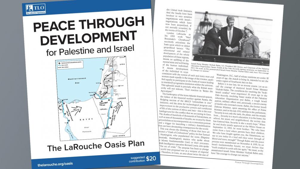
It is in the light of all these failures that the fundamental contribution of the « Oasis Plan » proposed by the American economist Lyndon LaRouche (1922-2019) becomes apparent.
In 1975, following talks with the leaders of the Iraqi Baath Party and sane elements of the Israeli Labor Party, the American economist LaRouche saw his Oasis Plan as the basis for mutual development to the benefit of the entire region.
Instead of waiting for « stability » and « lasting peace » to arrive magically, LaRouche proposed and even launched projects in the interests of all, and « recruited » all partners to participate fully, first and foremost in their own interests, but in reality in the interests of all.

LaRouche’s « Blue Peace » Oasis plan, to be put on the table of diplomatic negotiations as the « spine » of a durable peace agreement », includes:
- Israel’s relinquishment of exclusive control over water resources in favor of a fair resource-sharing agreement between all the countries in the region;
- The reconstruction and economic development of the Gaza Strip, including the Yasser Arafat International Airport (inaugurated in 1998 and bulldozered by Israeli in 2002), a major seaport backed up by a hinterland equipped with industrial and agricultural infrastructure.
- A floating, underwater or off-shore desalination plant will be stationed in front of Gaza.
- The construction of a fast rail network reconnecting Palestine (including Gaza) and Israel to its neighbors;
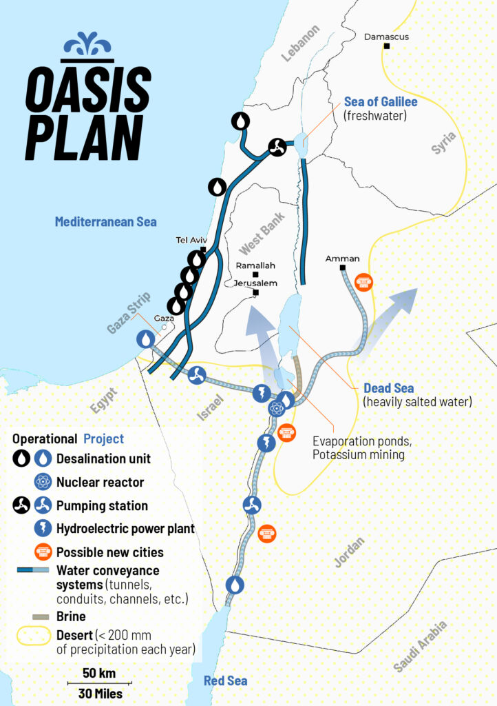
- The construction, for less than 20 billion US dollars of both the Red-Dead and the Med-Dead water conveyance system composed of tunnels, pipelines, water galeries, pumping stations, hydro-power units and nuclear powered desalination plants.
- Salted sea water, arriving at the Dead Sea, before desalination, will « fall » through a 400 meter deep shaft and generate hydro-electricity.
- Following desalination, the fresh water will go to Jordan, Palestine and Israel; the brine will refill and save the Dead Sea.
- The nuclear powered desalination plant will produce heat and electricity with « hybrid desalination » combining evaporation and Reverse Osmosis (RO) ;
- The industrial heat of the Molten Salt (MSR) high temperature reactors (HTR), will also be tapped for industrial and agricultural purposes;
- The reservoirs of the water conveyance systems will also function as a Pumped Storage Power Plant (PSPP), essential for regulating the region’s power grids;
- Part of the seawater going through the Med-Dead Water conveyance system will be desalinated in Beersheba, the « capital of the Negev » whose population, with new fresh water supplies, can be doubled.
- New cities and « development corridors » will grow around the new water conveyance systems.
- Israel’s Dimona nuclear center and power plant (currently a military reactor and medical nuclear waste treatment center) can form the basis to create a civilian nuclear program and contribute to the construction of nuclear desalination plants. Jordan can supply the uranium.
- US and Israeli plans to prepare the housing of 500,000/1 million people in the Negev exist but should be entirely reconfigured in terms of both scope and intent. They cannot be a mere extension of exclusively Jewish settlements, but should offer the opportunity to all Israeli citizens, in peaceful cooperation with the Bedouins who live there, the Palestinians and others, to roll back a common enemy: the desert.
- The policy of illegal settlements in the West Bank shall be halted. Settlers will be encouraged (through taxation, etc.) to relocate to the Negev, where they, in a shared effort with the Bedouins, Palestinians and others, can take up productive jobs and make the desert bloom (62% of Israeli territory).
PS: The Oasis Plan plan aims to bring peace to all through mutual development. It has nothing to do with Netanyahu’s Ben-Gurion canal project, a megalomaniac plan for a navigation canal connecting the Red Sea with the Mediterranean aimed to compete with the Suez Canal.
Alvin Weinberg, Yitzhak Rabin and Lyndon LaRouche
LaRouche proposed coupling hydrological, energy, agricultural and industrial infrastructures. These agro-industrial complexes, built around small high-temperature nuclear reactors, were called « nuplexes », a concept put forward in the post-war period by the American scientist Alvin Weinberg, head of the Oak Ridge Laboratories in Tennessee (ORNL) and co-inventor of several types of nuclear reactor, notably the molten-salt line using thorium as fuel (and therefore without the production of weapons-grade plutonium).
In chapter 8 of his autobiography, Weinberg recounts how ORNL, « embarked on a great enterprise: desalinating the sea with cheap nuclear power », with « multi-purpose » plants, « producing water, electricity and process heat at the same time ». The assertion that this was possible, Weinberg reports, « caused a stir within the Atomic Energy Commission ».
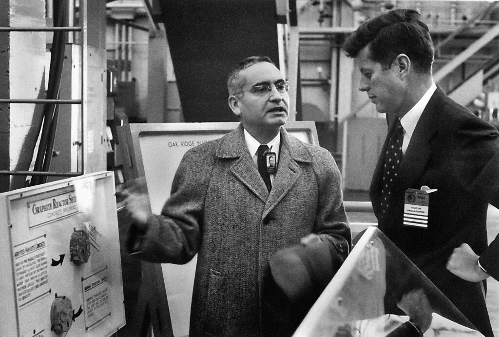
In the end, it was President John F. Kennedy who reacted most enthusiastically, speaking on September 25, 1963:
“We are now examining in the United States today the mixed economic-technical question of whether the very large scale nuclear reactors can produce unexpected savings in the simultaneous desalination of water and the generation of electricity? We will have before this decade is out or sooner a tremendous nuclear reactor which makes electricity and at the same time gets fresh water from salt water at a competitive price. What a difference this can make to the United States. And indeed, not only the US but all around the globe where there are so many deserts on the ocean’s edge.”
The idea reached later the ear of AEC’s patron Lewis Strauss.
“The time was 1967, just after the Six-Day War, and the Middle East was much on our minds. The ultimate problem of the Middle East is water – a point that is now perhaps more fully recognized than it was in 1967. Why not build dual-purpose nuclear and electric desalting plants in Egypt, Israel and Jordan – literally make the deserts bloom– and thereby create a major new possibility for a settlement in the Israeli-Arab conflict?”
Lewis conveyed this idea to Eisenhower and Ike published in Life magazine an outline of what became known as the Eisenhower plan, based “on what Lewis and I had discussed”, writes Weinberg.
ORNL then sent a team to visit Egypt, Israel and Lebanon where they were warmly received. The visit brought to Tennessee Israeli and Egyptian engineers who were integrated in the Middle East Study Project,
“which studied what we called ‘nuclear-powered agro-industrial complexes,’ something already studied in 1966. Such complexes would use nuclear reactors to produce electricity and water; the electricity would be used for both domestic and industrial purposes; the water would be used to grow high-value crops.”
“The Middle East project adapted these earlier results to the Israeli-Egyptian situation. A multi-volume report of the Middle East project was issued in which we examined the feasibility of nuclear agro-industrial complexes to be built as national projects in the El-Hamman area near Alexandria in Egypt, and the western Negev area of Israel, and as an international project near the Gaza strip. The implication was that the complexes would be subsidized by the United States.”
“I met with then-ambassador Yitzhak Rabin of Israel for about an hour at the Knoxville airport to tell him about our results. Rabin, who became prime minister of Israel, was skeptical – both as to the political feasibility of a project conducted jointly by Israelis and Arabs, and the economic feasibility of such a huge undertaking. But most of all he suggested that we had extraordinary chutzpah, sitting in Tennessee and figuring out a scheme to resolve a bitter ethnic dispute some six thousand miles away! Of course Rabin had a point on both scores; but I couldn’t refrain from saying, ‘But Mr. Ambassador, is our drawing up plans in Tennessee for agro-industrial complexes for the Middle East is any sillier than Theodore Herzl’s drawing up plans for Israel, in a Vienna café in 1896?’”
Weinberg, clearly unaware of the Dulles brothers‘ operations sabotaging anything good Ike wanted to accomplish regretted: “The Eisenhower-Baker plan was never implemented: the political will needed to support building large reactors in the strife-riven Middle East was lacking…”
The LaRouche Oasis plan, like any other proposal along the same lines, has so far been blocked by the Israeli, American and British sides, and we know only too well what happened to Yitzhak Rabin, assassinated after signing the Oslo Accords, to Shimon Peres, ousted, and to a demonized Yasser Arafat. In addition, LaRouche has been slandered and called an anti-Semite.
On April 13, 2034, LaRouche’s Oasis Plan and its relevance for today was discussed and debated during an international zoom conference and endorsed by several high level ambassadors and diplomats from Palestine, South Africa, Russia and Guyana.
Similar events are being prepared to continue the discussion and turn this dream into reality.
Afghanistan: Qosh Tepa canal and prospects of Aral Sea basin water management

Presentation of Karel Vereycken at the second panel discussion of the « Water for Peace » seminar organized by the Schiller Institute on January 9, 2024 in Paris.
Let’s start with current events. In August 2021, faced with the Taliban takeover, the United States hastily withdrew from Afghanistan, one of the world’s poorest countries, whose population has doubled in 20 years to 39.5 million.
While the UN acknowledged that the country was facing « the worst humanitarian crisis » in the post-war era, overnight all international aid, which represented more than half of the Afghan budget, was suspended. At the same time, $9.5 billion of the country’s central bank assets, held in accounts at the US Federal Reserve and a number of European banks, were frozen.
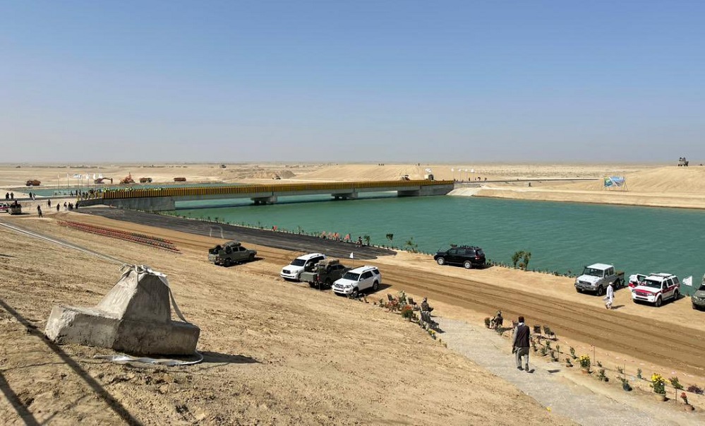
Qosh Tepa canal
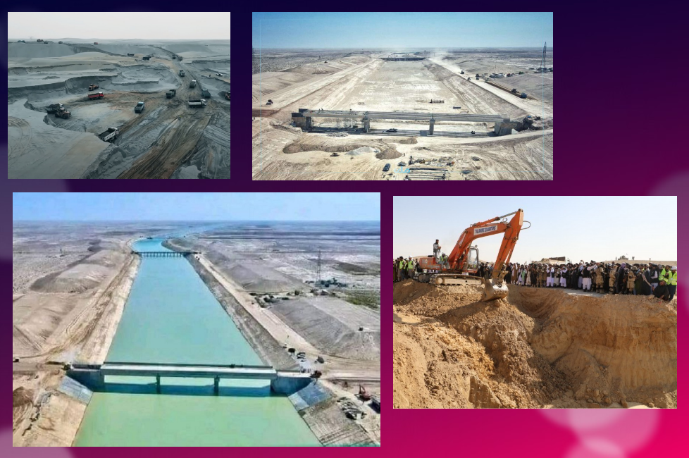
Despite these dramatic conditions, the Afghan government, via its state construction group, the National Development Company (NDC), committed $684 million to a major river infrastructure project, the Qosh Tepa Canal, which had been suspended since the Soviet invasion.
In less than a week, over 7,000 drivers flocked from the four corners of the country to work day and night on the first section of the canal, the first phase of which was completed in record time.
Politically, the canal project is a clear expression of the re-birth of an inclusive Afghanistan, as the region is mainly inhabited by Turkmen and Tajik populations, whereas the government is exclusively in the hands of the Pashtuns. The latter represent 57% rather than 37% of the country.
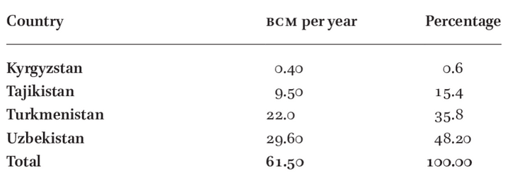
According to the FAO, 62.5% of the Abu Darya’s water comes from Tajikistan, 27.5% from Afghanistan (22 million m3), 6.3% from Uzbekistan, 1.9% from Kyrgyzstan and 1.9% from Turkmenistan.

The river irrigates 469,000 ha of farmland in Tajikistan, 2,000,000 ha in Turkmenistan and 2,321,000 ha in Uzbekistan.
So it’s only natural that Afghanistan should harness some of the river’s waters (10 million m³ out of a total of 61.5 to 80 million m³ per year) to irrigate its territory and boost its ailing agricultural production
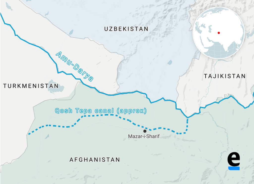
By harnessing part of the waters of the Amu Daria river, the new 285 km-long canal will eventually irrigate 550,000 ha of arid land in ancient Bactria to the north, the « Land of a 1000 Cities » and« The Land of Oases » whose incomparable fertility was already praised by the 1st-century Greek historian Strabo.
In October 2023, the first 108 km section was impounded.
Agricultural production has been kick-started to consolidate the riverbanks, and 250,000 jobs are being created.
While opium poppy cultivation has been virtually eradicated in the Helmhand, the aim is to double the country’s wheat production and to become a grain net exporter.
Today, whatever one may think of the regime, the Afghans, who for 40 years have been self-destructing in proxy wars in the service of the Soviets and Americans, have decided to take their destiny into their own hands. Putting an end to the systemic corruption that has enriched an international oligarchy, they are determined to build their country and give their children a future, notably by making water available for irrigation, for health and for the inhabitants.
How did the world react?
On November 7, in The Guardian, Daanish Mustafa, a professor of « critical geography », explains that Pakistan must rid itself of the colonial spirit of water.
In his view, the floods that hit Pakistan in 2010 and 2022 demonstrate that « colonial » river and canal development is a recipe for disaster. It’s time, he concludes, to « decolonize » our imaginations on the subject of water by abandoning all our vanitous desires to manage water.
On November 9, the Khaama Press News agency reported:

« Tensions have risen between the de facto authorities of Afghanistan and Pakistan due to the ongoing deportation of Afghan migrants. Most recently, Pakistan has called for a halt to the Qush Tepa project. Abdul Haq Hamad, former head of media publications supervision, said in a televised debate that the Pakistani authorities had made it explicitly known at an official meeting with Taliban administration leaders that they must ‘stop operations on the Qush Tepa channel’.
« According to him, the Pakistani authorities are not satisfied with the completion of the Qosh Tepa Canal, as Afghanistan gains autonomy through this canal in managing its waters. »
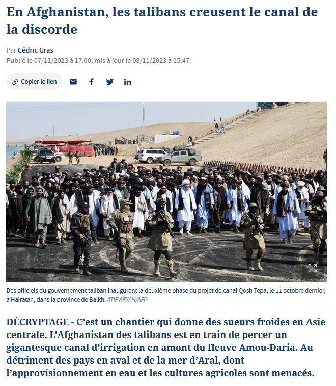
Two days earlier, on November 7, Cédric Gras, Le Figaro‘s correspondent in Tashkent, published an article entitled:
« En Afghanistan, les Talibans creusent le canal de la discorde » (« In Afghanistan, the Taliban are digging the canal of discord »):
« The Afghanistan of the Taliban is in the process of digging a gigantic irrigation canal upstream from the Amou-Daria river. To the detriment of downstream countries and the Aral Sea, whose water supply and agricultural crops are threatened ».
Obviously, the aim is to create scare. But if the accusation is hasty, it touches on a fundamental issue that deserves explanation.
Endoreic basin
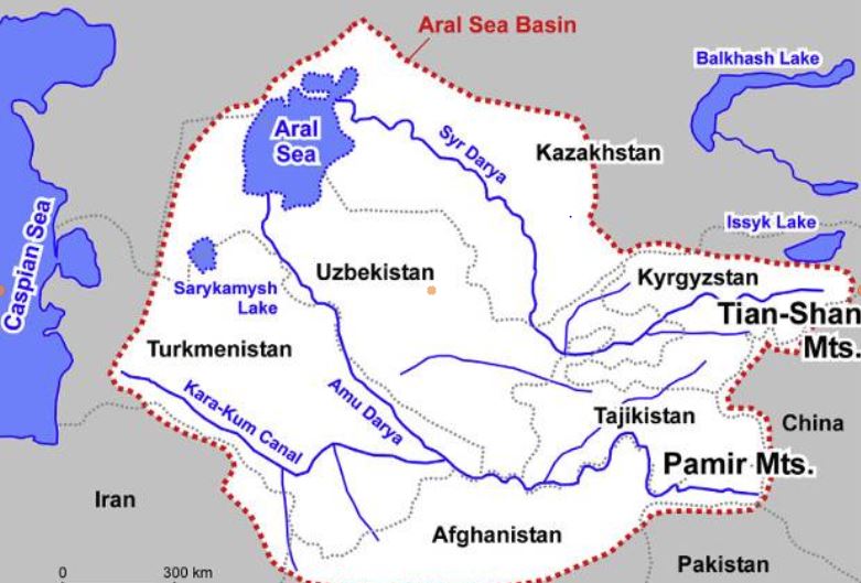
The Amu Daria, the 2539 km long river that the Greeks called the Oxus, and its brother, the 2212 km long Syr Daria, feed, or rather used to feed, the Aral Sea, which straddles the border between Uzbekistan and Kazakhstan. The water of both rivers were increasingly redirected by soviet experts to irrigate mainly cotton cultivation causing the Aral Sea to disappear.
I won’t go into detail here on the history of the ecological disaster that everyone has heard about but I am ready to answer your questions on that later;
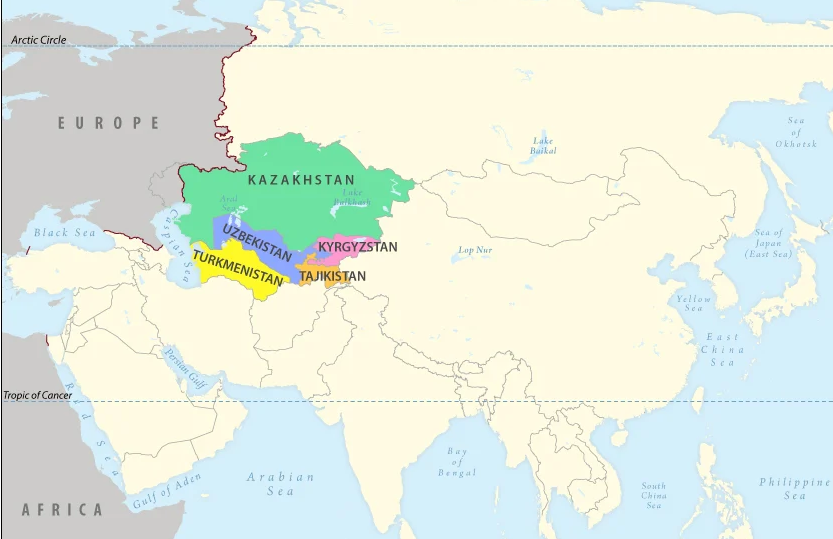
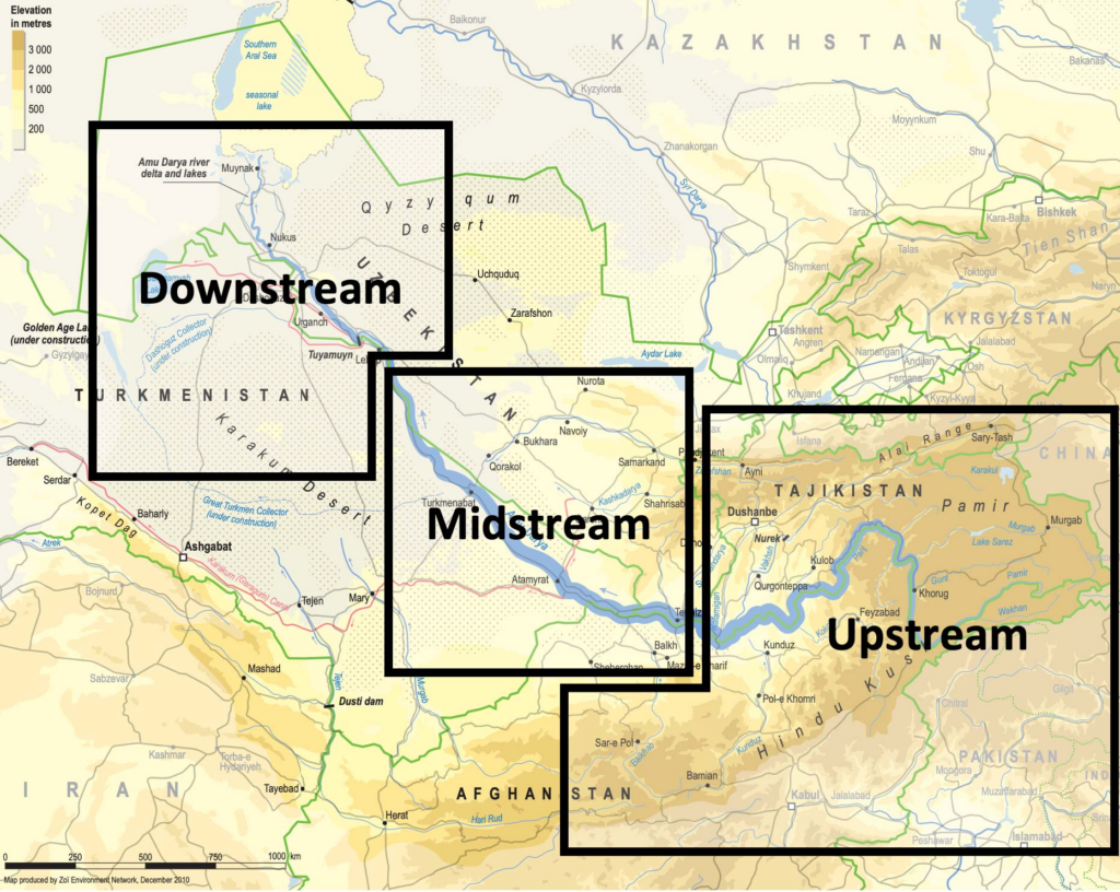
The « Aral Sea Basin » essentially covers five Central Asian « stan » countries. To the North, these are Kazakhstan, followed by Kyrgyzstan, Tajikistan, Uzbekistan and Turkmenistan.
In fact, Afghanistan, whose border with the latter three countries is formed by sections of the Amu Darya, is geologically and geographically part of the « Aral Sea Basin ».
This is a so-called « endoreic basin ». (endo = inside; rhein = carried).
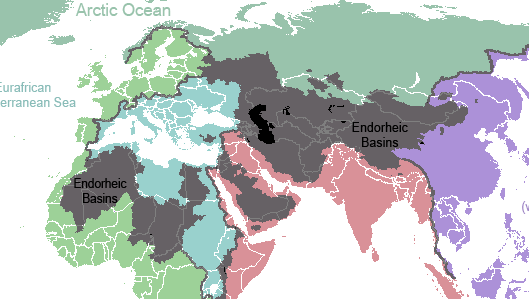

In Europe, we see falling rain and snowmelt flowing into rivers that discharge it into the sea. Not so in Central Asia. Rainwater, or water from melting snow, flows down mountain ranges. They eventually form rivers that either disappear under the sands, or form « inland seas » having no connection whatever to a larger sea and no outlet to the oceans. 18% of the world’s emerged surface is endoreic.
Among the best-known endoreic basins are the Dead Sea in Israel and Lake Chad in Africa.
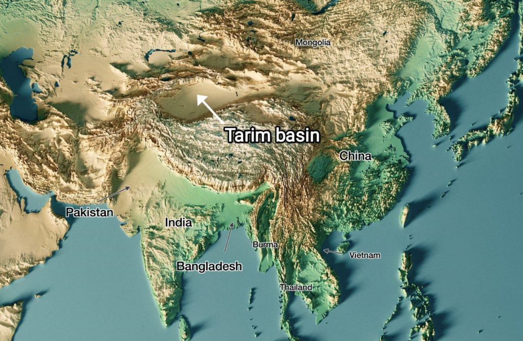
In Asia, there are plenty of them. Just think of the Tarim Basin, the world’s largest endoreic river basin in Qinjiang, covering over 400,000 km². Then there’s the vast Caspian Sea, the Balkhach and Alakoll lakes in Kazakhstan, the Yssyk Kul in Kyrgyzstan and, as we’ve just said, the Aral Sea.
The very nature of an endoreic basin strongly reinforces the fear that water is a scarce limited source. That realty can either bolster the conviction that problems cannot but be solved true cooperation and discussion, or push countries to go to war one against the other. Democraphic growth, economic progress and climate/meteorogical chaos can worsen that perception and make water issues appear as a « time-bomb ».
The early Soviet planners started with a strict quota system laid down in 1987 by Protocol 566 of the Scientific and Technical Council of the Soviet Ministry of Water Resources. The system fixed quotas for all countries, both in percentage and in BCM (Billions of Cubic Meters).
That simple quota system looks 100 % functional on paper. However, nations are not abstractions.
First, this system created quite rigid procedures and even would forbid some upstream countries to invest in their own agriculture since they had to deliver the water to their neighbors.
Second, conflict arose about dissymetric seasonal use of the water. The use of the water was completely different between « Upstream countries » such as Kyrgyzstan and Tajikistan and « Downstream countries » such as Uzbekistan and Turkmenistan.
Upstream countries could accept releasing their water resources in autumn and winter since the release of the water provides them up to 90 % of their electricity via hydrodams.
Downstream countries however don’t need the water at that time but in spring and summer when their farmland needs to be irrigated.
However, in Central Asia, their seems to exist some sort of « geological justice » since downstream countries lacking water (Kazakhstan, Uzbekhistan and Turkmenistan) have vast hydrocarbon energy reserves such as coal, oil and gaz.
Therefore, not always stupid, Soviet planners, which realized that a simple quota system was insufficient to prevent conflict, created a compensation mechanism. Downstream nations, in exchange for water, would supply parts of their oil and gas to upstream nations to compensate the loss of potential energy that water represents.
However imperfect that mechanism, for want of a better one, it remained in place after the collapse of the Soviet Union in 1991.
It can be said that by appealing to an external factor of a given problem, in this case to bring energy in the equation to solve the water problem, soviet planners conceived in a rudimentary form what became known as the « Water, Energy, Food Nexus ». One cannot deal with theses factors as separate factors. They have to be conceived as part of a single, dynamic Monad.
Today, we should avoid the geopolitical trap. If we consider the water resources to be shared between the states of Central Asia and Afghanistan to be « limited », or even « declining » due to meteorological phenomena such as El Nino, we might hastily and geopolitically conclude that, with the construction of the Qosh Tepa canal, which will tap water from the Amu Daria, the « water time bomb » cannot but explode.
Solutions
So we need to be creative. We don’t have all the solutions but some ideas about where to find them:
- In Central Asia, especially in Turkmenistan but also Uzbekistan, huge quantities of water from the Abu Daria water basin are wasted. In 2021, Chinese researchers, looking at Central Asia’s potential in terms of food production, estimated that with improvements in irrigation, better seeds and other « agricultural technology », 56 % of the water can be saved farming the same crops, meaning that today, about half of the water is simply wasted.
- The lack of investment into new water infrastructure and maintenance cannot but lead to the kind of disasters the world has seen in Libya or Pakistan where, predictably, systems collapsed for lack of mere maintenance;
- Uncontrolled and controlled flooding are very primitive and inefficient forms of irrigation and should be outphased and replaced by modern irrigation techniques;
- Therefore, a water emergency should be declared and a vast international effort should assist all the countries of the Abu Daria basin, including Afghanistan, to modernize and improve the efficiency of their water infrastructure, be it lakes, canals, rivers and irrigation systems.
- Such and effort can best organized within the framework of the « One Belt, One Road » initiative and the Shanghai Cooperation Organization. BRICS countries such as China, Russia and India could help Afghanistan with data from their satellites and space programs.
- By improving the efficiency of water use, notably through targeted irrigation using « drip irrigation » as seen in the case of the Tarim basin in Xinjiang, it is possible to reduce the total amount of water used to obtain an even higher yield of agriculture production, while considerably increasing the availability of the water to be shared among neighbors. The know how and experience of African, South American, Israeli and Chinese agronomists, specialized in food production in arid countries, can play a key role.
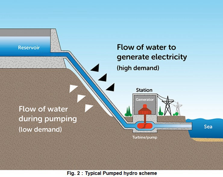
- In the near future, Pumped Hydro Energy Storage (PHES), which means storing water in high altitude reservoirs for a later use, can massively increase the independance and autonomy of countries such as Afghanistan and others. Having sufficient water at hand at any time means also having the water security required to operate mining activities and handle thermal and nuclear electricity production units. PHES infrastructure would be greatly efficient on both sides of the Abu Daria and jointly operated among friendly nations.
Over the past 1,200 years, nations bordering waterways have concluded 3,600 treaties on the sharing of river usufructs, whether for fishing, river transport or the sharing of water for domestic, agricultural and industrial uses.
Afghanistan’s Qosh Tepa canal project is a laudable and legitimate initiative. But it is true that by breaking the status quo, it obliges a new dialogue among nations allowing each and all of them to rise to a higher level, a willing to live together increasingly the opposite to the dominant paradigm in the Anglosphere and its european followers.
It’s up to all of us to make sure it works out fine.
Grands travaux : l’exemple inspirant du « Plan Freycinet »

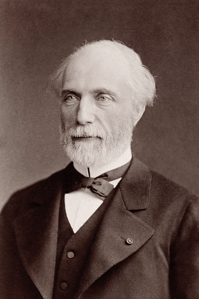
En 1878, le ministre des travaux publics, l’ingénieur et polytechnicien Charles de Freycinet (1828-1923), proche de Léon Gambetta, lance un ambitieux programme de travaux publics.
Il comprenait principalement le parachèvement des voies ferrées, mais aussi la construction de canaux et d’installations portuaires, l’ensemble conçu comme un tout intégré où chaque partie apporte sa contribution.
L’analyse de Charles de Freycinet sur les buts de la science économique est limpide et se résume en une phrase : « Le progrès économique, c’est la plus grande satisfaction pour le moindre effort. »
Si l’objectif phare est de donner accès au chemin de fer à tous les Français, il s’agit de favoriser le développement économique du pays par le désenclavement des régions reculées.
Les promoteurs du plan veulent également aboutir à un contrôle plus strict de l’État voire au rachat des compagnies de chemins de fer.
L’analyse de Freycinet sur les buts de la science économique n’est pas sans rappeler la pensée du philosophe et scientifique allemand Leibniz :
« La science économique étant l’étude des causes qui concourent à la satisfaction des besoins matériels de l’homme, le progrès économique peut se résumer d’un mot: c’est la plus grande satisfaction pour le moindre effort. En d’autres termes, il consiste dans l’accroissement continu de la production pour une somme de travail déterminée.
Ainsi, rendre son effort de plus en plus efficace, de plus en plus fécond, tel est le véritable problème pour l’économie. Telle est la voie qui le conduit à l’affranchissement dont nous parlions et qui permet d’entrevoir cette vie idéale, de xxx et de lumières, qui est à la fois la plus noble des jouissances et l’accomplissement du plus impérieux des devoirs.
« On remarquera en quoi le progrès économique, tel que nous le comprenons, diffère de l’idée qui généralement a cours. On considère assez souvent comme étant un progrès une société dans laquelle la richesse augmente. Pour nous, ce signe extérieur ne suffit pas… ».
(Page 1 de son projet de livre Le Progrès économique de 1887, manuscrit jamais publié)
Pour sa mise en œuvre, le « plan Freycinet » est inscrit dans la loi de Finances et une première loi est votée le 18 mai 1878.
Ensuite, il fait l’objet de trois lois promulguées par Jules Grévy, président de la République, à quelques jours d’intervalle:
1. Nouvelles lignes ferroviaires nationales et secondaires
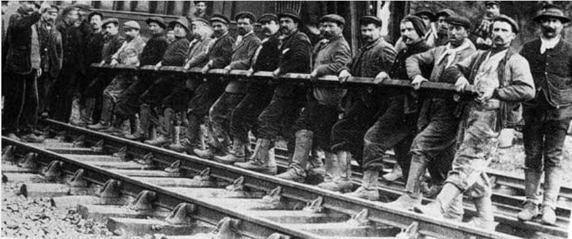
La première concerne la construction de 8700 kilomètres de nouvelles voies ferroviaires soit 154 lignes dites d’intérêt général (avec un écartement des voies d’1m43) afin de desservir toutes les sous-préfectures du pays.
Leur construction est assurée, soit par les grandes compagnies privées, le coût étant le plus souvent pris en charge par l’État, soit par l’État lui-même. Freycinet est ainsi à l’origine de la compagnie de l’État (loi du 18 mai 1878).
Dans le même temps il s’agit de désenclaver tous les chefs lieux de cantons par des réseaux secondaires (lignes dites « d’intérêt local » avec un écartement des voies d’1 m) construites principalement à l’initiative des conseils généraux.
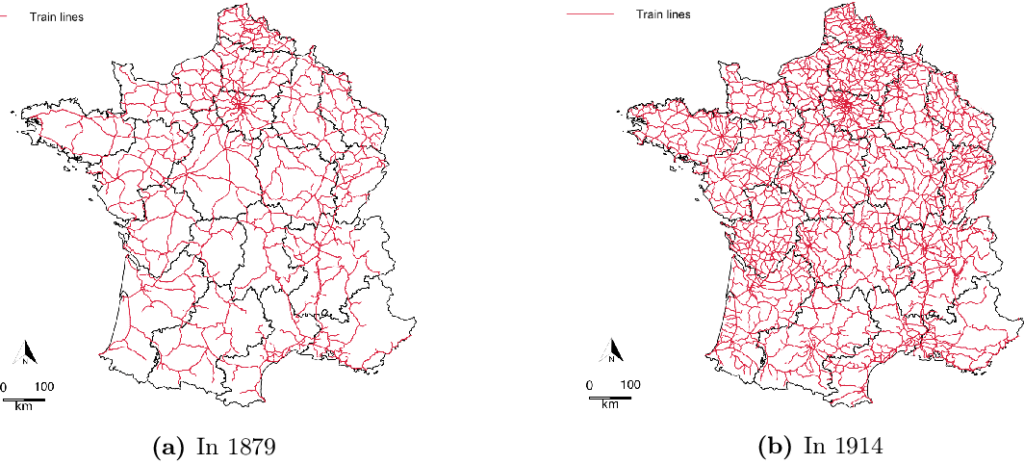
La longueur des ces réseaux départementaux passera de 2187 kilomètres en 1880 à 17 653 km en 1913.
2. L’aménagement du réseau fluvial
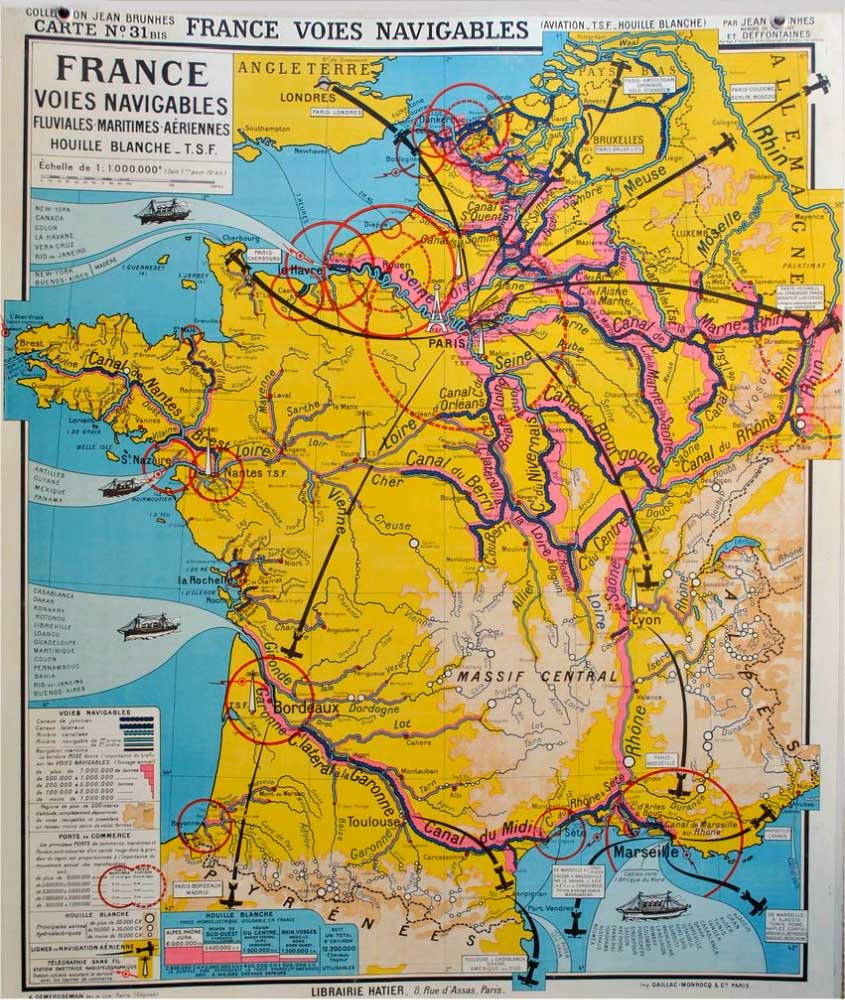
Dans le domaine de la navigation fluviale le plan Freycinet ambitionne la création d’un réseau national unifié et cohérent de voies navigables, par l’amélioration de 14 600 km de voies existantes et par la mise en service de 1900 km de canaux supplémentaires.
Le plan Freycinet porte les dimensions des écluses à 39 m de long pour 5,20 m de large, afin qu’elles soient franchissables par des péniches de 300 à 350 tonnes.
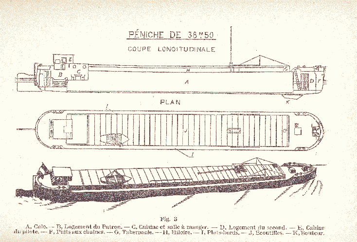
En conséquence, les bateaux au gabarit Freycinet ne doivent pas dépasser 38,5 m sur 5,05 m.
Le « gabarit Freycinet » correspond aujourd’hui au gabarit européen de classe I.
En France, 5800 km de voies fluviales ont conservés cette taille et en 2011, 23 % du trafic fluvial y transite.
3. La modernisation des ports
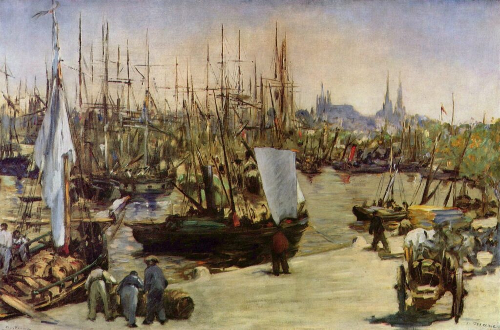
Au niveau portuaire, Freycinet déplore que :
« Les crédits accordés pour ces travaux [la modernisation des ports] n’aient jamais été à la hauteur des besoins et tandis que les Anglais, les Hollandais, les Belges dépensaient sous nos yeux des centaines de millions pour créer ou transformer leurs magnifiques établissements de Liverpool, de Glasgow, d’Amsterdam ou d’Anvers, nous restions toujours fort loin en arrière. »
L’originalité du plan Freycinet, au niveau portuaire, recouvre trois aspects :
–le souci de l’interconnexion,
–l’étendue et
–le mode de financement.
La modernisation des ports, affirme-t-il :
« est imposée par la transformation du matériel naval, par le développement incessant des chemins de fer et des autres voies de communication, par les besoins de célérité et de régularité qui s’introduisent chaque jour davantage dans les habitudes du commerce et de l’industrie. »
Freycinet, qui avait bien conscience que la bataille pour le maritime se gagne sur terre ferme. Un port sans hinterland capable d’accueillir les flux de marchandises est comme un cœur déconnecté d’artères en mesure de faire circuler le sang.
Freycinet mettra donc l’accent sur l’amélioration de l’intermodalité, ce qui signifie l’extension des quais, la multiplication des bassins, notamment à flot, l’approfondissement des chenaux, afin que « l’installation générale soit appropriée à la fois aux deux modes de transport qui viennent s’y rencontrer ».
Alors que l’État financera les superstructures, les infrastructures, l’outillage sera à la charge des chambres de commerce ou des particuliers par voie de concession. 116 ports sur 188 sont ainsi modernisés.
–La longueur utile des quais passe de 140 km en 1879 à 205 km en 1900, une augmentation de 46 % ;
–le nombre de ports présentant plus de 7 mètres de profondeur s’est élevé de 9 en 1878 à 15 en 1900 ;
–le tonnage de jauge de navires entrés et sortis a progressé de 64 % entre 1878 et 1898 ;
–aux mêmes dates, le poids des marchandises importées ou exportées a augmenté de 75 %, passant de 17 à 30 millions de tonnes.
L’abaissement du prix du fret, l’accroissement de la rapidité et de la régularité des transports, le perfectionnement des moyens de manutention sont autant de progrès à enregistrer.
Un plan décennal
Dans son chiffrage initial, largement dépassé au final, le plan prévoyait de consacrer environ 3 milliards de francs aux lignes de chemin de fer, 1 milliard aux canaux et 500 millions aux ports. Le tout était financé par un crédit d’État à 3 %, remboursable en 75 annuités.
Si à l’origine, le « plan Freycinet » aurait du être réalisé en dix ans, la faillite retentissante de la banque l’Union générale en 1882 (cadre du roman L’Argent de Zola) et la crise économique qu’elle engendrera, retarderont sa mise en œuvre.
La crise du crédit public brise l’élan et entraîne à moyen terme le ralentissement considérable du rythme des réalisations. Cet arrêt brutal aura deux conséquences.
D’une part, l’allongement des délais de construction provoque une élévation de leurs coûts, et de l’autre, l’abandon prématuré du système de financement imaginé par la loi du 11 juin 1878.
Ainsi, ce n’est qu’en 1914, c’est-à-dire après 36 ans, que l’ensemble du plan arrivera, à quelques détails près, à son stade de réalisation.
Entre-temps, cette mobilisation des forces productives, par effet d’entrainement, à fait naître le savoir-faire permettant la réalisation de la tour Eiffel ou les écluses du canal de Suez et celui de Panama.
Faute de crédit productif public et de volonté politique réelle, à part quelques miracles accomplis à l’époque De Gaulle/Pompidou, la France n’a jamais connue une initiative de cette ampleur visant à susciter un « choc de productivité » par l’investissement en infrastructures. Quel candidat aura aujourd’hui le courage et la compétence pour défendre un « Nouveau plan Freycinet » ?
Relance française
Le 1er octobre 2020, dans sa chronique dans Le Monde, Pierre-Cyrille Hautcoeur, professeur à PSE, directeur d’études EHESS, confirme la réussite retentissante du Plan Freycinet.
Extrait:
« Que ce soit sous l’effet direct du plan Freycinet ou d’un regain plus large d’optimisme, le PNB croît de 20 % de 1879 à 1882, l’investissement de près de 40 %, indiquent Maurice Lévy-Leboyer et François Bourguignon dans La Croissance française au XIXe siècle (Economica, 1985).
« Cette reprise rapide s’accompagne d’une flambée d’opérations financières, notamment autour du grand emprunt d’Etat lancé en 1881 pour financer le plan. Elle est stoppée net par le krach de 1882, auquel une partie des banques nouvellement créées ne résiste pas. Si le marasme reprend, le plan Freycinet n’en est pas moins poursuivi, et quasi achevé avant 1914.«
Gain de population
« Mal aimé par certains, qui y voient – avec un brin d’anachronisme – l’origine étatique du développement excessif d’une technologie révolue et peu profitable, ainsi qu’une hausse irresponsable de la dette publique (les 6 milliards du plan représentent 30 % du PNB de 1879), le plan Freycinet n’empêche pourtant pas l’industrie automobile française d’être l’une des plus innovatrices au monde, ni la croissance française d’être particulièrement élevée de 1895 à 1914.
« Il a, en outre, atteint nombre de ses objectifs : le renforcement durable du BTP et de la métallurgie, et le développement, désormais piloté par l’Etat, d’un système national de chemins de fer qui contribue à l’intégration économique et sociale du territoire. Les 964 communes – notamment toutes les sous-préfectures et beaucoup de chefs-lieux – connectées au réseau grâce au plan Freycinet gagnent en population par rapport aux autres villes dans les décennies qui suivent ; les départements les plus concernés y gagnent aussi en revenu relatif. Ce désenclavement progressif des campagnes traduit dans les faits, parallèlement à la diffusion des écoles et bureaux de poste, la promesse d’égalité de la République, et lui rallie durablement les populations. »
Persian Qanâts and the Civilization of Hidden Waters

By Karel Vereycken, July 2021.

By Karel Vereycken, July 2021.
At a time when old diseases make their return and new ones emerge worldwide, the tragic vulnerability of much of humanity poses an immense challenge.
One wonders whether to laugh or cry when international authorities trumpet without further clarification that to stop the Covid-19 pandemic, “all you have to do” is “wash your hands with soap and water”!
They forget one small detail: 3 billion people do not have facilities to wash their hands at home and 1.4 billion have no access to either water or soap!
Yet, since the dawn of time, mankind has demonstrated its capacity to mobilize its creative genius to make water available in the most remote places.
Here is a short presentation of a marvel of such human genius, the “qanâts”, an underground water conveyance system dating from the Iron Age. Probably of Egyptian origin, it was deployed on a large scale in Persia from the beginning of the 1st millennium BC.

The qanât or underground aqueduct

Sometimes called “horizontal drilling”, the qanât is an underground aqueduct employed to draw water from a water table and convey it by simple gravitational effect to urban settlements and farmland. The word qanât is an old Semitic word, probably Accadian, derived from a root qanat (reed) from which come canna and canal.
This “drainage gallery”, cut into the rock or built by man, is certainly one of the earliest and most ingenious inventions for irrigation in arid and semi-arid regions. The technique offers a significant advantage: by conveying water through an underground conduit, contrary to open air canals, not a single drop of water is wasted by evaporation.
Oases’ are NOT natural phenomena. All known oases are man-made. It is the qanât technique that allows man, in a given geographic configuration, to create oases in the middle of the desert, when a water table is close enough to the ground level or at a site close to the bed of a river lost in the sands of the desert.
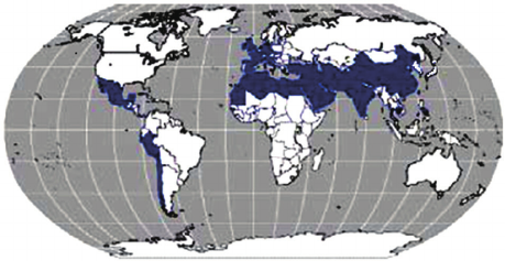
Copied and expanded by the Romans, the qanât technique was carried across the Atlantic to the New World by the Spaniards, where many such underground canals still function in Peru and Chile. In fact, there are even Persian qanâts in western Mexico.
While today this three thousand year old technique may not be appropriate everywhere to solve current water scarcity problems in arid and semi-arid regions, it has much to inspire us as a demonstration of human genius at its best, that is, capable of doing a lot with a little.
The oases of Egypt
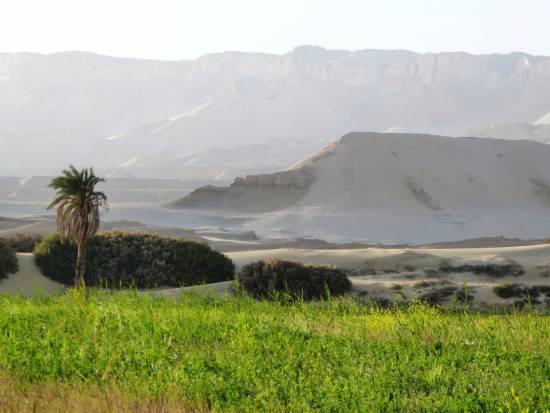
Today, 95% of the Egyptian population prospers on only 5% of its territory, mainly around the Nile delta. Hence, from the earliest days of Egyptian civilization, irrigation and water storage techniques for the Nile floods were developed in order to conserve this silty, nutrient-rich water for use throughout the year.
The river water was diverted and transported by canals to the fields by gravity. Since water from the Nile did not reach the oases, the Egyptians used the gushing water from the springs, which came from the large aquifer reserves of the western desert, and conveyed it to the fields by irrigation canals.
One of the fruits of this attempt to “conquer the desert” was a sustained habitation of the Dakhleh oasis throughout the Pharaonic period, explicable not only by a commercial interest on the part of the Egyptian state, but also by the new agricultural perspectives it offered.
Roman aqueducts
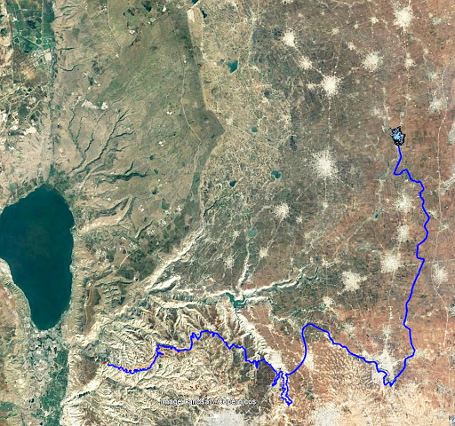
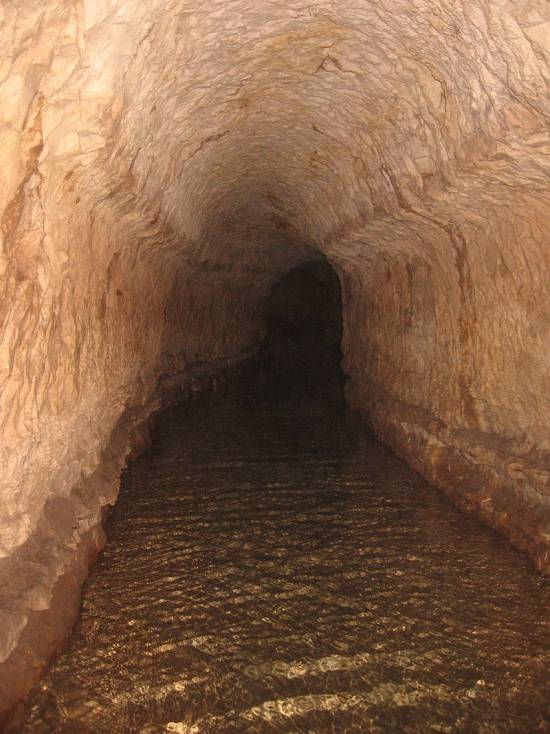
Closer to us in time, the Qanât Fir’aun (The Watercourse of the Pharaoh) also known as the aqueduct of Gadara, a city today in Jordan. As far as we know, this 170 km long structure, depending on the geography, combines several bridge-aqueducts (of the same type as the Gard aqueduct in France) and 106 km of underground canals using the Persian qanât technique. It is not only the longest but also the most sophisticated aqueduct of antiquity, and the fruit of a years of hydraulic engineering.
In reality, the Romans, hiring persian water experts, did nothing more than terminate in the 2nd century an ancient project designed to supply water to the “Decapolis”, a collaborative group of ten cities founded by Greek and Macedonian settlers under the Seleucid king Antiochos III (223 – 187 BC), one of the successors of Alexander the Great.
These ten cities were located on the eastern border of the Roman Empire (now in Syria, Jordan and Israel), united by language, culture and political status, each with a degree of autonomy and self-rule. Its capital, Gadara, was home to more than 50,000 people and known for its cosmopolitan atmosphere, its own university attracting scholars, writers, artists, philosophers and poets. But this rich city lacked something existential : an abundance of water.
The Gadara qanat made the difference. “In the capital alone, there were thousands of fountains, watering holes and baths. Wealthy senators cooled themselves in private pools and decorated their gardens with cooling caves. The result was a record daily consumption of more than 500 liters of water per capita,” explains Matthias Schulz, author of a report on the aqueduct in Spiegel Online.
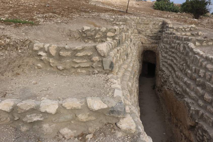
Persia
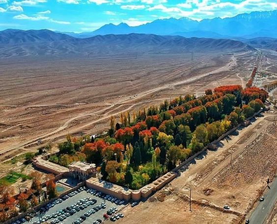
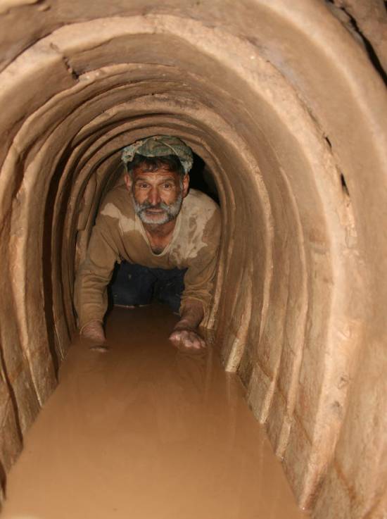
We all admire the roman aqueducts. But few of us are aware that the Romans only adapted the technique of the qanâts developed much earlier in Persia.
Indeed, it was under the Achaemenid Empire (around 559 – 330 BC.), that this technique spread slowly from Persia to the east and the west. Many qanâts can be found in North Africa (Morocco, Algeria, Libya), in the South East Asia (Iran, Oman, Iraq) and further east, in Central Asia, from Afghanistan to China (Xinjiang), via India.
The development of these “draining galleries” is attested in different regions of the world under various names: qanât and kareez in Iran, Syria and Egypt, kariz, kehriz in Pakistan and Afghanistan, aflaj in Oman, galeria in Spain, kahn in Balochistan, kanerjing in China, foggara in North Africa, khettara in Morocco, ngruttati in Sicily, bottini of Siena, etc.
Historically, the majority of the populations of Iran and other arid regions of Asia or North Africa depended on the water provided by the qanâts; their construction lifted entire areas to a higher “economic platform”, made deserts habitable and opened new land for agriculture. The map of demographic expansion followed the trail of the development of this new higher platform.
In his article « Du rythme naturel au rythme humain : vie et mort d’une technique traditionnelle, le qanât » (From natural rhythm to human rhythm: the life and death of a traditional technique, the qanât), Pierre Lombard, a researcher at the French CNRS, points out that this is not an artisanal and marginal process:
“Until a few years ago, the importance of the ancestral technique of qanât was sometimes ignored in Central Asia, Iran, Syria, and even in the countries of the Arabian Peninsula. For example, the Public Authority for Water Resources of the Sultanate of Oman estimated in 1982 that all the qanâts still in operation conveyed more than 70 % of the total water used in that country and irrigated nearly 55% of the cereal lands. Oman was still one of the few states in the Middle East to maintain and sometimes even develop its qanât network; this situation, apart from its longevity, does not appear to be exceptional. If one turns to the edges of the Iranian Plateau, one can note with Wulff (1968) the obvious discrepancy between the relative aridity of this area (between 100 and 250 mm of annual precipitation) and its non-negligible agricultural production, and explain it by one of the densest networks of qanâts in the Middle East. It can also be recalled that until the construction of the Karaj dam in the early 1960s, the two million inhabitants of Tehran at that time consumed exclusively the water brought from the Elbourz foothills by several dozen regularly maintained qanâts. Finally, we can mention the case of some major oases in the Near and Middle East (Kharga in Egypt, Layla in Saudi Arabia, Al Ain in the United Arab Emirates, etc.) or in Central Asia (Turfan, in Chinese Turkestan) that owe their vast development, if not their very existence, to this remarkable technique.”
On the website ArchéOrient, the French archaeologist Rémy Boucharlat, Director of Research Emeritus at the CNRS, an Iran expert, explains:
“Whatever the origin of the water, deep or not, the technique of construction of the gallery is the same. First, the issue is to identify the presence of water, either its going underground near a river, or the presence of a water table under a foothill, which requires the science and experience of specialists. A motherwell will be dug to reach the top of the water table, indicating at which depth the [horizontal] gallery should be drilled. It’s slope must be very small, less than 2‰, so that the flow of water is calm and regular, and conduct the water gradually to the surface area, according to a gradient much lower than the slope of the foothill.
“The gallery is then dug, not starting from the mother well because it would be immediately flooded, but from downstream, from the point of arrival. The conduct is first dug in an open trench, then covered, and finally gradually sinks into the ground in a tunnel. For the evacuation of soil and ventilation during excavation, as well as to identify the direction of the gallery, shafts are dug from the surface at regular intervals, between 5 and 30 m depending on the nature of the land ».
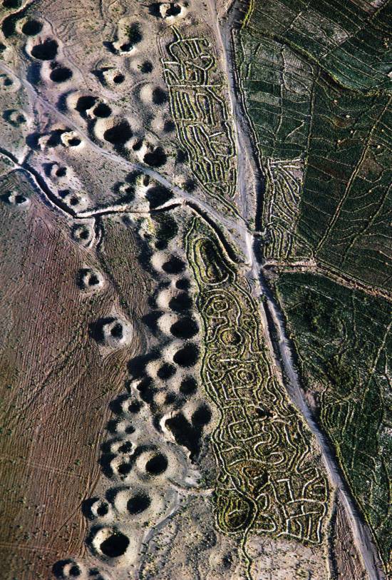
In April 1973, Lyndon LaRouche’s friend, the French-Iranian professor and historian Aly Mazahéri (1914-1991), published his translation from Arab into French of “The Civilization of Hidden Waters”, a treatise on the exploitation of underground waters composed in the year 1017 by the Persian hydrologist Mohammed Al-Karaji, who lived in Baghdad. (Translated in English in 2011)
After an introduction and general considerations on geography, natural phenomena, the water cycle, the study of terrain and the instruments of the hydrologist, Al-Karaji gives a highly precise technical outline of the construction and maintenance of qanâts, as well as legal considerations respecting their management and maintenance.
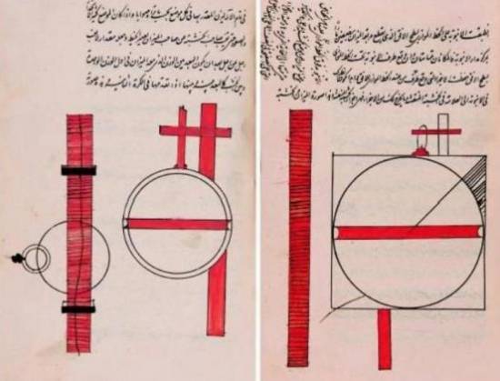
In his introduction to Al-Karji’s treatise, Professor Mazaheri emphasizes the role of the Iranian city of Merv (now in Turkmenistan). This ancient city, he says, was part of
“the long series of oases extending at the foot of the northern slope of the Iranian plateau, from the Caspian to the first foothills of the Pamirs. There, between the geological extension of the Caspian towards the East, there is a strip of arable land, more or less wide, but very fertile. Now, to exploit it, a lot of ingenuity is needed: where, for example in Merv, a big river, such as the Marghab, coming from the glaciers of the central East-Iranian massif, crosses the chain, it is necessary to establish dams, above the strip of arable land, without which, the ‘river’, divided into several dozens of arms, rushes under the sands. Elsewhere, and it is almost all along the northern slope of the chain, one can create artificial oases, by bringing the water by underground aqueducts.” (p. 44)
“The construction of dams and underground aqueducts are among the most interesting legacies of their (the ancient Persians) irrigation techniques (…) Long before Islam, the Persian hydrologists had built thousands of aqueducts, allowing the creation of hundreds of villages, dozens of cities previously unknown. And very often, even where there was a river, because of the insufficiency of this one, the hydronomists had brought to light many aqueducts allowing the extension of the culture and the development of the city. Naishabur was such a city. Under the Sassanids, and later under the Caliphs, an important network of aqueducts had been created there, so that the inhabitants could afford the luxury of owning a ‘’bathing room’ in the basement, at the level of the aqueduct serving the house.”

Let us recall that most Persian scholars, including the famous mathematician Al-Khwarizmi, not suffering from today’s hyper-specialization that tends to curb creative thinking, excelled in mathematics, geometry, astronomy and medicine as well as in hydrology.
Mazaheri confirms that this “civilization of underground waters” spread well beyond the Iranian borders:
“Already, under the [Umayyad] Caliph Hisham (723-42), Persian hydronomists built aqueducts between Damascus and Mecca (…) Later, Mecca suffering from lack of water, Zubayda, the wife of Hâroun Al-Rachîd, sent Persian hydronomists there who endowed the city with a large underground aqueduct. And each time the latter was silted up, a new team left Persia to restore the network: such repairs took place periodically under Al-Muqtadir (908-32), under Al-Qa’im (1031-1075), under Al-Naçir (1180-1226) and, at the beginning of the fourteenth century, under the Mongol prince Emir Tchoban. We would say the same of Medina and the stages on the pilgrimage route, between Baghdad and Mecca, wherever it was possible to do so, hydronomic works were undertaken and ‘underground aqueducts’ were created.
“Hydronomy is a highly demanding skill. To practice it, it is not enough to have mathematical knowledge: decadal calculus, algebra, trigonometry, etc., it is necessary to spend long hours in the galleries at the risk of dying by flooding, landslide or lack of air. It is necessary to have an ancestral instinct of ‘dowser’.”
The annual rainfall in Iran is 273 mm, which is less than one third of the world’s average annual precipitation.
The temporal and spatial distribution of precipitation is not uniform; about 75% occurs in a small area, mainly on the southern coast of the Caspian Sea, while the rest of the country does not receive sufficient rainfall. On the temporal scale, only 25% of the precipitation occurs during the plant growing season.
7,7 x the circonférence of the Earth

Still in use today in Iran, qanâts currently supply about 7.6 billion m3 of water, close to 15% of the country’s total water needs.
Considering that the average length of each qanât is 6 km in most parts of the country, the total length of the 30,000 qanât systems (potentially exploitable today) is about 310,800 km, which is about 7.7 times the circumference of the Earth or 6/7th of the Earth-Moon distance!
This shows the enormous amount of work and energy applied to build the qanâts. In fact, while more than 38,000 qanâts were in operation in Iran till 1966, its number dropped to 20,000 in 1998 and is currently estimated at 18,000. According to the Iranian daily Tehran Times, historically, over 120,000 qanat sites are documented.
Moreover, while in 1965, 30-50% of Iran’s total water needs were met by qanats, this figure has dropped to 15% in recent decades.
According to the Face Iran website:
“The water flow of qanâts is estimated between 500 and 750 cubic meters per second. As land aridity tends to vary according to the abundance of rains in each region, this quantity of water is used as a more or less important supplement. This makes it possible to use good land that would otherwise be barren. The importance of the impact on the desert can be summarized in one figure: about 3 million hectares. In seven centuries of hard work, the Dutch conquered 1.5 million hectares from the marshes or the sea. In three millennia, the Iranians have conquered twice as much on the desert.
Indeed, to each new qanât corresponded a new village, new lands. From where a new human group absorbed the demographic surplus. Little by little the Iranian landscape was constituted. At the end of the qanat, is the house of the chief, often with one floor. It is surrounded by the villagers’ houses, animal shelters, gardens and market gardens.
The distribution of land and the days of irrigation of the plots were regulated by the chief of the villages. Thus, a qanat imposed a solidarity between the inhabitants.”
If each qanât is “invented” and supervised by a mirab (dowser-hydrologist and discoverer), the realization of a qanât is a collective task that requires several months or years, even for medium-sized qanâts, not to mention works of record dimensions (a 300 m deep mother-well, a 70 km long gallery classified in 2016 as a World Heritage Site by UNESCO, in northeast Iran).
Each undertaking is carried out by a village or a group of villages. The absolute necessity of a collective investment in the infrastructure and its maintenance requires a higher notion of the common good, an indispensable complement to the notion of private property that rains and rivers do not take in account.
In the Maghreb, the management of water distributed by a khettara (the local name for qanâts) follows traditional distribution norms called “water rights”. Originally, the volume of water granted per user was proportional to the work contributed to build the khettara, translated into an irrigation time during which the beneficiary had access to the entire flow of the khettara for his fields. Even today, when the khettara has not dried up, this rule of the right to water persists and a share can be sold or bought. Because it is also necessary to take into account the surface area of the fields to be irrigated by each family.
The causes of the decline of the qanâts are numerous. Without endorsing the catastrophist theses of an anti-human ecology, it must be noted that in the face of the increasing urban population, the random construction of dams and the digging of deep wells equipped with electric pumps have disturbed and often depleted the aquifers and water tables.
A neoliberal ideology, falsely described as “modern”, also prefers the individualistic “manager” of a well to a collective management organized among neighbors and villages. A passive State authority has done the rest. In the absence of more thoughtful reflection on its future, the age-old system of qanâts is on the verge of extinction as a result.
In the meantime, the Iranian population has grown from 40 to over 82 million in 40 years. Instead of living off oil, the country is seeking to prosper through agriculture and industry. As a result, the need for water has increased substantially. To cope with rising demands, Iran is desalinating sea water at great cost. Its civilian nuclear program will be the key factor to provide water at a reasonable cost.
Beyond political and religious divisions, closer cooperation between all the countries in the region (Turkey, Syria, Iraq, Israel, Egypt, Jordan, etc.) with a perspective to improve, develop, manage and share water resources, will be beneficial to each and all.
Presented as an “Oasis Plan” and promoted for decades by the American thinker and economist Lyndon LaRouche, such a policy, translating word into action, is the only basis of a true peace policy.
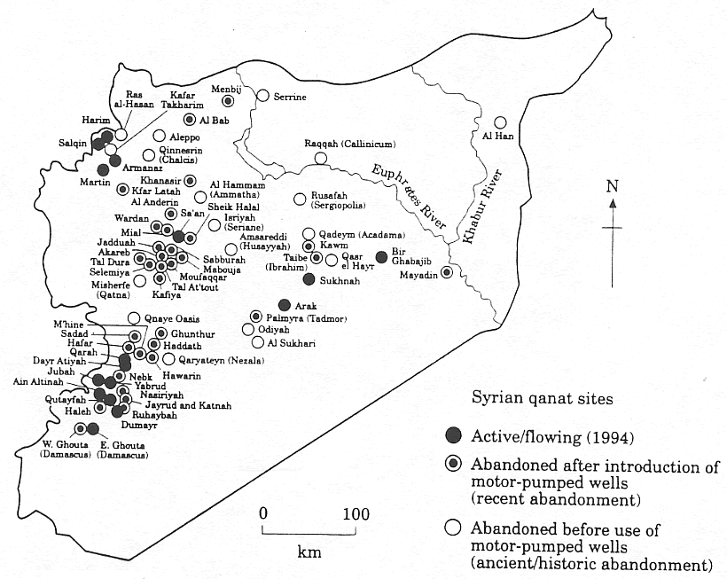
Bibliography :
- Remy Boucharlat, The falaj or qanât, a polycentric and multi-period invention, ArcheOrient – Le Blog, September 2015 ;
- Pierre Lombard, Du rythme naturel au rythme humain : vie et mort d’une technique traditionnelle, le qanat, Persée, 1991 ;
- Aly Mazaheri, La civilisation des eaux cachées, un traité de l’exploitation des eaux souterraines composé en 1017 par l’hydrologue perse Mohammed Al-Karaji, Persée, 1973 ;
- Hassan Ahmadi, Arash Malekian, Aliakbar Nazari Samani, The Qanat: A Living History in Iran, January 2010;
- Evelyne Ferron, Egyptians, Persians and Romans: the interests and stakes of the development of Egyptian oasis environments.
NOTE:
[1] The ten cities forming the Decapolis were: 1) Damascus in Syria, much further north, sometimes considered an honorary member of the Decapolis; 2) Philadelphia (Amman in Jordan); 3) Rhaphana (Capitolias, Bayt Ras in Jordan); 4) Scythopolis (Baysan or Beit-Shean in Israel), which is said to be its capital; It is the only city west of the Jordan River; 5) Gadara (Umm Qeis in Jordan); 6) Hippos (Hippus or Sussita, in Israel); 7) Dion (Tell al-Ashari in Syria); 8) Pella (Tabaqat Fahil in Jordan); 9) Gerasa (Jerash in Jordan) and 10) Canatha (Qanawat in Syria)


Krsta Paskovic: canal building from China to Serbia

In 2013, at the World Canal Conference in Toulouse, France, Karel Vereycken interviews Serbian, Chinese and Italian experts and historians on the important role of canals.