Étiquette : galerias
The science of Oases, from the Indus Valley to Persian qanats

Presentation of Karel Vereycken at the first panel discussion of the « Water for Peace » seminar organized by the Schiller Institute on January 9, 2024 in Paris.

While the dog was domesticated as early as 15,000 years BC, we associate the first human activities aimed at managing water with the Neolithic period, which began around 10,000 BC.
It is thought to be the moment at which mankind moved from a « tribal subsistence economy of hunter-gatherers » to agriculture and animal husbandry, giving rise to villages and cities, where pottery, weaving, metallurgy and the arts would start blooming.
Key to this, the domestication of animals. The goat was domesticated around 11,000 BC, the cow around 9,000 BC, the sheep around -8,000 BC, and finally the horse around 2,200 BC in the steppes of Ukraine.
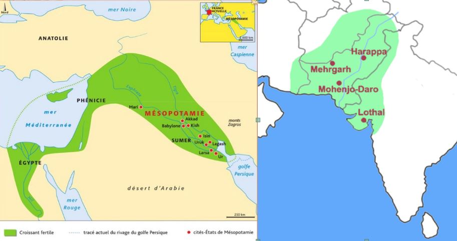
The oldest archaeological sites showing agricultural activities and irrigation techniques were discovered in the Indus Valley and the « Fertile Crescent ».
The site of Mehrgarh, in the Indus Valley, now Pakistan Balochistan, discovered in 1974 by François and Cathérine Jarrige, two French archaeologists, demonstrates important agricultural practices from 7000 BC onward.
Cotton, wheat and barley were grown, and beer was brewed. Cattle, sheep and goats were raised. But Mehrgarh was much more than that.
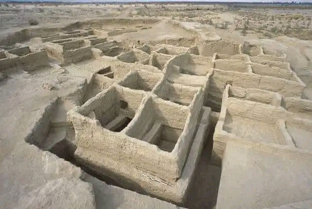
Contradicting the linear « developmental » schema, since we’re in the middle of the Neolithic, Mehrgarh is also home to the oldest pottery in South Asia and, above all, to the “Mehrgahr amulet”, the oldest bronze object casted with the « lost-wax » method.
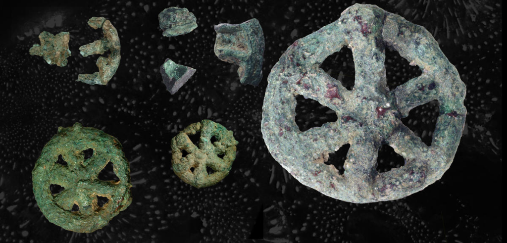
The first seals made of terracotta or bone and decorated with geometric motifs were found here.
On the technological side, tiny bow drills were used, possibly for dental treatment, as evidenced by the pierced teeth of some skeletons found on site.
At the same time, or shortly afterwards, around 6000 B.C., Mesopotamia, between the Tigris and Euphrates rivers, witnessed rapid urban development in terms of demographics, institutions, agriculture, techniques and trade.
A veritable « fertile crescent » emerged in the region stretching from Sumer to Egypt, passing through the whole of Mesopotamia and the Levant, i.e. Syria and the Jordan Valley.
Irrigation
Whether in the Indus Valley, Mesopotamia or Egypt, the earliest irrigation techniques are nothing but retaining as much water as possible when Mother Nature has the sweet kindness to offer it to mankind.
Rainwater was collected in cisterns and, as much as possible, when snowmelt or monsoon rains swell the rivers, the objective was to amplify and steer seasonal « flooding » by canals and trenches carrying the water as far away as possible to areas to be cultivated, while at the same time protecting crops.
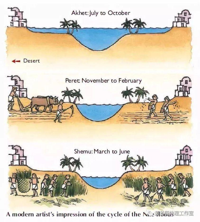
In Egypt, for example, where the Nile rises by around 8 meters, the water brings not only moisture but also silt to the soil near the river, providing crops with the nutrients they need to grow and thus maintain the soil’s fertility.
While the Egyptians complained about the harsh labor condition of their farmers, for the Greek historian Herodotus, this was the place in the world where work was least arduous. Of Egypt he says:
“Its soil is black and crumbly, made of silt and alluvium brought from Ethiopia by the river. Certainly, these people are today, of all the human race in Egypt as elsewhere, those who go to the least trouble to obtain their crops.
« They don’t bother to plough and weed. When the river has come of its own accord to water their fields and, its task done, has withdrawn, each man sows his land and lets the pigs loose: by trampling, the beasts sink the seeds into the earth, and the man has only to wait for the harvest.”
In Mehrgarh, where agriculture was born from 7000 BC, the work was indeed far more demanding.
However, the drainage system around the village and the rudimentary dams to control water-logging indicate that the inhabitants understood most of the basic principles involved. The cultivation of cotton, wheat and barley, as well as the domestication of animals, show that they were also familiar with canals and irrigation systems.
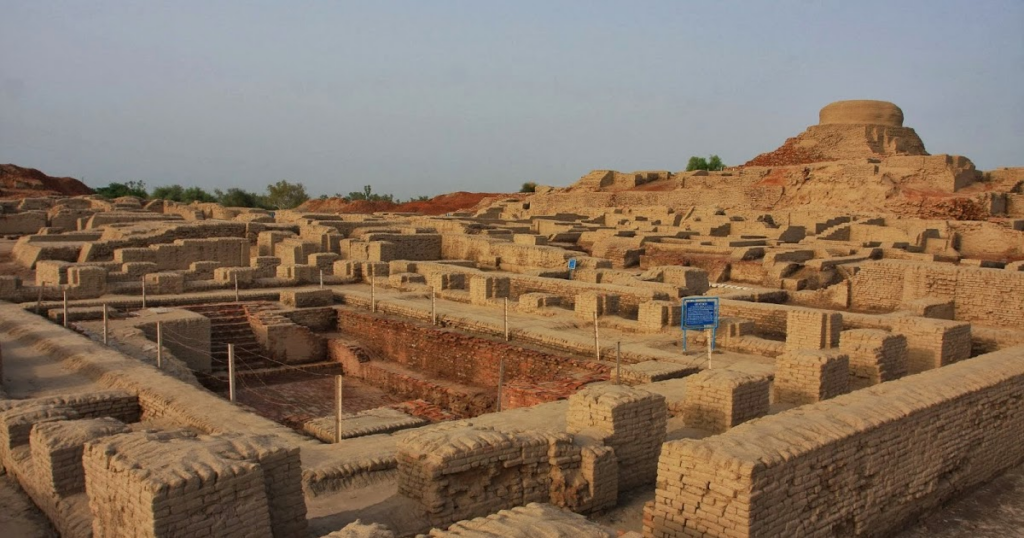
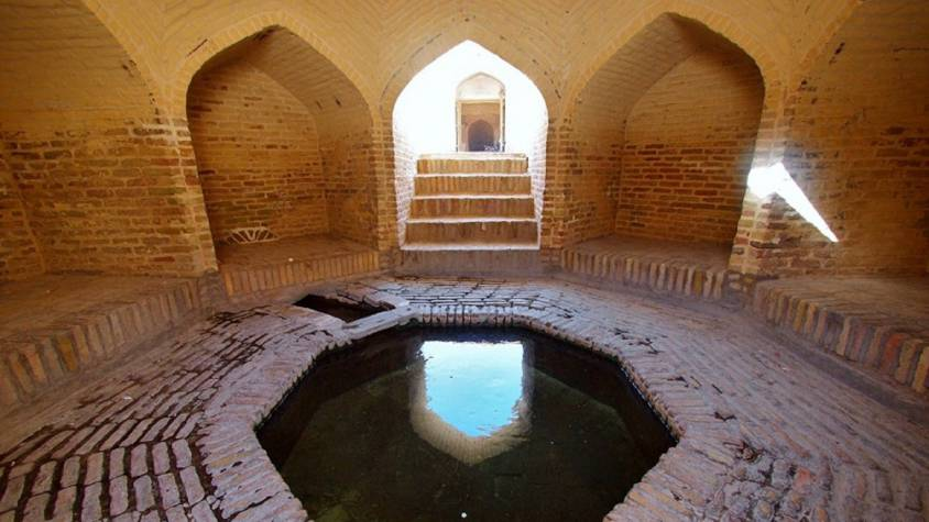
Constantly refined, this know-how enabled the civilization of the Indus Valley to create great cities that impress us by their modernity, notably Harappa and Mohenjo Daro, a city of 40,000 inhabitants with a public bath in its center, not a palace.
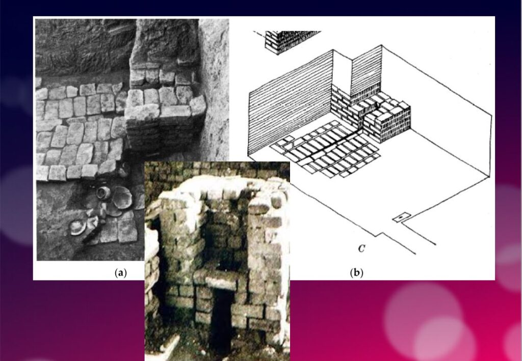
Pioneers of modern hygiene, these towns were equipped with small containers where residents could deposit their household waste.
Anticipating our « all-to-the-sewer » systems imagined in the early XVIth century by Leonardo da Vinci, for example in his plans for the new french capital of Romorantin, many towns had public water supplies as well as an ingenious sewage system.
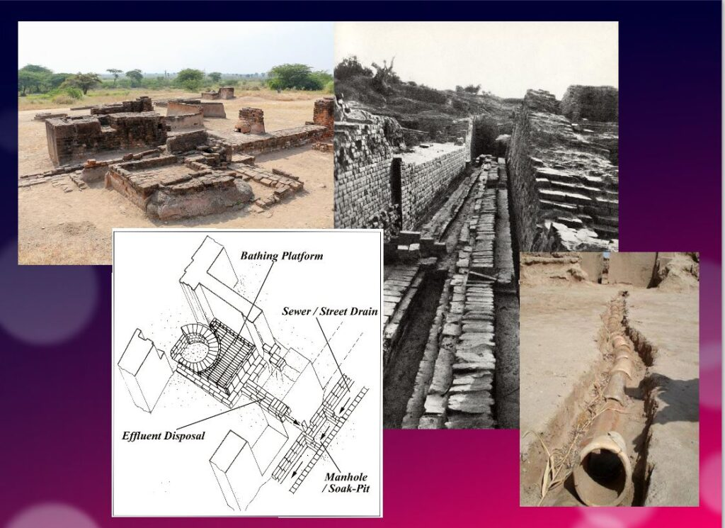
In the port city of Lothal (now India), for example, many homes had private brick bathrooms and latrines. Wastewater was evacuated via a communal sewage system leading either to a canal in the port, or to a soaking pit outside the city walls, or to buried urns equipped with a hole for the evacuation of liquids, which were regularly emptied and cleaned.
Excavations at the Mohenjo Daro site reveal the existence of no fewer than 700 brick wells, houses equipped with bathrooms and individual and collective latrines.
Many of the city’s buildings had two floors or more. Water trickled down from cisterns installed on the roofs was channeled through closed clay pipes or open gutters that emptied into the covered sewers beneath the street.
This hydraulic and sanitary know-how was passed on to the civilization of Crete, the mother of Greece, before being implemented on a large scale by the Romans.
It was forgotten with the collapse of the Roman Empire, only to return during the Renaissance.
The first human contributions were aimed at maximizing water reservoirs and their gravity-flow capacity. To achieve this, it was necessary to transfer water from a lower level to higher ground and build « water towers ».
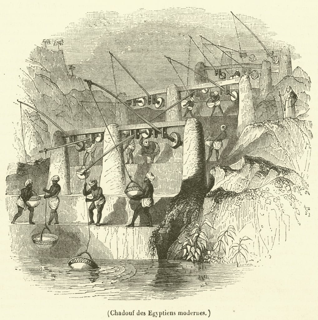
To this end, the Mesopotamian « chadouf » was widely used in Egypt, followed by the « Archimedean screw ».
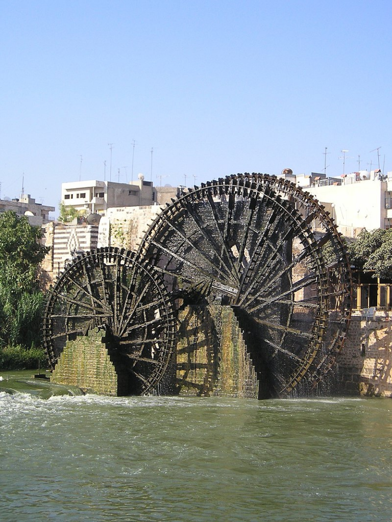
Next came the « saquia » or « Persian wheel », a geared wheel driven by animal power, and finally the « noria », the best-known water-drawing machine, powered by the river itself.
Persian qanats
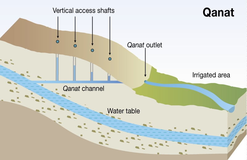
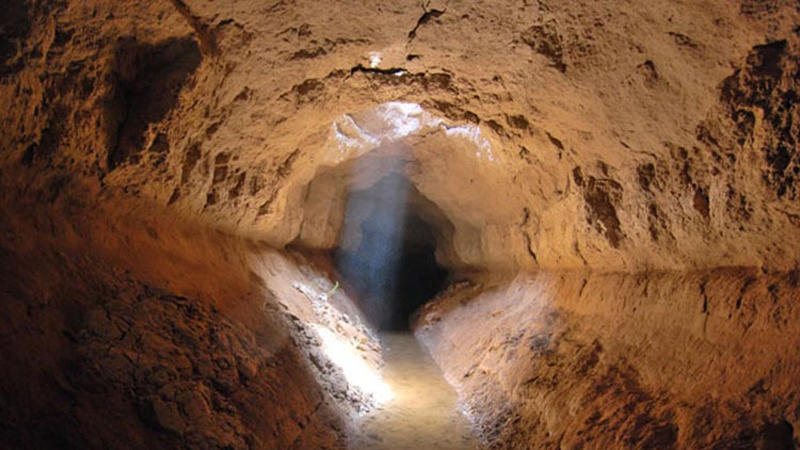
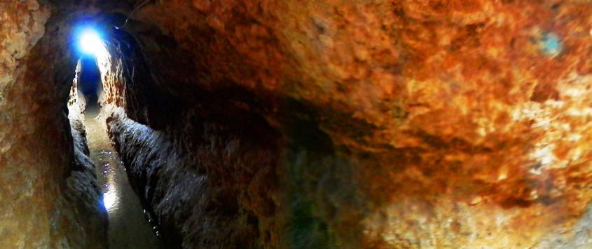
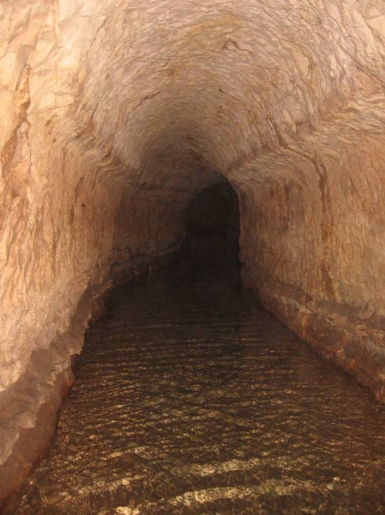
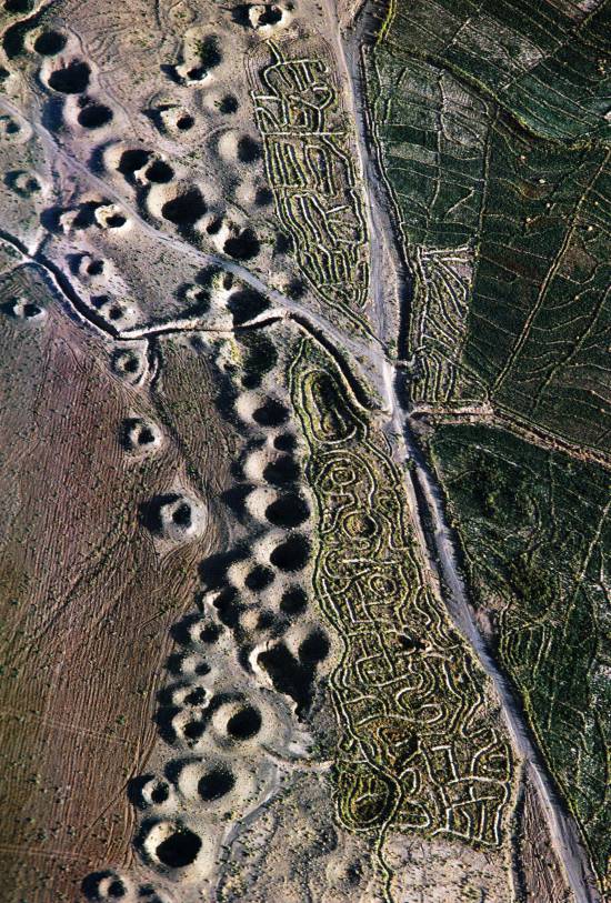
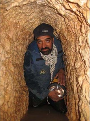
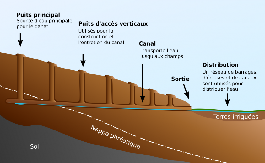
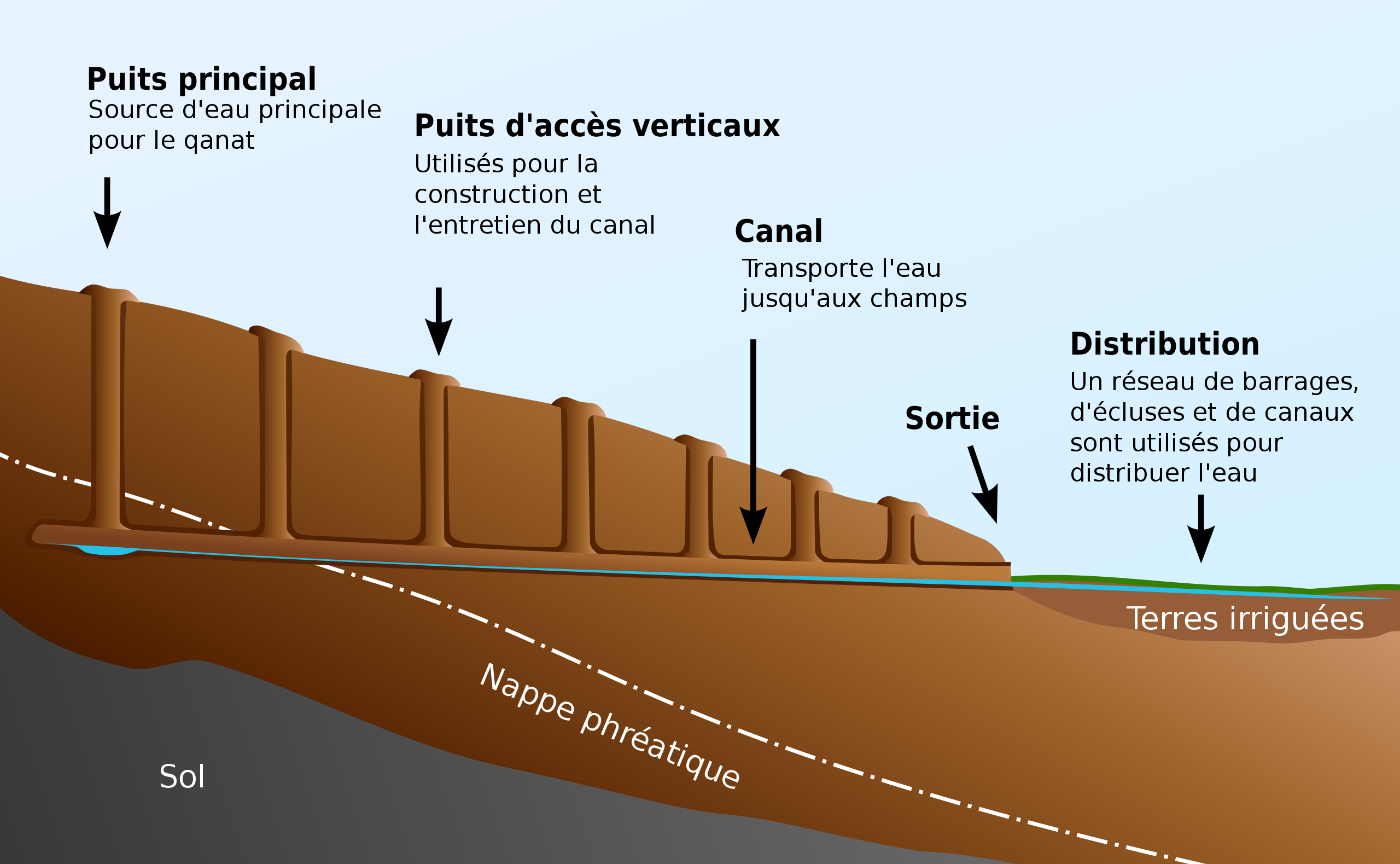
Before Alexander the Great, Persia’s Achaemenid Empire (6th century BC) developed the technique of underground qanats or underground aqueducts. This « draining gallery” cut into the rock or built by man, is one of the most ingenious inventions for irrigation in arid and semi-arid regions.
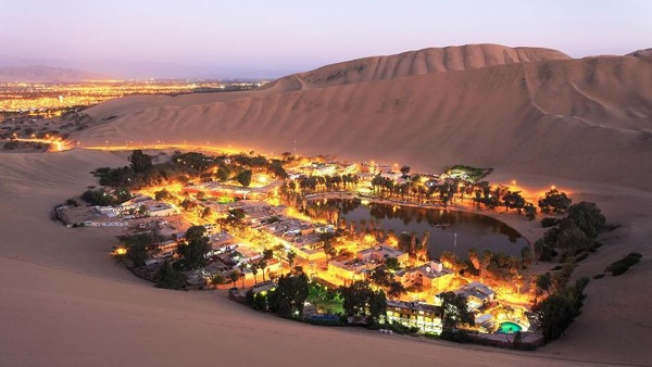
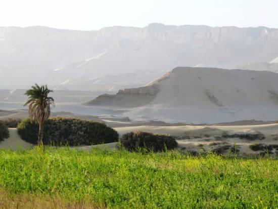
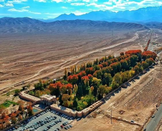
Whatever displeases our environmentalist friends, it’s not nature that magically produces « oases » in the desert.
It’s a scientific man who digs a drainage gallery from a water table close enough to the ground surface, or sometimes from an aquifer that flows into the desert.
On the website of ArchéOrient, archaeologist Rémy Boucharlat, Director of Emeritus Research at the French CNRS, an expert on Iran, explains:
« Whatever the origin of the water, deep or shallow, the gallery construction technique is the same. The first step is to identify the presence of the water, either its underflow near a river, or the presence of a deeper water table on a foothill, which requires the science and experience of specialists.
A motherwell reaches the upper part of this layer or water table, which indicates the depth at which the gallery should be dug. The slope of the gallery must be very shallow, less than 2‰, to ensure a calm and regular flow of water, and to gradually lead the water to the surface, at a gradient much lower than the slope of the piedmont.
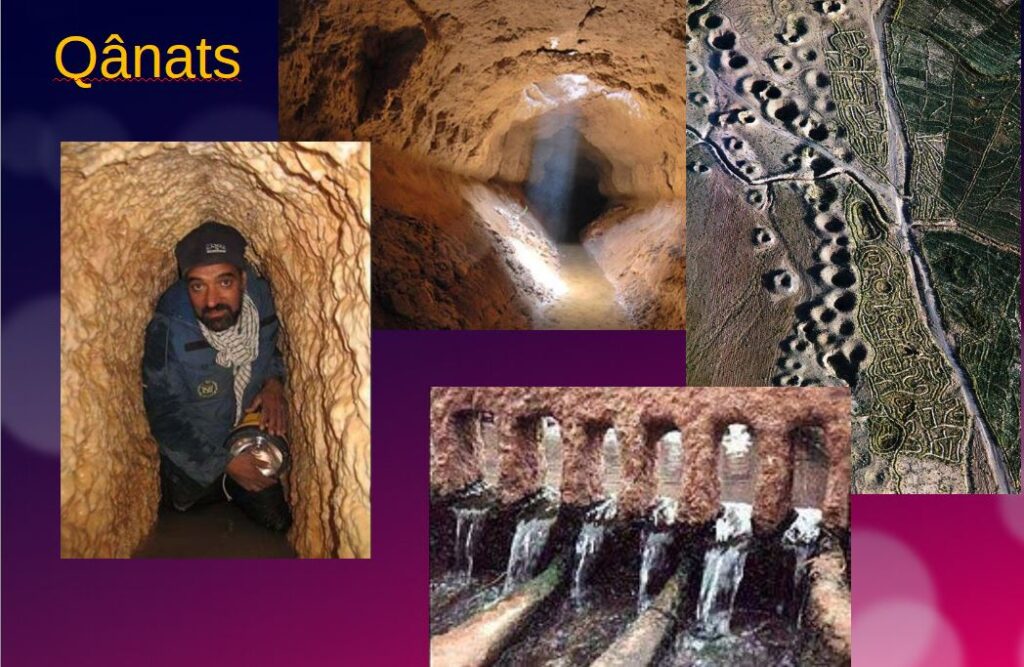
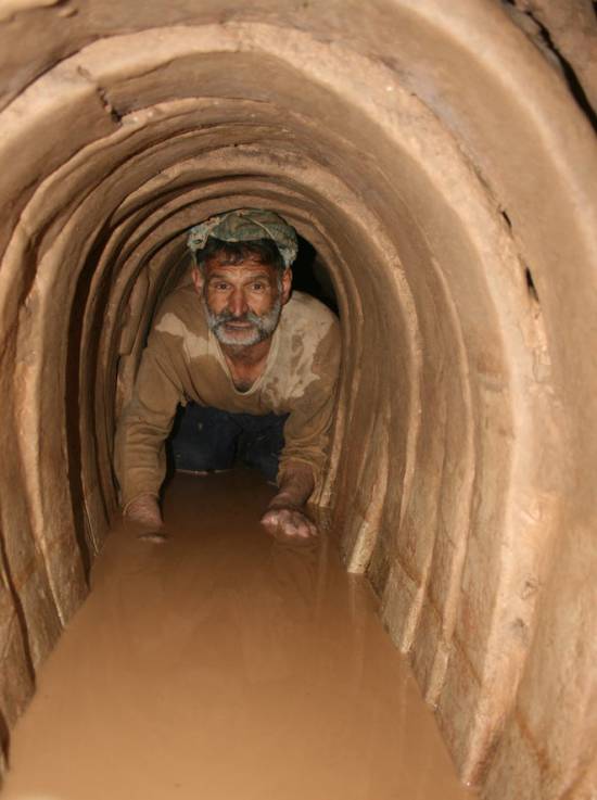
The gallery is then excavated, not from the mother well, as it would be flooded immediately, but from downstream, from the arrival point. The pipe is first dug as an open trench, then covered, and finally gradually tunnelled into the ground.
Shafts are dug from the surface at regular intervals, between 5 and 30 m depending on the nature of the terrain, to evacuate soil and provide ventilation during excavation, and to mark the direction of the tunnel.”
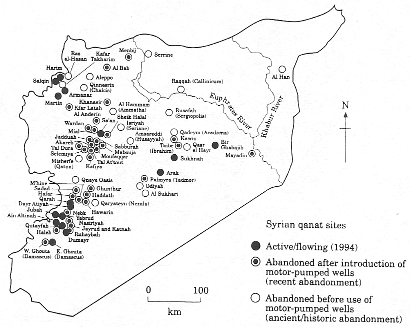
Historically, the majority of the populations of Iran and other arid regions of Asia and North Africa depended on the water supplied by qanats; settlement areas thus corresponded to the places where their construction was possible.
The technique offers a significant advantage: as the water moves through an underground conduit, not a drop of water is lost through evaporation.
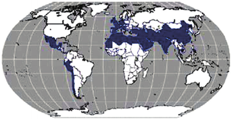
This technique spread throughout the world under various names: qanat and kareez in Iran, Syria and Egypt, kariz, kehriz in Pakistan and Afghanistan, aflaj in Oman, galeria in Spain, kahn in Balochistan, kanerjing in China, foggara in North Africa, khettara in Morocco, ngruttati in Sicily, bottini in Siena, etc.).
Improved by the Greeks and amplified by the Etruscans and the Romans, the qanats technique was carried by the Spaniards across the Atlantic to the New World, where numerous underground canals of this type still operate in Peru, Chile and western Mexico.
After Alexander the Great, Bactria, covering parts of today’s Uzbekistan, Turkmenistan and the northern part of Afghanistan, was even known as the « Oasis civilization » or the “Land of a 1000 Golden Cities”.
Iran boasts it had the highest number of qanats in the world, with approximately 50,000 qanats covering a total length of 360,000 km, about 9 times the circumference of the Earth !
Thousands of them are still operational but increasingly destabilized by erratic well digging and demographic overconcentration.
Shared responsability
In 1017, the Baghdad-based hydrologist Mohammed Al-Karaji provided a detailed description of qanat construction and maintenance techniques, as well as legal considerations about the collective management of wells and pipes.
While each qanat is designed and supervised by a mirab (dowser-hydrologist and discoverer), building a qanat is a collective task that takes several months or years for a village or group of villages. The absolute necessity of collective investment in the infrastructure and its maintenance calls for a superior notion of the common good, an indispensable complement to the notion of private property that rains and rivers are not accustomed to respecting.
In North Africa, the management of water distributed by a khettara (the local name for qanâts) is governed by traditional distribution norms known as « water rights ».
Originally, the volume of water granted per user was proportional to the work involved in building the khettara, and translated into an irrigation period during which the beneficiary could use all the khettara’s flow for his or her fields. Even today, when the khettara has not dried up, this rule of water rights still applies, and a share can be bought or sold. The size of each family’s fields to be irrigated must also be taken into account
All of this demonstrates that good cooperation between man and nature can do miracles if man decides so.
Thank you for your attention and questions welcome!
Persian Qanâts and the Civilization of Hidden Waters

By Karel Vereycken, July 2021.

By Karel Vereycken, July 2021.
At a time when old diseases make their return and new ones emerge worldwide, the tragic vulnerability of much of humanity poses an immense challenge.
One wonders whether to laugh or cry when international authorities trumpet without further clarification that to stop the Covid-19 pandemic, “all you have to do” is “wash your hands with soap and water”!
They forget one small detail: 3 billion people do not have facilities to wash their hands at home and 1.4 billion have no access to either water or soap!
Yet, since the dawn of time, mankind has demonstrated its capacity to mobilize its creative genius to make water available in the most remote places.
Here is a short presentation of a marvel of such human genius, the “qanâts”, an underground water conveyance system dating from the Iron Age. Probably of Egyptian origin, it was deployed on a large scale in Persia from the beginning of the 1st millennium BC.
The qanât or underground aqueduct

Sometimes called “horizontal drilling”, the qanât is an underground aqueduct employed to draw water from a water table and convey it by simple gravitational effect to urban settlements and farmland. The word qanât is an old Semitic word, probably Accadian, derived from a root qanat (reed) from which come canna and canal.
This “drainage gallery”, cut into the rock or built by man, is certainly one of the earliest and most ingenious inventions for irrigation in arid and semi-arid regions. The technique offers a significant advantage: by conveying water through an underground conduit, contrary to open air canals, not a single drop of water is wasted by evaporation.
Oases’ are NOT natural phenomena. All known oases are man-made. It is the qanât technique that allows man, in a given geographic configuration, to create oases in the middle of the desert, when a water table is close enough to the ground level or at a site close to the bed of a river lost in the sands of the desert.
Copied and expanded by the Romans, the qanât technique was carried across the Atlantic to the New World by the Spaniards, where many such underground canals still function in Peru and Chile. In fact, there are even Persian qanâts in western Mexico.
While today this three thousand year old technique may not be appropriate everywhere to solve current water scarcity problems in arid and semi-arid regions, it has much to inspire us as a demonstration of human genius at its best, that is, capable of doing a lot with a little.
The oases of Egypt
Today, 95% of the Egyptian population prospers on only 5% of its territory, mainly around the Nile delta. Hence, from the earliest days of Egyptian civilization, irrigation and water storage techniques for the Nile floods were developed in order to conserve this silty, nutrient-rich water for use throughout the year.
The river water was diverted and transported by canals to the fields by gravity. Since water from the Nile did not reach the oases, the Egyptians used the gushing water from the springs, which came from the large aquifer reserves of the western desert, and conveyed it to the fields by irrigation canals.
One of the fruits of this attempt to “conquer the desert” was a sustained habitation of the Dakhleh oasis throughout the Pharaonic period, explicable not only by a commercial interest on the part of the Egyptian state, but also by the new agricultural perspectives it offered.
Roman aqueducts
Closer to us in time, the Qanât Fir’aun (The Watercourse of the Pharaoh) also known as the aqueduct of Gadara, a city today in Jordan. As far as we know, this 170 km long structure, depending on the geography, combines several bridge-aqueducts (of the same type as the Gard aqueduct in France) and 106 km of underground canals using the Persian qanât technique. It is not only the longest but also the most sophisticated aqueduct of antiquity, and the fruit of a years of hydraulic engineering.
In reality, the Romans, hiring persian water experts, did nothing more than terminate in the 2nd century an ancient project designed to supply water to the “Decapolis”, a collaborative group of ten cities founded by Greek and Macedonian settlers under the Seleucid king Antiochos III (223 – 187 BC), one of the successors of Alexander the Great.
These ten cities were located on the eastern border of the Roman Empire (now in Syria, Jordan and Israel), united by language, culture and political status, each with a degree of autonomy and self-rule. Its capital, Gadara, was home to more than 50,000 people and known for its cosmopolitan atmosphere, its own university attracting scholars, writers, artists, philosophers and poets. But this rich city lacked something existential : an abundance of water.
The Gadara qanat made the difference. “In the capital alone, there were thousands of fountains, watering holes and baths. Wealthy senators cooled themselves in private pools and decorated their gardens with cooling caves. The result was a record daily consumption of more than 500 liters of water per capita,” explains Matthias Schulz, author of a report on the aqueduct in Spiegel Online.
Persia
We all admire the roman aqueducts. But few of us are aware that the Romans only adapted the technique of the qanâts developed much earlier in Persia.
Indeed, it was under the Achaemenid Empire (around 559 – 330 BC.), that this technique spread slowly from Persia to the east and the west. Many qanâts can be found in North Africa (Morocco, Algeria, Libya), in the South East Asia (Iran, Oman, Iraq) and further east, in Central Asia, from Afghanistan to China (Xinjiang), via India.
The development of these “draining galleries” is attested in different regions of the world under various names: qanât and kareez in Iran, Syria and Egypt, kariz, kehriz in Pakistan and Afghanistan, aflaj in Oman, galeria in Spain, kahn in Balochistan, kanerjing in China, foggara in North Africa, khettara in Morocco, ngruttati in Sicily, bottini of Siena, etc.
Historically, the majority of the populations of Iran and other arid regions of Asia or North Africa depended on the water provided by the qanâts; their construction lifted entire areas to a higher “economic platform”, made deserts habitable and opened new land for agriculture. The map of demographic expansion followed the trail of the development of this new higher platform.
In his article « Du rythme naturel au rythme humain : vie et mort d’une technique traditionnelle, le qanât » (From natural rhythm to human rhythm: the life and death of a traditional technique, the qanât), Pierre Lombard, a researcher at the French CNRS, points out that this is not an artisanal and marginal process:
“Until a few years ago, the importance of the ancestral technique of qanât was sometimes ignored in Central Asia, Iran, Syria, and even in the countries of the Arabian Peninsula. For example, the Public Authority for Water Resources of the Sultanate of Oman estimated in 1982 that all the qanâts still in operation conveyed more than 70 % of the total water used in that country and irrigated nearly 55% of the cereal lands. Oman was still one of the few states in the Middle East to maintain and sometimes even develop its qanât network; this situation, apart from its longevity, does not appear to be exceptional. If one turns to the edges of the Iranian Plateau, one can note with Wulff (1968) the obvious discrepancy between the relative aridity of this area (between 100 and 250 mm of annual precipitation) and its non-negligible agricultural production, and explain it by one of the densest networks of qanâts in the Middle East. It can also be recalled that until the construction of the Karaj dam in the early 1960s, the two million inhabitants of Tehran at that time consumed exclusively the water brought from the Elbourz foothills by several dozen regularly maintained qanâts. Finally, we can mention the case of some major oases in the Near and Middle East (Kharga in Egypt, Layla in Saudi Arabia, Al Ain in the United Arab Emirates, etc.) or in Central Asia (Turfan, in Chinese Turkestan) that owe their vast development, if not their very existence, to this remarkable technique.”
On the website ArchéOrient, the French archaeologist Rémy Boucharlat, Director of Research Emeritus at the CNRS, an Iran expert, explains:
“Whatever the origin of the water, deep or not, the technique of construction of the gallery is the same. First, the issue is to identify the presence of water, either its going underground near a river, or the presence of a water table under a foothill, which requires the science and experience of specialists. A motherwell will be dug to reach the top of the water table, indicating at which depth the [horizontal] gallery should be drilled. It’s slope must be very small, less than 2‰, so that the flow of water is calm and regular, and conduct the water gradually to the surface area, according to a gradient much lower than the slope of the foothill.
“The gallery is then dug, not starting from the mother well because it would be immediately flooded, but from downstream, from the point of arrival. The conduct is first dug in an open trench, then covered, and finally gradually sinks into the ground in a tunnel. For the evacuation of soil and ventilation during excavation, as well as to identify the direction of the gallery, shafts are dug from the surface at regular intervals, between 5 and 30 m depending on the nature of the land ».
In April 1973, Lyndon LaRouche’s friend, the French-Iranian professor and historian Aly Mazahéri (1914-1991), published his translation from Arab into French of “The Civilization of Hidden Waters”, a treatise on the exploitation of underground waters composed in the year 1017 by the Persian hydrologist Mohammed Al-Karaji, who lived in Baghdad. (Translated in English in 2011)
After an introduction and general considerations on geography, natural phenomena, the water cycle, the study of terrain and the instruments of the hydrologist, Al-Karaji gives a highly precise technical outline of the construction and maintenance of qanâts, as well as legal considerations respecting their management and maintenance.
In his introduction to Al-Karji’s treatise, Professor Mazaheri emphasizes the role of the Iranian city of Merv (now in Turkmenistan). This ancient city, he says, was part of
“the long series of oases extending at the foot of the northern slope of the Iranian plateau, from the Caspian to the first foothills of the Pamirs. There, between the geological extension of the Caspian towards the East, there is a strip of arable land, more or less wide, but very fertile. Now, to exploit it, a lot of ingenuity is needed: where, for example in Merv, a big river, such as the Marghab, coming from the glaciers of the central East-Iranian massif, crosses the chain, it is necessary to establish dams, above the strip of arable land, without which, the ‘river’, divided into several dozens of arms, rushes under the sands. Elsewhere, and it is almost all along the northern slope of the chain, one can create artificial oases, by bringing the water by underground aqueducts.” (p. 44)
“The construction of dams and underground aqueducts are among the most interesting legacies of their (the ancient Persians) irrigation techniques (…) Long before Islam, the Persian hydrologists had built thousands of aqueducts, allowing the creation of hundreds of villages, dozens of cities previously unknown. And very often, even where there was a river, because of the insufficiency of this one, the hydronomists had brought to light many aqueducts allowing the extension of the culture and the development of the city. Naishabur was such a city. Under the Sassanids, and later under the Caliphs, an important network of aqueducts had been created there, so that the inhabitants could afford the luxury of owning a ‘’bathing room’ in the basement, at the level of the aqueduct serving the house.”

Let us recall that most Persian scholars, including the famous mathematician Al-Khwarizmi, not suffering from today’s hyper-specialization that tends to curb creative thinking, excelled in mathematics, geometry, astronomy and medicine as well as in hydrology.
Mazaheri confirms that this “civilization of underground waters” spread well beyond the Iranian borders:
“Already, under the [Umayyad] Caliph Hisham (723-42), Persian hydronomists built aqueducts between Damascus and Mecca (…) Later, Mecca suffering from lack of water, Zubayda, the wife of Hâroun Al-Rachîd, sent Persian hydronomists there who endowed the city with a large underground aqueduct. And each time the latter was silted up, a new team left Persia to restore the network: such repairs took place periodically under Al-Muqtadir (908-32), under Al-Qa’im (1031-1075), under Al-Naçir (1180-1226) and, at the beginning of the fourteenth century, under the Mongol prince Emir Tchoban. We would say the same of Medina and the stages on the pilgrimage route, between Baghdad and Mecca, wherever it was possible to do so, hydronomic works were undertaken and ‘underground aqueducts’ were created.
“Hydronomy is a highly demanding skill. To practice it, it is not enough to have mathematical knowledge: decadal calculus, algebra, trigonometry, etc., it is necessary to spend long hours in the galleries at the risk of dying by flooding, landslide or lack of air. It is necessary to have an ancestral instinct of ‘dowser’.”
The annual rainfall in Iran is 273 mm, which is less than one third of the world’s average annual precipitation.
The temporal and spatial distribution of precipitation is not uniform; about 75% occurs in a small area, mainly on the southern coast of the Caspian Sea, while the rest of the country does not receive sufficient rainfall. On the temporal scale, only 25% of the precipitation occurs during the plant growing season.
7,7 x the circonférence of the Earth
Still in use today in Iran, qanâts currently supply about 7.6 billion m3 of water, close to 15% of the country’s total water needs.
Considering that the average length of each qanât is 6 km in most parts of the country, the total length of the 30,000 qanât systems (potentially exploitable today) is about 310,800 km, which is about 7.7 times the circumference of the Earth or 6/7th of the Earth-Moon distance!
This shows the enormous amount of work and energy applied to build the qanâts. In fact, while more than 38,000 qanâts were in operation in Iran till 1966, its number dropped to 20,000 in 1998 and is currently estimated at 18,000. According to the Iranian daily Tehran Times, historically, over 120,000 qanat sites are documented.
Moreover, while in 1965, 30-50% of Iran’s total water needs were met by qanats, this figure has dropped to 15% in recent decades.
According to the Face Iran website:
“The water flow of qanâts is estimated between 500 and 750 cubic meters per second. As land aridity tends to vary according to the abundance of rains in each region, this quantity of water is used as a more or less important supplement. This makes it possible to use good land that would otherwise be barren. The importance of the impact on the desert can be summarized in one figure: about 3 million hectares. In seven centuries of hard work, the Dutch conquered 1.5 million hectares from the marshes or the sea. In three millennia, the Iranians have conquered twice as much on the desert.
Indeed, to each new qanât corresponded a new village, new lands. From where a new human group absorbed the demographic surplus. Little by little the Iranian landscape was constituted. At the end of the qanat, is the house of the chief, often with one floor. It is surrounded by the villagers’ houses, animal shelters, gardens and market gardens.
The distribution of land and the days of irrigation of the plots were regulated by the chief of the villages. Thus, a qanat imposed a solidarity between the inhabitants.”
If each qanât is “invented” and supervised by a mirab (dowser-hydrologist and discoverer), the realization of a qanât is a collective task that requires several months or years, even for medium-sized qanâts, not to mention works of record dimensions (a 300 m deep mother-well, a 70 km long gallery classified in 2016 as a World Heritage Site by UNESCO, in northeast Iran).
Each undertaking is carried out by a village or a group of villages. The absolute necessity of a collective investment in the infrastructure and its maintenance requires a higher notion of the common good, an indispensable complement to the notion of private property that rains and rivers do not take in account.
In the Maghreb, the management of water distributed by a khettara (the local name for qanâts) follows traditional distribution norms called “water rights”. Originally, the volume of water granted per user was proportional to the work contributed to build the khettara, translated into an irrigation time during which the beneficiary had access to the entire flow of the khettara for his fields. Even today, when the khettara has not dried up, this rule of the right to water persists and a share can be sold or bought. Because it is also necessary to take into account the surface area of the fields to be irrigated by each family.
The causes of the decline of the qanâts are numerous. Without endorsing the catastrophist theses of an anti-human ecology, it must be noted that in the face of the increasing urban population, the random construction of dams and the digging of deep wells equipped with electric pumps have disturbed and often depleted the aquifers and water tables.
A neoliberal ideology, falsely described as “modern”, also prefers the individualistic “manager” of a well to a collective management organized among neighbors and villages. A passive State authority has done the rest. In the absence of more thoughtful reflection on its future, the age-old system of qanâts is on the verge of extinction as a result.
In the meantime, the Iranian population has grown from 40 to over 82 million in 40 years. Instead of living off oil, the country is seeking to prosper through agriculture and industry. As a result, the need for water has increased substantially. To cope with rising demands, Iran is desalinating sea water at great cost. Its civilian nuclear program will be the key factor to provide water at a reasonable cost.
Beyond political and religious divisions, closer cooperation between all the countries in the region (Turkey, Syria, Iraq, Israel, Egypt, Jordan, etc.) with a perspective to improve, develop, manage and share water resources, will be beneficial to each and all.
Presented as an “Oasis Plan” and promoted for decades by the American thinker and economist Lyndon LaRouche, such a policy, translating word into action, is the only basis of a true peace policy.
Bibliography :
- Remy Boucharlat, The falaj or qanât, a polycentric and multi-period invention, ArcheOrient – Le Blog, September 2015 ;
- Pierre Lombard, Du rythme naturel au rythme humain : vie et mort d’une technique traditionnelle, le qanat, Persée, 1991 ;
- Aly Mazaheri, La civilisation des eaux cachées, un traité de l’exploitation des eaux souterraines composé en 1017 par l’hydrologue perse Mohammed Al-Karaji, Persée, 1973 ;
- Hassan Ahmadi, Arash Malekian, Aliakbar Nazari Samani, The Qanat: A Living History in Iran, January 2010;
- Evelyne Ferron, Egyptians, Persians and Romans: the interests and stakes of the development of Egyptian oasis environments.
NOTE:
[1] The ten cities forming the Decapolis were: 1) Damascus in Syria, much further north, sometimes considered an honorary member of the Decapolis; 2) Philadelphia (Amman in Jordan); 3) Rhaphana (Capitolias, Bayt Ras in Jordan); 4) Scythopolis (Baysan or Beit-Shean in Israel), which is said to be its capital; It is the only city west of the Jordan River; 5) Gadara (Umm Qeis in Jordan); 6) Hippos (Hippus or Sussita, in Israel); 7) Dion (Tell al-Ashari in Syria); 8) Pella (Tabaqat Fahil in Jordan); 9) Gerasa (Jerash in Jordan) and 10) Canatha (Qanawat in Syria)
Qanâts perses et Civilisation des eaux cachées

Par Karel Vereycken, juillet 2021.
A une époque où d’anciennes maladies reviennent et où de nouvelles émergent à l’échelle mondiale, la vulnérabilité tragique d’une grande partie de l’humanité pose un immense défi.
On se demande s’il faut rire ou pleurer quand les autorités internationales claironnent sans plus de précisions que pour enrayer la pandémie de Covid-19, il « suffit » de bien se laver les mains à l’eau et au savon !
Ils oublient un petit détail : 3 milliards de personnes ne disposent pas d’installations pour se laver les mains chez elles et 1,4 milliard n’ont aucun accès, ni à l’eau, ni au savon !
Pourtant, depuis la nuit des temps, l’homme a su rendre l’eau disponible dans les endroits les plus reculés.
Voici un aperçu d’une merveille du génie humain, les qanâts perses, une technique de canalisations souterraines datant de l’âge de fer. Sans doute d’origine égyptienne, elle fut mise en œuvre à grande échelle en Perse à partir du début du 1er millénaire avant notre ère.
Le qanât ou aqueduc souterrain
Parfois appelé « forage horizontal », le qanât est un aqueduc souterrain servant à puiser dans une nappe phréatique pour l’acheminer par simple effet de gravitation vers des lieux d’habitation et de cultures. Certains qanâts comprennent des aires de repos pour les travailleurs, des réservoirs d’eau, des salles d’eau souterraines et même des moulins à eau. Le mot qanâts, vieux mot sémitique, probablement accadien, dérivé d’une racine qanat (roseau) d’où viennent canna et canal.
Cette « galerie drainante », taillée dans la roche ou construite par l’homme, est certainement l’une des inventions les plus ingénieuses pour l’irrigation dans les régions arides et semi-arides. La technique offre un avantage non négligeable : se déplaçant dans un conduit souterrain, pas une goutte d’eau ne se perd par évaporation.
C’est cette technique qui permet à l’homme de créer des oasis en plein désert, lorsqu’une nappe phréatique est suffisamment proche de la surface du sol ou parfois sur le lit d’une rivière venant se perdre dans le désert.
Copiée et utilisée par les Romains, la technique des qanâts a été transportée par les Espagnols de l’autre côté de l’Atlantique vers le nouveau monde, où de nombreux canaux souterrains de ce type fonctionnent encore au Pérou et au Chili. En fait, il existe même des qanâts perses dans l’ouest du Mexique.
Si aujourd’hui, ce système triplement millénaire n’est pas forcément applicable partout pour résoudre les problèmes de pénurie d’eau dans les régions arides et semi-arides, il a de quoi nous inspirer en tant que démonstration du génie humain dans ce qu’il a de meilleur, c’est-à-dire capable de faire beaucoup avec peu.
Les oasis d’Égypte
Dès les balbutiements de la civilisation égyptienne, des techniques d’irrigation et de stockage de l’eau des crues du Nil furent développées afin de conserver cette eau limoneuse, riche en nutriments, pour l’utiliser tout au long de l’année. L’eau du fleuve était déviée et transportée par canaux vers les champs grâce à la gravité. Puisque l’eau du Nil ne parvenait pas dans les oasis, les Égyptiens utilisèrent l’eau jaillissante des sources, provenant des grandes réserves aquifères du désert de l’Ouest, et acheminée vers les terres par des canaux d’irrigation.
Le résultat de cette tentative de conquête du désert fut une habitation soutenue de l’oasis de Dakhleh tout au long de l’époque pharaonique, explicable non seulement par un intérêt commercial de la part de l’État égyptien, mais aussi par de nouvelles possibilités agricoles.
Aqueducs Romains
Plus proche de nous, le Qanât Fir’aun (Le cours d’eau du Pharaon) également connu comme l’aqueduc de Gadara, aujourd’hui en Jordanie.
En l’état actuel de nos connaissances, cet édifice de 170 kilomètres, qui alterne, en fonction de la géographie, plusieurs pont-aqueducs (du même type que celui du Gard en France) et 106 km de canaux souterrains utilisant la technique des qanâts perses.
Il est aussi le plus long aqueduc de l’Antiquité, et surtout le plus complexe et le fruit d’un long travail d’ingénierie hydraulique.
En réalité, les Romains ont achevé au IIe siècle un vieux projet visant à approvisionner en eau la Décapole, un ensemble de dix villes fondées par des colons grecs et macédoniens sous le roi séleucide Antiochos III (223 – 187 av. JC), un des successeurs d’Alexandre le Grand.
La Décapole était un groupe de dix villes [*] situées à la frontière orientale de l’Empire romain (aujourd’hui en Syrie, en Jordanie et en Israël), regroupées en raison de leur langue, de leur culture, de leur emplacement et de leur statut politique, chacune possédant un certain degré d’autonomie et d’autogestion.
Sa capitale, Gadara, abritait plus de 50 000 personnes et se distinguait par son atmosphère cosmopolite, sa propre université avec des érudits, attirant écrivains, artistes, philosophes et poètes.
Mais il manquait quelque chose à cette ville riche : une abondance d’eau.
Le qanât de Gadara a changé tout cela. « Rien que dans la capitale, il y avait des milliers de fontaines, d’abreuvoirs et de thermes. Les riches sénateurs se rafraîchissaient dans des piscines privées et décoraient leurs jardins de grottes rafraîchissantes. Il en résultait une consommation quotidienne record de plus de 500 litres d’eau par habitant », explique Matthias Schulz, auteur d’un reportage sur l’aqueduc dans Spiegel Online.
La Perse
La technique des qanâts, reprise et mise en œuvre par les Romains, leur était parvenue de Perse.
En effet, c’est sous L’Empire des Achéménides (vers 559 – 330 av. JC.), que cette technique se serait répandue lentement depuis la Perse vers l’est et l’ouest.
On trouve ainsi de nombreux qanâts en Afrique du Nord (Maroc, Algérie, Libye), au Moyen-Orient (Iran, Oman, Irak) et plus à l’est, en Asie centrale, de l’Afghanistan jusqu’en Chine (Xinjiang) en passant par l’Inde.
Ces galeries drainantes ou galeries de captage émergentes sont attestées dans différentes régions du monde sous des noms divers : qanât et kareez en Iran, Syrie et Égypte, kariz, kehriz au Pakistan et en Afghanistan, aflaj à Oman, galeria en Espagne, kahn au Baloutchistan, kanerjing en Chine, foggara en Afrique du Nord, khettara au Maroc, ngruttati en Sicile, bottini à Sienne, etc.).
Historiquement, la majorité des populations d’Iran et d’autres régions arides d’Asie ou d’Afrique du Nord dépendait de l’eau fournie par les qanâts ; les espaces de peuplement correspondaient ainsi aux lieux où leur construction était possible.
Dans son article « Du rythme naturel au rythme humain : vie et mort d’une technique traditionnelle, le qanât », Pierre Lombard, chercheur au CNRS, relève qu’il ne s’agit pas d’un procédé artisanal et marginal :
La technique ancestrale du qanât revêtait il y a quelques années encore une importance parfois méconnue en Asie centrale, en Iran, en Syrie, ou encore dans les pays de la péninsule arabique. A titre d’exemple, la Public Authority for Water Ressources du Sultanat d’Oman estimait en 1982 que l’ensemble des qanâts encore en activité convoyaient plus de 70 % du total de l’eau utilisée dans ce pays et irriguaient près de 55 % des terres à céréales. L’Oman demeurait certes alors l’un des rares Etats du Moyen-Orient à entretenir et parfois même développer son réseau de qanâts ; cette situation, hormis sa longévité, n’apparaît pourtant en rien exceptionnelle. Si l’on se tourne vers les bordures du Plateau iranien, on peut constater avec Wulff (1968) le décalage évident entre la relative aridité de cette zone (entre 100 et 250 mm de précipitations annuelles) et ses productions agricoles non négligeables, et l’expliquer par l’un des plus denses réseaux de qanâts du Moyen-Orient. On peut aussi rappeler que jusqu’à la construction du barrage du Karaj au début des années 60, les deux millions d’habitants que comptait alors Téhéran consommaient exclusivement l’eau apportée depuis le piémont de l’Elbourz par plusieurs dizaines de qanâts régulièrement entretenus. On peut enfin évoquer le cas de quelques oasis majeures du Proche et Moyen-Orient (Kharga en Egypte, Layla en Arabie saoudite, Al Ain aux Émirats arabes unis, etc.) ou d’Asie centrale (Turfan, dans le Turkestan chinois,) qui doivent leur vaste développement, sinon leur existence même à cette technique remarquable.
Sur le site ArchéOrient, l’archéologue Rémy Boucharlat, directeur de Recherche émérite au CNRS, spécialiste de l’Iran, explique :
Quelle que soit l’origine de l’eau, profonde ou non, la technique de construction de la galerie est la même. Il s’agit d’abord de repérer la présence de l’eau, soit son sous-écoulement à proximité d’un cours d’eau, soit la présence d’une nappe plus profonde sur un piémont, ce qui nécessite la science et l’expérience de spécialistes. Un puits-mère atteint la partie supérieure de cette couche ou nappe d’eau, qui indique à quelle profondeur devra être creusée la galerie. La pente de celle-ci doit être très faible, moins de 2‰, afin que l’écoulement de l’eau soit calme et régulier, et pour conduire peu à peu l’eau vers la surface, selon un gradient bien inférieur à la pente du piémont.
La galerie est ensuite creusée, non pas depuis le puits-mère car elle serait immédiatement inondée, mais depuis l’aval, à partir du point d’arrivée. Le conduit est d’abord creusé en tranchée ouverte, puis couverte, pour enfin s’enfoncer peu à peu dans le sol en tunnel. Pour l’évacuation des terres et la ventilation pendant le creusement, ainsi que pour repérer la direction de la galerie, des puits sont creusés depuis la surface à intervalles réguliers, entre 5 et 30 m selon la nature du terrain.
En avril 1973, notre ami, le professeur et historien franco-iranien Aly Mazahéri (1914-1991), publia sa traduction de La civilisation des eaux cachées, un traité de l’exploitation des eaux souterraines composé en 1017 par l’hydrologue perse Mohammed Al-Karaji, qui vécut à Bagdad.
Après une introduction et des considérations générales sur la géographie du globe, les phénomènes naturels, le cycle de l’eau, l’étude des terrains et les instruments de l’hydronome, Al-Karaji donne une description technique de la construction et de l’entretien des qanâts, ainsi que des considérations juridiques sur la gestion des puits et des conduites.
Dans son introduction au traité d’Al-Karji, le professeur Aly Mazahéri souligne le rôle de la ville iranienne de Merv (aujourd’hui au Turkménistan).
Cette ville antique faisait partie de
la longue série d’oasis s’étendant au pied du versant nord du plateau iranien, de la Caspienne aux premiers contreforts des Pamirs. Là, entre l’extension géologique de la Caspienne vers l’Est, se trouve une bande de terre arable, plus ou moins large, mais fort riche. Or, pour l’exploiter, il faut énormément d’ingéniosité : là où, par exemple à Merv, un grand cours d’eau, tel le Marghab, issu des glaciers du massif central est-iranien, franchit la chaîne, il faut établir des barrages, au-dessus de la bande de terre arable, sans quoi, le ’fleuve’ divisé en plusieurs dizaines de bras se précipite sous les sables. Ailleurs, et c’est presque tout au long du versant nord de la chaîne, on peut créer des oasis artificielles, en amenant l’eau par des aqueducs souterrains. (p. 44)
La construction de barrages et celle d’aqueducs souterrains sont parmi les legs les plus intéressants de leurs techniques d’irrigation (…) Bien avant l’islam, les hydronomes perses avaient construit des milliers d’aqueducs, permettant la création de centaines de villages, de dizaines de villes auparavant inconnues. Et très souvent, là même où il y avait une rivière, en raison de l’insuffisance de celle-ci, les hydronomes avaient mis au jour nombre d’aqueducs permettant l’extension de la culture et le développement de la ville. Naishabur était une ville de ce genre. Sous les Sassanides, puis sous les califes, un important réseau d’aqueducs y avait été créé, de sorte que les habitants pouvaient s’offrir le luxe de posséder chacun une ‘salle d’eau’ au sous-sol, au niveau de l’aqueduc desservant la maison.
Rappelons que la plupart des savants perses, notamment le fameux mathématicien Al-Khwarizmi, ne souffrant pas de l’hyper spécialisation qui tend à brider la pensée créatrice, excellaient aussi bien en mathématique, en géométrie, en astronomie et en médecine qu’en hydrologie.
Mazaheri confirme que cette « civilisation des eaux souterraines » s’est répandue bien au-delà des frontières iraniennes :
Déjà, sous le calife Hisham (723-42), des hydronomes persans construisirent entre Damas et La Mecque des aqueducs (…) Plus tard, La Mecque souffrant du manque d’eau, Zubayda, l’épouse de Hâroun Al-Rachîd, y envoya des hydronomes persans qui dotèrent la ville d’un grand aqueduc souterrain. Et chaque fois que celui-ci venait à être ensablé, une nouvelle équipe partait de Perse pour y restaurer le réseau : de telles réfections eurent lieu périodiquement sous Al-Muqtadir (908-32), sous Al-Qa’im (1031-1075), sous Al-Naçir (1180-1226) et, au début du XIVe siècle, sous le prince mongol l’émir Tchoban. Nous dirions autant de Médine et des étapes sur la route du pèlerinage, entre Bagdad et La Mecque, partout où il était possible de le faire, des travaux hydronomiques furent entrepris et des ‘aqueducs souterrains’ furent créés.
« L’hydronomie est un art pénible. Il ne suffisait pas, pour l’exercer, de posséder des connaissances mathématiques : calcul décadique, algèbre, trigonométrie, etc., il fallait passer de longues heures dans les galeries au risque d’y mourir par inondation, éboulement ou manque d’air. Il fallait posséder un instinct ancestral de ‘sourcier’.
Les précipitations annuelles en Iran sont de 273 mm, soit moins d’un tiers des précipitations annuelles moyennes mondiales.
La distribution temporelle et spatiale des précipitations n’est pas uniforme ; environ 75 % concernent une petite zone, principalement sur la côte sud de la mer Caspienne, alors que le reste du pays ne reçoit pas de précipitations suffisantes. À l’échelle temporelle, seulement 25 % des précipitations ont lieu pendant la saison de croissance des plantes.
Les qanâts iraniens : 7,7 x la circonférence de la Terre
Toujours utilisés aujourd’hui, les qanâts sont construits comme une série de tunnels souterrains et de puits qui amènent les eaux souterraines à la surface. Aujourd’hui, en Iran, ils fournissent environ 7,6 milliards de m3, soit 15 % du total des besoins en eau du pays.
Si l’on considère que la longueur moyenne de chaque qanât est de 6 km dans la plupart des régions du pays, la longueur totale des 30 000 systèmes de qanât (potentiellement exploitables aujourd’hui) est d’environ 310 800 km, soit environ 7,7 fois la circonférence de la Terre ou 6/7 de la distance Terre-Lune !
Cela montre l’énorme travail et l’énergie utilisés pour la construction des qanâts. En fait, alors que plus de 38 000 qanats étaient en activité en Iran jusqu’en 1966, ce nombre est tombé à 20 000 en 1998 et est actuellement estimé à 18 000. Selon le quotidien iranien Tehran Times, plus de 120 000 sites de qanâts sont documentés.
De plus, alors qu’en 1965, 30 à 50 % des besoins totaux en eau de l’Iran étaient couverts par les qanâts, ce chiffre est tombé à 15 % au cours des dernières décennies.
Comme le précise le site Face Iran :
Le débit des qanâts est estimé entre 500 et 750 mètres-cubes seconde. Comme l’aridité n’est pas totale, cette quantité sert d’appoint plus ou moins important suivant l’abondance des pluies de chaque région. Ceci permet d’utiliser de bonnes terres qui seraient autrement stériles. L’importance de l’emiètement ainsi réalisé sur le désert se résume en un chiffre : environ 3 millions d’hectares. En sept siècles de travail acharné, les Hollandais conquirent sur les marais ou sur la mer 1,5 million d’hectares. En trois millénaires, les Iraniens ont conquis le double sur le désert.
En effet, à chaque nouveau qanât correspondait un nouveau village, de nouvelles terres. D’où un nouveau groupe humain absorbait les excédents démographiques. Peu à peu se constituait le paysage iranien. Au débouché du qanât, se trouve la maison du chef, souvent à un étage. Elle est entouré des maisons des villageois, des abris des animaux, de jardins et de cultures maraichères.
La distribution des terrains et les jours d’irrigation des parcelles étaient réglés par le chef des villages. Ainsi un qanât imposait une solidarité entre les habitants.
Si chaque qanât est conçu et surveillé par un mirab (sourcier-hydrologue et découvreur), réaliser un qanât est un travail collectif qui demande plusieurs mois ou années, même pour les qanâts de dimensions moyennes, sans même parler des ouvrages aux dimensions records (puits-mère de 300 m de profondeur, galerie longue de 70 km classée en 2016 au Patrimoine mondial de l’humanité par l’UNESCO, dans le nord-est de l’Iran).
L’entreprise est réalisée par un village ou un groupe de villages. La nécessité absolue d’un investissement collectif dans l’infrastructure et sa maintenance nécessite une notion supérieure du bien commun, complément indispensable à la notion de propriété privée que les pluies et les fleuves n’ont guère l’habitude de respecter.
Au Maghreb, la gestion des eaux distribuées par une khettara (nom local des qanâts) obéit à des normes traditionnelles de répartition appelées « droit d’eau ». À l’origine, le volume d’eau octroyé par usager était proportionnel aux travaux fournis lors de l’édification de la khettara et se traduisait en un temps d’irrigation durant lequel le bénéficiaire disposait de l’ensemble du débit de la khettara pour ses champs. Encore aujourd’hui, lorsque la khettara n’est pas tarie, cette règle du droit d’eau perdure et une part peut se vendre ou s’acheter. Car il faut aussi prendre en compte la superficie des champs à irriguer de chaque famille.
Le déclin
Les causes du déclin des qanâts sont multiples. Sans endosser les thèses catastrophistes d’une écologie anti-humaine, force est de constater que face à l’augmentation de la population urbaine, la construction irréfléchie de barrages et le creusement de puits profonds équipés de pompes électriques, ont perturbé et souvent épuisé les nappes phréatiques.
Une idéologie néolibérale, faussement qualifiée de « moderne », préfère également le « manager » d’un puits à une gestion collective entre voisins et villages. Un Etat absent a fait le reste. Faute d’une réflexion plus réfléchie sur son avenir, le système millénaire des qanâts est en voie de disparition.
Entretemps, la population iranienne est passé de 40 à plus de 82 millions d’habitants en 40 ans. Au lieu de vivre de la rente pétrolière, le pays cherche à prospérer grâce à son agriculture et son industrie. Du coup, les besoins en eau explosent. Pour y faire face, l’Iran procède au dessalement de l’eau de mer. Son programme nucléaire civil sera la clé pour en réduire le coût.
Au-delà des divisions politiques et religieuses, une coopération resserrée entre tous les pays de la région (Turquie, Syrie, Irak, Israël, Egypte, Jordanie, etc.) en vue de l’amélioration, du partage et de la gestion des ressources hydriques, sera forcément bénéfique à chacun.
Présentée comme un « Plan Oasis » et promue depuis des décennies par le penseur et économiste américain Lyndon LaRouche, une telle politique, bien mieux que milles traités et autant de paroles, est la base même d’une véritable politique de paix.
Bibliographie :
- Remy Boucharlat, Le falaj ou qanât, une invention polycentrique et multipériode, ArcheOrient – Le Blog, septembre 2015 ;
- Pierre Lombard, Du rythme naturel au rythme humain : vie et mort d’une technique traditionnelle, le qanat, Persée, 1991 ;
- Aly Mazaheri, La civilisation des eaux cachées, un traité de l’exploitation des eaux souterraines composé en 1017 par l’hydrologue perse Mohammed Al-Karaji, Persée, 1973 ;
- Hassan Ahmadi, Arash Malekian, Aliakbar Nazari Samani, The Qanat : A Living History in Iran, janvier 2010 ;
- Evelyne Ferron, Egyptiens, Perses et Romains : les intérêts et les enjeux du développement des milieux oasiens égyptiens.
[*] Les dix villes formant la Décapole étaient : 1) Damas en Syrie, bien plus au nord, parfois considérée comme un membre honorifique de la Décapole ; 2) Philadelphia (Amman en Jordanie) ; 3) Rhaphana (Capitolias, Bayt Ras en Jordanie) ; 4) Scythopolis (Baysan ou Beït-Shéan en Israël), qui en serait la capitale ; c’est la seule ville à se trouver à l’ouest du Jourdain ; 5) Gadara (Umm Qeis en Jordanie) ; 6) Hippos (Hippus ou Sussita, en Israël) ; 7) Dion (Tell al-Ashari en Syrie) ; 8) Pella (Tabaqat Fahil en Jordanie) ; 9) Gerasa (Jerash en Jordanie) et 10) Canatha (Qanawat en Syrie).