Étiquette : water

Contemporary Art Curator Magazine interviews Karel Vereycken on what went wrong with Modern Art


On December 1, the United Arab Emirates based Contemporary Art Curator Magazine published a long, in depth interview with Karel Vereycken, his creative methods and his view on what went wrong with Modern and Contemporary Art.
Contemporary Art Curator Magazine is a leading contemporary art magazine, available in both online and print formats, dedicated to promoting and supporting contemporary artists. It has built a reputation for curating exceptional contemporary art from around the globe.
Founded in 2014, the magazine has consistently supported emerging and established artists, highlighting their work and contributions to the art world.

Karel Vereycken awarded in « 8th Water » art contest


This summer, I crafted an engraving which I named « H2O ». Days later, I discovered there was an international juried art competition on the theme of « Water » organized by the Art Show International Gallery, currently known as Teravarna. So I decided to participate.

On Sept. 20, , Teravarna informed me :
« We’re delighted to bring you the exciting news that you have won an award in the « 8th WATER » art competition. The exhibition of your winning artwork is currently being displayed in our winner’s gallery: https://www.teravarna.com/winners-2025-water-8
Again, congratulations on your well-deserved win, and we hope to highlight many more of your artistic contributions for our upcoming exhibitions. »

1953-1968: When « Water for Peace » was at the Center of US Politics

By Karel Vereycken, May 2024.

The current unprecedented bloody extermination of the Palestinians in Gaza reminds historians of some of the darkest pages of European history. Between 1940 and 1943, some 300,000 Jews confined in the Ghetto of Warsaw were killed by bullet or gas, combined with 92,000 victims of starvation and related diseases, the Ghetto’s Uprising, and the casualties of its final destruction.
Not in our name and never again! Only an immediate and durable cease-fire, concluded in the context of regional agreements for mutually beneficial reconstruction, can offer a perspective where peace becomes thinkable either in the form of two States, one State, or maybe even better, as a confederation. That might look ambitious and even Utopian.
This article looks at the ambitious proposals put on the table after the six days war of 1967, when major forces in the world stepped in and proposed, including by the smart use of civilian nuclear power, to increase the carrying capacity of the entire region. Nuclear desalination facilities and abundant energy from nuclear and hydropower, they thought, can provide the optimum conditions for both Israeli’s and Palestinian’s to have access to abundant fresh water for agriculture, industry and living.
The shock of the six year’s war
In June 1967, following border clashes over water resources and what appeared as a military mobilization of its Arab neighbors, Israel staged a sudden preemptive war against Egypt, Jordan and Syria.
- On June 5th, it destroyed more than 90 percent of Egypt’s air force on the tarmac. A similar air assault incapacitated the Syrian air force. Within three days the Israelis had achieved an overwhelming victory on the ground.
- On June 7, Israeli forces drove Jordanian forces out of East Jerusalem and most of the West Bank. The UN Security Council called for a cease-fire on June 7 that was immediately accepted by Israel and Jordan. Egypt accepted the following day. Syria held out, however, and continued to shell villages in northern Israel.
- On June 9 Israel launched an assault on the fortified Golan Heights, capturing it from Syrian forces after a day of heavy fighting. Syria accepted the cease-fire on June 10. Israel’s decisive victory included the capture of the Sinai Peninsula, Gaza Strip, West Bank, Old City of Jerusalem, and Golan Heights; the status of these territories subsequently became a major point of contention in the Arab-Israeli conflict.
The Arab countries’ losses in the conflict were disastrous. Egypt’s casualties numbered more than 11,000, with 6,000 for Jordan and 1,000 for Syria, compared with only 700 for Israel. The conflict resulted in hundreds of thousands of refugees and brought more than one million Palestinians in the occupied territories under Israeli rule.
Months after the war, in November, the United Nations passed UN Resolution 242, which called for Israel’s withdrawal from the territories it had captured in the war in exchange for lasting peace.
For most western elites, including most Jewish elites all over the world, the 6 day war came both as a shock and a reminder that the two main causes of war had been left unsolved: refugees (that of Palestinians pushed out and Jews arriving) and water access for all.
The « Johnston Plan » for water sharing
In the early 50’s, at the request of the United Nations Refugee Works Administration (UNRWA), experts of the US Tennessee Valley Authority (TVA), had designed an equitable water sharing program for the entire Jordan basin involving Israel, Palestine, Lebanon, Jordan and Syria.
Just as the orginal TVA, by building irrigation canals and dams, the program would have allowed the exansion of irrigated farmland and upshifting the economy and the living standards with energy from hydro-power.
In 1953, Eisenhower, pressured by his Secretary of State John Foster Dulles, sent Eric Johnston as his envoy to convince all the nations of the region to adopt the scheme known as the “Johnston plan.” To avoid countries willing to escape colonial exploitation joining the Communist or neutralist bloc, they argued, the US should offer development programs and « keep them on the right side of history. »
In Southwest Asia, a wonderful and well thought water sharing program was about to be adopted.
Unfortunately, Eisenhower, on March 28, 1956, approved the secret OMEGA Memorandum whose aim was to effect a reorientation of Nasser’s policies toward cooperation with the West while diminishing what were seen as his harmful attempts to influence other Middle East countries. Nasser, the first after Nepal, without informing his allies, had recognized Communist China on May 16. Pertaining to measures directed at Egypt, the provisions included a delay by the United States and Britain in concluding negotiations on financing the Aswan Dam.
As a result, John Foster Dulles, in cahoots with the British and the US southern cotton lobby1 , went ahead with suspending US financing of the Aswan dam (90%) which Nasser needed to irrigate farmland at home.
On Thursday July 19, 1956, Dulles asked the Egyptian Ambassador in Washington, Mr. Ahmed Hussein, to come to his office. When he arrived Mr. Dulles handed him a letter announcing the withdrawal of the United States offer to grant $56,000,000 towards financing the construction of the High Dam at Aswan.2
This decision unleashed a chain of events leading to the famous “Suez crisis” which Eisenhower fortunately brought to a halt once he realized it could end up in a nuclear conflict.
As a result, the most precious aspect of the “Johnston plan” for the ME, that of mutual trust building around the perspective of a shared, common future, was ruined after the Suez affair.
Those that should have been partners of one single global plan to share the waters of the Jordan basin, went for it alone. Israel went ahead with its own National Water Carrier, tapping fresh water from the Sea of Galilee into a water conveyance systems bringing water from the northern border with Lebanon to the Negev desert deep South.
Jordan, with US financing, built the Eastern Ghor water conveyance system, now called “King Abdullah Canal”, to provide water for Jordan’s agriculture and capital while Syria constructed a dam on the Yarmuk, one of the tributaries of the Jordan river. 3
Nuclear desalination, the talk of the Day

Immediately after the six days war, however, the perspective of a massive investment in water and energy to solve the refugee and water crisis in the Middle East, became the talk of the day.
By these dramatic events, thanks to the men and women willing to answer them, the science, the technology and many of the plans elaborated between 1945 and 1967 to use nuclear power for peaceful aims came back on the table.
Key in this was leading US nuclear physicist Alvin Weinberg, who was the administrator of Oak Ridge National Laboratory (ORNL) during and after the Manhattan Project.
Weinberg was appointed in 1960 to the President’s Science Advisory Committee in the Eisenhower administration and later served on it in the Kennedy administration.
Weinberg inspired and organized his networks to propose projects for the peaceful use on civilian nuclear power. Weinberg’s career was brutally terminated when he was fired by Nixon in 1973 for pleading, just as Edward Teller did before his death, in favor of thorium fueled molten salt reactors (which don’t produce plutonium for nuclear bombs).
Water for Peace Conference of May 1967

Tragically and sadly, hardly three weeks before the Six day war, an international conference on “Water for Peace”, was held May 23-31, 1967, in Washington. President Lyndon Johnson (democrat) addressed the conference during the opening ceremonies, pledging that the United States would:
« continue work in every area which holds promise for the world’s water needs, » and would « share the fruits of this technology [nuclear desalination] with all of those who wish to share it with us. » 4
The Department of State Office of International Scientific and Technological Affairs considered the conference a « complete success, » and an internal report noted that,
« 94 countries were represented together with 24 international organizations; 635 official delegates, 61 participants from international organizations, and over 2,000 observers attended. » 5
One of the technical papers presented at the Water for Peace conference, entitled « Desalted Water for Agriculture » by Weinberg’s friend and colleague R. Philip Hammond, hypothesized that, with demonstrated methods of agriculture and « virtually demonstrated » methods of nuclear desalting, food could be grown with water costing 3 cents per day per person.
Alvin Weinberg was convinced, based on the work of his own institution, that these price estimates were « not unreasonable. »

After reading the paper in draft, Weinberg determined that more research was needed, and passed the paper on to Dr. J. George Harrar at the Rockefeller Foundation because of its « longstanding interest in the development of countries, such as Mexico, that suffer from a lack of water. »
Harrar, speaking about a recent discussion he had with Israeli President David Ben-Gurion, said:
« I understand that it is his hope and plan that atomic power for water desalination may become a reality in the Negev one day. »6
Weinberg reported that Atomic Energy Commission (AEC) Chairman Glenn T. Seaborg and AEC Commissioner James T. Ramey had “expressed interest in such agro-industrial complexes in several of their recent speeches. » 7
In a visionary speech, called “The Next Stage of Nuclear Energy,” Weinberg developed even more this idea of building “Food factories in the desert”:
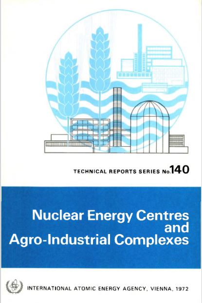
“One can now visualize a new kind of desert agriculture, conducted in units so highly rationalized as to be designated « food factories » rather than farms. In these food factories, plants would be watered and fertilized at precisely the right time, and in precisely the right amounts. Fortunately fertile coastal deserts suitable for such food factories occur in many parts of the world.
The food factory would naturally be accompanied by other energy-intensive chemical processes, particularly those based on electrolytic hydrogen. I have already mentioned production of ammonia; one could imagine other processes such as reduction of iron ore by hydrogen, or electrolytic refining of bauxite to produce aluminium, or production of caustic and chlorine, and thence polyvinyl chloride (PVC) plastics.
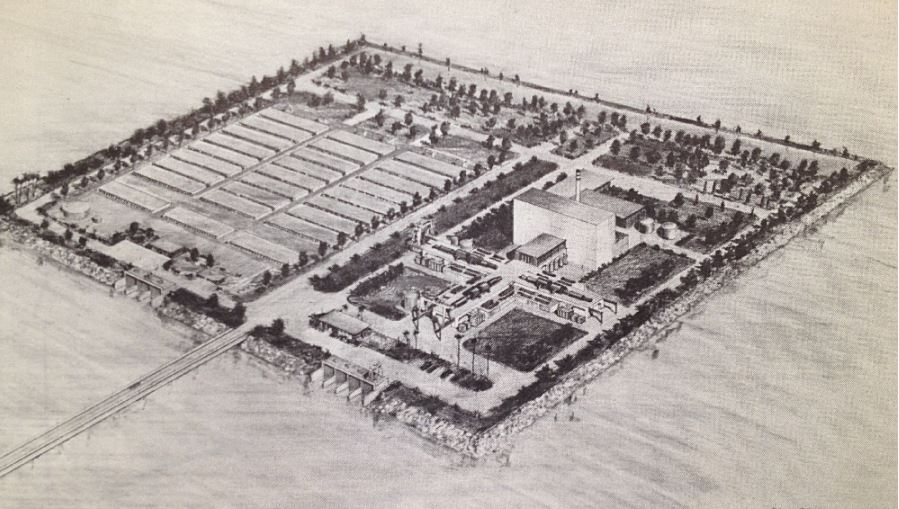
Altogether what one contemplates is the nuclear powered agro-industrial complex already alluded to by AEC Chairman Seaborg in his opening remarks. This summer we conducted at the Oak Ridge National Laboratory a study under the guidance of Professor E.A. Mason of the Massachusetts Institute of Technology to examine in some detail just what such a nuclear powered agro-industrial complex might look like.
Even this near term complex, based on energy from light water reactors, seems surprisingly attractive. In this complex, a variety of crops would be grown on 140,000 acres of irrigated desert. Ammonia, phosphorus from phosphate rock, caustic, chlorine, and salt would be manufactured.
The total investment (including a 2000 Mwe reactor and a 500 million gallons a day desalting plant) comes to about $900 million. The annual value of products produced is $330 million, of which $100 million are agricultural products.
The profit on the venture is computed to be $136 million per year, or 15% of the capital investment. I believe that the nuclear powered agro-industrial complex may well become an impressively powerful instrument for development. But it is idle to speak of the agro-industrial complex unless the main ingredient — the cheap and reliable reactor — is available.” 8
On June 13, hardly days after the six day’s war, AEC chairman Seaborg wrote a letter to Johnson’s Secretary of State Dean Rusk:
“The recent developments in the Middle East prompt me to recall to your attention certain projects which have been under consideration for this region for some time in the past. I am referring to the two dual-purpose nuclear desalting projects, one proposed for installation in Israel and the other proposed for installation in the United Arab Republic (Egypt and Syria were one single state between 1958 and 1961), which were the subject of your memorandum to the President of May 21, 1966 … It occurs to us that the possible usefulness of these projects in the overall settlement of the Middle East dispute may be rather significant …
As you know, both Israel and the UAR have attached considerable importance to their respective projects. The proposed Israeli project, in particular, always had the advantage of providing Israel with a source of water not subject to interruption by neighboring states and not dependent on the allocation of the already inadequate water resources of the Jordan Valley.
Once again, it seems to me that the recent events may well intensify the problem of water allocation in the area rather than ease it. One or more desalting plants would both add significantly to the total volume of water available to the region …
It is interesting to note that at the recent Water for Peace Conference in Washington, UAR and Israeli representatives participated in a collateral meeting of nations interested in nuclear desalting and reaffirmed the strong interest of their governments in these projects.”
In the same letter, Seaborg underlined that US assistance for a nuclear desalination program,
“could possibly be used to secure Israeli agreement to place its entire nuclear program, including the Dimona project, under IAEA safeguards. It seems to me that the recent events probably increase rather than decrease the danger that one or more of the Middle Eastern countries will feel, however mistakenly, that its best interest in the future would be served by the acquisition of nuclear weapons.”
On June 23, 1967, Lewis Strauss, who was a founding member and, starting 1953, the head of the AEC till 1958, pressured his friend and protector Eisenhower to speak up for nuclear desalination for peace in the Middle East, by giving him the following memo called “A proposal for our Time”:
“Attention to the debates in the United Nations since the end of May must convince the observer that an end to the trouble in the Near East is not in sight. The introduction of a new and dramatic element will be required to establish a climate in which peace can begin to be negotiated. The resources of diplomacy appear exhausted, and the « lie direct » has been exchanged so often that men can hardly be expected to reach agreement by rational discussion in the atmosphere which has been created.
“The two fundamental problems in the Near East are (a) water, and (b) displaced populations. It is these issues which have exacerbated international relationships in that area over the years, and they are not to be resolved by political or military measures. By a simple, bold, and imaginative step, it is in our power to solve both problems … Two of the installations would be located at appropriate points on the Mediterranean coast of Israel and a smaller one at the northern end of the Gulf of Aqaba in either Jordan or Israel, as the most suitable terrain may dictate….
“Were the President of the United States to electrify the world by such a proposal, as President Eisenhower did in his Atoms-for-Peace speech to the United Nations in 1953, it would be hailed and welcomed by millions who now can see no way out of the morass in which the powers are presently floundering with its threat of triggering more widespread war. The proposal might well be the beginning of a new life in the lands of the oldest civilizations.
“The proposal, of course, does not settle the boundary disputes and other acute issues now confronting the belligerents, but their settlement would be immensely accelerated and facilitated by the pressure from all sides to get ahead with such a project where delay would be counted in human lives and misery. It could be announced that no affirmative steps would be taken until negotiations at least began. In the atmosphere that would immediately follow such a proposal, the leaders of the Near Eastern countries would be invited to come together on the basis of the proposals. They have a common forum in the International Atomic Energy Agency.”
“The introduction of fresh water from all three plants into the arid and semi-arid areas would have the effect of opening to settlement many hundred square miles which heretofore have never supported human life (other than on a nomadic basis), and the controversy over the division of the Jordan River would become de minimis.
“The work of building the great plants, laying the pipe lines, constructing reservoirs, power lines, irrigation ditches, etc., will absorb the unskilled labor of thousands of displaced persons. When the plants are in operation, the labor force could be settled in irrigated areas under conditions far superior to any life that they have ever experienced.
“Solely as a measure of magnitude, it might be noted that the completed project will represent substantially less than one year’s expenditure on the moon program. It will pay for itself and return income in perpetuity, retiring the borrowings incurred and rewarding the governments and individuals with vision enough to have subscribed to it initially.
“Cooperation of the Arab and Israeli governments will be necessary in order to agree upon a modus vivendi for allocating water and power, and it will be apparent that any government which simply declined to discuss or participate in such a cooperative arrangement would have to answer to its citizens sooner or later.” 9
Lewis Strauss

Lewis Strauss, started his career, not in nuclear science, but working as an investment banker at the Wall Street investment bank Kuhn, Loeb & Co. On March 5, 1923, he married Alice Hanauer, the daughter of Jerome J. Hanauer, who was one of the Kuhn Loeb partners.
But Strauss was also a philanthropist financing and leading several Jewish organizations. In 1933 he was a member of the executive committee of the American Jewish Committee. He was active in the Jewish Agricultural Society, for whom by 1941 he was honorary president. By 1938 he was also active in the Palestine Development Council, the Baron de Hirsch Fund, and the Union of American Hebrew Congregations.
However, he was not a Zionist and opposed the establishment of a Jewish state in Mandatory Palestine. He did not view Jews as belonging to a nation or a race; he considered himself an American of Jewish religion, and consequently he advocated for the rights of Jews to live as equal and integral citizens of the nations in which they resided.
Politically, Strauss got befriended and worked directly with President Herbert Hoover and felt irritated by FDR.
Edmond de Rothschild

One month after Strauss memo to Eisenhower, on July 18, US Ambassador Bruce reported the fact that French-Swiss banker Edmond Adolphe de Rothschild, in two letters to the London Times, had advocated for three nuclear desalting plants for Israel, Jordan, and the Gaza Strip to assist in the resettlement of more than 200,000 refugees.
This provoked comments and questions in the House of Commons, which generally approved the idea or at least further exploration of it.
British Prime Minister Wilson was convinced of the technical-economic feasibility of the plan, but the Foreign Office was concerned about the cost.
According to Embassy officials in London: “Apart from the obvious political difficulties, it was mainly a question of a very large amount of cheap money, which the UK did not have available.”
However, Edmond de Rothschild was apparently willing to put up 1 million pounds sterling of his own money. 10
Humanitarian and/or Business Plan?
Both Strauss and Rothschild shared the same idea, that of forming a corporation with a charter resembling that of COMSAT, a public, federally funded corporation created in 1962 intended to develop a commercial international satellite communication system. Although Comsat was government regulated, it was equally owned by some major communications corporations and independent investors.
The new corporation, wrote Strauss, should be created,
“with the Government subscribing to half of the stock, the balance to be offered for public subscription in the security markets of the world. The amount thus to be raised, say $200,000,000, would be used to begin construction of the first of three large nuclear plants for the dual purpose of producing kilowatts of electrical energy and desalting sea water, with emphasis on the latter purpose.”
“Private capital both in the United States and Great Britain would certainly respond to the challenge of such an enterprise on the initiative of the Government,” concluded Strauss.
Strauss and Eisenhower

Strauss was a staunch anti-communist and successfully lobbied Truman, who publicly announced the decision, as demanded by Strauss, to develop the hydrogen bomb on January 31, 1950. Less than three years later, the US detonated the world’s first H-bomb, only to have the Soviets follow suit 10 months later. Strauss’ determination to develop the hydrogen bomb was doggedly opposed by physicist J. Robert Oppenheimer, the chairman of the AEC’s general advisory committee who led the Manhattan Project in Los Alamos, New Mexico. Fearing the hydrogen bomb would only accelerate a dangerous Cold War arms race, Oppenheimer had argued for more openness about the size and capabilities of America’s nuclear arsenal, which Strauss thought would only benefit the Soviets.
After leaving the AEC in 1950, Strauss re-entered government when newly elected President Dwight D. Eisenhower appointed him as an atomic energy adviser in February 1953. Strauss, who had been a major donor to Eisenhower’s presidential campaign, wielded considerable power as all federal agencies were required to clear their atomic-related activities with him. Months later, Eisenhower asked Strauss to chair the AEC. Strauss agreed on one condition: that Oppenheimer no longer serve as a consultant to the commission…
Strauss’ plan for desalination became known as the “Strauss-Eisenhower plan” because Eisenhower, whose major speech Atoms for Peace at the UNGA in 1953 had been widely welcomed by the American public, published an article, largely inspired by the Strauss 1967 memo and edited by editor in chief of Reader’s Digest Ben Hibbs in that magazine’s June 1968 edition.
The full text of Eisenhower’s article was introduced as early on May 16 in the Congressional record (p. 13756), by Senator James G. Fulton.
Noteworthy, the fact that Robert F. Kennedy, who saved the world from nuclear extinction by using his back channels with Russian officials, was assassinated on June 8 of the same year.
In the overall inspiring article in his Reader’s Digest, former president Eisenhower, visibly convinced by Admiral Lewis Strauss and his banker’s friends such as Edmond de Rothschild who thought it was good business, wrote that:
“There is every reason to suppose that it could be a successful, self-sustaining business enterprise, whose revenues would derive from the sale of it products – water and electricity – to the users. Our government would make an initial investment in some of the corporation’s stock, and the rest would be sold to private investors in the security markets of the world. Additional money would be raised through the international marketing of convertible debentures. We are assured by international bankers that the financial world, under normal conditions, would welcome such an investment opportunity.”
However, Eisenhower made an extremely crucial point, that is very relevant for today:
”Most of the professional diplomats seem to think that we must have peace in the Middle East before the plan can be implemented. I contend that the reverse is true: the proposal itself is a way to peace.”
Unfortunately, in his Reader’s Digest article, the former president, or the editor, or by common decision of both, left out a key passage of Strauss earlier (June 1967) proposal, a passage implicitly proposing to make the Middle East desalting proposal the cornerstone for ending the Cold War!
Strauss, interestingly enough, had changed the axioms of his thinking, because the view he presented in 1967 (start some sort of peaceful cooperation with the USSR) was miles away from his views in 1950 (contain the Soviets at all cost). That said key passage reads as follows:
“Design and construction contracts would be let on bids in the several countries which have had experience in building large nuclear reactors, i.e., the United States, the United Kingdom, France, and the USSR.”
Those days Political parties
While today’s US party platforms are utter lunacy, in 1968, when Nixon was running against Humphrey and Wallace, voters could choose between two parties favoring nuclear desalination!
The Democratic party platform:
“To maintain our leadership in the application of energy, we will push forward with research and development to assure a balanced program for the supply of energy for electric power, both public and private. This effort should go hand in hand with development of « breeder » reactors and large-scale nuclear desalting plants that can provide pure water economically from the sea for domestic use and agricultural and industrial development in arid regions, and with broadened medical and biological applications of atomic energy. In addition to the physical sciences, the social sciences will be encouraged and assisted to identify and deal with the problem areas of society.
“… Lasting peace in the Middle East depends upon agreed and secured frontiers, respect for the territorial integrity of all states, the guaranteed right of innocent passage through all international waterways, a humane resettlement of the Arab refugees, and the establishment of a non-provocative military balance. To achieve these objectives, we support negotiations among the concerned parties. We strongly support efforts to achieve an agreement among states in the area and those states supplying arms to limit the flow of military equipment to the Middle East. We support efforts to raise the living standards throughout the area, including desalinization and regional irrigation projects which cut across state frontiers.” 11
The Republican Party platform:
“We support efforts to increase our total fresh water supply by further research in weather modification, and in better methods of desalination of salt and brackish waters.”
And on the Middle East, it said:
“To replace the ancient rivalries of this region with new hope and opportunity, we vigorously support a well conceived plan of regional development, including the bold nuclear desalination and irrigation proposal of former President Eisenhower.” 12(*10)
Conclusion
In one way or another, Middle East Peace, based on the sharing of water and energy obtained by the most advanced technologies (in terms of energy density), were on the agenda those days, and sometimes even conceptualized as the cornerstone of a potential new international architecture of security and mutual development ending the geopolitics of the Cold War.
Lyndon LaRouche’s proposals in 1975 and his Oasis plan currently proposed and promoted by the international Schiller Institute want to do exactly that. 13

LaRouche’s « Blue Peace » Oasis plan, to be put on the table of diplomatic negotiations as the « spine » of a durable peace agreement », includes:
- Israel’s relinquishment of exclusive control over water resources in favor of a fair resource-sharing agreement between all the countries in the region;
- The reconstruction and economic development of the Gaza Strip, including the Yasser Arafat International Airport (inaugurated in 1998 and bulldozered by Israeli in 2002), a major seaport backed up by a hinterland equipped with industrial and agricultural infrastructure.
- A floating, underwater or off-shore desalination plant will be stationed in front of Gaza.
- The construction of a fast rail network reconnecting Palestine (including Gaza) and Israel to its neighbors;
- The construction, for less than 20 billion US dollars of both the Red-Dead and the Med-Dead water conveyance system composed of tunnels, pipelines, water galeries, pumping stations, hydro-power units and nuclear powered desalination plants.
- Salted sea water, arriving at the Dead Sea, before desalination, will « fall » through a 400 meter deep shaft and generate hydro-electricity.
- Following desalination, the fresh water will go to Jordan, Palestine and Israel; the brine will refill and save the Dead Sea.
- The nuclear powered desalination plant will produce heat and electricity with « hybrid desalination » combining evaporation and Reverse Osmosis (RO) ;
- The industrial heat of the high temperature reactors (HTR) will also be tapped for industrial and agricultural purposes;
- The reservoirs of the water conveyance systems will also function as a Pumped Storage Power Plant (PSPP), essential for regulating the region’s power grids;
- Part of the seawater going through the Med-Dead Water conveyance system will be desalinated in Beersheba, the « capital of the Negev » whose population, with new fresh water supplies, can be doubled.
- New cities and « development corridors » will grow around the new water conveyance systems.
- Israel’s Dimona nuclear center and power plant (currently a military reactor and medical nuclear waste treatment center) can form the basis to create a civilian nuclear program and contribute to the construction of nuclear desalination plants. Jordan can contribute to the program with it vast reserves of thorium and uranium.
- US and Israeli plans to prepare the housing of 500,000/1 million people in the Negev exist but should be entirely reconfigured in terms of both scope and intent. They cannot be a mere extension of exclusively Jewish settlements, but should offer the opportunity to all Israeli citizens, in peaceful cooperation with the Bedouins who live there, the Palestinians and others, to roll back a common enemy: the desert.
- The policy of illegal settlements in the West Bank shall be halted. Settlers will be encouraged (through taxation, etc.) to relocate to the Negev, where they, in a shared effort with the Bedouins, Palestinians and others, can take up productive jobs and make the desert bloom (62% of Israeli territory).
PS: The Oasis Plan plan aims to bring peace to all through mutual development. It has nothing to do with Netanyahu’s Ben-Gurion canal project, a megalomaniac plan for a navigation canal connecting the Red Sea with the Mediterranean aimed to compete with the Suez Canal.
NOTES:
- The British Government was reported greatly concerned with the Russian arms offers; Prime Minister Eden regarded the offer to Egypt as the most “sinister” development in the East-West conflict since the Soviets took over Czechoslovakia. The British Government informed the United States in October 1955 it regarded a Russian undertaking to construct and finance the High Aswan Dam following the sale of Czech arms to Egypt would be a very serious blow to Western prestige and influence in the Middle East, providing the Russians with a means of exercising a dominating influence politically and economically in this area. ↩︎
- Myrl Kennedy Bailey, 1966 Thesis, « THE POLICIES OF- JOHN FOSTER DULLES RELATIVE TO THE SUEZ CRISIS OF 1956. »
↩︎ - Karel Vereycken, Israel-Palestine, Time to Make Water a Weapon for Peace, artkarel.com, March 2024. ↩︎
- Public Papers of the Presidents of the United States: Lyndon B. Johnson, 1967, Book I, pages 555-558. ↩︎
- Department of State, SCI Files: Lot 69 D 217, The Department during the Administration of Lyndon B. Johnson, November 1963-January 1969, Vol. XI, Science and Technology. The proceedings of the conference were published as the “International Conference on Water for Peace,” May 23-31, 1967. ↩︎
- Letter from Harrar to Weinberg. ↩︎
- Letter from Weinberg to Bell. ↩︎
- https://www.iaea.org/sites/default/files/publications/magazines/bulletin/bull9-6/09604701121.pdf ↩︎
- https://history.state.gov/historicaldocuments/frus1964-68v34/d166 ↩︎
- Airgram A-222 from London, July 18; National Archives and Records Administration, RG 59, Records of the Department of State, Central Files, 1967-69, E 11-3 NEAR EAST. ↩︎
- https://www.presidency.ucsb.edu/documents/1968-democratic-party-platform ↩︎
- https://www.presidency.ucsb.edu/documents/republican-party-platform-1968 ↩︎
- See note 1. ↩︎
Israel-Palestine: Time to Make Water a Weapon for Peace

« If we solve all the problems in the Middle East,
but not the problem of sharing water, our region will explode.
Peace will not be possible »
(Yitzhak Rabin, former Israeli Prime Minister, 1992).
« You only make peace with your enemies. »
(Yitzhak Rabin.)
Contents:
Introduction
1. Geography of the Middle East
2. Rainfall and Water resources
3. Hydrography of the Jordan basin
A. Source
B. Tributaries
C. Lake of Tiberias
D. Yarmouk river
4. Water sources for Israel-Palestine
A. Surface water
B. Groundwater
C. Desalination
D. Reuse of Waste water
5. Water Infrastructure Projects
A. National Water Carrier (NWC)
B. Johnston Plan
C. Ghor Canal
D. Med – Dead Sea aqueduct
E. Red Sea – Dead Sea Water Conveyance
F. Turkish projects
G. Hidden defects and non-application of the Oslo agreements
H. Ben-Gurion Canal
I. Oasis Plan
J. Alvin Weinberg, Yitzhak Rabin and Lyndon LaRouche
Introduction
This article provides readers with the keys. To understand the history of the water wars that continue to ravage the Middle East, it is essential to understand the geological, hydrographical, geographical and political issues at stake. In the second part, we examine the various options for developing water resources as part of a strategy to overcome the crisis. We will deal with the gas issue, another subject of potential conflict or cooperation, in a later article.
1. Geography
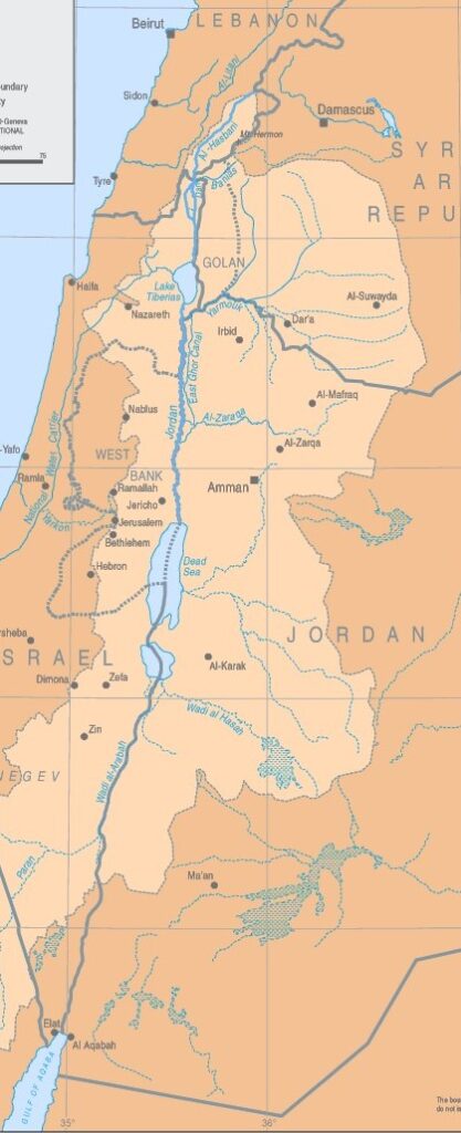
The Jordan River basin is shared by four countries: Lebanon, Syria, Jordan and Israel, plus the Palestinian territories of the West Bank and Gaza.
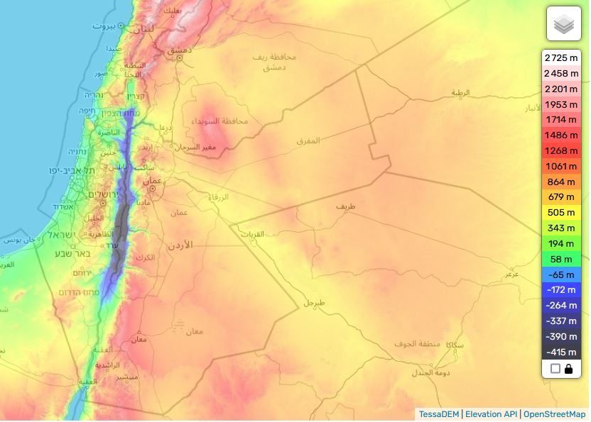
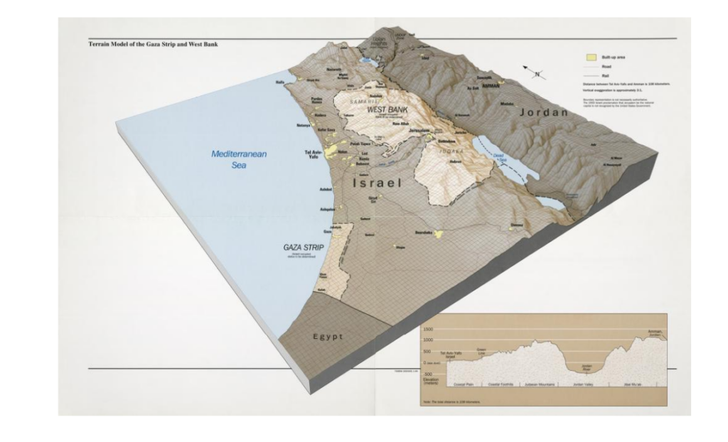
Situated in the hollow of a tectonic depression on the great fault that runs from Aqaba to Turkey, the Jordan Valley is one of the lowest-lying basins in the world, flowing into the Dead Sea at an altitude of 421 meters below sea level.
See interactive topographic map.
Added to this is the fact that this is an endorheic basin, i.e. a river that flows neither into the sea nor the ocean. As in the Aral Sea basin in Central Asia, this means that any water drawn or diverted upstream reduces the level of its ultimate receptacle, the Dead Sea (see below), and can even potentially make it disappear.
While remaining a fundamental artery for the entire region, the Jordan River has a number of drawbacks: its course is not navigable, its flow remains low and its waters, which are highly saline, are polluted.
As one of the key factors in the « Water, Energy, Food nexus » – three factors whose interdependence is such that we can’t deal with one without dealing with the other two – water resource management remains a key issue, and holds a primordial place for any future shared between Israel and its Arab neighbors. To grow food, one needs water. But to desalinate sea water, Israel spends 10 % of its electricity generated by consuming gas and oil.
2. Rainfall and water resources
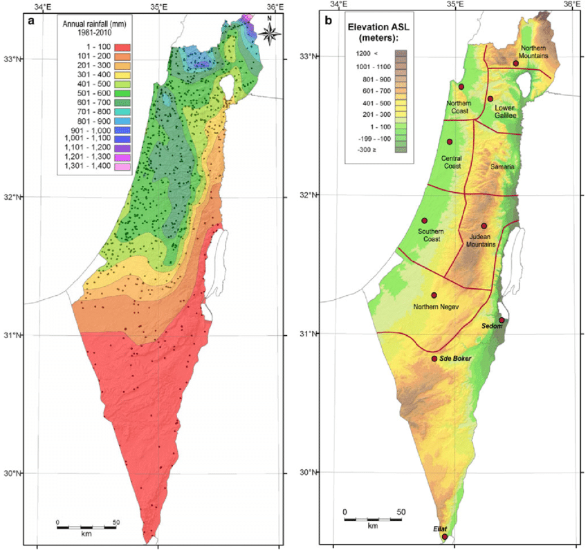
The Middle East forms a long, arid strip, only accidentally interrupted by areas of abundant rainfall (around 500-700 mm/year), such as the mountains of Lebanon, Palestine and Yemen.
Geographically, much of the Middle East lies south of the isohyet (imaginary line connecting points of equal rainfall) indicating 300 mm/year.
However, precipitation has only a limited effect due to its seasonality (October-February).
As a result, river flow and flooding are irregular throughout the year, as well as between years. The same applies to groundwater recharge.
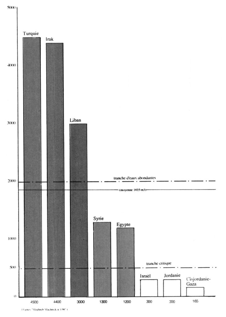
On a state-by-state basis, total water resources are very unevenly distributed in the region:
—Turkey and Iraq have over 4,000 cubic meters per person per year, and Lebanon around 3000 m³/person/year, which is above the regional average (1,800 m³/person/year).
—Syria and Egypt have around 1200 m³/person/year, one third lower.
On the other hand, some countries are below the critical 500 m³/year/capita bracket:
—Israel and Jordan have 300 m³/year/capita, and the Palestinian Territories (West Bank-Gaza) less than 200 m³/year/capita. They are in what the World Health Organization (WHO) calls a situation of « water stress ».
The Middle East enjoys plenty of water on a regional scale, but has many areas in chronic shortage, on a local scale.
3. Hydrography of the Jordan basin
A. Source
360 km long, the Jordan River rises from water flowing down the slopes of Jabal el-Sheikh (Mount Hermon) in southern Lebanon on the border with Syria.
B. Tributaries
Once over the Israeli border, three tributaries join the Jordan about 6 kilometers upstream from the former Lake Hula (now reclaimed):
1. The Hasbani, with a flow of 140 million cubic meters (MCM) per year, rises in Lebanon, a country it crosses over 21 kilometers. The upper reaches of the Hasbani vary greatly with the seasons, while the lower reaches are more regular.
2. The Banias, currently under Israeli control and 30 kilometers long, has an annual flow close to that of the Hasbani (140 MCM). It rises in Syria in the Golan Heights, and flows into Israel for around 12 kilometers before emptying into the Upper Jordan.
3. The Nahr Leddan (or Dan) forms in Israel when the waters of the Golan Heights come together. Although restricted, its course remains stable and its annual flow is greater than that of the other two tributaries of the Upper Jordan, exceeding 250 MCM per year.
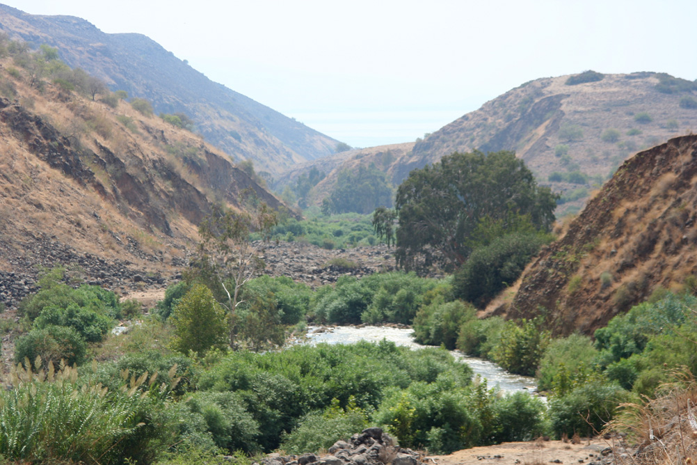
C. Lake Tiberias or Kinneret (aka Sea of Galilee)
The Jordan then flows through 17 km of narrow gorges to reach Lake Tiberias, where the salinity is high, especially as the freshwater streams flowing into it have been diverted. Lake Tiberias, however, receives water from the many small streams running through the Golan Heights.
D. Yarmouk River
Next, the Jordan meets the Yarmouk River (bringing in water from Syria), then meanders for 320 km (109 km as the crow flies) to reach the Dead Sea. These 320 km are occupied by a humid plain (the humid zor), with subtropical vegetation, dominated on both sides (West Bank and Jordanian) by dry, gullied terraces.
4. Water sources for Israel
The Hebrew state has four main sources of water supply:
A. Surface Water
Israel benefits first and foremost from the freshwater reserves of Lake Tiberias in Galilee, in the north of the country. Crossed by the Jordan River, this small inland sea accounts for 25% of Israel’s water needs. The annexation of the Golan Heights and the occupation of southern Lebanon have made this source of water a sanctuary.
B. Groundwater
In addition to surface water (lakes and rivers), the country can rely on its coastal aquifers, from Haifa to Ashkelon.
Located between Israel and the occupied West Bank, the main aquifer, the Yarkon-Taninim mountain aquifer, has a capacity of 350 MCM per year. In the northeast and east of the West Bank are two other aquifers with capacities of 140 and 120 MCM per year respectively.
C. Seawater desalination

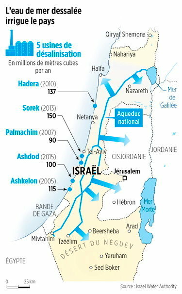
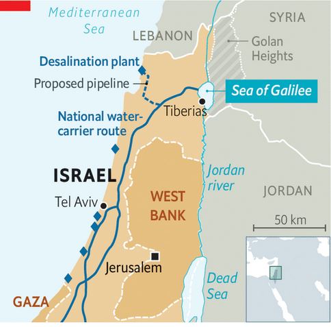
Five desalination plants built along the country’s coastline — in Ashkelon (2005), Palmachin (2007), Hadera (2010), Sorek (2013) and Ashdod (2015) — currently operate and two more are under construction. Collectively, these plants are projected to account for 85-90 per cent of Israel’s annual water consumption, marking a remarkable turnaround.
The Sorek desalination plant, located about 15 km south of Tel Aviv, became operational in October 2013 with a seawater treatment capacity of 624,000m³/day, which makes it world’s biggest seawater desalination plant. The desalination facility uses seawater reverse osmosis (SWRO) process providing water to Israel’s National Water Carrier system (NWC, see below). A dozen more units of this type are considered for construction.
Israel, which has been facing severe droughts since 2013, even began pumping desalinated seawater from the Mediterranean into Lake Tiberias, a unique performance worldwide. While Israel faced water scarcity two decades ago, it now exports water to its neighbors (not too much to Palestine). Israel currently supplies Jordan with 100 MCM and fulfills 20 % of Jordan’s water needs.
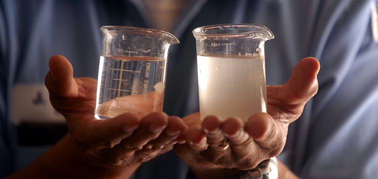
From 100 liters of seawater, 52 liters of drinking water and 48 liters of brine (brackish water) can be obtained. Although highly efficient and useful, desalination technology has still to be perfected, as it currently discharges brine into the sea, disrupting the marine ecosystem. To reduce this pollution and transform it into solid waste, we need to increase treatment and therefore energy consumption.
D. Wastewater
The country prides itself on reusing between 80% and 90% of its wastewater for agriculture. Treated wastewater used for irrigation is known as effluent. Israel’s effluent utilization rate is one of the highest in the world. Reclamation is carried out by 87 large wastewater treatment plants (WWTPs) that supply over 660 MCM per year. This represents around 50% of total water demand for agriculture and around 25% of the country’s total water demand. Israel aims to more than double the amount of effluent produced for the agricultural sector by 2050.
5. Water infrastructure projects

For Israel, acquiring water resources in a desert region, through technology, military conquest and/or diplomacy, was from the outset an imperative to meet the needs of a rapidly growing population and, in the eyes of the rest of the world, a demonstration of its sovereign power and its superiority.
This symbolism is particularly evident in the figure of the father of the Hebrew state, David Ben-Gurion (1886-1973), whose aim was to make the Negev desert in the south of the country « blossom ».
In his book Southwards (1956), Ben Gourion described his ambition:
« It is absolutely vital for the State of Israel, both for economic and security reasons, to go south: we must direct the water and rain to there, send the young pioneers there […] as well as the bulk of our budget resources to development. »
A. National Water Carrier of Israel (NWC)
OBJECTIVE: provide fresh water for Israel’s agriculture and growing population.
From 1959 to 1964, the Israelis built the National Water Carrier of Israel (NWC), the largest water project in Israel to date.
The first ideas appeared in Theodor Herzl‘s book Altneuland (1902), in which he spoke of using the springs of the Jordan for irrigation purposes and channeling seawater to generate electricity from the Mediterranean Sea near Haifa through the Beit She’an and Jordan valleys to a canal running parallel to the Jordan and Dead Sea.
In 1919, Chaïm Waizmann, leader of the World Zionist Organization, declared: « The whole economic future of Palestine depends on its water supply ».
However, he advocated incorporating the Litani Valley (in today’s southern Lebanon) into the Palestinian state.
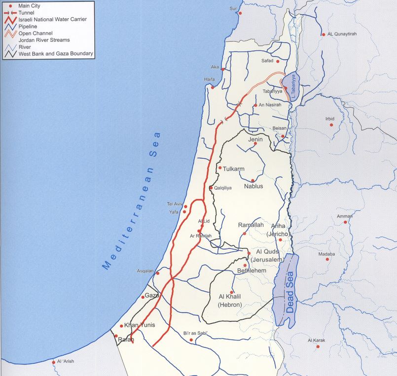
The NWC project was conceived as early as 1937, although detailed planning began after the recognition of Israel in 1948. In practice, the natural flow of the Jordan River is prevented by the construction of a dam, built south of Lake Tiberias. From there, water is diverted to the NWC, a 130 km-long system combining giant pipes, open channels, tunnels, reservoirs and large-scale pumping stations. The aim is to transfer water from Lake Tiberias to the densely populated center and the arid south, including the Negev desert.
When it was inaugurated in 1964, 80% of its water was allocated to agriculture and 20% to drinking water. By 1990, the NWC supplied half of Israel’s drinking water. With the addition of water from seawater desalination plants, it now supplies Tel Aviv, a city of 3.5 million inhabitants, Jerusalem (1 million inhabitants) and (outside wartime) Gaza and the occupied territories of the West Bank.
Since 1948, the area of irrigated farmland has increased from 30,000 to 186,000 hectares. Thanks to micro-irrigation (drip irrigation, including subsurface irrigation), Israeli agricultural production increased by 26% between 1999 and 2009, although the number of farmers fell from 23,500 to 17,000.
The Water War
In launching its NWC, Israel went it alone, while for the rest of the world, it was clear that diverting the waters of the Jordan River would give rise to sharp tensions with neighboring countries, particularly with Jordan and Syria, not to mention the Palestinians who have been largely excluded from the project’s economic benefits.
As early as 1953, Israel began the unilateral draining of Lake Hula (or Huleh), north of Lake Tiberias, leading to skirmishes with Syria.
In 1959, Israel kickstarted the NWC. The project was initially interrupted by a halt in American funding, as the Americans did not want to see violence escalate in the context of the Cold War.
It should be noted that, following the Suez crisis of 1956, the Soviet Union established itself in Syria as the protecting power of Arab countries against the « Israeli threat ». As part of the deployment of its naval presence in the Mediterranean, it obtained facilities for its fleet at Latakia in Syria.
However, Israel managed to quietly resume and continue the work on the NWC. Filling the system by pumping of Lake Tiberias began in June 1964 in utmost secrecy. When the Arab countries learned of this, their anger was great. In November 1964, the Syrian army fired on Israeli patrols around the NWC pumping station, provoking Israeli counter-attacks. In January 1965, the NWC was the target of the first attack by the Fatah (organization fighting for the liberation of Palestine) led by Yasser Arafat.
The Arab states finally recognized that they would never be able to stop the project through direct military action.
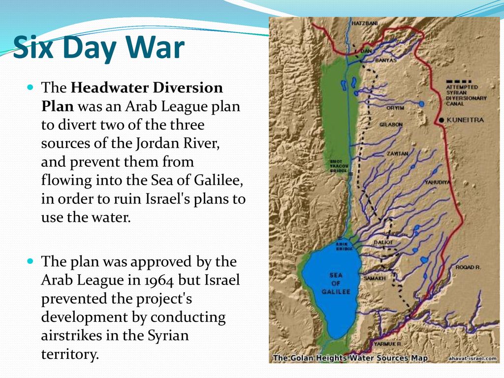
They therefore adopted a plan, the Headwater Diversion Plan immediately implemented in 1965, to divert water upstream from the tributaries of the Jordan River into the Yarmouk River (in Syria). The project was technically complicated and costly, but if successful would have diverted 35% of the water Israel intended to withdraw from the upper Jordan…
Israel declared that it considered this deviation of the water as an infringement of its sovereign rights. Relations degenerated completely and border clashes followed, with Syrian forces firing on Israeli army farmers and patrols. In July 1966, the Israeli air force bombed a concentration of earth-moving equipment and shot down a Syrian MiG-21. The Arab states abandoned their counter plan, but the conflict continued along the Israel-Syria border, including an Israeli air attack on Syrian territory in April 1967.
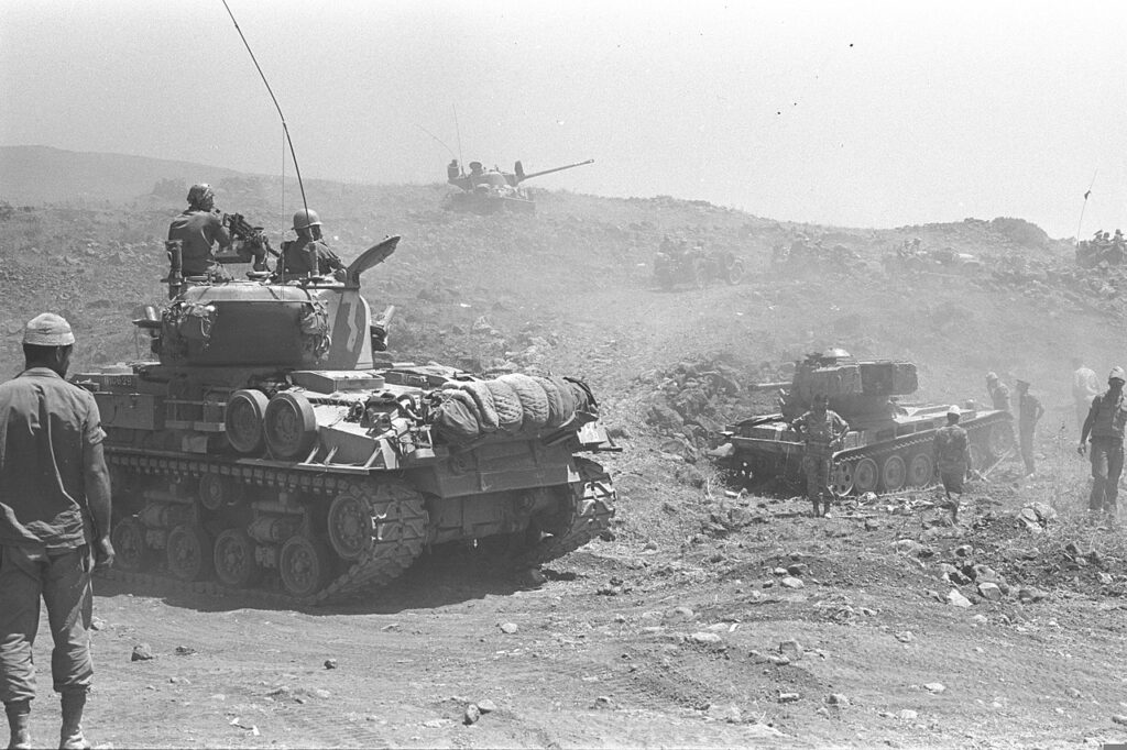
For many analysts, this was a prelude to the Six-Day War in 1967, when Israel occupied the Golan Heights to protect its water supply. The Six-Day War profoundly altered the geopolitical situation in the basin, with Israel now occupying not only the Gaza Strip and Sinai, but also the West Bank and the Golan Heights.
As French researcher Hervé Amiot explains:
« Israel went from being a downstream country to an upstream one, enabling it to gain control of vast resources. Israel now controlled 20% of the northern bank of the Yarmouk and occupied the Golan Heights, controlling all the small rivers flowing into Lake Tiberias. What’s more, total occupation of the West Bank gives them control over the important water tables ».
In fact, as early as 1955, between a quarter and a third of the water came from the groundwater in the south-western part of the West Bank. Today, the West Bank aquifers supply Israel with 475 million m³ of water, i.e. 25-30% of the country’s water consumption (and 50% of its drinking water).
Two months after the seizure of the occupied territories, Israel issued “Military Decree 92”, transferring authority over all water resources in the occupied territories to the Israeli army and conferring « absolute power to control all water-related matters to the Water Resources Officer, appointed by the Israeli courts ». This decree revoked all drilling licenses issued by the Jordanian government and designated the Jordan region a military zone, thus depriving Palestinians of all access to water while granting Israel total control over water resources, including those used to support its settlement projects.
Today, returning the Golan to Syria and recognizing the sovereignty of the Palestinian Authority over the West Bank seems impossible for Israel, given the Hebrew state’s increasing dependence on the water resources of these occupied territories. The exploitation of these resources will therefore continue, despite Article 55 of the Regulations of the IVth Hague Convention, which stipulates that an occupying power does not become the owner of water resources and cannot exploit them for the needs of its civilians…
B. Johnston Plan
OBJECTIVE: In the context of the Cold War, counter Nasser’s growing influence in the region. Offer regional stability by building dams and canals allowing a just sharing of water resources and providing water and energy for both Israel and Arab states welcoming « unfortunate » Palestinian refugees.
One might think that the United States tried very early on to prevent the situation from degenerating in such a predictable way. They tried to take into account Israel’s legitimate interest in securing access to water, the absolute key to its survival and development, while at the same time offering neighboring countries (Jordan, Syria and Lebanon) sufficient resources to accommodate the millions of Palestinians exiled from their homes following the Nakba.
Faced with the risk of conflict, as early as 1953 – years before Israel launched its NWC plan – the American government proposed its mediation to resolve disputes over the Jordan basin. The result was the « Jordan Valley Unified Water Plan » (known as the « Johnston Plan »), named after Eric Allen Johnston, president of the United States Chamber of Commerce and US President Dwight Eisenhower‘s water envoy.
More concretely, “The Unified Development of the Water Resources of the Jordan Valley Region,” was prepared at the request of the United Nations Relief and Works Agency for Palestine Refugees under the direction of the Tennessee Valley Authority.
On Oct. 13, 1953, Eisenhower’s Secretary of State John Foster Dulles, in a top secret letter instructed Johnston what his mission was all about and on Oct. 16, in a public statement Eisenhower explained:
« One of the major causes of disquiet in the Near East is the fact that some hundreds of thousands of Arab refugees are living without adequate means of support in the Arab states. The material wants of these people have been cared for through the United Nations Relief and Works Agency (UNRWA) … It has been evident from the start, however, that every effort must be made by the countries concerned, with the help of the international community, to find a means of giving these unfortunate people an opportunity to regain personal self-sufficiency.
« One of the major purposes of Mr. Johnston’s mission will be to undertake discussions with certain of the Arab states and Israel, looking to the mutual development of the water resources of the Jordan River Valley on a regional basis for the benefit of all the people of the area. …
« Such a regional approach holds a promise of extensive economic improvement in the countries concerned through the development of much needed irrigation and hydroelectric power and through the creation of an economic base on the land for a substantial proportion of the Arab refugees. It is my conviction that acceptance of a comprehensive plan for the development of the Jordan Valley would contribute greatly to stability in the Near East and to general economic progress of the region.«
This plan established the transboundary nature of the Jordan basin and proposed an equitable sharing of the resource, giving 52% of the water to Jordan, 31% to Israel, 10% to Syria and 3% to Lebanon.
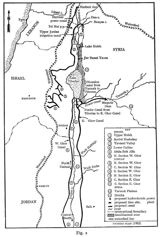
The plan, just as the Tennessee Valley Authority during FDR’s New Deal, was essentially based on building dams for irrigation and hydropower. The water was there and correctly managed, sufficient for the needs of the population at that time. Its main features were:
- a dam on the Hasbani River to provide power and irrigate the Galilee area;
- dams on the Dan and Banias Rivers to irrigate Galilee;
- drainage of the Huleh swamps;
- a dam at Maqarin on the Yarmouk River for water storage (capacity of 175 million m³) and power generation;
- a small dam at Addassiyah on the Yarmouk to divert its water toward both the Lake Tiberias and south along the eastern Ghor;
- a small dam at the outlet of Lake Tiberias to increase its storage capacity;
- gravity-flow canals along the east and west sides of the Jordan valley to irrigate the area between the Yarmouk’s confluence with the Jordan and the Dead Sea;
- control works and canals to utilize perennial flows from the wadis that the canals cross.
See details of the Johnston plan in this comprehensive article.
The project was validated by the technical committees of Israel and the Arab League, and did not require Israel to abandon its ambition to green the Negev desert. Unfortunately, however, the presentation of the plan to the Knesset in July 1955 did not result in a vote.
The Arab Committee approved the plan in September 1955 and forwarded it to the Council of the Arab League for final approval. Tragically, this institution also chose not to ratify it on October 11, because of its opposition to an act implying an implicit act of recognition of Israel that would prevent the return of the Palestinian refugees to their home… The mistake here was to isolate the water issue from a broader agreement on peace and justice as the foundation of mutual development.
Then, after the Suez Canal crisis in 1956, the Arab countries, with the exception of Jordan, hardened their stance towards Israel considerably, and henceforth opposed the Johnston plan head-on, arguing that it would amplify the threat posed by that country by enabling it to strengthen its economy. They also claim that increasing Israel’s water resources could only increase Jewish migration to the Hebrew state, thereby reducing the possibility of the return of Palestinian refugees from the 1948 war…
History cannot be rewritten, but the adoption of the Johnston Plan could well have prevented conflicts, such as that of 1967, which cost the lives of 15,000 Egyptians, 6,000 Jordanians, 2,500 Syrians and at least 1,000 Israelis.
C. Jordan’s response: the Ghor irrigation Canal
OBJECTIVE: construct the Jordanian section of the Johnston Plan to have water for irrigation and the capital of Jordan.

At almost the same time as Israel was completing its NWC, Jordan was digging the East Ghor irrigation canal between 1955 and 1964, starting at the confluence of the Yarmouk and Jordan rivers and running parallel to the latter all the way to the Dead Sea on Jordanian territory.
Originally, this was part of a larger project – the « Greater Yarmouk » project – which included two storage dams on the Yarmouk and a future “Western Ghor Canal” on the west bank of the Jordan. The latter was never built, as Israel took the West Bank from Jordan in the 1967 Six-Day War.
In effect, by diverting the waters of the Yarmouk to fill up its own canal, Jordan secured water for its capital Amman and its agriculture, but of course, contributed reducing the waters of the Jordan River.
In Jordan, the Jordan’s river watershed is a region of vital importance to the country. It is home to 83% of the population, the main industries and 80% of irrigated agriculture. It is also home to 80% of the country’s total water resources.
Overall, the Hashemite kingdom is one of the world’s most water-poor countries, with 92% of its territory desert. While Israel has 276 m³ of natural freshwater available per capita per year, Jordan has just 179 m³, more than half of which comes from groundwater.
The UN considers that a country with less than 500 m³ of freshwater per capita per year suffers from « absolute water stress ». Added to this is the fact that since the start of the Syrian civil war, Jordan has welcomed nearly 1.4 million refugees onto its soil, in addition to its 10 million inhabitants.
The East Ghor Canal was designed in 1957 and built between 1959 and 1961 competing with Israel’s NWC. In 1966, the upstream section as far as Wadi Zarqa was completed. The canal was then 70 km long and was extended three times between 1969 and 1987.
The United States, through the U.S. Agency for International Development (USAID), financed the initial phase of the project, after obtaining explicit assurances from the Jordanian government that Jordan would not withdraw more water from the Yarmouk than had been allocated to it under the Johnston Plan. They were also involved in the subsequent phases.
Waterworks in the region are often named after great political figures. The East Ghor Canal was named « King Abdallah Canal (KAC) » by Abdalla II after his great-grandfather, the founder of Jordan. At the time of the peace treaty with Israel in 1994, the two countries shared the flow of the Jordan, and Jordan agreed to sell its water from Lake Tiberias.
D. Mediterranean – Dead Sea Aqueduct
OBJECTIVE: generate hydro-electricity and make Israel independant from Arab oil and gas supplies.
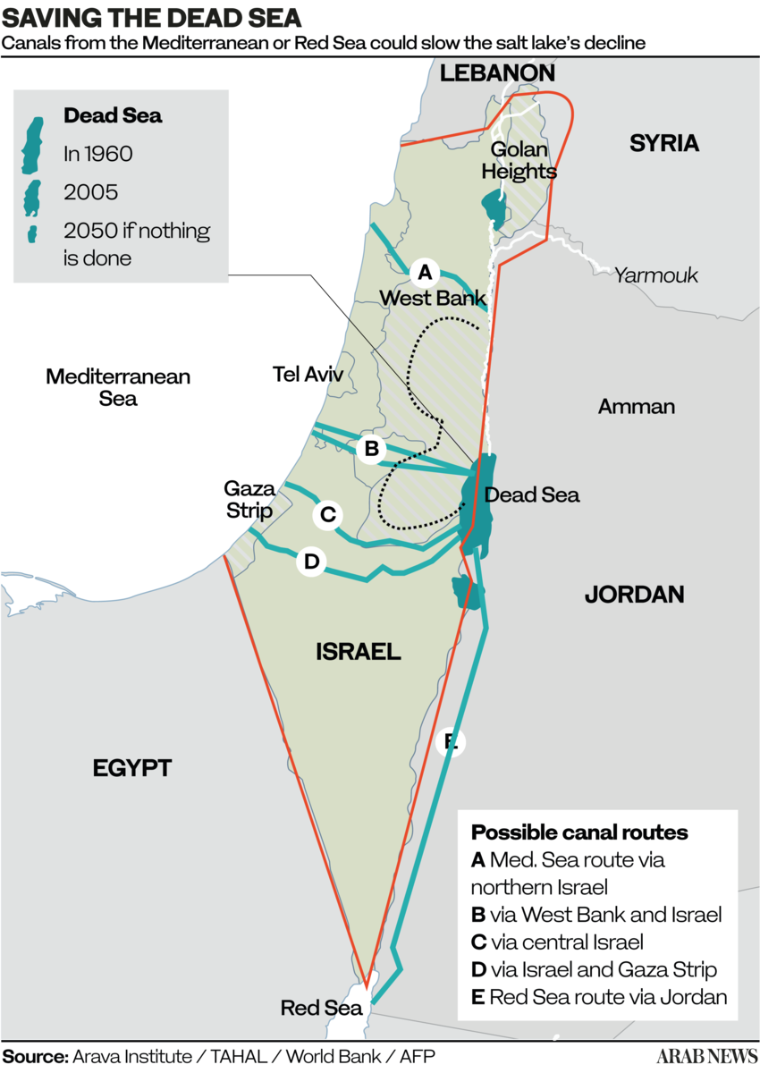
A: Crossing solely Israelian territory;
B and C: Crossing Israel and West Bank (shortest, 70 km);
D. Crossing Gaza and Israel;
E. Crossing only Jordan (longest, 200 km).
The idea of a Dead Sea-Mediterranean Canal was first proposed by William Allen in 1855 in a book entitled The Dead Sea – A new route to India. At the time, it was not known that the level of the Dead Sea was far below that of the Mediterranean, and Allen proposed the canal as an alternative to the Suez navigation Canal.
Later, several engineers and politicians took up the idea, including Theodor Herzl in his 1902 short story Altneuland. Most early projects were based on the left bank of the Jordan, but a modified form, using the right bank (West bank), was proposed after 1967.
After extensive research, German engineers Herbert Wendt and Wieland Kelm proposed not a navigable canal, but an aqueduct consisting essentially of an overhead gallery running West-East, linking the Mediterranean to the Dead Sea.
Their 1975 detailed project study Depressionskraftwerk am Toten Meer – Eine Projektstudie, on how to use the difference of water levels between the Mediterranean sea (level 0) and the Dead Sea (- 400 m) for power generation was the subject of a first publication in the German journal Wasserwirtschaft (1975,3).
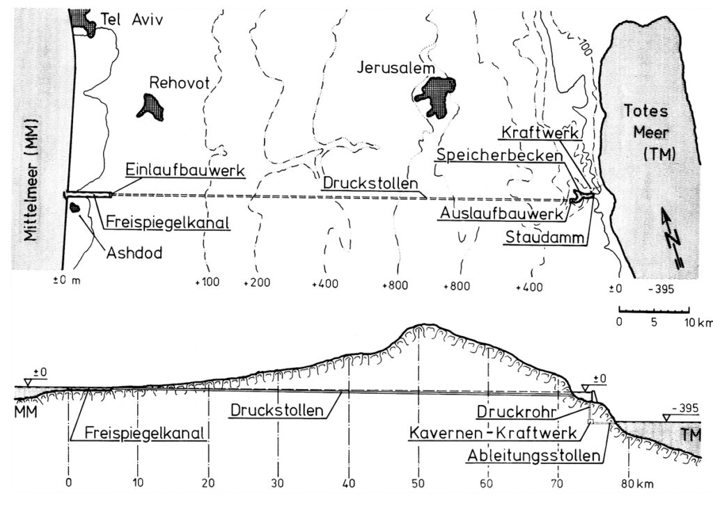
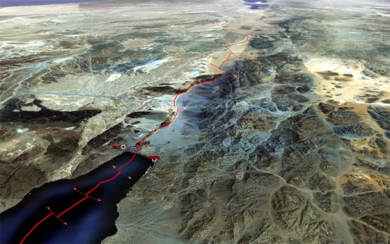
The diagram indicates the system operates as follows:
- The seawater intake is at Ashdod.
- An open channel allows the water to flow by gravity for 7 km.
- From there, the pressurized water travels through a 65 km-long hydraulic gallery;
- The water arrives in a 3km-long reservoir created by a dam on the edge of the steep descent to the Dead Sea. At that point, the water can be used to cool a thermal or nuclear power plant, the heat from which can be used for industrial or agricultural purposes.
- Through a shaft running from the bottom of the reservoir, the water descends a steep 400 metres.
- There, it powers three turbines, each producing 100 MWe.
- Finally, via an evacuation gallery, the seawater reaches the Dead Sea.
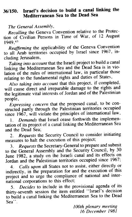
However, since the project was elaborated exclusively by Israel and without any consultation with its Jordanian, Egyptian and Palestinian neighbors, the project ran against a wall of political opposition.
Of course, as with any large scale infrastructure projects, many things needed to be adapted, including tourist equipment, roads, hotels, Jordanian potash exploitation, Palestinian farmland, etc.
Questions were also raised about (very infrequent) potential earthquakes and the difference of salinity of water from the Mediterranean and the Dead Sea.
On Dec. 16, 1981, the UN General Assembly, arguing the canal project « will violate the principle of international law » adopted Resolution 36-150.
That resolution requested the UN Security Council « to consider initiating measures to halt the execution of this project » and calling « upon all States not to assist, either directly or indirectly, in the preparation for and the execution of this project. »
The request, in article 3, to submit a study was fulfilled. The report, not really convincing, details various objections but doesn’t call into question the technical feasability of the project.
E. Red Sea – Dead Sea Water Conveyance
OBJECTIVES: Build a desalination plant close to the Dead Sea to provide fresh water to Jordan, Israel and Palestine by desalinating seawater arriving via a pipeline from the Red Sea. Use the brine to refill the Dead Sea. Use the watersharing as a model for peaceful mutual beneficial cooperation. Make the project the heart of a development corridor.
In the framework of the peace treaty between Israel and the Hashemite Kingdom of Jordan the integrated development Master Plan for the Jordan Rift Valley (JRV) was studied in the mid 1990’s.
The Red Sea – Dead Sea Canal (RSDSC) was considered to be one of the most important potential elements for implementing this Master Plan. The principal development objective of the RSDSC was to provide desalinated drinking water for the people of the area.
On October 17, 1994, then Israeli Prime Minister Yitzhak Rabin and King Hussein of Jordan validated the draft peace treaty between their two countries in Amman, after reaching agreement on the last two points in dispute – the water issue and border demarcation.
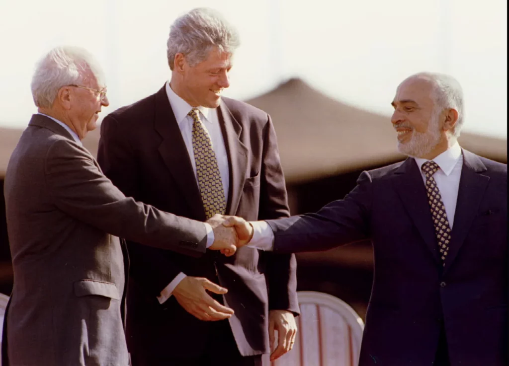
On November 26, the Israeli-Jordanian peace treaty was signed with great fanfare in the Arava Valley, between the Red Sea and the Dead Sea, by the prime ministers of the two countries, in the presence of US President Bill Clinton, whose country had helped bring the negotiations between Jerusalem and Amman to a successful conclusion.
This created the condition where the old idea of linking the Red Sea with the Dead Sea, a project renamed and supported by Shimon Peres as the « Peace Canal », could come back on the table.
Former Israeli water commissioner Professor Dan Zaslavsky, who opposed the project on cost grounds, wrote in the Jerusalem Post in 2006 about Peres’ obstinacy. To listen to the scientists, Peres summoned five of them. Each had to present his objections in a few minutes.
« At one point, Peres got up and said, ‘Excuse me. Don’t you remember that I built the nuclear reactor in Dimona? Do you remember that everyone was against it? Well I was right in the end. And this will prove to be the same thing! » And with that, Zaslavsky said with a flourish, « he left! »
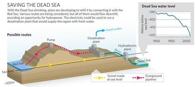
The Dead Sea
For millennia, the Dead Sea was filled with fresh water from the Jordan River, via Lake Tiberias. Over the last fifty years, however, it has lost 28% of its depth and a third of its surface area. Its water level is falling inexorably, at an average rate of 1.45 meters per year. Its high salinity – over 27%, compared with the average for oceans and seas of 2-4% – and a level 430 meters below sea level, has always fascinated visitors and provided therapeutic benefits. Stretching 51 kilometers long and 18 kilometers wide, it is shared by Israel, Jordan and the West Bank.
The over-exploitation of upstream water resources (the National Aqueduct in Israel, the Ghor Canal in Jordan), together with potassium mining, is the cause of the sand desert which, if nothing is done, will continue to replace the Dead Sea.
If the Dead Sea needs the Jordan River, the Jordan River needs Lake Tiberias, from which it takes its source. However, the lake too has been affected by drastic drops in its water level in recent years, triggering a vicious circle between the three systems (Lake Tiberias, Jordan River and Dead Sea).
Aqueduct
In response, at the end of 2006, the World Bank and Agence Française de Développement (AFD) assisted Israel and Jordan in the design of a colossal project to link the Dead Sea to the Red Sea via a 180-kilometer mainly underground pipeline.
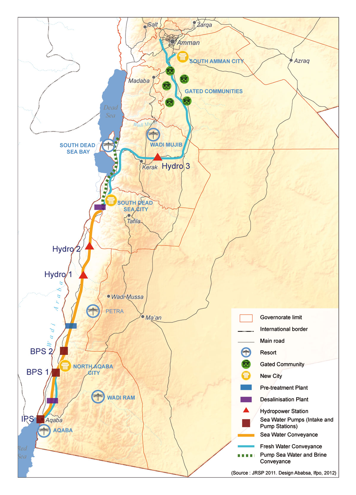
In the end, the project for an aqueduct starting from the Red Sea and built entirely on Jordanian territory was chosen, with the signing of a tripartite agreement between Israelis, Jordanians and Palestinians in December 2013.
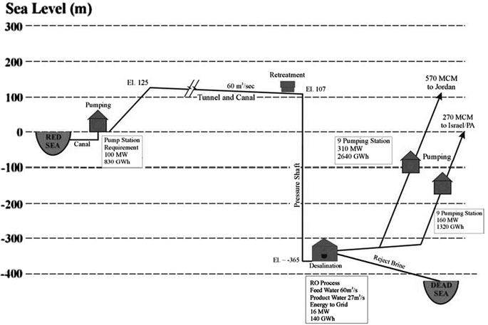
- Sea intake and pumping station
The seawater is pumped to +125 m above sea level at the Red Sea. - Pressure pipeline
The first part of the conveyance system transmits the seawater to the planned elevation. The length is 5 km from Aqaba (3% of the whole alignment). - A tunnel and canal conveyance system
Seawater is transmitted to the regulating and pretreatment reservoirs with a design flow of 60 m3 /s. A 121 km tunnel with 7 m diameter and 39 km canal were designed. - Regulating and pre-treatment reservoirs
Several reservoirs were designed at +107 m at Wadi G’mal at the southeastern margin of the Dead Sea. - Desalination plants
The 2 desalination plants are designed to operate by using the process of hydrostatically supported reverse osmosis to provide desalinated seawater. The main plant will be located at Safi at 365 m below the sea level with a water column of 475 m. - Fresh water
The project will produce around 850 MMC of fresh water per year, to be shared between Jordan, Israel and Palestine, the three countries that manage the Dead Sea. For the transmission of the water to Amman a double pipeline of 200 km with 2.75 m diameter was designed with nine pumping stations for the uplift of 1,500 m. For the transmission to Hebron a double pipeline of 125 km with an elevation difference of 1,415 m was designed. - The brine
The brine reject water will be conveyed from the desalination plant via a 7 km canal to the Dead Sea. 1,100 MMC per year of brine reject water will enter the Dead Sea. - Electricity generation
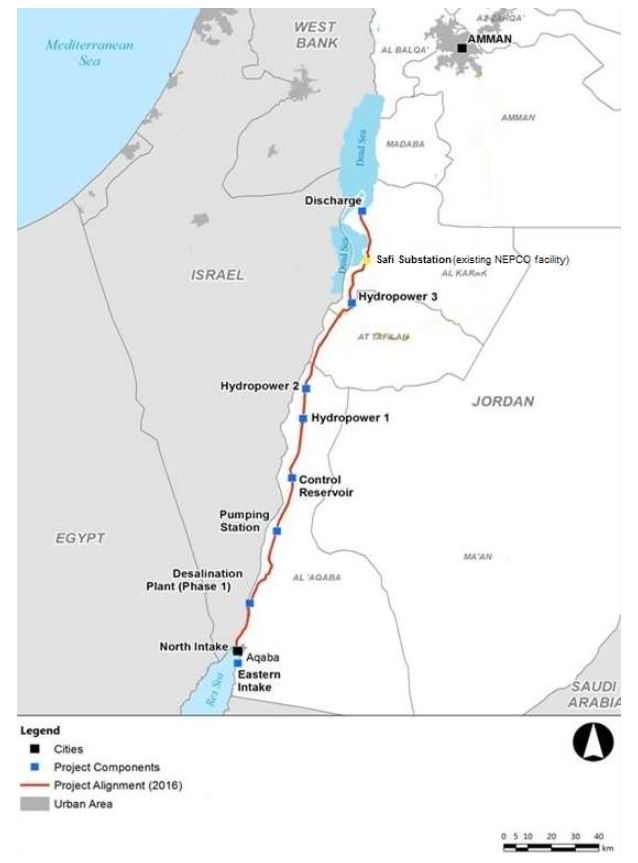
As the brine runs through the tunnel and canal, the turbines of one or more hydroelectric power plants will generate around 800 megawatts of electricity to partially offset the electricity consumed by pumping; - Three new cities will be built: North Aqaba city in northern Aqaba, South Dead Sea City, close to the desalination plant south of the Dead Sea, and South Amman City (see map at the beginning of this section).
In terms of environmental impact, scientists have expressed concern that mixing the brine (rich in sulfate) from the desalination plants with the Dead Sea water (rich in calcium) could cause the latter to turn white. It would therefore be necessary to proceed with a gradual water transfer to observe the effects of water transfer in this particular ecosystem.
Not enough to stabilize the level of the Dead Sea, but a first step to start slowing down its drying up, emphasized Frédéric Maurel, in charge of this project for AFD, in 2018. « We also need to use water more sparingly, both in agriculture and in the potash industry, » he stressed.
Political will?
In 2015, as a supplement to the program, agreements had been reached on reciprocal water sales: Jordan would supply drinking water to Israel in the south, which in return would increase its sales of water from Lake Tiberias to supply northern Jordan. And the Palestinians would also receive additional water supplies from Israel. By the end of 2016, five consortia of companies had been shortlisted.
In 2017, the European Investment Bank produced a 264 page detailed study to support the plan.
On the Israeli side, saving the Dead Sea is a necessity to maintain seaside tourism and thermalism. It is also a lever to guarantee its hydraulic control over the West Bank, as Israel does not trust the Palestinian Authority to manage water. Honest elements of the Hebrew state are aware of the peacemaking potential of this project, and need a stable partner in the region. Jordan, for its part, was by far the most interested in this project, given its critical situation.
In 2021, Jordan decided to put an end to the joint water pipeline project, believing that there was « no real desire on the part of the Israelis » for the plan, which had stagnated for several years, to go ahead.
To face its growing needs, Jordan has decided to build its own desalination plant directly on the Red Sea. The Aqaba-Amman Water Desalination and Conveyance Project will take water from the Red Sea at the Gulf of Aqaba in the south, desalinate it, and channel it 450 kilometres north to the capital Amman and its surrounding area, supplying a desperately needed 300 million cubic metres of water a year. Studies are complete and construction will start on July 2024. The plant will be powered with solar energy.
In 2022, Jordan, the UAE and Israel signed a memorandum of understanding (MoU) to continue feasibility studies for two interconnected projects: establishing the water desalination station at the Red Sea (Prosperity Blue) and establishing a solar power plant in Jordan (Prosperity Green). However, due to the ongoing war against Gaza and the rejection of the Jordanian public regarding the agreement’s signing, the Jordan government announced the suspension of the agreement.
The Dead Sea might slowly reappear
With huge desalinization capacities in hand, Israel adopted in 2023 the National Carrier Flow Reversal Project to return water to its natural resources, in particular to Lake Tiberias, the very source of freshwater for its entire national water system.
Lake Tiberias, as we have seen, is therefore a national treasure, a centerpiece of tourism, agriculture and, as we have seen, geopolitics.
According to Dodi Belser, Director of Innovation at water state giant Mekorot, if Israel wants to increase the water it sends to its Jordanian neighbors and to protect its reservoir, it’s vital to retain the lake’s water level. Currently Israel taps 100 million cubic meters of water from Lake Tiberias to send to Jordan, and did so even during the drought years of 2013 to 2018.
Increase resilience to climate chaos and preparing eventual futur water sharing, gave birth to the idea to pump desalinated water into the Lake Tiberias, up to 120 million cubic meters a year until 2026. That is happening right now.
It can partly increase the level of the Jordan river and therefore the water arriving into the Dead Sea. But the salt in the Dead Sea comes from the waters of the Jordan River. Every year, the famous river brings it some 850,000 tonnes of salt.
F. Turkish water sales
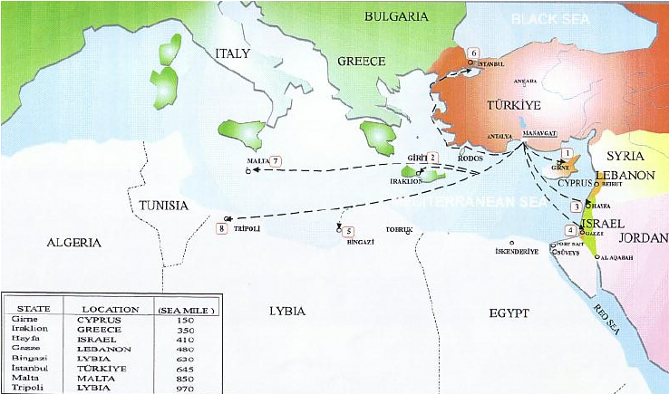
Turkye, a veritable « water tower » in the region, has long dreamed of exporting its water to Israel, Palestine, Cyprus and other Middle Eastern countries at a premium.
The most ambitious of these projects was President Turgut Ozal‘s « Peace Water Pipeline » in 1986, a $21 billion project to pipe water from the Seyhan and Ceyhan rivers to cities in Syria, Jordan and the Arab states of the Gulf.
In 2000, Israel was strongly considering purchasing 50 million m3 per year for 20 years from the Manavgat river near Antalya, but since November 2006, the deal has been put on hold.

The Manavgat project, technically completed in mid-March 2000, was a pilot project.
The complex on the Manavgat river – which rises in the Taurus mountains and flows into the Mediterranean between Antalya and Alanya – includes a pumping station, a refining center and a ten-kilometer-long canal. The aim was then to transport this fresh water by 250,000-ton tankers to the Israeli port of Ashkelon for injection into the Israeli NWC.
Eventually, Jordan was also interested in Turkey’s aquatic manna. A second customer downstream of its network would enable Israel to share costs. Another possibility would be to transport the water via a water pipeline linking Turkey to Syria and Jordan, and ultimately to Israel and Palestine if the latter could reach an agreement with its partners. The Palestinians, for their part, have been looking for a donor country to subsidize freshwater imports by tanker to Gaza.
The Manavgat project is not the only one through which Ankara hopes to sell its water. In 1992, Suleyman Demirel, then Prime Minister, expressed a credo that went viral: « Turkey can use the waters of the Tigris and Euphrates rivers as it sees fit: Turkey’s water resources belong to Turkey, just as oil belongs to Arab countries.”
The countries downstream of the two rivers – Iraq and above all Syria – immediately protested. For them, the multiple dams that Ankara plans to build on the region’s main freshwater sources for irrigation or power generation are simply a way for the heir to the Ottoman Empire to assert its authority over the region.
Whatever Ankara’s real ambitions, the country has a real treasure trove at its disposal, especially given the dwindling resources of neighboring countries.
In the end, since November 2006, Israeli supporters of desalination have objected to the price of Turkish water and questioned the wisdom of relying on Ankara, whose government is critical of Israeli policies. Desalination or importation? The choice is a Cornelian one for Israel. And an eminently political one, since it comes down to knowing whether to stick to positions based on self-sufficiency or whether to play the regional cooperation card, which amounts to betting on trust…
G. Hidden defects and non-implementation of Oslo
The recognition of Israel by Yasser Arafat – leader of the Palestinian Liberation Organisation –, and the election of Yitzhak Rabin as Israel’s Prime minister in 1992 opened new opportunities for peace and cooperation. The Oslo accords they signed established the Palestinian Authority and determined temporary groundwater allocations from the West Bank to Israel and Palestine. In the declaration, both parties agreed on the principle of “equitable utilisation” between Palestinians and Israelis.
The collapse of mutual trust following the assassination of Rabin in November 1995 and the subsequent election of Benjamin Netanyahu, who had been highly critical of Oslo, negatively affected cooperation on water.
In 2000, during the first six months of the second Intifada, there was hardly any contact between both sides regarding water issues. But with reason coming back, despite the conflict, Israeli and Palestinian leaders committed themselves to separating the water issue from violence and reactivated cooperation over water.
In 2004, Israel reportedly proposed a plan to build a desalination plant in order to increase the quantity of freshwater available and to channel desalinated water to the West Bank. Fearing that this might in effect imply a renunciation to Palestinian water claims on the Mountain aquifer (75% of which is allocated to Israel even though the Aquifer is on Palestinian land), the Palestinians rejected this solution.
The Oslo Accords, signed by Israel and the Palestine Liberation Organization (PLO) in 1993, although stipulating that « Israel recognizes the water rights of Palestine », in reality allowed Israel to continue controlling the region’s water sources… while awaiting a resolution to the conflict. Oslo II provided for the postponement of negotiations on water rights until those on permanent status, as well as on the status of Jerusalem, refugees’ right of return, illegal settlements, security arrangements and other issues.
But final status talks, scheduled to take place five years after the implementation of the Oslo Accords (in 1999, as planned), have not yet taken place.
The Oslo Accords also provided for the creation of a water management authority, and their « Declaration of Principles » stressed the need to ensure « the equitable use of common water resources, for application during the interim period [of the Oslo Accords] and thereafter ».
Hence, for decades, Israel has perpetuated a principle of water distribution that existed before the Oslo Accords were signed, allowing Israelis to consume water at will while limiting Palestinians to a predetermined 15% share.
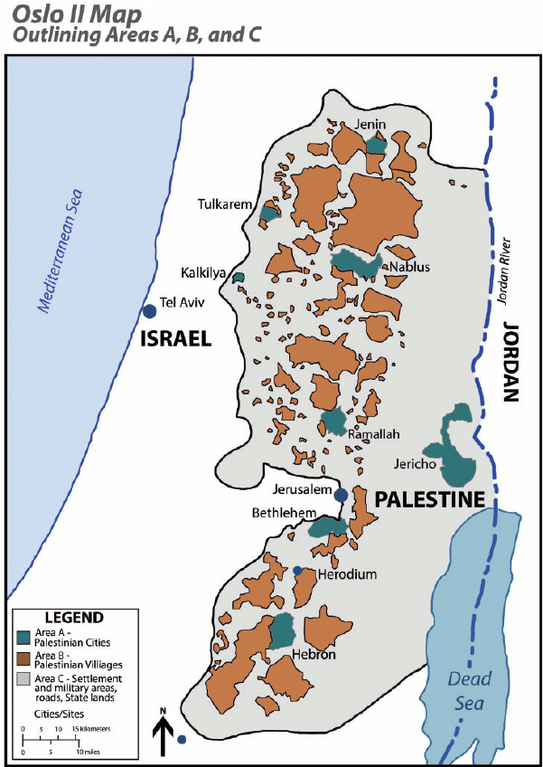
The Oslo agreements did not take into account the division of the West Bank into zones A, B and C when it came to organizing water distribution between Israel and the Palestinians.
Israel was finally granted the right to control water sources, even in PA-controlled areas A and B.
Most water sources were already located in Area C, which is entirely controlled by Israel and comprises almost 61% of the West Bank.
On the ground, Israel has connected all the settlements built in the West Bank, with the exception of the Jordan Valley, to the Israeli water network. The water supply to Israeli communities on both sides of the Green Line is managed as a single system, under the responsibility of Israel’s national water company, Mekorot.
While the Oslo Accords allowed Israel to pump water from areas under its control to supply settlements in the occupied West Bank, they also prevent the PA from transferring water from one area to another in those it administers in the West Bank. Israel has disavowed most of the provisions of the Oslo Accords, but remains committed to those relating to water.
A member of the Palestinian delegation that signed the Oslo Accords, wishing to remain anonymous, tells Middle East Eye magazine that the delegation’s lack of expertise at the time resulted in the signing of an agreement that
« placed the fate of Palestinian access to water in Israel’s hands (…) Most Palestinian water experts withdrew from the negotiations at the outset of the Oslo process, as they were not satisfied with the way the negotiations were being conducted », he stressed. « As for the political leaders, their main objective was to reach an agreement. »

In practice, this means that Palestinians in the occupied West Bank are at the mercy of the Israeli occupation when it comes to their water supply.
Inequalities in terms of access to water in the West Bank are glaring, as shown by the Israeli NGO B’Tselem in a report entitled Parched, published in May 2023.
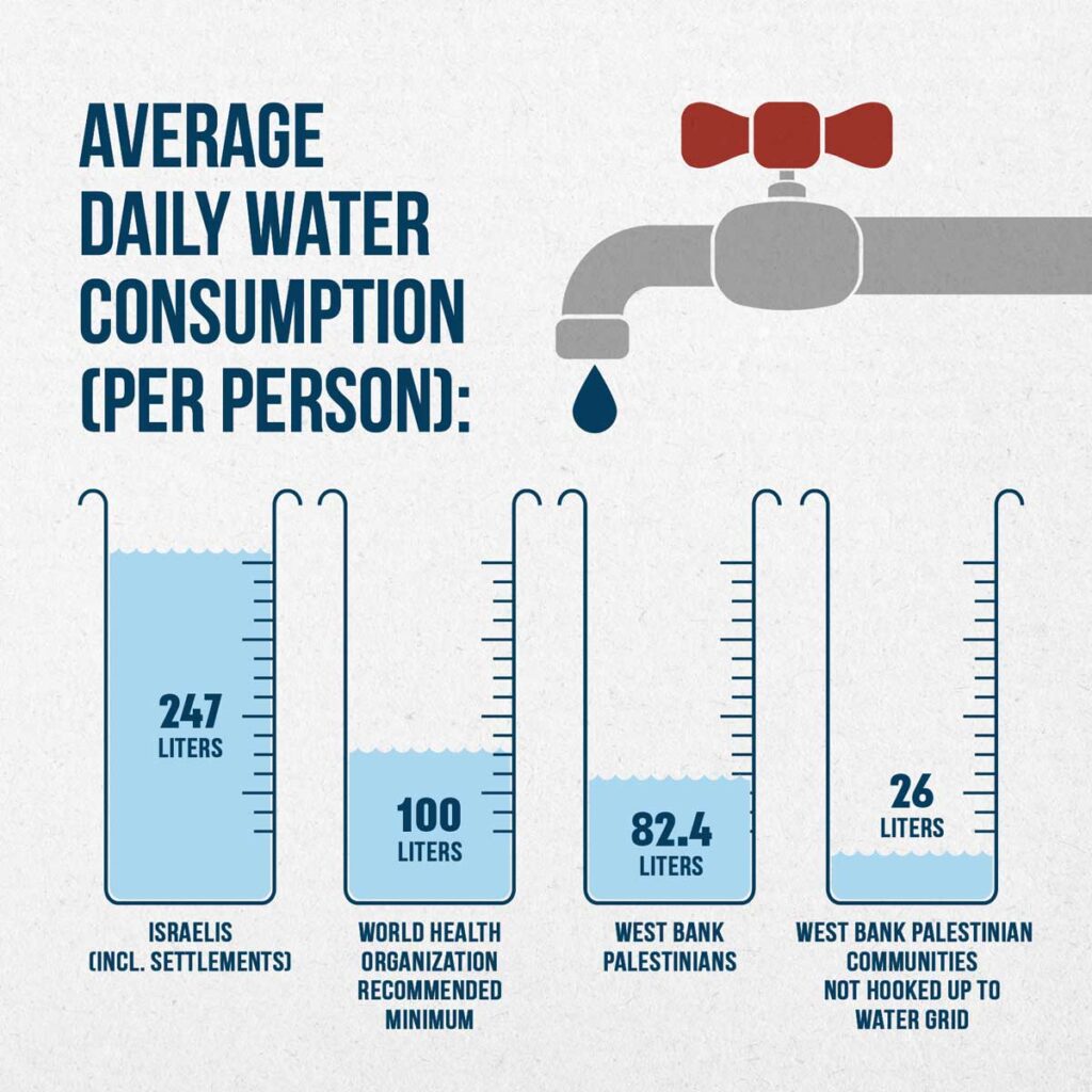
In 2020, each Palestinian in the West Bank consumed an average of 82.4 liters of water per day, compared with 247 liters per person in Israel and the settlements.
This figure drops to 26 liters per day for Palestinian communities in the West Bank that are not connected to the water distribution network. 36% of West Bank Palestinians have year-round access to running water, compared with 100% of Israelis, including settlers.
The Palestinian Authority, which claims more water, points out that Palestinian agriculture plays a major role in the economy of the Occupied Territories (15% of GDP, 14% of the working population in 2000). In comparison, Israeli agriculture, while far more productive, employs 2.5% of the working population and produces 3% of GDP.
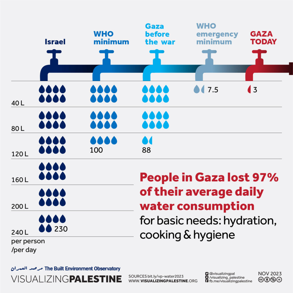
Added to this the fact that the arable land recognized by Israel under the Oslo Accords as totally or partially autonomous to the Palestinians is located in the limestone uplands, where access to water is difficult, since it is necessary to dig deep to reach the water table.
What’s more, in Israel and the settlements, 47% of land is irrigated, compared with only 6% of Palestinian land. The Palestinian Authority is currently demanding rights to 80% of the mountain aquifer, which Israel cannot conceive of.
Myth of Thirsty Palestinian
Israeli spokespeople, such as Akiva Bigman in his article titled « The Myth of the Thirsty Palestinian » have three answers ready to pull out when they are confronted with the water shortages in West Bank Palestinian towns:
1) “Because the PA does not properly maintain its water system, it suffers from a 33 percent rate of water loss, mostly due to leakage; in contrast to an 11 percent loss from the Israeli system.”
Answer: leakage varies from 20 to 50% in the USA, far above the rate of poor Palestine.
2) “40 potential drilling sites in the Hebron area were identified and approved by the Israeli-Palestinian Joint Water Committee; but in the two decades since then, drilling has taken place in only three places, and this is in spite of substantial funding provided to the PA by donor nations.”
One can ask where the money went. And yes, in reality, at the end of the day, for various technical reasons and unexpected drilling failures in the eastern basin of the aquifer (the only place the agreement allows the Palestinians to drill), the Palestinians ended up producing less water than the agreements set.
3) Israel has in its great generosity “doubled the amount of water it supplies to the Palestinians, compared to what was called for in the Oslo Accords.”

True. However, Oslo didn’t set a limit to the amount of water Israel can take, but limited the Palestinians to 118 MCM from the wells that existed prior to the accords, and another 70-80 MCM from new drilling. According to the Israeli NGO B’Tselem, as of 2014 the Palestinians are only getting 14 percent of the aquifer’s water. That is why the Israeli state company Mekorot (obeying to government directives) is selling the Palestinians the double of water stipulated in the Oslo Agreement – 64 MCM, as opposed to 31 MCM. 64 + 31 = 95 MCM in total, to be compated with current consumption by Palestinians in the West Bank: 239 MCM of water in 2020 of which 77.1 of them purchased from Israel.
A final detail that speaks volumes: Palestinians are charged the price of drinking water for their agricultural water while Jewish settlers benefit from agricultural tariffs and subsidies. The justification being that the Jewish settlers have invested in expensive irrigation techniques such as desalination
H. Ben Gurion Navigation Canal
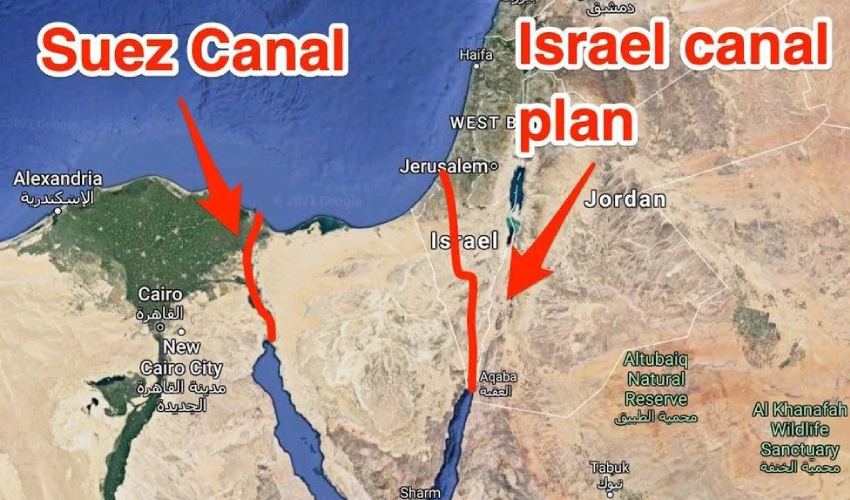
At the end of 2023, the idea of the Ben-Gurion navigation Canal project was revived in the media. The canal would link the Gulf of Aqaba (Eilat) in the Red Sea to the Mediterranean Sea, passing through Israel to terminate in or near the Gaza Strip (Ashkelon). This is an Israeli alternative to the Suez Canal, which became topical in the 1960s following Nasser’s nationalization of Suez.
The first ideas for a connection between the Red Sea and the Mediterranean appeared in the mid-19th century, on the initiative of the British, who wanted to link the three seas: the Red, the Dead and the Mediterranean. As the Dead Sea lies 430.5 meters below sea level, such an idea was not feasible, but it could be realized in another direction. Frightened by Nasser’s nationalization of Suez, the Americans considered the option of the Israeli canal, their loyal ally in the Middle East.
In July 1963, H. D. Maccabee of Lawrence Livermore National Laboratory, under contract to the U.S. Department of Energy, wrote a memorandum exploring the possibility of using 520 underground nuclear explosions to help dig some 250 kilometers of canals across the Negev desert. The document was classified until 1993. « Such a canal would constitute a strategically valuable alternative to the present Suez Canal and would probably contribute greatly to the economic development of the surrounding region, » says the declassified document.
The idea of the Ben Gurion Canal resurfaced at the same time as the signing of the so-called « Abraham Agreements » between Israel and the United Arab Emirates, Bahrain, Morocco and Sudan.
On October 20, 2020, the unthinkable happened: Israel’s state-owned Europe Asia Pipeline Company (EAPC) and the UAE’s MED-RED Land Bridge signed an agreement to use the Eilat-Ashkelon pipeline to transport oil from the Red Sea to the Mediterranean, avoiding de facto the Suez Canal.
On April 2, 2021, Israel announced that work on the Ben Gurion Canal was due to start in June of the same year. But this has not been the case. Some analysts interpret the current Israeli reoccupation of the Gaza Strip as an event that many Israeli politicians were waiting for to revive an old project.
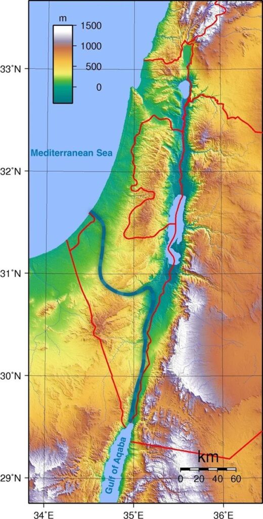
A closer look at the planned route shows that the canal starts at the southern edge of the Gulf of Aqaba, from the port city of Eilat, close to the Israeli-Palestinian border, and continues through the Arabah valley for around 100 km, between the Negev mountains and the Jordanian highlands. It then turns west before the Dead Sea, continues through a valley in the Negev mountain range, then turns north again to bypass the Gaza Strip and reach the Mediterranean Sea in the Ashkelon region.
The project’s promoters argue that their canal would be more efficient than the Suez Canal because, in addition to being able to accommodate a greater number of ships, it would allow the simultaneous two-way navigation of large vessels thanks to the design of two canal arms.
Unlike the Suez Canal, which runs along sandy banks, the Israeli canal would have hard walls that require almost no maintenance. Israel plans to build small towns, hotels, restaurants and cafés along the canal.
Each proposed branch of the canal would be 50 meters deep and around 200 meters wide. It would be 10 meters deeper than the Suez Canal. Ships 300 meters long and 110 meters wide could pass through the canal, corresponding to the size of the world’s largest ships.
If completed, the Ben-Gurion Canal would be almost a third longer than the Suez Canal, which measures 193.3 km, or 292.9 km. Construction of the canal would take 5 years and involve 300,000 engineers and technicians from all over the world. Construction costs are estimated at between $16 and $55 billion. Israel stands to gain $6 billion a year.
Whoever controls the canal, and apparently it can only be Israel and its allies (mainly the USA and Great Britain), will have enormous influence over international supply chains for oil, gas and grain, as well as world trade in general.
Israel argues that such a project would undermine the power of Egypt, a country strongly allied with Russia, China and the BRICS and therefore « a threat » to the West! With the depopulation of Gaza and the prospect of total Israeli control over this tiny territory, some Israeli politicians, including Netanyahu, are once again salivating over the prospect of such a project.
As Croatian analyst Matia Seric pointed out in Asia Review in November 2023:
« If realized, the Ben Gurion Canal would bring about a tectonic change as it would overshadow the Suez Canal. The project would launch Israel into the center of world shipping and world trade. Egypt would lose its monopoly on the shortest route between Africa, Asia and Europe. The emergence of an alternative Israeli channel would have a devastating impact on the Egyptian economy. President el-Sisi may regret putting his trust in Israel and Western governments above the well-being of the two million Palestinians in Gaza. Egypt, apart from formally condemning the mass crimes committed by Israeli forces against the civilian Palestinian population, has done little to prevent Israeli wrongdoing, which some call genocide. Israeli Prime Minister Benjamin Netanyahu has repeatedly expressed support for the idea of the canal along with the idea of building a high-speed railway from Eilat to Beersheba. Realizing, or at least starting, this project could redeem Netanyahu from his many mistakes during his long reign, including the intelligence and military failures that facilitated the October 7 attack by Hamas. »
I. Oasis Plan
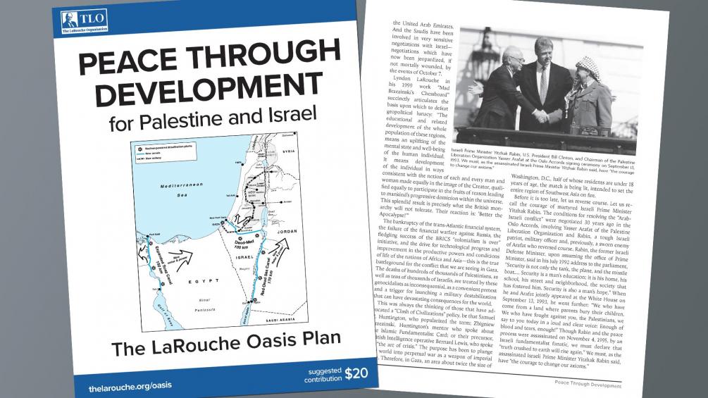
It is in the light of all these failures that the fundamental contribution of the « Oasis Plan » proposed by the American economist Lyndon LaRouche (1922-2019) becomes apparent.
In 1975, following talks with the leaders of the Iraqi Baath Party and sane elements of the Israeli Labor Party, the American economist LaRouche saw his Oasis Plan as the basis for mutual development to the benefit of the entire region.
Instead of waiting for « stability » and « lasting peace » to arrive magically, LaRouche proposed and even launched projects in the interests of all, and « recruited » all partners to participate fully, first and foremost in their own interests, but in reality in the interests of all.

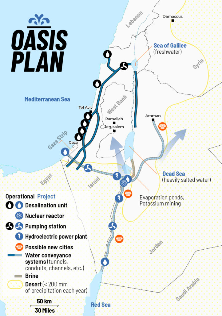
LaRouche’s « Blue Peace » Oasis plan, to be put on the table of diplomatic negotiations as the « spine » of a durable peace agreement », includes:
- Israel’s relinquishment of exclusive control over water resources in favor of a fair resource-sharing agreement between all the countries in the region;
- The reconstruction and economic development of the Gaza Strip, including the Yasser Arafat International Airport (inaugurated in 1998 and bulldozered by Israeli in 2002), a major seaport backed up by a hinterland equipped with industrial and agricultural infrastructure.
- A floating, underwater or off-shore desalination plant will be stationed in front of Gaza.
- The construction of a fast rail network reconnecting Palestine (including Gaza) and Israel to its neighbors;
- The construction, for less than 20 billion US dollars of both the Red-Dead and the Med-Dead water conveyance system composed of tunnels, pipelines, water galeries, pumping stations, hydro-power units and nuclear powered desalination plants.
- Salted sea water, arriving at the Dead Sea, before desalination, will « fall » through a 400 meter deep shaft and generate hydro-electricity.
- Following desalination, the fresh water will go to Jordan, Palestine and Israel; the brine will refill and save the Dead Sea.
- The nuclear powered desalination plant will produce heat and electricity with « hybrid desalination » combining evaporation and Reverse Osmosis (RO) ;
- The industrial heat of the Molten Salt (MSR) high temperature reactors (HTR), will also be tapped for industrial and agricultural purposes;
- The reservoirs of the water conveyance systems will also function as a Pumped Storage Power Plant (PSPP), essential for regulating the region’s power grids;
- Part of the seawater going through the Med-Dead Water conveyance system will be desalinated in Beersheba, the « capital of the Negev » whose population, with new fresh water supplies, can be doubled.
- New cities and « development corridors » will grow around the new water conveyance systems.
- Israel’s Dimona nuclear center and power plant (currently a military reactor and medical nuclear waste treatment center) can form the basis to create a civilian nuclear program and contribute to the construction of nuclear desalination plants. Jordan can supply the uranium.
- US and Israeli plans to prepare the housing of 500,000/1 million people in the Negev exist but should be entirely reconfigured in terms of both scope and intent. They cannot be a mere extension of exclusively Jewish settlements, but should offer the opportunity to all Israeli citizens, in peaceful cooperation with the Bedouins who live there, the Palestinians and others, to roll back a common enemy: the desert.
- The policy of illegal settlements in the West Bank shall be halted. Settlers will be encouraged (through taxation, etc.) to relocate to the Negev, where they, in a shared effort with the Bedouins, Palestinians and others, can take up productive jobs and make the desert bloom (62% of Israeli territory).
PS: The Oasis Plan plan aims to bring peace to all through mutual development. It has nothing to do with Netanyahu’s Ben-Gurion canal project, a megalomaniac plan for a navigation canal connecting the Red Sea with the Mediterranean aimed to compete with the Suez Canal.
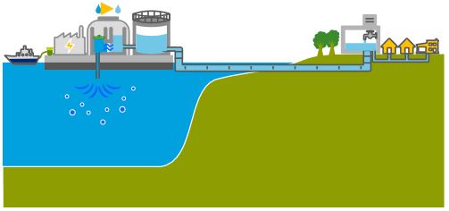
Alvin Weinberg, Yitzhak Rabin and Lyndon LaRouche
LaRouche proposed coupling hydrological, energy, agricultural and industrial infrastructures. These agro-industrial complexes, built around small high-temperature nuclear reactors, were called « nuplexes », a concept put forward in the post-war period by the American scientist Alvin Weinberg, head of the Oak Ridge Laboratories in Tennessee (ORNL) and co-inventor of several types of nuclear reactor, notably the molten-salt line using thorium as fuel (and therefore without the production of weapons-grade plutonium).
In chapter 8 of his autobiography, Weinberg recounts how ORNL, « embarked on a great enterprise: desalinating the sea with cheap nuclear power », with « multi-purpose » plants, « producing water, electricity and process heat at the same time ». The assertion that this was possible, Weinberg reports, « caused a stir within the Atomic Energy Commission ».
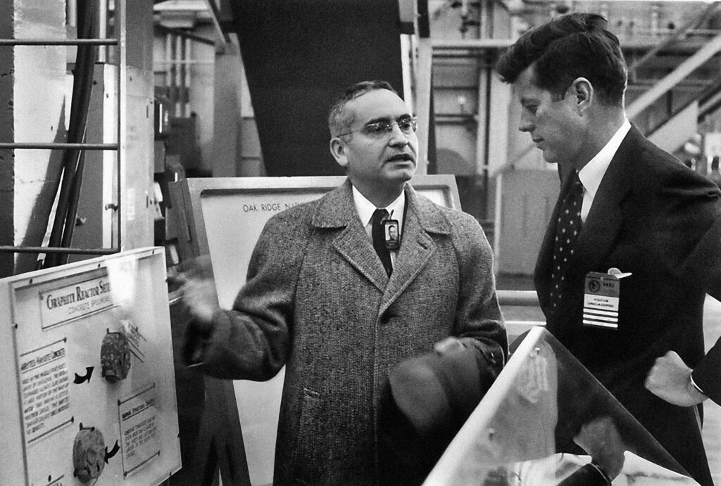
In the end, it was President John F. Kennedy who reacted most enthusiastically, speaking on September 25, 1963:
“We are now examining in the United States today the mixed economic-technical question of whether the very large scale nuclear reactors can produce unexpected savings in the simultaneous desalination of water and the generation of electricity? We will have before this decade is out or sooner a tremendous nuclear reactor which makes electricity and at the same time gets fresh water from salt water at a competitive price. What a difference this can make to the United States. And indeed, not only the US but all around the globe where there are so many deserts on the ocean’s edge.”
The idea reached later the ear of AEC’s patron Lewis Strauss.
“The time was 1967, just after the Six-Day War, and the Middle East was much on our minds. The ultimate problem of the Middle East is water – a point that is now perhaps more fully recognized than it was in 1967. Why not build dual-purpose nuclear and electric desalting plants in Egypt, Israel and Jordan – literally make the deserts bloom– and thereby create a major new possibility for a settlement in the Israeli-Arab conflict?”
Lewis conveyed this idea to Eisenhower and Ike published in Life magazine an outline of what became known as the Eisenhower plan, based “on what Lewis and I had discussed”, writes Weinberg.
ORNL then sent a team to visit Egypt, Israel and Lebanon where they were warmly received. The visit brought to Tennessee Israeli and Egyptian engineers who were integrated in the Middle East Study Project,
“which studied what we called ‘nuclear-powered agro-industrial complexes,’ something already studied in 1966. Such complexes would use nuclear reactors to produce electricity and water; the electricity would be used for both domestic and industrial purposes; the water would be used to grow high-value crops.”
“The Middle East project adapted these earlier results to the Israeli-Egyptian situation. A multi-volume report of the Middle East project was issued in which we examined the feasibility of nuclear agro-industrial complexes to be built as national projects in the El-Hamman area near Alexandria in Egypt, and the western Negev area of Israel, and as an international project near the Gaza strip. The implication was that the complexes would be subsidized by the United States.”
“I met with then-ambassador Yitzhak Rabin of Israel for about an hour at the Knoxville airport to tell him about our results. Rabin, who became prime minister of Israel, was skeptical – both as to the political feasibility of a project conducted jointly by Israelis and Arabs, and the economic feasibility of such a huge undertaking. But most of all he suggested that we had extraordinary chutzpah, sitting in Tennessee and figuring out a scheme to resolve a bitter ethnic dispute some six thousand miles away! Of course Rabin had a point on both scores; but I couldn’t refrain from saying, ‘But Mr. Ambassador, is our drawing up plans in Tennessee for agro-industrial complexes for the Middle East is any sillier than Theodore Herzl’s drawing up plans for Israel, in a Vienna café in 1896?’”
Weinberg, clearly unaware of the Dulles brothers‘ operations sabotaging anything good Ike wanted to accomplish regretted: “The Eisenhower-Baker plan was never implemented: the political will needed to support building large reactors in the strife-riven Middle East was lacking…”
The LaRouche Oasis plan, like any other proposal along the same lines, has so far been blocked by the Israeli, American and British sides, and we know only too well what happened to Yitzhak Rabin, assassinated after signing the Oslo Accords, to Shimon Peres, ousted, and to a demonized Yasser Arafat. In addition, LaRouche has been slandered and called an anti-Semite.
On April 13, 2034, LaRouche’s Oasis Plan and its relevance for today was discussed and debated during an international zoom conference and endorsed by several high level ambassadors and diplomats from Palestine, South Africa, Russia and Guyana.
Similar events are being prepared to continue the discussion and turn this dream into reality.
The science of Oases, from the Indus Valley to Persian qanats

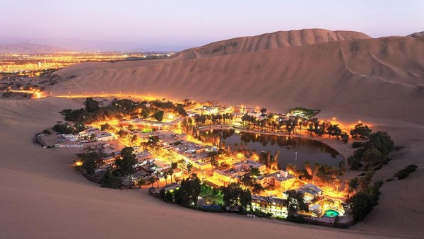
Presentation of Karel Vereycken at the first panel discussion of the « Water for Peace » seminar organized by the Schiller Institute on January 9, 2024 in Paris.

While the dog was domesticated as early as 15,000 years BC, we associate the first human activities aimed at managing water with the Neolithic period, which began around 10,000 BC.
It is thought to be the moment at which mankind moved from a « tribal subsistence economy of hunter-gatherers » to agriculture and animal husbandry, giving rise to villages and cities, where pottery, weaving, metallurgy and the arts would start blooming.
Key to this, the domestication of animals. The goat was domesticated around 11,000 BC, the cow around 9,000 BC, the sheep around -8,000 BC, and finally the horse around 2,200 BC in the steppes of Ukraine.
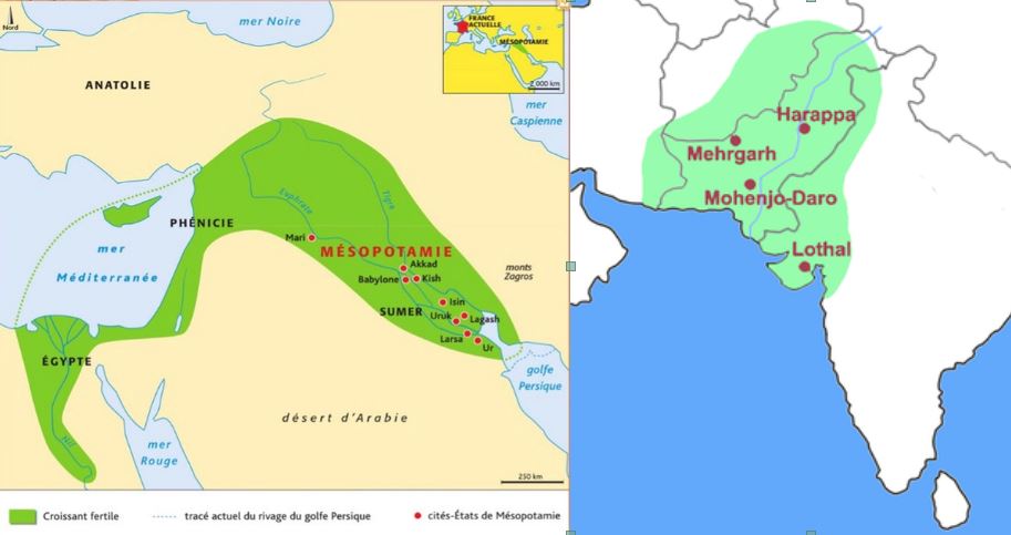
The oldest archaeological sites showing agricultural activities and irrigation techniques were discovered in the Indus Valley and the « Fertile Crescent ».
The site of Mehrgarh, in the Indus Valley, now Pakistan Balochistan, discovered in 1974 by François and Cathérine Jarrige, two French archaeologists, demonstrates important agricultural practices from 7000 BC onward.
Cotton, wheat and barley were grown, and beer was brewed. Cattle, sheep and goats were raised. But Mehrgarh was much more than that.
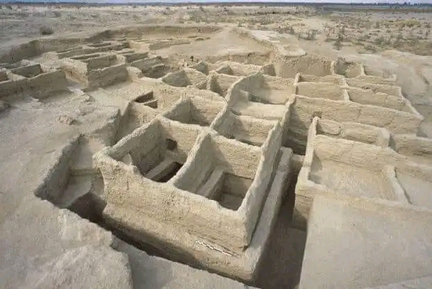
Contradicting the linear « developmental » schema, since we’re in the middle of the Neolithic, Mehrgarh is also home to the oldest pottery in South Asia and, above all, to the “Mehrgahr amulet”, the oldest bronze object casted with the « lost-wax » method.
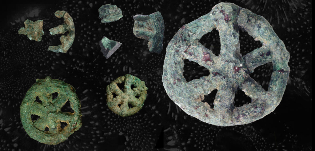
The first seals made of terracotta or bone and decorated with geometric motifs were found here.
On the technological side, tiny bow drills were used, possibly for dental treatment, as evidenced by the pierced teeth of some skeletons found on site.
At the same time, or shortly afterwards, around 6000 B.C., Mesopotamia, between the Tigris and Euphrates rivers, witnessed rapid urban development in terms of demographics, institutions, agriculture, techniques and trade.
A veritable « fertile crescent » emerged in the region stretching from Sumer to Egypt, passing through the whole of Mesopotamia and the Levant, i.e. Syria and the Jordan Valley.
Irrigation
Whether in the Indus Valley, Mesopotamia or Egypt, the earliest irrigation techniques are nothing but retaining as much water as possible when Mother Nature has the sweet kindness to offer it to mankind.
Rainwater was collected in cisterns and, as much as possible, when snowmelt or monsoon rains swell the rivers, the objective was to amplify and steer seasonal « flooding » by canals and trenches carrying the water as far away as possible to areas to be cultivated, while at the same time protecting crops.
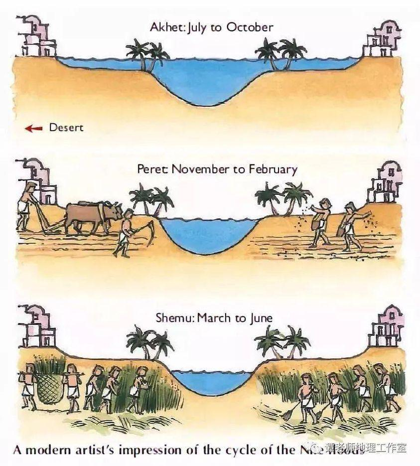
In Egypt, for example, where the Nile rises by around 8 meters, the water brings not only moisture but also silt to the soil near the river, providing crops with the nutrients they need to grow and thus maintain the soil’s fertility.
While the Egyptians complained about the harsh labor condition of their farmers, for the Greek historian Herodotus, this was the place in the world where work was least arduous. Of Egypt he says:
“Its soil is black and crumbly, made of silt and alluvium brought from Ethiopia by the river. Certainly, these people are today, of all the human race in Egypt as elsewhere, those who go to the least trouble to obtain their crops.
« They don’t bother to plough and weed. When the river has come of its own accord to water their fields and, its task done, has withdrawn, each man sows his land and lets the pigs loose: by trampling, the beasts sink the seeds into the earth, and the man has only to wait for the harvest.”
In Mehrgarh, where agriculture was born from 7000 BC, the work was indeed far more demanding.
However, the drainage system around the village and the rudimentary dams to control water-logging indicate that the inhabitants understood most of the basic principles involved. The cultivation of cotton, wheat and barley, as well as the domestication of animals, show that they were also familiar with canals and irrigation systems.
Constantly refined, this know-how enabled the civilization of the Indus Valley to create great cities that impress us by their modernity, notably Harappa and Mohenjo Daro, a city of 40,000 inhabitants with a public bath in its center, not a palace.
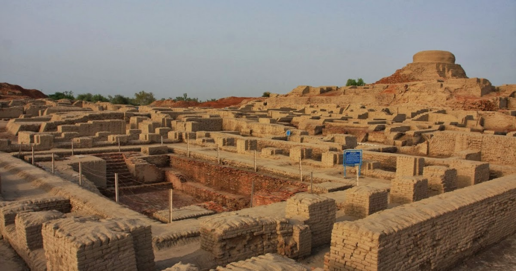
Pioneers of modern hygiene, these towns were equipped with small containers where residents could deposit their household waste.
Anticipating our « all-to-the-sewer » systems imagined in the early XVIth century by Leonardo da Vinci, for example in his plans for the new french capital of Romorantin, many towns had public water supplies as well as an ingenious sewage system.
In the port city of Lothal (now India), for example, many homes had private brick bathrooms and latrines. Wastewater was evacuated via a communal sewage system leading either to a canal in the port, or to a soaking pit outside the city walls, or to buried urns equipped with a hole for the evacuation of liquids, which were regularly emptied and cleaned.
Excavations at the Mohenjo Daro site reveal the existence of no fewer than 700 brick wells, houses equipped with bathrooms and individual and collective latrines.

Many of the city’s buildings had two floors or more. Water trickled down from cisterns installed on the roofs was channeled through closed clay pipes or open gutters that emptied into the covered sewers beneath the street.
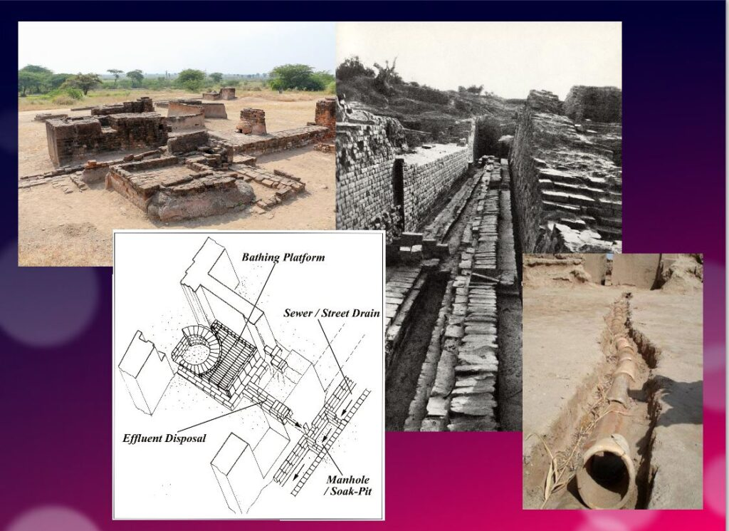
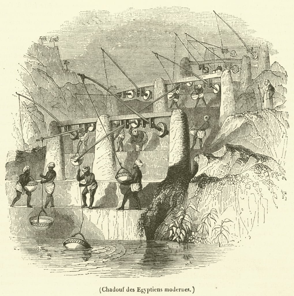
This hydraulic and sanitary know-how was passed on to the civilization of Crete, the mother of Greece, before being implemented on a large scale by the Romans.
It was forgotten with the collapse of the Roman Empire, only to return during the Renaissance.
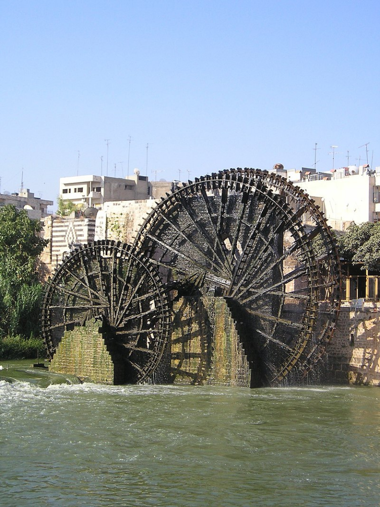
The first human contributions were aimed at maximizing water reservoirs and their gravity-flow capacity. To achieve this, it was necessary to transfer water from a lower level to higher ground and build « water towers ».
To this end, the Mesopotamian « chadouf » was widely used in Egypt, followed by the « Archimedean screw ».
Next came the « saquia » or « Persian wheel », a geared wheel driven by animal power, and finally the « noria », the best-known water-drawing machine, powered by the river itself.
Persian qanats
Before Alexander the Great, Persia’s Achaemenid Empire (6th century BC) developed the technique of underground qanats or underground aqueducts. This « draining gallery” cut into the rock or built by man, is one of the most ingenious inventions for irrigation in arid and semi-arid regions.
Whatever displeases our environmentalist friends, it’s not nature that magically produces « oases » in the desert.
It’s a scientific man who digs a drainage gallery from a water table close enough to the ground surface, or sometimes from an aquifer that flows into the desert.
On the website of ArchéOrient, archaeologist Rémy Boucharlat, Director of Emeritus Research at the French CNRS, an expert on Iran, explains:
« Whatever the origin of the water, deep or shallow, the gallery construction technique is the same. The first step is to identify the presence of the water, either its underflow near a river, or the presence of a deeper water table on a foothill, which requires the science and experience of specialists.
A motherwell reaches the upper part of this layer or water table, which indicates the depth at which the gallery should be dug. The slope of the gallery must be very shallow, less than 2‰, to ensure a calm and regular flow of water, and to gradually lead the water to the surface, at a gradient much lower than the slope of the piedmont.
The gallery is then excavated, not from the mother well, as it would be flooded immediately, but from downstream, from the arrival point. The pipe is first dug as an open trench, then covered, and finally gradually tunnelled into the ground.
Shafts are dug from the surface at regular intervals, between 5 and 30 m depending on the nature of the terrain, to evacuate soil and provide ventilation during excavation, and to mark the direction of the tunnel.”
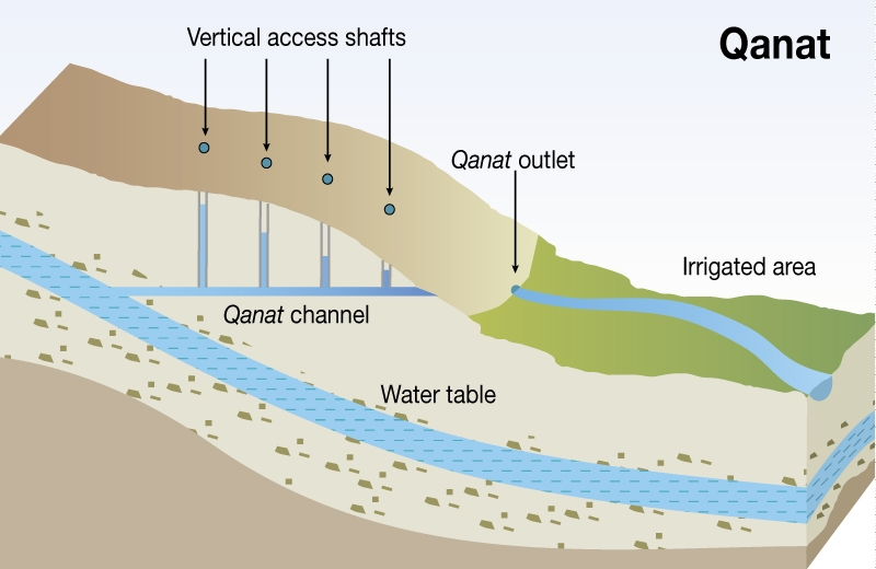
Historically, the majority of the populations of Iran and other arid regions of Asia and North Africa depended on the water supplied by qanats; settlement areas thus corresponded to the places where their construction was possible.
The technique offers a significant advantage: as the water moves through an underground conduit, not a drop of water is lost through evaporation.
This technique spread throughout the world under various names: qanat and kareez in Iran, Syria and Egypt, kariz, kehriz in Pakistan and Afghanistan, aflaj in Oman, galeria in Spain, kahn in Balochistan, kanerjing in China, foggara in North Africa, khettara in Morocco, ngruttati in Sicily, bottini in Siena, etc.).
Improved by the Greeks and amplified by the Etruscans and the Romans, the qanats technique was carried by the Spaniards across the Atlantic to the New World, where numerous underground canals of this type still operate in Peru, Chile and western Mexico.
After Alexander the Great, Bactria, covering parts of today’s Uzbekistan, Turkmenistan and the northern part of Afghanistan, was even known as the « Oasis civilization » or the “Land of a 1000 Golden Cities”.
Iran boasts it had the highest number of qanats in the world, with approximately 50,000 qanats covering a total length of 360,000 km, about 9 times the circumference of the Earth !
Thousands of them are still operational but increasingly destabilized by erratic well digging and demographic overconcentration.
Shared responsability
In 1017, the Baghdad-based hydrologist Mohammed Al-Karaji provided a detailed description of qanat construction and maintenance techniques, as well as legal considerations about the collective management of wells and pipes.
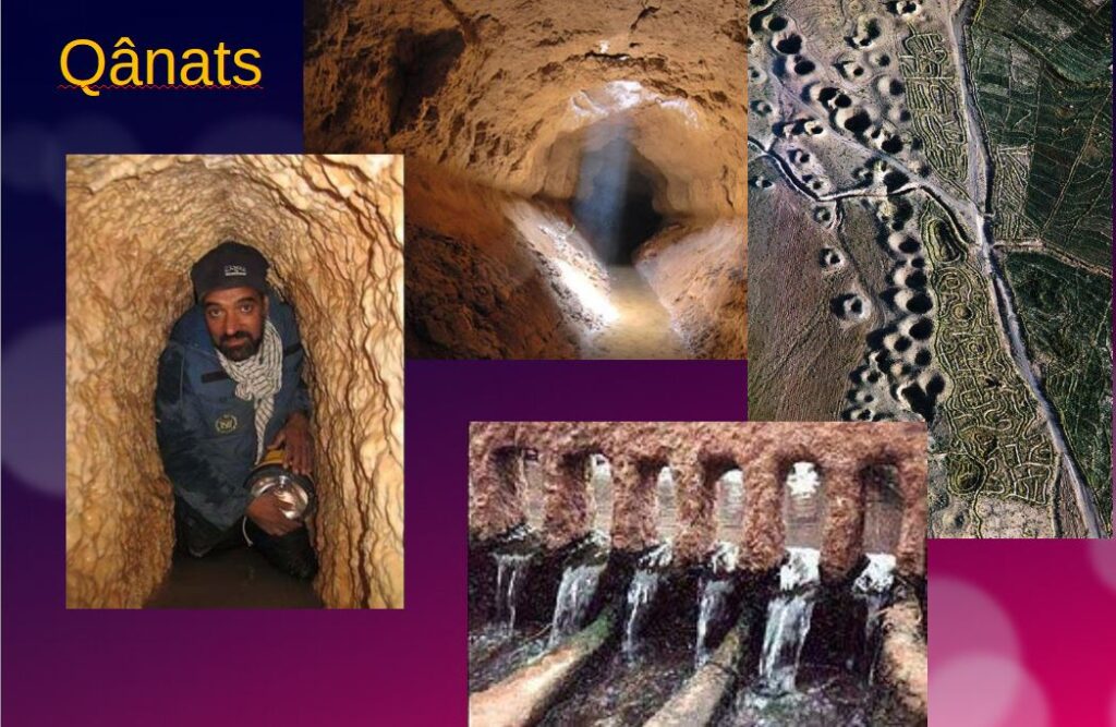
While each qanat is designed and supervised by a mirab (dowser-hydrologist and discoverer), building a qanat is a collective task that takes several months or years for a village or group of villages. The absolute necessity of collective investment in the infrastructure and its maintenance calls for a superior notion of the common good, an indispensable complement to the notion of private property that rains and rivers are not accustomed to respecting.
In North Africa, the management of water distributed by a khettara (the local name for qanâts) is governed by traditional distribution norms known as « water rights ».
Originally, the volume of water granted per user was proportional to the work involved in building the khettara, and translated into an irrigation period during which the beneficiary could use all the khettara’s flow for his or her fields. Even today, when the khettara has not dried up, this rule of water rights still applies, and a share can be bought or sold. The size of each family’s fields to be irrigated must also be taken into account
All of this demonstrates that good cooperation between man and nature can do miracles if man decides so.
Thank you for your attention and questions welcome!
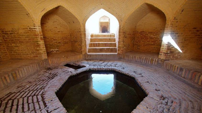


The challenging modernity of the Indus Valley Civilization

Get an easy-to-print pdf file of this article
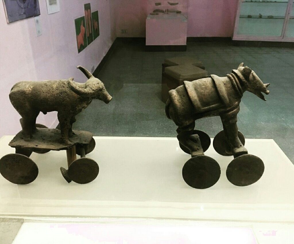
Karel Vereycken, Paris, France, January 2023
A major archaeological discovery has just been made in Israel in 2022: the first evidence of the use of cotton fibers in the Near East and among the oldest in the world, dating back nearly 7,000 years, was discovered by Israeli, American and German archaeologists during an archaeological excavation at Tel Tsaf, southeast of Beit She'an, in the Jordan Valley of Israel.

So far, the earliest available evidence of cotton fibers in the area was dated to a few hundred years later, to the late Chalcolithic (Copper Age) and Early Bronze Age (about 5,000 to 6,500 BCE) from the archaeological site of Dhuweila in eastern Jordan.
Discovered in 1940, the site of Tel Tsaf reveals its secrets. « Tsaf is characterized by an amazing preservation of organic materials, » said Professor Danny Rosenberg of the Zinman Institute of Archaeology at the University of Haifa. « Tel Tsaf was a kind of pole that concentrated important commercial activities and had established contacts with many other peoples, » Rosenberg believes. « There was massive storage capacity there to accommodate grain, enormous capacity if you compare it to other sites.
For example, the earliest evidence of the social use of beer drinking and ritual food storage has been found there. Rosenberg and the other researchers also found beads from contemporary Anatolia, Romania, Egypt and other parts of Africa; pottery from Iraq, Syria and Armenia; and the earliest copper and other metals found in the world.
“Wool Tree” and “Cotton Roads”
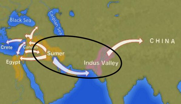
The cotton found in Israel, probably came from the Indus region—modern Pakistan/India—which was the only place in the world that had begun to domesticate cotton at that time before its cultivation appeared in Africa thousands of years later.
« What’s interesting about this early evidence of a link to such a distant region is that it comes from fibers – microscopic pieces of ancient yarn. We assume that these cotton fibers, found along with wool fibers and plant fibers, arrived at the site as part of fabrics or clothing, i.e., ancient textiles, » Rosenberg says.
In addition, cotton was not only used for clothing: « In the prehistoric era, textiles were involved in many areas of life, not only in clothing but also in hunting, fishing … This is much more important than just saying that what we found are pieces of clothing that were worn by the inhabitants of the area. This discovery tells us a lot about the economic practices of the area, » says Rosenberg.
Since cotton had never been grown in Tel Tsaf, it was a surprise for the researchers to find it, and they felt that its presence underscored the city’s importance as a global trading hub at the heart of what could be called, the « Cotton Roads » of those days.
Growing cotton poses major challenges: a moderate to tropical climate and vast amounts of water. Just to produce a single T-shirt and a pair of jeans (representing about 1 kg of cotton), no less than 20,000 liters of water are required! Which civilization can afford such a performance at the beginning of the 7th millennium BC?
The Indus Valley civilization (IVC)
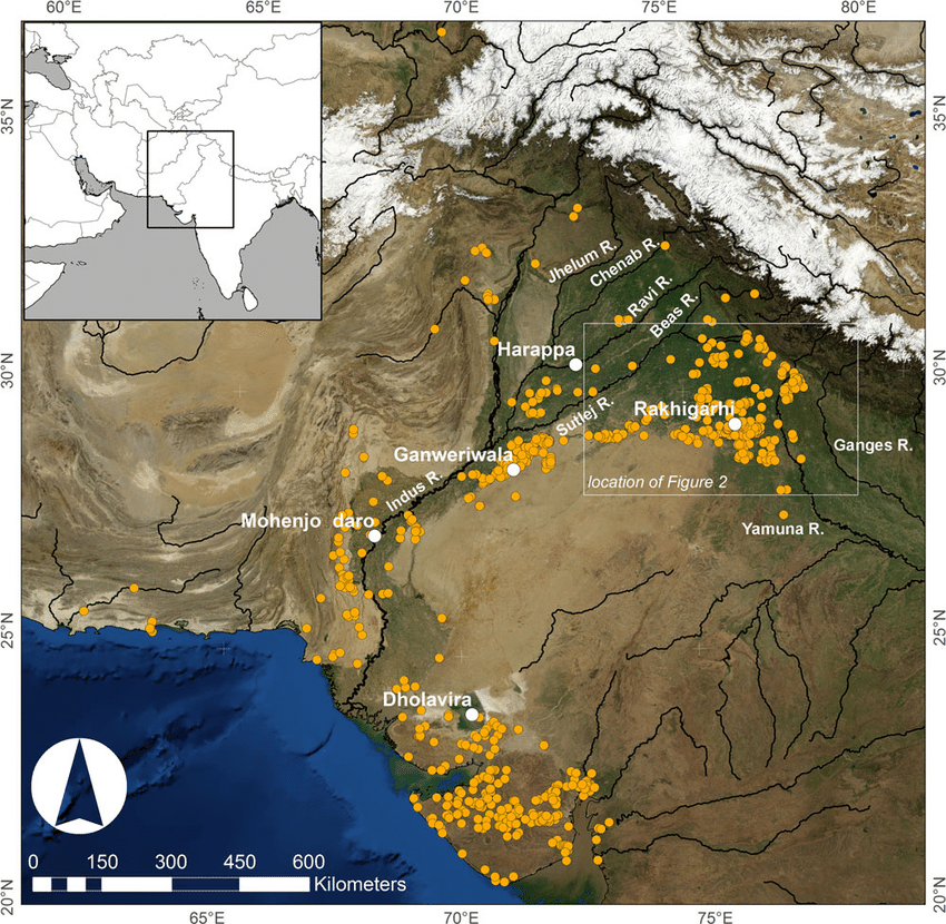
The term « Indus Valley Civilization » (IVC) refers to a vast cultural and political entity that flourished in the northern region of the Indian subcontinent between about 8000 and about 1900 BCE., a region that stretched from Baluchistan (Pakistan) in the west to Uttar Pradesh (India) in the east and from northeastern Afghanistan in the north to Gujarat (India) in the south.
In the absence of both literary sources and remnants of palaces and temples to confirm it, one cannot qualify this entity as a “Kingdom” or an “Empire”. Its modern name (IVC) derives simply from its location in the Indus Valley, but also goes under the name of the « Indus-Sarasvati civilization » or « Harappan civilization ». These last designations come from the river Sarasvati, mentioned in the Vedic sources, which flowed next to the Indus and which would have disappeared, and from the ancient city of Harappa (Punjab, Pakistan), discovered by the British in 1829, but deliberately left unexplored.
The rise of a great urban civilization in the Indus Valley, which reached its maturity around 2500-2400 BCE, was long considered a sudden and mysterious phenomenon. Today, a series of discoveries allows us to follow, from 7000 to 2500 BCE, a series of transformations and innovations whose cumulative effects, stimulated by the enlargement of the network of exchanges from 3000 BCE onwards, created the conditions for the development of an incredibly modern and prosperous urban civilization.
Enter Mehrgarh, the light of the world!
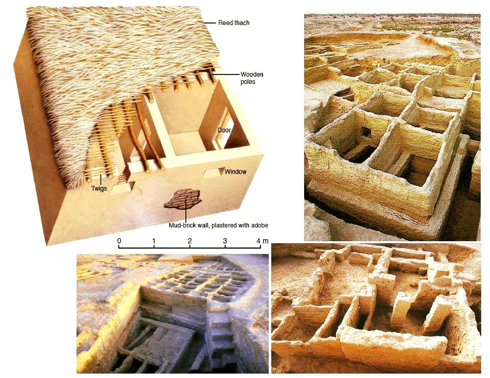
Since prehistoric times, the Indus region has been pioneering and rich in discoveries. As an example, for the Guinness Book of Records, although a case apart, the farming village of Mehrgarh (Baluchistan, Pakistan) which dates from the Neolithic (using only stones as tools) but can be considered as the key culture and city that lead humanity, as early as in the 8th millennia BCE, from the Stone Age into the Age of Copper.
The site is located on the principal route between what is now Afghanistan and the Indus Valley: this route was also undoubtedly part of a trading connection established quite early between the Near East and the Indian subcontinent.
Excavations in Mes Aynak (Afghanistan), where archaeologists are only beginning to find remnants of a 5,000-year-old Bronze Age site beneath the Buddhist level, including an ancient copper smelter, will undoubtedly shed new light on these relationships.
On the basis of a variety of well-documented archaeological finds, it has been established that “pre-Harrapan” Mehrgarh, made several historical breakthroughs for the benefit of humanity as a whole.
Mehrgarh gave the world:
- among the oldest traces of agriculture (wheat and barley) and breeding (cattle, sheep and goats) in South Asia ;
- the first breweries (with wheat and barley);
- the oldest reservoirs for irrigated agriculture and flood prevention;
- the oldest traces of cotton culture (6th millennium BCE);
- the oldest jewel, called the « Mehrgarh amulet » (6th millennium BCE), produced with the « lost wax » bronze casting technique ;
- the oldest bow drills (in green jasper) allowing to drill holes in lapis lazuli and carnelian;
- the very first traces of successfull dentistry practices (!) (9th millennium BCE); The inhabitants of Mehrgarh appeared to have developed an understanding of surgery and dentistry, as evidenced by the drilled teeth of some of the skeletons found at the site. Analysis of the teeth shows that prehistoric dentists worked to treat toothaches with drills made from flint heads. The work was so elaborate that even modern dentists are surprised at the efficiency with which the Mehrgarh « dentists » removed decaying tooth tissue. Among the remains, a total of eleven drilled crowns were found, with one example showing evidence of a complex procedure involving the removal of tooth enamel followed by carving of the cavity wall. Four of the teeth show evidence of decay associated with the drilled hole. None of the individuals with drilled teeth appear to have come from a special tomb or shrine, indicating that the oral health care they received was available to all.

Densely populated
Originally, the IVC was built around the fishy meanders of the Indus, a river nearly 3200 kilometers long that flows from the Himalayan mountains towards the Arabian Sea. Like the populations of other great river valleys, this society was seduced by the fertility of the land as well as by the possibility of using the Indus as a transportation route.
The IVC, whose prosperity rests largely on the increasingly systematic exploitation of the rich silt of the Indus, spread over an immense territory encompassing the entire Indus Valley and part of Indian Gujarat. It is necessary to add to the vast zone of distribution of the Indus civilization some Harappan « colonies » or outposts like Sutkagan Dor (Ballochistan, Pakistan), close to Gwadar on the edges of the sea of Oman, at the Iranian-Pakistani border, and the lapus lazuli mining town of Shortugai, close to Amu Darya river, at the Afghan-Tajik border, at nearly 1,200 kilometers of Mohenjo-daro, by far the largest IVC urban concentration.
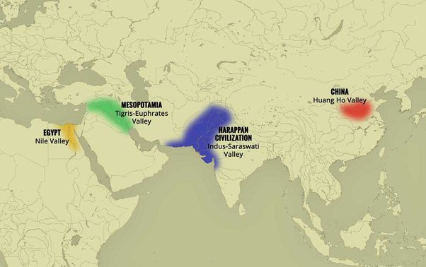
At its peak, this civilization was twice as large as the Old Kingdom of Egypt. With an area of 2.5 million square kilometers, it was at the time the largest civilization in the world: it included 5 million people, or 10 % of the world population at the time, much more than less older civilizations as Sumer (0.8 to 1.5 million people) or ancient Egypt (2 to 3 million).
To date, about 2,000 sites have been discovered in India, Pakistan and Afghanistan. Because of various wars and conflicts, only 10 % of the territory of these sites has been excavated and scientifically investigated. On the Indian subcontinent, the main centers of this civilization are Harappa (estimated 23,500 inhabitants) and Mohenjo-daro (est. 40,000 inhabitants) in Pakistan and Lothal, Dholavira and Kalibangan in India. In addition to trade relations with Mesopotamia and Iran, the Harappan city-states also maintained active trade relations with the peoples of Central Asia.
Agriculture, crafts and industry
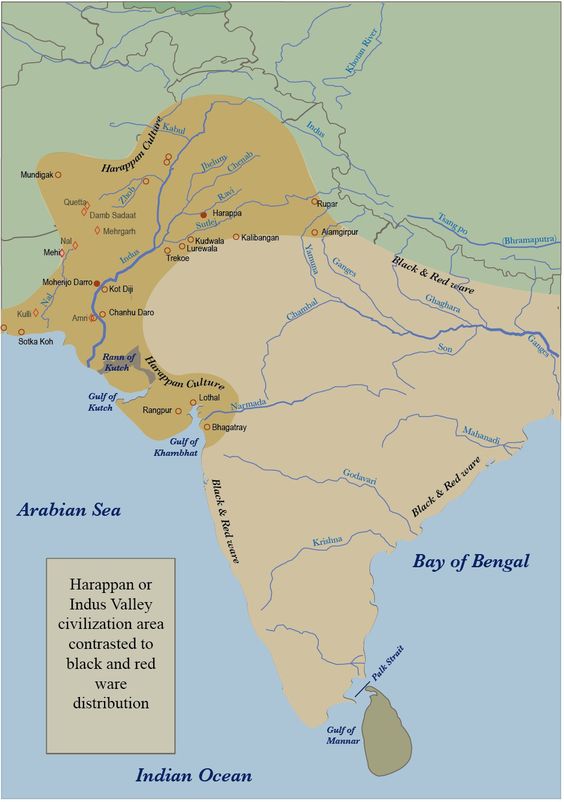
Agriculture, animal husbandry, industry, trade and commerce were the main source of income.
Agriculture was the main occupation of the people of the Indus Valley. They cultivated barley and wheat on a large scale (and made beer) but also other crops such as legumes, cotton, cereals, sesame, dates, mustard, melons, peas, etc.
There is no real evidence of rice, but a few grains of rice have been found in Rangpur and Lothal.
In the towns of Mehrgarh, Harappa, and Mohenjo-daro, there are remains of large granaries, suggesting that they produced more than they needed and physically stocked cereals and other food products in case of crop failure.
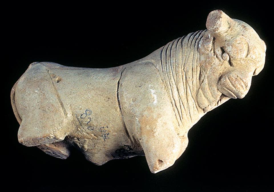
Animal husbandry was another major occupation. Seals suggest that they domesticated cows, buffalos, goats, sheep, pigs, etc. Camels and bullocks were also domesticated and used as beasts of burden. Camel bones have been found in large numbers at many sites, but there is no trace of them on the seals. During the excavation of Surkotado in Gujarat, India, the jawbone of a horse was found. Terracotta figurines representing a horse were found in Nausharo and Lothal.
The inhabitants of the Indus Valley were very skillful. They made ceramics, metal vessels, tools and weapons, weaved and spun, dyed and practiced other crafts with potter’s wheels. The weavers wore clothes made of cotton and wool. They knew leather, but there is no record of silk production.
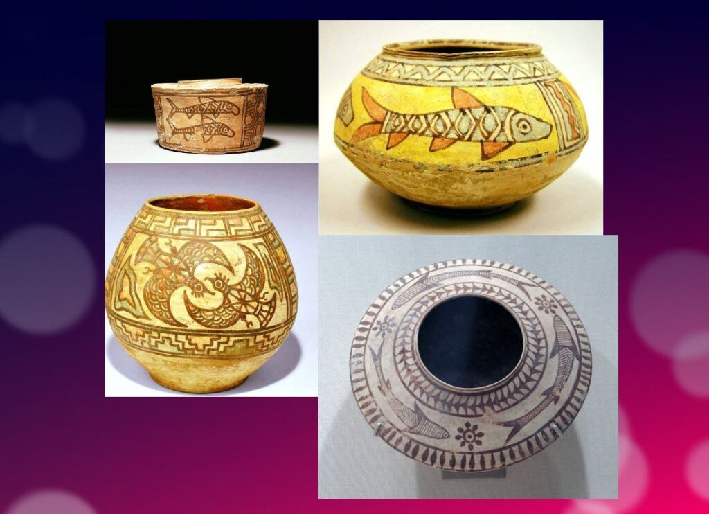
The inhabitants of this civilization originally came from the Bronze Age and used stone tools, but they soon excelled in the manufacture and processing of gold, silver, copper, lead and bronze, especially for artistic ornaments of great finesse.
Artisans made jewelry in Mohenjo-daro, Chanho-daro and Lothal. They used ivory and various precious stones such as carnelian, lapis lazulite, agate and jasper to make them. Shell work was also a thriving industry. Craftsmen in the coastal colonies used shells to make buttons for shirts, pendants, rings, bracelets, beads, etc.
To supply the production of these craft professions, they needed to import various raw materials. To produce bricks and ceramics, clay was available locally, but for metal they had to acquire it from abroad. Trade focused on importing raw materials to be used in Harappan city workshops, including minerals from Iran and Afghanistan, lead and copper from other parts of India, jade from China, and cedar wood floated down rivers from the Himalayas and Kashmir. Other trade goods included terracotta pots, gold, silver, metals, beads, flints for making tools, seashells, pearls, and colored gemstones, such as lapis lazuli and turquoise.
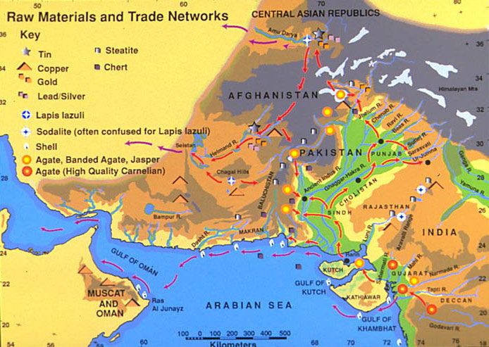
Ox carts were used to transport goods from one place to another. They also constructed barges used on the waterways along the Indus and its tributaries for transportation.
One of the ways historians know about the maritime trade network operating between the Harappan and Mesopotamian civilizations is the discovery of Harappan seals and jewelry at archaeological sites in regions of Mesopotamia, which includes most of modern-day Iraq, Kuwait, and parts of Syria. Long-distance sea trade over bodies of water—such as the Arabian Sea, Red Sea and the Persian Gulf—may have become feasible with the development of plank watercraft that were each equipped with a single central mast supporting a sail of woven rushes or cloth.
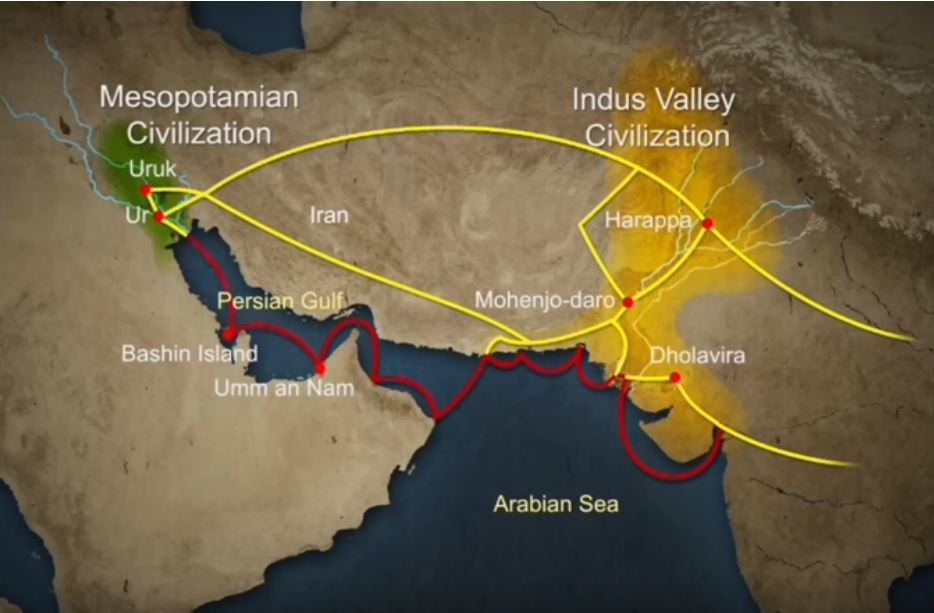
Historians have also made inferences about networks of exchange based on similarities between artifacts across civilizations.
Between 4300 and 3200 BCE, ceramics from the Indus Valley Civilization area show similarities with southern Turkmenistan and northern Iran. During the Early Harappan period—about 3200 to 2600 BCE—there are cultural similarities in pottery, seals, figurines, and ornaments that document caravan trade with Central Asia and the Iranian plateau.
The wonders of Mohenjo-daro
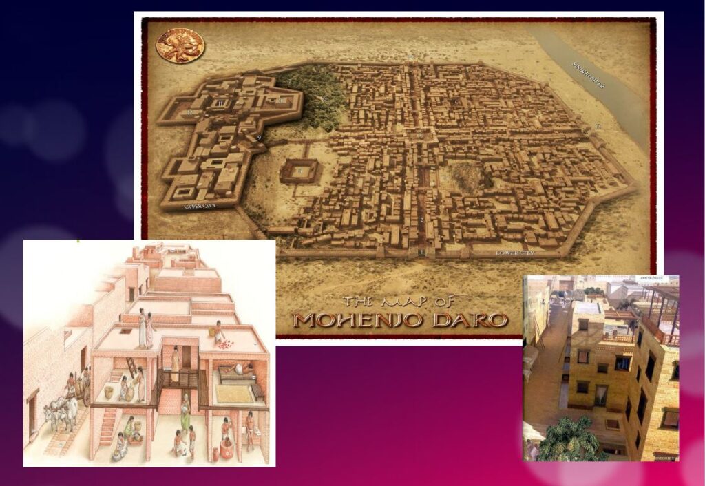
Sometimes referred to as the « Manhattan of the Bronze Age » for the grid pattern of the city plan, Mohenjo-daro (Sind, Pakistan) remained buried under meters of alluvial sediment until 1922.
A real metropolis made of baked bricks, it covers more than 200 hectares. Strictly squared, cut in two by a street of ten meters wide, divided from north to south by a dozen arteries drawn with the cord, and crossed from east to west by paved streets, Mohenjo-daro represents, by its strictly reflected urban framework, the model city of the Indus civilization. It could have accommodated up to 40,000 people!
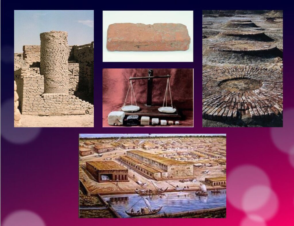
The Harappans were masters of hydraulic engineering, a “riparian” people working in river corridors practicing irrigated agriculture. They mastered both the shaduf (an irrigation tool used to draw water from a well), and windmills.
In the Harappan cities, the domestic and manufacturing areas were separated from each other.
The inhabitants, living in one-, two-, and sometimes three-story dwellings, seem to have been mainly artisans, farmers, and merchants. The people had developed the wheel, cattle-drawn carts, flat-bottomed boats large enough to carry goods, and perhaps also sailing. In the field of agriculture, they had understood and used irrigation techniques and canals, various agricultural implements, and had established different areas for livestock grazing and cultivation.
Seals and harrapan script
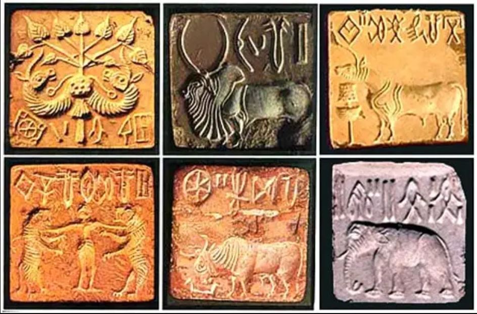
Among the thousands of artifacts found at the various sites are small soapstone seals just over one inch (3 cm) in diameter, used to sign contracts, authorize land sales, and authenticate the point of origin, shipment, and receipt of goods in long-distance trade. On each seal is a small text in Harappan, a language yet to be deciphered.
Among the thousands of artifacts found at the various sites are small soapstone seals just over one inch (3 cm) in diameter, used to sign contracts, authorize land sales, and authenticate the point of origin, shipment, and receipt of goods in long-distance trade.
Commercial contacts between the Indus and Sumer populations are well documented. Numerous seals from the Indus Valley have been discovered in Mesopotamia. On each seal, a small text in Harappean, a language that remains to be deciphered.
If 4,200 texts reached us, 60 % of them are seals or mini-tablets of stone or copper, engraved, and they comprise on average… only five signs! The longest text has 26 signs. The texts are always accompanied by the image of an animal, often a unicorn or a majestic buffalo. They were intended to mark goods, probably indicating the name of the owner or the recipient and a quantity or a year. Trying to decipher the Indus language is a bit like trying to learn French only from the labels on the food shelf of a supermarket!
The invention of sanitation
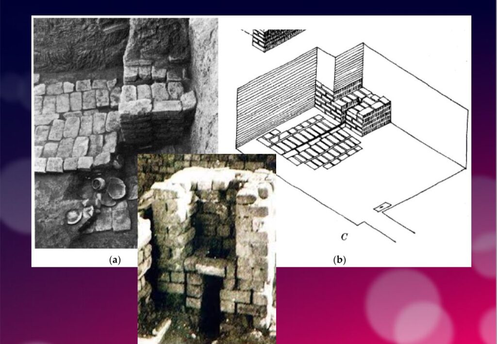
In addition to this particular attention that they paid to urban planning, the members of the Indus civilization also seem to have been pioneers of modern hygiene. Some cities, notably Mohenjo-daro, were equipped with small containers (dustbins) in which the inhabitants could deposit their household waste.
Anticipating our « all to the sewer » systems imagined in the 16th century by Leonardo da Vinci for the project envisaged by François I for the new French capital Romarantin, many cities had already public water supply and an ingenious sanitation system.
In many cities, including Mohenjo-daro, Harappa, Lothal and Rakhigari, individual houses or groups of houses were supplied with water from wells. This quality fresh water was used as much for food and personal hygiene (baths, toilets) as for the economic activities of the inhabitants.
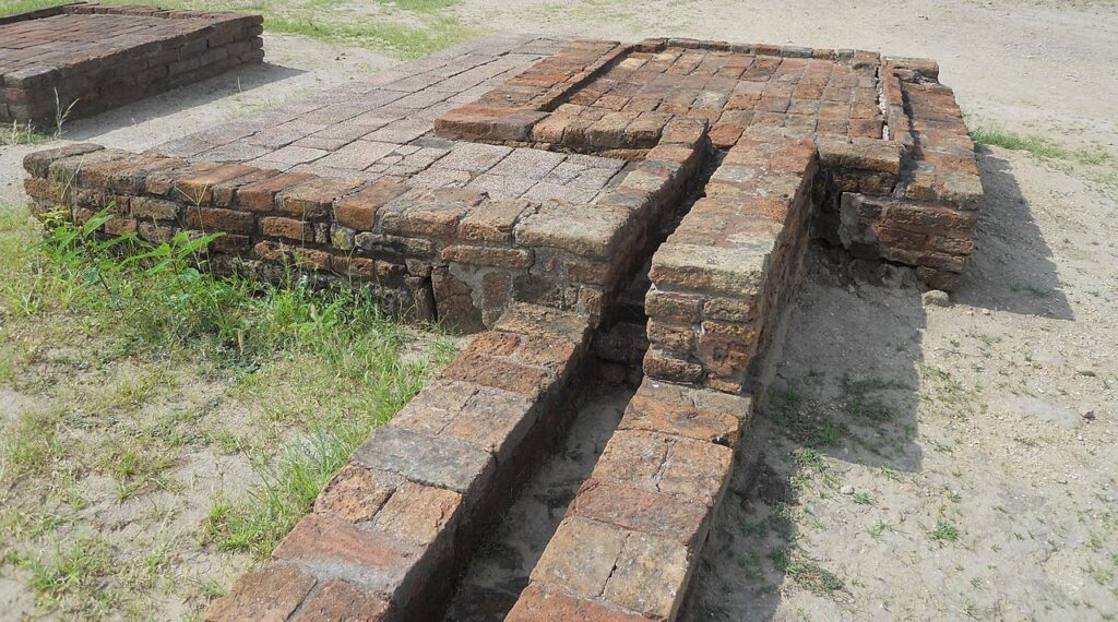
As an example, the sanitation system of the port city of Lothal (Gujarat, India) where many houses had a bathroom and private brick latrines. The wastewater was evacuated through a communal sewer system that led either to a canal in the port, or to a soaking pit outside the city walls, or to buried urns equipped with a hole allowing the evacuation of liquids, which were regularly emptied and cleaned.

Excavations at the Mohenjo-daro site have also revealed the existence of no less than 700 brick water wells, houses equipped with bathrooms and individual and collective latrines. Toilets were an essential element. However, early archaeologists erroneously identified most toilets as post-cremation burial urns or simple cesspools. Many buildings in the city were two or more stories high. Water from the roof and bathrooms of the upper floors was channeled through closed clay pipes or open troughs that emptied, if necessary via the toilets, into the covered sewers underneath the paved street.
This extraordinary achievement is confirmed by a 2016 scientific study, entitled « The Evolution of Toilets Around the World Across the Millennia, » which reports that,
The earliest multi-flush toilets connected to a sophisticated sewage system that have been identified so far were found in the ancient cities of Harappa and Mohenjo-Daro in the Indus Valley, dating from the middle of the third millennium BC. Nearly every dwelling unit in Harappa, Mohenjo-Daro, and Lothal was equipped with a private bath-toilet area with drains to carry dirty water into a larger drain that emptied into the sewer and drainage system.
Till now, it are the Minoan (Crete) civilization and China that have been credited for the first use of underground clay pipes for sanitation and water supply. In the Cretan capital Knossos, there was a well-organized water system to bring in clean water, to evacuate wastewater and to provide storm sewers for overflow in case of heavy rains.
In Knossos existed also one of the earliest uses of flush toilets, dating back to the 18th century BCE. The Minoan civilization had stone sewers that were periodically cleaned with clean water. Crete, of course, was a large provider of Copper ore for the entire world in Antiquity and had vast international trade connections.
Religious and cultural worldview
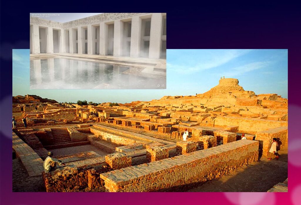
In the IVC, fertility rituals were probably observed in order to promote a full harvest as well as for women’s pregnancies, as evidenced by a number of figurines, amulets and statuettes with female form.
It is thought that the people, like the Dravidians who some believe were the origin of the Indus Civilization, worshiped a “mother goddess” and possibly a male companion represented as a horned figure in the company of wild animals.
The « Great Bath » at Mohenjo-daro would have been used for purification rites related to religious belief, but it could just as easily have been a public pool for recreation. Our knowledge of the religious beliefs of this culture remains in the realm of mere hypothesis.
The title of the famous statue of the « Priest-King » found at Mohenjo-daro is misleading, as there is no evidence that it is a king or a priest, and it may be a simple cotton trader…
Apart from pottery, certain types of elementary weapons (spearheads, axes, arrows, etc.) and certain tools for practical purposes, two types of artifacts give us cultural clues about Harappean society.
First, some figurines, which we try to interpret as devotional objects, seem to be simple toys. For others, they are clearly toys, notably animals (oxen, buffaloes, elephants, goats and even a simple hen), made of bronze or terracotta, mounted on small carts with wheels.
Second, among other objects expressing a high level of sensitivity and consciousness, a series of masks, some of which seem inspired by Mongolian masks.
These masks are clearly intended to serve comic or tragic representations and remind us of the ancient masks that have come down to us from classical Greece.
Older than Sumer and Egypt?
Archaeological excavations of the IVC got off to a late start, and it is now believed that some of the achievements and « firsts » attributed to Egypt ( – 3150 BC) and Mesopotamia ( – 4500 BC) may in fact belong to the inhabitants of the Indus Valley civilization.
In May 2016, the report published by a team of researchers from IIT Kharagpur, Institute of Archaeology, Deccan College Pune, Physical Research Laboratory and Archaeological survey of India (ASI), published by the journal Nature, shattered a number of “facts” that were considered unshakeable certainties.
Until now, the 900 years of the « mature » phase of the IVC was dated as ranging from 2800 to 1900 BCE. However, the aforementioned Indian study indicates that this civilization was much older than previously thought – it is at least 8,000 years old!
To determine the age of this civilization, researchers dated pottery using a technique called optically stimulated luminescence (OSL) – and found it to be nearly 6,000 years old, the oldest pottery known to date.
Other artifacts have been dated to 8,000 years ago. The results come from a major site excavated at Bhirrana (Haryana, India) that shows the preservation of all cultural levels of this ancient civilization, from the pre-Harappan phase through the Early Harappan to the Mature Harappan period. Bhirrana was part of a high concentration of sites along the mythical Vedic river « Saraswati », now dried up, an extension of the Harki-Ghaggar River in the Thar Desert.
The submerged cities of the Gulf of Khambhat
These new dates converge with the discovery, in January 2002, of ruins of submerged cities in the Gulf of Khambhat (formerly Cambay), off the coast of the state of Gujarat in northwest India.
It is the oceanographers of the National Institute of Ocean Technology (NIOT) of Madras who made this discovery. The team was surveying the muddy sea 30 km off the coast of the state of Gujarat, in the Gulf of Khambhat, to measure the levels of marine pollution. As a routine measure, they recorded acoustic images of the ocean floor.

It was only several months later, while analyzing the data, that the team realized that they had, without knowing it, obtained images of the ruins of a huge city, sunken 40 meters below sea level. And, at the end of January 2002, after having spent weeks to dredge the site and to bring up more than 2 000 objects, the team of the NIOT was able to make extraordinary revelations.
The ruins stretch for 9 km along the banks of an ancient river, and the remains of a dam can be distinguished. The sunken city shares striking similarities with the sites of the Indus civilization. One of the buildings, the size of an Olympic swimming pool, with collapsed steps, recalls the Great Bath of Mohenjo-daro. Another rectangular monument, 200 m long and 45 m wide, is as large as the acropolis discovered at Harappa. The team of NIOT also glimpsed another building, a kind of granary, made of mud bricks, 183 m long. Near these monumental installations, rows of rectangular buildings that resemble the foundations of ruined houses can be seen, and even a drainage system and roads. On another visit to the site, the team recovered polished stone tools, ornaments and figurines, pottery debris, semi-precious stones, ivory and the fossilized remains of a human spine, jaw and tooth. But the team was not at the end of its surprises.
It sent samples of a fossilized log to two major Indian laboratories specializing in dating methods: the Birbal Sbahni Institute of Paleobotany (BSIP) in Lucknow and the National Geophysical Research Institute (NGRI) in Hyderabad. The BSIP dated it to 5500 BCE, while the NGRI dated the sample much earlier, probably to 7500 BCE.
This dating would make Khambhat the oldest site discovered in India. According to some, this discovery could mark the end of the theory according to which urbanization spreads from Asia from the west towards the Indus. This dating caused intense controversy. Archaeologist G. Possehl points out that there is no reason to believe that the fossilized piece of wood belongs to the ruins of the ancient city, given the strong sea currents in the region, it could have come from elsewhere. NIOT’s team acknowledged the validity of these criticisms and assured that other objects would be subjected to dating methods. It is also a question of understanding how this city was sunk and how it ended up 30 km from the coast.
Harsh Gupta, geologist, thinks that it is a gigantic earthquake which caused the destruction of the city. We are in a high seismic risk area, and the 2001 Bhuj earthquake showed the vulnerability of the region to such phenomena. However, the priority is to definitively establish the age of the sunken city and prove it to be the most exciting discovery of this century.
Historical cradle of textiles

In his book Empire of Cotton, A Global History (2015) Sven Beckert traces in depth the development of what the ancients, intrigued by its resemblance to the feel of wool, called the « wool tree. » While this plant grows in both temperate and tropical climates, it needs an abundance of moisture to thrive fully, which consigns its cultivation to naturally and then artificially irrigated river valleys.
According to the author, « The farmers of the Indus Valley were the first to spin and weave cotton. In 1929, archaeologists found fragments of cotton textiles at Mohenjo-Daro, in present-day Pakistan, dating from 3250 to 2750 BCE. Cotton seeds found in nearby Mehrgarh have been dated to 5000 BCE. Literary references also attest to the antiquity of the cotton industry in the subcontinent. The Vedic scriptures, composed between 1500 and 1200 BCE., allude to the spinning and weaving of cotton…”
Historically, the discovery of the first cotton fragments was made at Mohenjo-daro during an expedition led by Sir John Marshall, Director General of the Archaeological Survey of India from 1902 to 1928. In his book on Mohenjo-daro and the Indus Civilization, Sir Marshall relates that fragments of cloth were wrapped around a silver perfume pot and a salt shaker.
Early forms of Self-government?
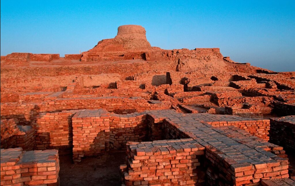
The fact remains that the political organization of the Indus cities escapes the experts. Because contrary to the Mesopotamian and Egyptian civilizations, the researches realized on the sites of the valley of the Indus did not bring to light any temple or palace of scale. There is no proof either of the existence of a permanent army…
Of what to wonder about the presence or not of a political power. Panic among British archaeologists and geopoliticians always inclined to project their own colonial ideology of aristocratic castes on the rest of the world.
In reality, each city seems to have had its own governor, or citizen council coordinating with other urban areas, all adhering to a number of common principles considered mutually beneficial.
This “Coincidence of Opposites”, of great diversity with perfect similarity, intrigues expert John Keay:
What amazed all those pioneers, and what remains the distinguishing characteristic of the several hundred Harappan sites now known, is their apparent similarity: ‘Our overriding impression is of cultural uniformity, both throughout the several centuries during which Harappan civilization flourished, and over the vast area it occupied.’ The ubiquitous bricks, for example, all have standardized dimensions, just as the stone cubes used by the Harappans to measure weight are also standardized and based on the modular system. The width of roads conforms to a similar module; thus, streets are generally twice as wide as side streets, while main arteries are two or one and a half times as wide as streets. Most of the streets excavated so far are straight and run north to south or east to west. The city plans thus conform to a regular grid pattern and seem to have retained this arrangement through several phases of construction.
Hence, given the existence of a unified system of weights and measures; given the similarity of urban organization as well as the standardization of the size of terracotta bricks for hundreds of cities, it is therefore simply impossible that the every man for himself reigned supreme.
Cradle of democracy?
In 1993, in an article entitled « The Indus Valley Civilization, Cradle of Democracy? », published by the UNESCO Courier, the internationally renowned Pakistani archaeologist and museologist, Syed A. Naqv, who has been fighting for the preservation of the Mohenjo-daro site, attempted to answer the question.
In all the highly developed civilizations of the past – Mesopotamia, the Nile Valley, Anatolia, China – the pervasive influence of an imperial authority can be felt, providing patronage for the arts and directing the evolution of society. A close examination of such an imperial authority over this civilization, which flourished some 5,000 years ago and covered almost twice the area of the civilizations of Mesopotamia and the Nile combined seems to belie the presence of an authoritarian regime, the Indus civilization had a well-disciplined way of life, civic controls and organizational system which could only have stemmed from the kind of “rule by the people” that was exercised in some Greek city-State some 2,000 years later. Did Greece give birth to democracy, or did Greece simply follow a practice developed earlier?
Although there are no large structures acting as centers of authority,
the discoveries made so far suggest that the rule of law extended over an area measuring roughly 1,600 kilometers from the north to the south and more that 800 kilometers from east to west. The main argument in support of this thesis is the existence of well-established norms and standards which would have required the consensus of the people if they had not been imposed by an authoritarian regime. It is impossible to ignore the evidence furnished by the perfect planning of the great city of Mohenjo-daro and the use in its construction of standard-sized bricks 27.94 cm long, 13.96 cm wide and 5.71 cm thick.
In the two large cities of Mohenjo-daro and Harappa, about 600 km distant,
the grid pattern of the street layout uncovered by the archaeological excavations shows that great attention was paid to the security of the inhabitants and suggests the existence of a highly developed and well-monolithic system of civic control.
The same is true of the highly sophisticated sewage system and the existence of
a virtually complete series of highly polished stone weights. Their shapes are cubical, half-cubical, cylindrical and spherical, and very few of them are reported to be defective. They provide yet another proof of a civic authority maintaining consistent commercial standards.
It is not possible to conclude that such « a philosophical conception of democracy exists until the Harappan script is deciphered and written evidence is provided. But the signs are there, and further research in this direction may well establish that ‘government by the people’ originated in the Indus Valley, » the author concludes.
Finally, since this agricultural people, who knew the use of the spears and the arrows but didn’t leave any trace of a major military activity – few weapons nor fortifications with exclusively defensive purpose have been found – , many observers agree to say that this society could have known the longest period of peace of the history of the humanity.
Decay and fall
In two of his books, the Timaeus and the Critias, the Greek philosopher Plato tells the story « certainly true, although strange » of a maritime people with incomparable power: the Atlantes whose civilization and capital he describes in great detail.
Starting 10,000 years before our era from an island located beyond the columns of Hercules, the Atlanteans would have ended up dominating the whole of Africa and Western Europe.
In a passage which is not without recalling the type of political organization which could exist in Mohenjo-daro, Critias specifies that Atlantis was then inhabited « by the various classes of men who deal with the trades and agriculture. The warriors, separated from the beginning by divine men, lived separately, possessing all that was necessary for their existence and that of their children. Among them, there were no particular fortunes; all goods were in common: they demanded from the other citizens nothing beyond what they needed to live, and fulfilled in return all the obligations that our talk of yesterday attributed to the defenders of the fatherland as we conceive them. »
Perhaps speaking metaphorically, Plato states that initially virtuous, the Atlantis civilization would have sunk into excess, arrogance and corruption to the point of being chastised by Poseidon himself for having embarked on one war too many, this time against Athens. And « in the time lapse of a single terrible day and night (…) the island of Atlantis sank into the sea and disappeared ».
At the historical level, the sudden decline of the Indus civilization around 1900 BC remains a mystery. Historians point to aspects of Minoan civilization (Crete) showing astonishing similarities with the IVC, especially watermanagement and early sewer systems in Knossos, lost wax broze casting techniques and bull fighting.
A few traces of fire and destruction, as well as forty skeletons wounded with knives and found without burial at Morenjo-daro, first suggested an invasion by Aryan peoples from Central Asia or the Iranian plateau. « This theory has now been abandoned. We have indeed found no effective trace of massacres or violence on the sites of the Indus Valley, or furniture that could be associated with such populations, » says Aurore Didier, researcher at the CNRS and director of the Indus mission.
Another hypothesis, an inability to strengthen its resilience to climatic chaos. « The samples taken in the northwest of India have shown that the climate there has changed significantly about 2000 years before our era. It is reported that this was also the case in Mesopotamia. « It became more like the dry and arid climate of today, which disrupted the cultivation and, in fact, the trade of the Indus civilizations. The ensuing socio-economic upheaval may have led to the decline of these societies. This hypothesis is the most commonly accepted to date, » says the archaeologist.
The inhabitants would have left their valleys become infertile to migrate to the plains of the Ganges. « This was accompanied by a change in livelihood strategies. The Indus civilization gradually converted to summer cereal crops based on rice and millet, two commodities more able to withstand these new climatic conditions and requiring, for rice, the development of irrigated agriculture, » says Aurore Didier. « It has also forged links with new trading partners.”
So there is no reason to talk about the « collapse » of a society in the sense of collapsologists. It is rather a gradual adaptation to the evolution of the environment, spread over several centuries.
As the excavations of the sites of the Indus Valley civilization continue, new information will undoubtedly contribute to a better understanding of its history and development. Any additional knowledge of this common civilizational legacy will serve in the future as a basis for fraternal cooperation between Pakistan, India and Afghanistan and others.
In the meantime, instead of trying to copy the barbaric « models » of the Mongolian Empire, the Roman Empire or the British Empire, the « elites » of the transatlantic world would do better to draw inspiration from a magnificent civilization that seems to have prospered for 5,000 years without perpetual wars and massacres, but simply thanks to a good mutual understanding, at the national level, between citizens, and thanks to mutually beneficial cooperation with the overriding majority of its distant partners.
The Indus Valley Civilization’s modernity, capable of offering food, shelter, water and sanitation to all, in a mirror image, shows all of us living in the present, how backwards we became.
Persian Qanâts and the Civilization of Hidden Waters

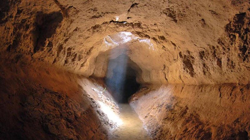
By Karel Vereycken, July 2021.

By Karel Vereycken, July 2021.
At a time when old diseases make their return and new ones emerge worldwide, the tragic vulnerability of much of humanity poses an immense challenge.
One wonders whether to laugh or cry when international authorities trumpet without further clarification that to stop the Covid-19 pandemic, “all you have to do” is “wash your hands with soap and water”!
They forget one small detail: 3 billion people do not have facilities to wash their hands at home and 1.4 billion have no access to either water or soap!
Yet, since the dawn of time, mankind has demonstrated its capacity to mobilize its creative genius to make water available in the most remote places.
Here is a short presentation of a marvel of such human genius, the “qanâts”, an underground water conveyance system dating from the Iron Age. Probably of Egyptian origin, it was deployed on a large scale in Persia from the beginning of the 1st millennium BC.

The qanât or underground aqueduct

Sometimes called “horizontal drilling”, the qanât is an underground aqueduct employed to draw water from a water table and convey it by simple gravitational effect to urban settlements and farmland. The word qanât is an old Semitic word, probably Accadian, derived from a root qanat (reed) from which come canna and canal.
This “drainage gallery”, cut into the rock or built by man, is certainly one of the earliest and most ingenious inventions for irrigation in arid and semi-arid regions. The technique offers a significant advantage: by conveying water through an underground conduit, contrary to open air canals, not a single drop of water is wasted by evaporation.
Oases’ are NOT natural phenomena. All known oases are man-made. It is the qanât technique that allows man, in a given geographic configuration, to create oases in the middle of the desert, when a water table is close enough to the ground level or at a site close to the bed of a river lost in the sands of the desert.
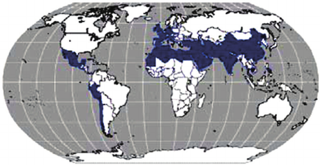
Copied and expanded by the Romans, the qanât technique was carried across the Atlantic to the New World by the Spaniards, where many such underground canals still function in Peru and Chile. In fact, there are even Persian qanâts in western Mexico.
While today this three thousand year old technique may not be appropriate everywhere to solve current water scarcity problems in arid and semi-arid regions, it has much to inspire us as a demonstration of human genius at its best, that is, capable of doing a lot with a little.
The oases of Egypt
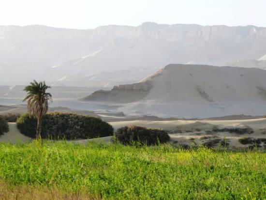
Today, 95% of the Egyptian population prospers on only 5% of its territory, mainly around the Nile delta. Hence, from the earliest days of Egyptian civilization, irrigation and water storage techniques for the Nile floods were developed in order to conserve this silty, nutrient-rich water for use throughout the year.
The river water was diverted and transported by canals to the fields by gravity. Since water from the Nile did not reach the oases, the Egyptians used the gushing water from the springs, which came from the large aquifer reserves of the western desert, and conveyed it to the fields by irrigation canals.
One of the fruits of this attempt to “conquer the desert” was a sustained habitation of the Dakhleh oasis throughout the Pharaonic period, explicable not only by a commercial interest on the part of the Egyptian state, but also by the new agricultural perspectives it offered.
Roman aqueducts
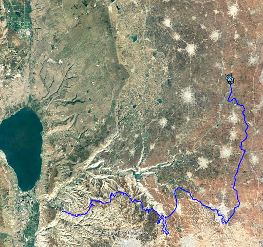
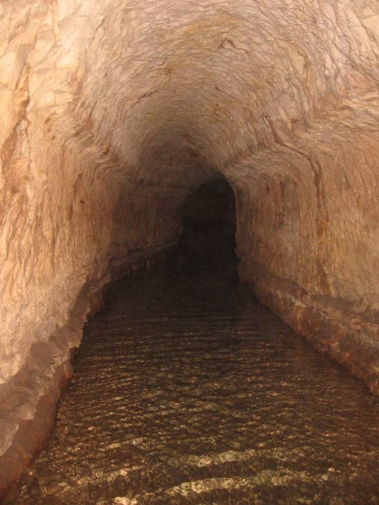
Closer to us in time, the Qanât Fir’aun (The Watercourse of the Pharaoh) also known as the aqueduct of Gadara, a city today in Jordan. As far as we know, this 170 km long structure, depending on the geography, combines several bridge-aqueducts (of the same type as the Gard aqueduct in France) and 106 km of underground canals using the Persian qanât technique. It is not only the longest but also the most sophisticated aqueduct of antiquity, and the fruit of a years of hydraulic engineering.
In reality, the Romans, hiring persian water experts, did nothing more than terminate in the 2nd century an ancient project designed to supply water to the “Decapolis”, a collaborative group of ten cities founded by Greek and Macedonian settlers under the Seleucid king Antiochos III (223 – 187 BC), one of the successors of Alexander the Great.
These ten cities were located on the eastern border of the Roman Empire (now in Syria, Jordan and Israel), united by language, culture and political status, each with a degree of autonomy and self-rule. Its capital, Gadara, was home to more than 50,000 people and known for its cosmopolitan atmosphere, its own university attracting scholars, writers, artists, philosophers and poets. But this rich city lacked something existential : an abundance of water.
The Gadara qanat made the difference. “In the capital alone, there were thousands of fountains, watering holes and baths. Wealthy senators cooled themselves in private pools and decorated their gardens with cooling caves. The result was a record daily consumption of more than 500 liters of water per capita,” explains Matthias Schulz, author of a report on the aqueduct in Spiegel Online.
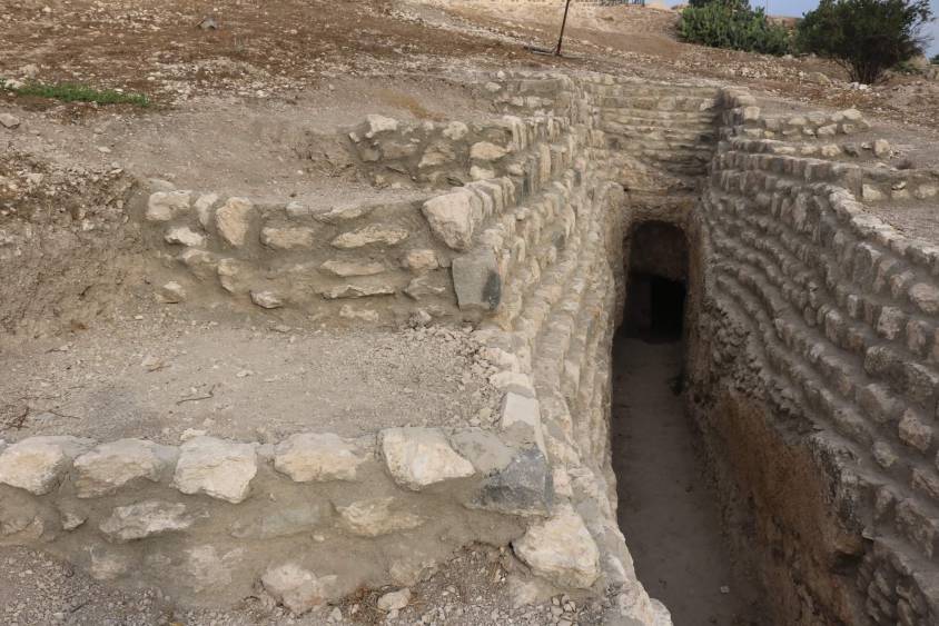
Persia
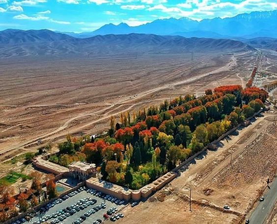
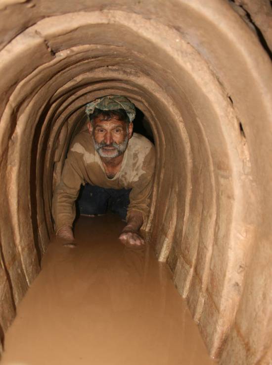
We all admire the roman aqueducts. But few of us are aware that the Romans only adapted the technique of the qanâts developed much earlier in Persia.
Indeed, it was under the Achaemenid Empire (around 559 – 330 BC.), that this technique spread slowly from Persia to the east and the west. Many qanâts can be found in North Africa (Morocco, Algeria, Libya), in the South East Asia (Iran, Oman, Iraq) and further east, in Central Asia, from Afghanistan to China (Xinjiang), via India.
The development of these “draining galleries” is attested in different regions of the world under various names: qanât and kareez in Iran, Syria and Egypt, kariz, kehriz in Pakistan and Afghanistan, aflaj in Oman, galeria in Spain, kahn in Balochistan, kanerjing in China, foggara in North Africa, khettara in Morocco, ngruttati in Sicily, bottini of Siena, etc.
Historically, the majority of the populations of Iran and other arid regions of Asia or North Africa depended on the water provided by the qanâts; their construction lifted entire areas to a higher “economic platform”, made deserts habitable and opened new land for agriculture. The map of demographic expansion followed the trail of the development of this new higher platform.
In his article « Du rythme naturel au rythme humain : vie et mort d’une technique traditionnelle, le qanât » (From natural rhythm to human rhythm: the life and death of a traditional technique, the qanât), Pierre Lombard, a researcher at the French CNRS, points out that this is not an artisanal and marginal process:
“Until a few years ago, the importance of the ancestral technique of qanât was sometimes ignored in Central Asia, Iran, Syria, and even in the countries of the Arabian Peninsula. For example, the Public Authority for Water Resources of the Sultanate of Oman estimated in 1982 that all the qanâts still in operation conveyed more than 70 % of the total water used in that country and irrigated nearly 55% of the cereal lands. Oman was still one of the few states in the Middle East to maintain and sometimes even develop its qanât network; this situation, apart from its longevity, does not appear to be exceptional. If one turns to the edges of the Iranian Plateau, one can note with Wulff (1968) the obvious discrepancy between the relative aridity of this area (between 100 and 250 mm of annual precipitation) and its non-negligible agricultural production, and explain it by one of the densest networks of qanâts in the Middle East. It can also be recalled that until the construction of the Karaj dam in the early 1960s, the two million inhabitants of Tehran at that time consumed exclusively the water brought from the Elbourz foothills by several dozen regularly maintained qanâts. Finally, we can mention the case of some major oases in the Near and Middle East (Kharga in Egypt, Layla in Saudi Arabia, Al Ain in the United Arab Emirates, etc.) or in Central Asia (Turfan, in Chinese Turkestan) that owe their vast development, if not their very existence, to this remarkable technique.”
On the website ArchéOrient, the French archaeologist Rémy Boucharlat, Director of Research Emeritus at the CNRS, an Iran expert, explains:
“Whatever the origin of the water, deep or not, the technique of construction of the gallery is the same. First, the issue is to identify the presence of water, either its going underground near a river, or the presence of a water table under a foothill, which requires the science and experience of specialists. A motherwell will be dug to reach the top of the water table, indicating at which depth the [horizontal] gallery should be drilled. It’s slope must be very small, less than 2‰, so that the flow of water is calm and regular, and conduct the water gradually to the surface area, according to a gradient much lower than the slope of the foothill.
“The gallery is then dug, not starting from the mother well because it would be immediately flooded, but from downstream, from the point of arrival. The conduct is first dug in an open trench, then covered, and finally gradually sinks into the ground in a tunnel. For the evacuation of soil and ventilation during excavation, as well as to identify the direction of the gallery, shafts are dug from the surface at regular intervals, between 5 and 30 m depending on the nature of the land ».
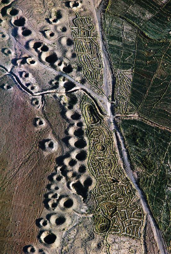
In April 1973, Lyndon LaRouche’s friend, the French-Iranian professor and historian Aly Mazahéri (1914-1991), published his translation from Arab into French of “The Civilization of Hidden Waters”, a treatise on the exploitation of underground waters composed in the year 1017 by the Persian hydrologist Mohammed Al-Karaji, who lived in Baghdad. (Translated in English in 2011)
After an introduction and general considerations on geography, natural phenomena, the water cycle, the study of terrain and the instruments of the hydrologist, Al-Karaji gives a highly precise technical outline of the construction and maintenance of qanâts, as well as legal considerations respecting their management and maintenance.
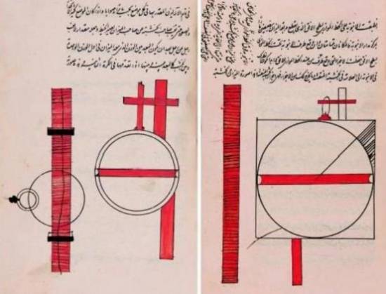
In his introduction to Al-Karji’s treatise, Professor Mazaheri emphasizes the role of the Iranian city of Merv (now in Turkmenistan). This ancient city, he says, was part of
“the long series of oases extending at the foot of the northern slope of the Iranian plateau, from the Caspian to the first foothills of the Pamirs. There, between the geological extension of the Caspian towards the East, there is a strip of arable land, more or less wide, but very fertile. Now, to exploit it, a lot of ingenuity is needed: where, for example in Merv, a big river, such as the Marghab, coming from the glaciers of the central East-Iranian massif, crosses the chain, it is necessary to establish dams, above the strip of arable land, without which, the ‘river’, divided into several dozens of arms, rushes under the sands. Elsewhere, and it is almost all along the northern slope of the chain, one can create artificial oases, by bringing the water by underground aqueducts.” (p. 44)
“The construction of dams and underground aqueducts are among the most interesting legacies of their (the ancient Persians) irrigation techniques (…) Long before Islam, the Persian hydrologists had built thousands of aqueducts, allowing the creation of hundreds of villages, dozens of cities previously unknown. And very often, even where there was a river, because of the insufficiency of this one, the hydronomists had brought to light many aqueducts allowing the extension of the culture and the development of the city. Naishabur was such a city. Under the Sassanids, and later under the Caliphs, an important network of aqueducts had been created there, so that the inhabitants could afford the luxury of owning a ‘’bathing room’ in the basement, at the level of the aqueduct serving the house.”

Let us recall that most Persian scholars, including the famous mathematician Al-Khwarizmi, not suffering from today’s hyper-specialization that tends to curb creative thinking, excelled in mathematics, geometry, astronomy and medicine as well as in hydrology.
Mazaheri confirms that this “civilization of underground waters” spread well beyond the Iranian borders:
“Already, under the [Umayyad] Caliph Hisham (723-42), Persian hydronomists built aqueducts between Damascus and Mecca (…) Later, Mecca suffering from lack of water, Zubayda, the wife of Hâroun Al-Rachîd, sent Persian hydronomists there who endowed the city with a large underground aqueduct. And each time the latter was silted up, a new team left Persia to restore the network: such repairs took place periodically under Al-Muqtadir (908-32), under Al-Qa’im (1031-1075), under Al-Naçir (1180-1226) and, at the beginning of the fourteenth century, under the Mongol prince Emir Tchoban. We would say the same of Medina and the stages on the pilgrimage route, between Baghdad and Mecca, wherever it was possible to do so, hydronomic works were undertaken and ‘underground aqueducts’ were created.
“Hydronomy is a highly demanding skill. To practice it, it is not enough to have mathematical knowledge: decadal calculus, algebra, trigonometry, etc., it is necessary to spend long hours in the galleries at the risk of dying by flooding, landslide or lack of air. It is necessary to have an ancestral instinct of ‘dowser’.”
The annual rainfall in Iran is 273 mm, which is less than one third of the world’s average annual precipitation.
The temporal and spatial distribution of precipitation is not uniform; about 75% occurs in a small area, mainly on the southern coast of the Caspian Sea, while the rest of the country does not receive sufficient rainfall. On the temporal scale, only 25% of the precipitation occurs during the plant growing season.
7,7 x the circonférence of the Earth

Still in use today in Iran, qanâts currently supply about 7.6 billion m3 of water, close to 15% of the country’s total water needs.
Considering that the average length of each qanât is 6 km in most parts of the country, the total length of the 30,000 qanât systems (potentially exploitable today) is about 310,800 km, which is about 7.7 times the circumference of the Earth or 6/7th of the Earth-Moon distance!
This shows the enormous amount of work and energy applied to build the qanâts. In fact, while more than 38,000 qanâts were in operation in Iran till 1966, its number dropped to 20,000 in 1998 and is currently estimated at 18,000. According to the Iranian daily Tehran Times, historically, over 120,000 qanat sites are documented.
Moreover, while in 1965, 30-50% of Iran’s total water needs were met by qanats, this figure has dropped to 15% in recent decades.
According to the Face Iran website:
“The water flow of qanâts is estimated between 500 and 750 cubic meters per second. As land aridity tends to vary according to the abundance of rains in each region, this quantity of water is used as a more or less important supplement. This makes it possible to use good land that would otherwise be barren. The importance of the impact on the desert can be summarized in one figure: about 3 million hectares. In seven centuries of hard work, the Dutch conquered 1.5 million hectares from the marshes or the sea. In three millennia, the Iranians have conquered twice as much on the desert.
Indeed, to each new qanât corresponded a new village, new lands. From where a new human group absorbed the demographic surplus. Little by little the Iranian landscape was constituted. At the end of the qanat, is the house of the chief, often with one floor. It is surrounded by the villagers’ houses, animal shelters, gardens and market gardens.
The distribution of land and the days of irrigation of the plots were regulated by the chief of the villages. Thus, a qanat imposed a solidarity between the inhabitants.”
If each qanât is “invented” and supervised by a mirab (dowser-hydrologist and discoverer), the realization of a qanât is a collective task that requires several months or years, even for medium-sized qanâts, not to mention works of record dimensions (a 300 m deep mother-well, a 70 km long gallery classified in 2016 as a World Heritage Site by UNESCO, in northeast Iran).
Each undertaking is carried out by a village or a group of villages. The absolute necessity of a collective investment in the infrastructure and its maintenance requires a higher notion of the common good, an indispensable complement to the notion of private property that rains and rivers do not take in account.
In the Maghreb, the management of water distributed by a khettara (the local name for qanâts) follows traditional distribution norms called “water rights”. Originally, the volume of water granted per user was proportional to the work contributed to build the khettara, translated into an irrigation time during which the beneficiary had access to the entire flow of the khettara for his fields. Even today, when the khettara has not dried up, this rule of the right to water persists and a share can be sold or bought. Because it is also necessary to take into account the surface area of the fields to be irrigated by each family.
The causes of the decline of the qanâts are numerous. Without endorsing the catastrophist theses of an anti-human ecology, it must be noted that in the face of the increasing urban population, the random construction of dams and the digging of deep wells equipped with electric pumps have disturbed and often depleted the aquifers and water tables.
A neoliberal ideology, falsely described as “modern”, also prefers the individualistic “manager” of a well to a collective management organized among neighbors and villages. A passive State authority has done the rest. In the absence of more thoughtful reflection on its future, the age-old system of qanâts is on the verge of extinction as a result.
In the meantime, the Iranian population has grown from 40 to over 82 million in 40 years. Instead of living off oil, the country is seeking to prosper through agriculture and industry. As a result, the need for water has increased substantially. To cope with rising demands, Iran is desalinating sea water at great cost. Its civilian nuclear program will be the key factor to provide water at a reasonable cost.
Beyond political and religious divisions, closer cooperation between all the countries in the region (Turkey, Syria, Iraq, Israel, Egypt, Jordan, etc.) with a perspective to improve, develop, manage and share water resources, will be beneficial to each and all.
Presented as an “Oasis Plan” and promoted for decades by the American thinker and economist Lyndon LaRouche, such a policy, translating word into action, is the only basis of a true peace policy.
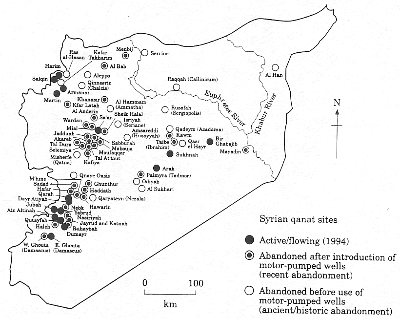
Bibliography :
- Remy Boucharlat, The falaj or qanât, a polycentric and multi-period invention, ArcheOrient – Le Blog, September 2015 ;
- Pierre Lombard, Du rythme naturel au rythme humain : vie et mort d’une technique traditionnelle, le qanat, Persée, 1991 ;
- Aly Mazaheri, La civilisation des eaux cachées, un traité de l’exploitation des eaux souterraines composé en 1017 par l’hydrologue perse Mohammed Al-Karaji, Persée, 1973 ;
- Hassan Ahmadi, Arash Malekian, Aliakbar Nazari Samani, The Qanat: A Living History in Iran, January 2010;
- Evelyne Ferron, Egyptians, Persians and Romans: the interests and stakes of the development of Egyptian oasis environments.
NOTE:
[1] The ten cities forming the Decapolis were: 1) Damascus in Syria, much further north, sometimes considered an honorary member of the Decapolis; 2) Philadelphia (Amman in Jordan); 3) Rhaphana (Capitolias, Bayt Ras in Jordan); 4) Scythopolis (Baysan or Beit-Shean in Israel), which is said to be its capital; It is the only city west of the Jordan River; 5) Gadara (Umm Qeis in Jordan); 6) Hippos (Hippus or Sussita, in Israel); 7) Dion (Tell al-Ashari in Syria); 8) Pella (Tabaqat Fahil in Jordan); 9) Gerasa (Jerash in Jordan) and 10) Canatha (Qanawat in Syria)