Étiquette : cotton
The challenging modernity of the Indus Valley Civilization

Get an easy-to-print pdf file of this article
Karel Vereycken, Paris, France, January 2023
A major archaeological discovery has just been made in Israel in 2022: the first evidence of the use of cotton fibers in the Near East and among the oldest in the world, dating back nearly 7,000 years, was discovered by Israeli, American and German archaeologists during an archaeological excavation at Tel Tsaf, southeast of Beit She'an, in the Jordan Valley of Israel.

So far, the earliest available evidence of cotton fibers in the area was dated to a few hundred years later, to the late Chalcolithic (Copper Age) and Early Bronze Age (about 5,000 to 6,500 BCE) from the archaeological site of Dhuweila in eastern Jordan.
Discovered in 1940, the site of Tel Tsaf reveals its secrets. « Tsaf is characterized by an amazing preservation of organic materials, » said Professor Danny Rosenberg of the Zinman Institute of Archaeology at the University of Haifa. « Tel Tsaf was a kind of pole that concentrated important commercial activities and had established contacts with many other peoples, » Rosenberg believes. « There was massive storage capacity there to accommodate grain, enormous capacity if you compare it to other sites.
For example, the earliest evidence of the social use of beer drinking and ritual food storage has been found there. Rosenberg and the other researchers also found beads from contemporary Anatolia, Romania, Egypt and other parts of Africa; pottery from Iraq, Syria and Armenia; and the earliest copper and other metals found in the world.
“Wool Tree” and “Cotton Roads”
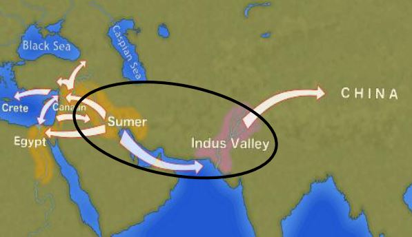
The cotton found in Israel, probably came from the Indus region—modern Pakistan/India—which was the only place in the world that had begun to domesticate cotton at that time before its cultivation appeared in Africa thousands of years later.
« What’s interesting about this early evidence of a link to such a distant region is that it comes from fibers – microscopic pieces of ancient yarn. We assume that these cotton fibers, found along with wool fibers and plant fibers, arrived at the site as part of fabrics or clothing, i.e., ancient textiles, » Rosenberg says.
In addition, cotton was not only used for clothing: « In the prehistoric era, textiles were involved in many areas of life, not only in clothing but also in hunting, fishing … This is much more important than just saying that what we found are pieces of clothing that were worn by the inhabitants of the area. This discovery tells us a lot about the economic practices of the area, » says Rosenberg.
Since cotton had never been grown in Tel Tsaf, it was a surprise for the researchers to find it, and they felt that its presence underscored the city’s importance as a global trading hub at the heart of what could be called, the « Cotton Roads » of those days.
Growing cotton poses major challenges: a moderate to tropical climate and vast amounts of water. Just to produce a single T-shirt and a pair of jeans (representing about 1 kg of cotton), no less than 20,000 liters of water are required! Which civilization can afford such a performance at the beginning of the 7th millennium BC?
The Indus Valley civilization (IVC)
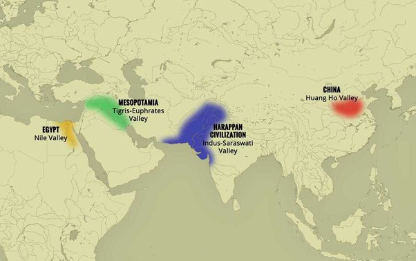
The term « Indus Valley Civilization » (IVC) refers to a vast cultural and political entity that flourished in the northern region of the Indian subcontinent between about 8000 and about 1900 BCE., a region that stretched from Baluchistan (Pakistan) in the west to Uttar Pradesh (India) in the east and from northeastern Afghanistan in the north to Gujarat (India) in the south.
In the absence of both literary sources and remnants of palaces and temples to confirm it, one cannot qualify this entity as a “Kingdom” or an “Empire”. Its modern name (IVC) derives simply from its location in the Indus Valley, but also goes under the name of the « Indus-Sarasvati civilization » or « Harappan civilization ». These last designations come from the river Sarasvati, mentioned in the Vedic sources, which flowed next to the Indus and which would have disappeared, and from the ancient city of Harappa (Punjab, Pakistan), discovered by the British in 1829, but deliberately left unexplored.
The rise of a great urban civilization in the Indus Valley, which reached its maturity around 2500-2400 BCE, was long considered a sudden and mysterious phenomenon. Today, a series of discoveries allows us to follow, from 7000 to 2500 BCE, a series of transformations and innovations whose cumulative effects, stimulated by the enlargement of the network of exchanges from 3000 BCE onwards, created the conditions for the development of an incredibly modern and prosperous urban civilization.
Enter Mehrgarh, the light of the world!
Since prehistoric times, the Indus region has been pioneering and rich in discoveries. As an example, for the Guinness Book of Records, although a case apart, the farming village of Mehrgarh (Baluchistan, Pakistan) which dates from the Neolithic (using only stones as tools) but can be considered as the key culture and city that lead humanity, as early as in the 8th millennia BCE, from the Stone Age into the Age of Copper.
The site is located on the principal route between what is now Afghanistan and the Indus Valley: this route was also undoubtedly part of a trading connection established quite early between the Near East and the Indian subcontinent.
Excavations in Mes Aynak (Afghanistan), where archaeologists are only beginning to find remnants of a 5,000-year-old Bronze Age site beneath the Buddhist level, including an ancient copper smelter, will undoubtedly shed new light on these relationships.
On the basis of a variety of well-documented archaeological finds, it has been established that “pre-Harrapan” Mehrgarh, made several historical breakthroughs for the benefit of humanity as a whole.
Mehrgarh gave the world:
- among the oldest traces of agriculture (wheat and barley) and breeding (cattle, sheep and goats) in South Asia ;
- the first breweries (with wheat and barley);
- the oldest reservoirs for irrigated agriculture and flood prevention;
- the oldest traces of cotton culture (6th millennium BCE);
- the oldest jewel, called the « Mehrgarh amulet » (6th millennium BCE), produced with the « lost wax » bronze casting technique ;
- the oldest bow drills (in green jasper) allowing to drill holes in lapis lazuli and carnelian;
- the very first traces of successfull dentistry practices (!) (9th millennium BCE); The inhabitants of Mehrgarh appeared to have developed an understanding of surgery and dentistry, as evidenced by the drilled teeth of some of the skeletons found at the site. Analysis of the teeth shows that prehistoric dentists worked to treat toothaches with drills made from flint heads. The work was so elaborate that even modern dentists are surprised at the efficiency with which the Mehrgarh « dentists » removed decaying tooth tissue. Among the remains, a total of eleven drilled crowns were found, with one example showing evidence of a complex procedure involving the removal of tooth enamel followed by carving of the cavity wall. Four of the teeth show evidence of decay associated with the drilled hole. None of the individuals with drilled teeth appear to have come from a special tomb or shrine, indicating that the oral health care they received was available to all.

Densely populated
Originally, the IVC was built around the fishy meanders of the Indus, a river nearly 3200 kilometers long that flows from the Himalayan mountains towards the Arabian Sea. Like the populations of other great river valleys, this society was seduced by the fertility of the land as well as by the possibility of using the Indus as a transportation route.
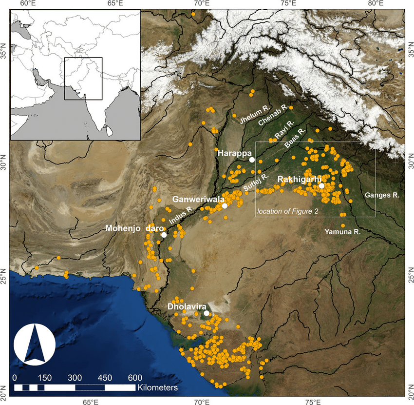
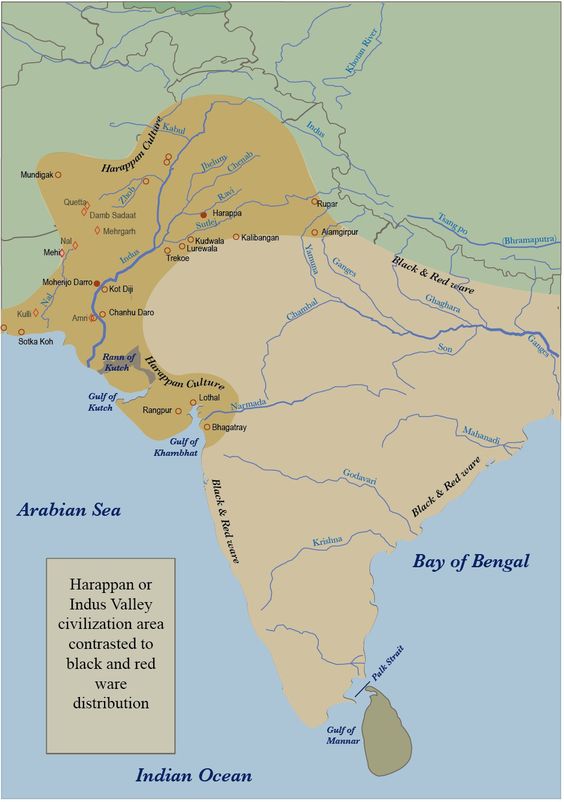
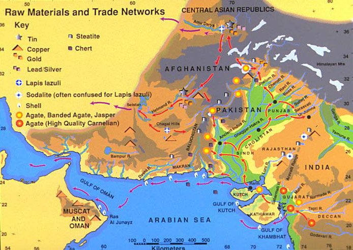
The IVC, whose prosperity rests largely on the increasingly systematic exploitation of the rich silt of the Indus, spread over an immense territory encompassing the entire Indus Valley and part of Indian Gujarat. It is necessary to add to the vast zone of distribution of the Indus civilization some Harappan « colonies » or outposts like Sutkagan Dor (Ballochistan, Pakistan), close to Gwadar on the edges of the sea of Oman, at the Iranian-Pakistani border, and the lapus lazuli mining town of Shortugai, close to Amu Darya river, at the Afghan-Tajik border, at nearly 1,200 kilometers of Mohenjo-daro, by far the largest IVC urban concentration.
At its peak, this civilization was twice as large as the Old Kingdom of Egypt. With an area of 2.5 million square kilometers, it was at the time the largest civilization in the world: it included 5 million people, or 10 % of the world population at the time, much more than less older civilizations as Sumer (0.8 to 1.5 million people) or ancient Egypt (2 to 3 million).
To date, about 2,000 sites have been discovered in India, Pakistan and Afghanistan. Because of various wars and conflicts, only 10 % of the territory of these sites has been excavated and scientifically investigated. On the Indian subcontinent, the main centers of this civilization are Harappa (estimated 23,500 inhabitants) and Mohenjo-daro (est. 40,000 inhabitants) in Pakistan and Lothal, Dholavira and Kalibangan in India. In addition to trade relations with Mesopotamia and Iran, the Harappan city-states also maintained active trade relations with the peoples of Central Asia.
Agriculture, crafts and industry
Agriculture, animal husbandry, industry, trade and commerce were the main source of income.
Agriculture was the main occupation of the people of the Indus Valley. They cultivated barley and wheat on a large scale (and made beer) but also other crops such as legumes, cotton, cereals, sesame, dates, mustard, melons, peas, etc.
There is no real evidence of rice, but a few grains of rice have been found in Rangpur and Lothal.
In the towns of Mehrgarh, Harappa, and Mohenjo-daro, there are remains of large granaries, suggesting that they produced more than they needed and physically stocked cereals and other food products in case of crop failure.
Animal husbandry was another major occupation. Seals suggest that they domesticated cows, buffalos, goats, sheep, pigs, etc. Camels and bullocks were also domesticated and used as beasts of burden. Camel bones have been found in large numbers at many sites, but there is no trace of them on the seals. During the excavation of Surkotado in Gujarat, India, the jawbone of a horse was found. Terracotta figurines representing a horse were found in Nausharo and Lothal.
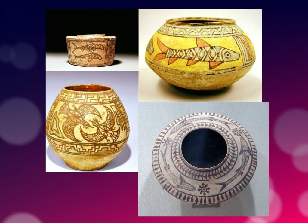
The inhabitants of the Indus Valley were very skillful. They made ceramics, metal vessels, tools and weapons, weaved and spun, dyed and practiced other crafts with potter’s wheels. The weavers wore clothes made of cotton and wool. They knew leather, but there is no record of silk production.
The inhabitants of this civilization originally came from the Bronze Age and used stone tools, but they soon excelled in the manufacture and processing of gold, silver, copper, lead and bronze, especially for artistic ornaments of great finesse.
Artisans made jewelry in Mohenjo-daro, Chanho-daro and Lothal. They used ivory and various precious stones such as carnelian, lapis lazulite, agate and jasper to make them. Shell work was also a thriving industry. Craftsmen in the coastal colonies used shells to make buttons for shirts, pendants, rings, bracelets, beads, etc.
To supply the production of these craft professions, they needed to import various raw materials. To produce bricks and ceramics, clay was available locally, but for metal they had to acquire it from abroad. Trade focused on importing raw materials to be used in Harappan city workshops, including minerals from Iran and Afghanistan, lead and copper from other parts of India, jade from China, and cedar wood floated down rivers from the Himalayas and Kashmir. Other trade goods included terracotta pots, gold, silver, metals, beads, flints for making tools, seashells, pearls, and colored gemstones, such as lapis lazuli and turquoise.
Ox carts were used to transport goods from one place to another. They also constructed barges used on the waterways along the Indus and its tributaries for transportation.
One of the ways historians know about the maritime trade network operating between the Harappan and Mesopotamian civilizations is the discovery of Harappan seals and jewelry at archaeological sites in regions of Mesopotamia, which includes most of modern-day Iraq, Kuwait, and parts of Syria. Long-distance sea trade over bodies of water—such as the Arabian Sea, Red Sea and the Persian Gulf—may have become feasible with the development of plank watercraft that were each equipped with a single central mast supporting a sail of woven rushes or cloth.
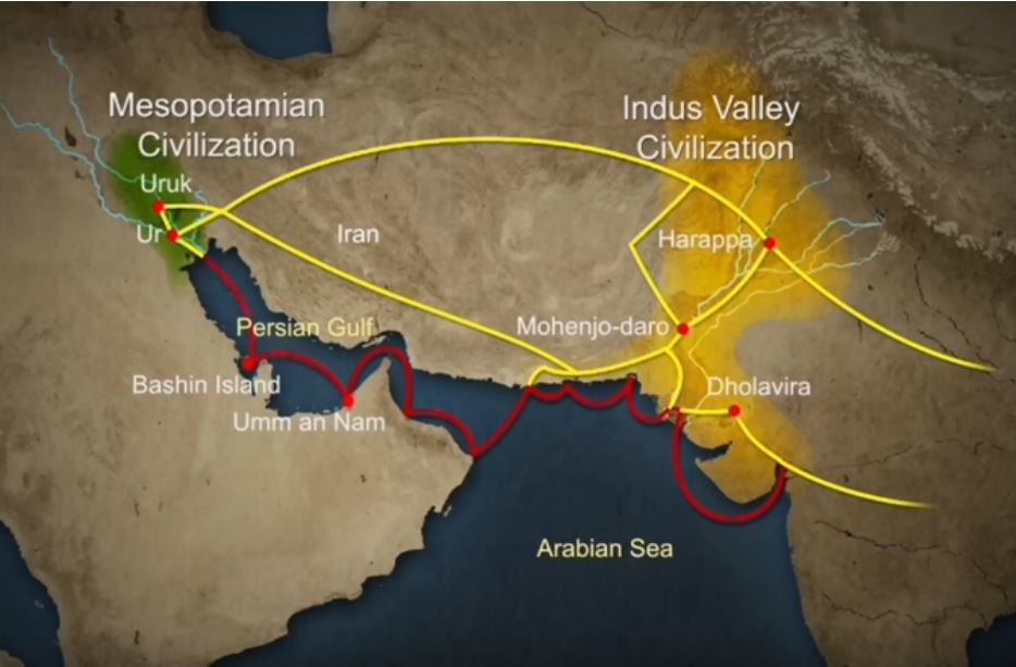
Historians have also made inferences about networks of exchange based on similarities between artifacts across civilizations.
Between 4300 and 3200 BCE, ceramics from the Indus Valley Civilization area show similarities with southern Turkmenistan and northern Iran. During the Early Harappan period—about 3200 to 2600 BCE—there are cultural similarities in pottery, seals, figurines, and ornaments that document caravan trade with Central Asia and the Iranian plateau.
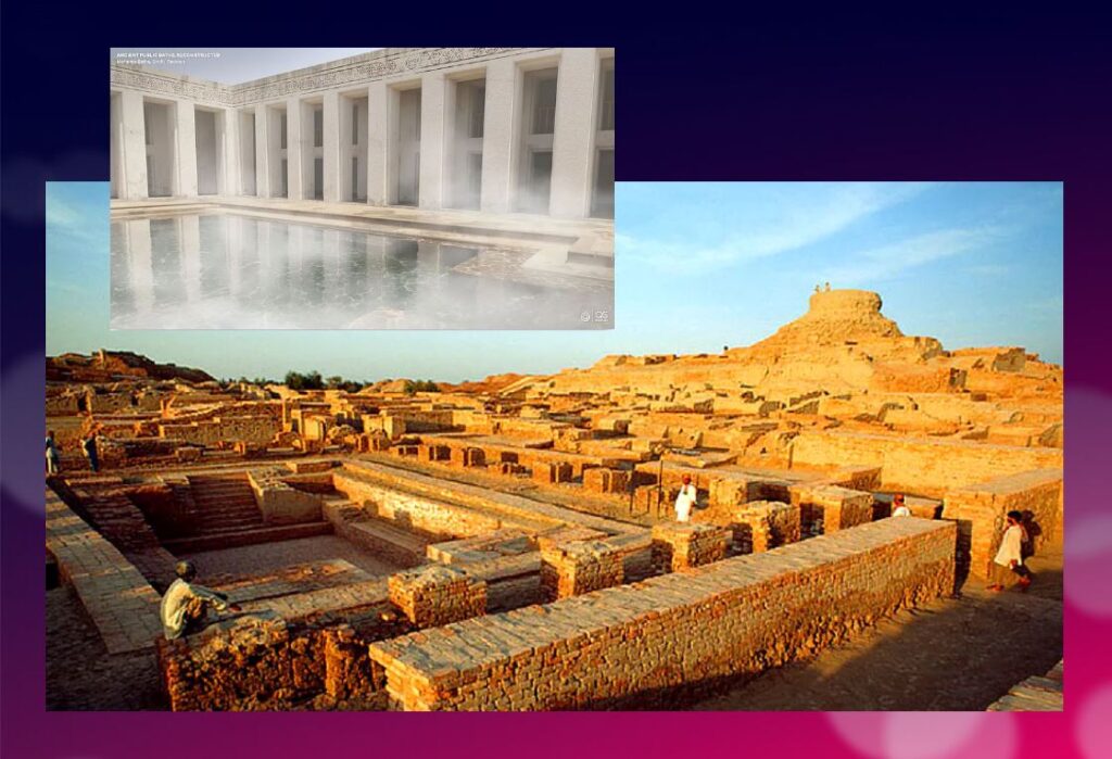
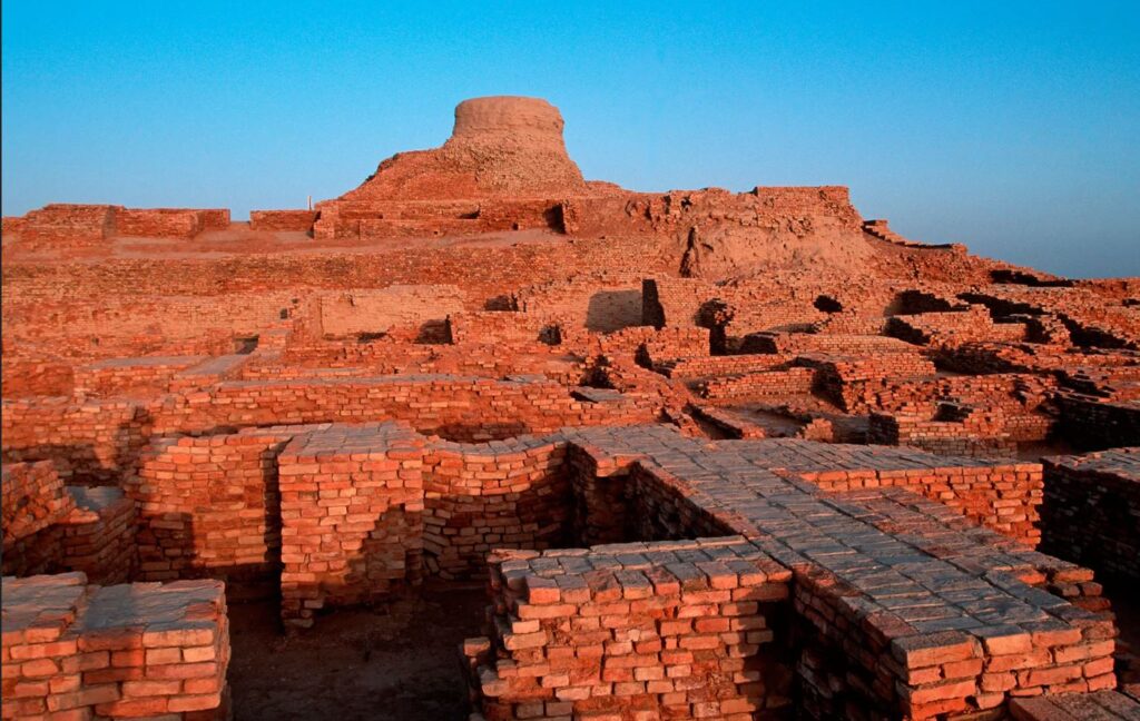
The wonders of Mohenjo-daro
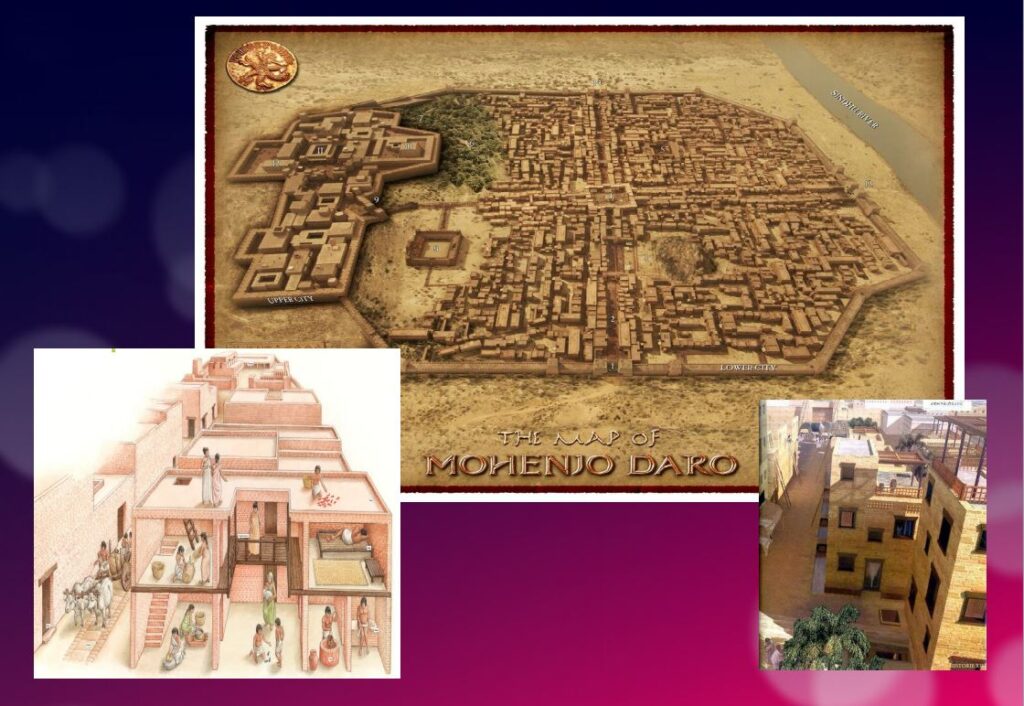
Sometimes referred to as the « Manhattan of the Bronze Age » for the grid pattern of the city plan, Mohenjo-daro (Sind, Pakistan) remained buried under meters of alluvial sediment until 1922.
A real metropolis made of baked bricks, it covers more than 200 hectares. Strictly squared, cut in two by a street of ten meters wide, divided from north to south by a dozen arteries drawn with the cord, and crossed from east to west by paved streets, Mohenjo-daro represents, by its strictly reflected urban framework, the model city of the Indus civilization. It could have accommodated up to 40,000 people!
The Harappans were masters of hydraulic engineering, a “riparian” people working in river corridors practicing irrigated agriculture. They mastered both the shaduf (an irrigation tool used to draw water from a well), and windmills.
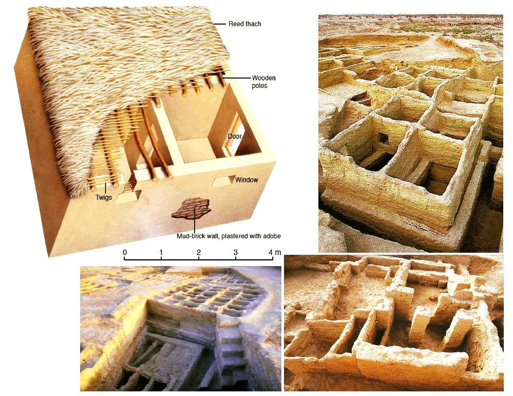
In the Harappan cities, the domestic and manufacturing areas were separated from each other.
The inhabitants, living in one-, two-, and sometimes three-story dwellings, seem to have been mainly artisans, farmers, and merchants. The people had developed the wheel, cattle-drawn carts, flat-bottomed boats large enough to carry goods, and perhaps also sailing. In the field of agriculture, they had understood and used irrigation techniques and canals, various agricultural implements, and had established different areas for livestock grazing and cultivation.
Seals and harrapan script
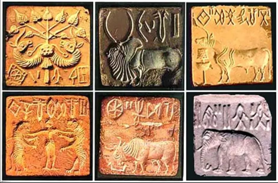
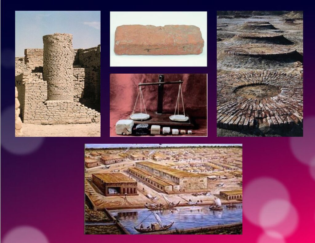
Among the thousands of artifacts found at the various sites are small soapstone seals just over one inch (3 cm) in diameter, used to sign contracts, authorize land sales, and authenticate the point of origin, shipment, and receipt of goods in long-distance trade. On each seal is a small text in Harappan, a language yet to be deciphered.
Among the thousands of artifacts found at the various sites are small soapstone seals just over one inch (3 cm) in diameter, used to sign contracts, authorize land sales, and authenticate the point of origin, shipment, and receipt of goods in long-distance trade.
Commercial contacts between the Indus and Sumer populations are well documented. Numerous seals from the Indus Valley have been discovered in Mesopotamia. On each seal, a small text in Harappean, a language that remains to be deciphered.
If 4,200 texts reached us, 60 % of them are seals or mini-tablets of stone or copper, engraved, and they comprise on average… only five signs! The longest text has 26 signs. The texts are always accompanied by the image of an animal, often a unicorn or a majestic buffalo. They were intended to mark goods, probably indicating the name of the owner or the recipient and a quantity or a year. Trying to decipher the Indus language is a bit like trying to learn French only from the labels on the food shelf of a supermarket!
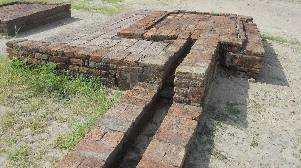
The invention of sanitation
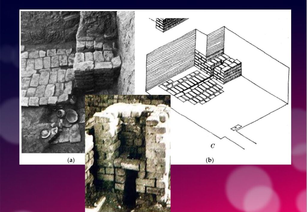
In addition to this particular attention that they paid to urban planning, the members of the Indus civilization also seem to have been pioneers of modern hygiene. Some cities, notably Mohenjo-daro, were equipped with small containers (dustbins) in which the inhabitants could deposit their household waste.
Anticipating our « all to the sewer » systems imagined in the 16th century by Leonardo da Vinci for the project envisaged by François I for the new French capital Romarantin, many cities had already public water supply and an ingenious sanitation system.
In many cities, including Mohenjo-daro, Harappa, Lothal and Rakhigari, individual houses or groups of houses were supplied with water from wells. This quality fresh water was used as much for food and personal hygiene (baths, toilets) as for the economic activities of the inhabitants.
As an example, the sanitation system of the port city of Lothal (Gujarat, India) where many houses had a bathroom and private brick latrines. The wastewater was evacuated through a communal sewer system that led either to a canal in the port, or to a soaking pit outside the city walls, or to buried urns equipped with a hole allowing the evacuation of liquids, which were regularly emptied and cleaned.
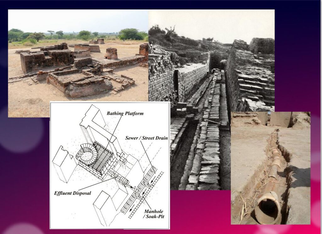
Excavations at the Mohenjo-daro site have also revealed the existence of no less than 700 brick water wells, houses equipped with bathrooms and individual and collective latrines. Toilets were an essential element. However, early archaeologists erroneously identified most toilets as post-cremation burial urns or simple cesspools. Many buildings in the city were two or more stories high. Water from the roof and bathrooms of the upper floors was channeled through closed clay pipes or open troughs that emptied, if necessary via the toilets, into the covered sewers underneath the paved street.
This extraordinary achievement is confirmed by a 2016 scientific study, entitled « The Evolution of Toilets Around the World Across the Millennia, » which reports that,
The earliest multi-flush toilets connected to a sophisticated sewage system that have been identified so far were found in the ancient cities of Harappa and Mohenjo-Daro in the Indus Valley, dating from the middle of the third millennium BC. Nearly every dwelling unit in Harappa, Mohenjo-Daro, and Lothal was equipped with a private bath-toilet area with drains to carry dirty water into a larger drain that emptied into the sewer and drainage system.
Till now, it are the Minoan (Crete) civilization and China that have been credited for the first use of underground clay pipes for sanitation and water supply. In the Cretan capital Knossos, there was a well-organized water system to bring in clean water, to evacuate wastewater and to provide storm sewers for overflow in case of heavy rains.
In Knossos existed also one of the earliest uses of flush toilets, dating back to the 18th century BCE. The Minoan civilization had stone sewers that were periodically cleaned with clean water. Crete, of course, was a large provider of Copper ore for the entire world in Antiquity and had vast international trade connections.
Religious and cultural worldview
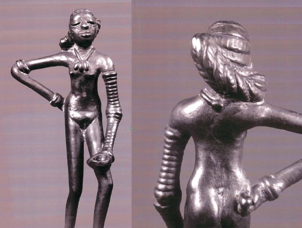
In the IVC, fertility rituals were probably observed in order to promote a full harvest as well as for women’s pregnancies, as evidenced by a number of figurines, amulets and statuettes with female form.
It is thought that the people, like the Dravidians who some believe were the origin of the Indus Civilization, worshiped a “mother goddess” and possibly a male companion represented as a horned figure in the company of wild animals.
The « Great Bath » at Mohenjo-daro would have been used for purification rites related to religious belief, but it could just as easily have been a public pool for recreation. Our knowledge of the religious beliefs of this culture remains in the realm of mere hypothesis.
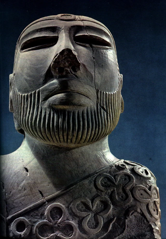
The title of the famous statue of the « Priest-King » found at Mohenjo-daro is misleading, as there is no evidence that it is a king or a priest, and it may be a simple cotton trader…
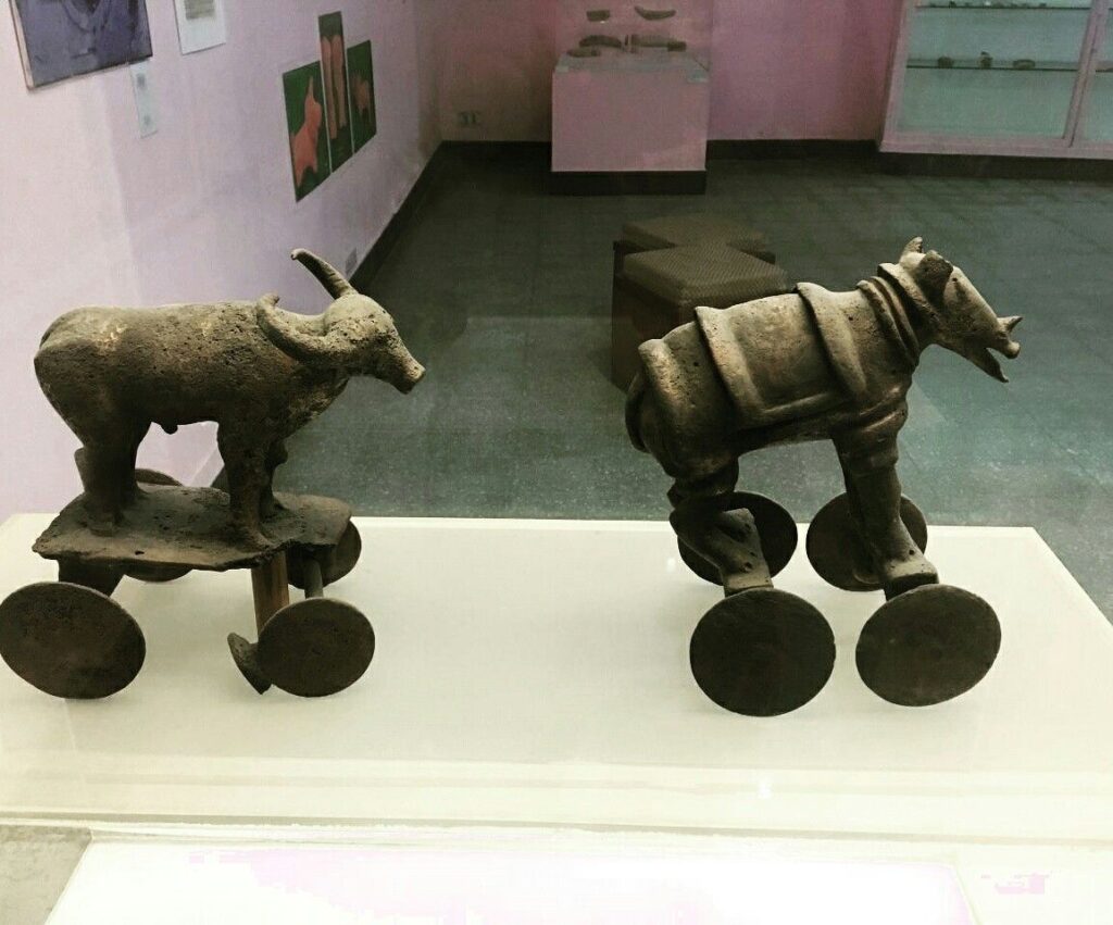
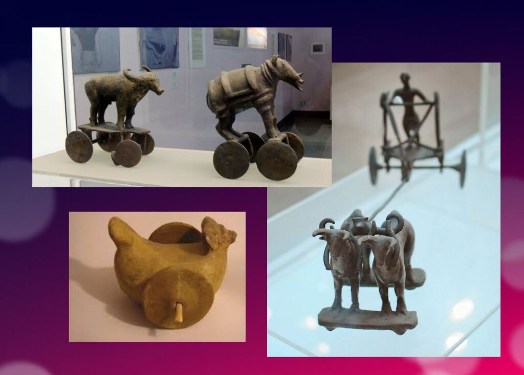
Apart from pottery, certain types of elementary weapons (spearheads, axes, arrows, etc.) and certain tools for practical purposes, two types of artifacts give us cultural clues about Harappean society.
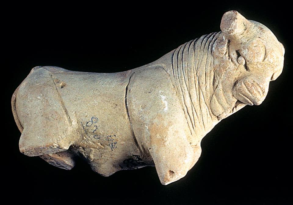
First, some figurines, which we try to interpret as devotional objects, seem to be simple toys. For others, they are clearly toys, notably animals (oxen, buffaloes, elephants, goats and even a simple hen), made of bronze or terracotta, mounted on small carts with wheels.
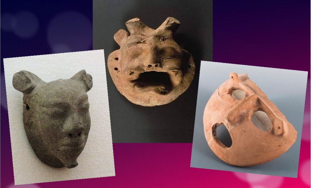
Second, among other objects expressing a high level of sensitivity and consciousness, a series of masks, some of which seem inspired by Mongolian masks.
These masks are clearly intended to serve comic or tragic representations and remind us of the ancient masks that have come down to us from classical Greece.
Older than Sumer and Egypt?
Archaeological excavations of the IVC got off to a late start, and it is now believed that some of the achievements and « firsts » attributed to Egypt ( – 3150 BC) and Mesopotamia ( – 4500 BC) may in fact belong to the inhabitants of the Indus Valley civilization.
In May 2016, the report published by a team of researchers from IIT Kharagpur, Institute of Archaeology, Deccan College Pune, Physical Research Laboratory and Archaeological survey of India (ASI), published by the journal Nature, shattered a number of “facts” that were considered unshakeable certainties.
Until now, the 900 years of the « mature » phase of the IVC was dated as ranging from 2800 to 1900 BCE. However, the aforementioned Indian study indicates that this civilization was much older than previously thought – it is at least 8,000 years old!
To determine the age of this civilization, researchers dated pottery using a technique called optically stimulated luminescence (OSL) – and found it to be nearly 6,000 years old, the oldest pottery known to date.
Other artifacts have been dated to 8,000 years ago. The results come from a major site excavated at Bhirrana (Haryana, India) that shows the preservation of all cultural levels of this ancient civilization, from the pre-Harappan phase through the Early Harappan to the Mature Harappan period. Bhirrana was part of a high concentration of sites along the mythical Vedic river « Saraswati », now dried up, an extension of the Harki-Ghaggar River in the Thar Desert.
The submerged cities of the Gulf of Khambhat
These new dates converge with the discovery, in January 2002, of ruins of submerged cities in the Gulf of Khambhat (formerly Cambay), off the coast of the state of Gujarat in northwest India.
It is the oceanographers of the National Institute of Ocean Technology (NIOT) of Madras who made this discovery. The team was surveying the muddy sea 30 km off the coast of the state of Gujarat, in the Gulf of Khambhat, to measure the levels of marine pollution. As a routine measure, they recorded acoustic images of the ocean floor.

It was only several months later, while analyzing the data, that the team realized that they had, without knowing it, obtained images of the ruins of a huge city, sunken 40 meters below sea level. And, at the end of January 2002, after having spent weeks to dredge the site and to bring up more than 2 000 objects, the team of the NIOT was able to make extraordinary revelations.
The ruins stretch for 9 km along the banks of an ancient river, and the remains of a dam can be distinguished. The sunken city shares striking similarities with the sites of the Indus civilization. One of the buildings, the size of an Olympic swimming pool, with collapsed steps, recalls the Great Bath of Mohenjo-daro. Another rectangular monument, 200 m long and 45 m wide, is as large as the acropolis discovered at Harappa. The team of NIOT also glimpsed another building, a kind of granary, made of mud bricks, 183 m long. Near these monumental installations, rows of rectangular buildings that resemble the foundations of ruined houses can be seen, and even a drainage system and roads. On another visit to the site, the team recovered polished stone tools, ornaments and figurines, pottery debris, semi-precious stones, ivory and the fossilized remains of a human spine, jaw and tooth. But the team was not at the end of its surprises.
It sent samples of a fossilized log to two major Indian laboratories specializing in dating methods: the Birbal Sbahni Institute of Paleobotany (BSIP) in Lucknow and the National Geophysical Research Institute (NGRI) in Hyderabad. The BSIP dated it to 5500 BCE, while the NGRI dated the sample much earlier, probably to 7500 BCE.
This dating would make Khambhat the oldest site discovered in India. According to some, this discovery could mark the end of the theory according to which urbanization spreads from Asia from the west towards the Indus. This dating caused intense controversy. Archaeologist G. Possehl points out that there is no reason to believe that the fossilized piece of wood belongs to the ruins of the ancient city, given the strong sea currents in the region, it could have come from elsewhere. NIOT’s team acknowledged the validity of these criticisms and assured that other objects would be subjected to dating methods. It is also a question of understanding how this city was sunk and how it ended up 30 km from the coast.
Harsh Gupta, geologist, thinks that it is a gigantic earthquake which caused the destruction of the city. We are in a high seismic risk area, and the 2001 Bhuj earthquake showed the vulnerability of the region to such phenomena. However, the priority is to definitively establish the age of the sunken city and prove it to be the most exciting discovery of this century.
Historical cradle of textiles

In his book Empire of Cotton, A Global History (2015) Sven Beckert traces in depth the development of what the ancients, intrigued by its resemblance to the feel of wool, called the « wool tree. » While this plant grows in both temperate and tropical climates, it needs an abundance of moisture to thrive fully, which consigns its cultivation to naturally and then artificially irrigated river valleys.
According to the author, « The farmers of the Indus Valley were the first to spin and weave cotton. In 1929, archaeologists found fragments of cotton textiles at Mohenjo-Daro, in present-day Pakistan, dating from 3250 to 2750 BCE. Cotton seeds found in nearby Mehrgarh have been dated to 5000 BCE. Literary references also attest to the antiquity of the cotton industry in the subcontinent. The Vedic scriptures, composed between 1500 and 1200 BCE., allude to the spinning and weaving of cotton…”
Historically, the discovery of the first cotton fragments was made at Mohenjo-daro during an expedition led by Sir John Marshall, Director General of the Archaeological Survey of India from 1902 to 1928. In his book on Mohenjo-daro and the Indus Civilization, Sir Marshall relates that fragments of cloth were wrapped around a silver perfume pot and a salt shaker.
Early forms of Self-government?
The fact remains that the political organization of the Indus cities escapes the experts. Because contrary to the Mesopotamian and Egyptian civilizations, the researches realized on the sites of the valley of the Indus did not bring to light any temple or palace of scale. There is no proof either of the existence of a permanent army…
Of what to wonder about the presence or not of a political power. Panic among British archaeologists and geopoliticians always inclined to project their own colonial ideology of aristocratic castes on the rest of the world.
In reality, each city seems to have had its own governor, or citizen council coordinating with other urban areas, all adhering to a number of common principles considered mutually beneficial.
This “Coincidence of Opposites”, of great diversity with perfect similarity, intrigues expert John Keay:
What amazed all those pioneers, and what remains the distinguishing characteristic of the several hundred Harappan sites now known, is their apparent similarity: ‘Our overriding impression is of cultural uniformity, both throughout the several centuries during which Harappan civilization flourished, and over the vast area it occupied.’ The ubiquitous bricks, for example, all have standardized dimensions, just as the stone cubes used by the Harappans to measure weight are also standardized and based on the modular system. The width of roads conforms to a similar module; thus, streets are generally twice as wide as side streets, while main arteries are two or one and a half times as wide as streets. Most of the streets excavated so far are straight and run north to south or east to west. The city plans thus conform to a regular grid pattern and seem to have retained this arrangement through several phases of construction.
Hence, given the existence of a unified system of weights and measures; given the similarity of urban organization as well as the standardization of the size of terracotta bricks for hundreds of cities, it is therefore simply impossible that the every man for himself reigned supreme.
Cradle of democracy?
In 1993, in an article entitled « The Indus Valley Civilization, Cradle of Democracy? », published by the UNESCO Courier, the internationally renowned Pakistani archaeologist and museologist, Syed A. Naqv, who has been fighting for the preservation of the Mohenjo-daro site, attempted to answer the question.
In all the highly developed civilizations of the past – Mesopotamia, the Nile Valley, Anatolia, China – the pervasive influence of an imperial authority can be felt, providing patronage for the arts and directing the evolution of society. A close examination of such an imperial authority over this civilization, which flourished some 5,000 years ago and covered almost twice the area of the civilizations of Mesopotamia and the Nile combined seems to belie the presence of an authoritarian regime, the Indus civilization had a well-disciplined way of life, civic controls and organizational system which could only have stemmed from the kind of “rule by the people” that was exercised in some Greek city-State some 2,000 years later. Did Greece give birth to democracy, or did Greece simply follow a practice developed earlier?
Although there are no large structures acting as centers of authority,
the discoveries made so far suggest that the rule of law extended over an area measuring roughly 1,600 kilometers from the north to the south and more that 800 kilometers from east to west. The main argument in support of this thesis is the existence of well-established norms and standards which would have required the consensus of the people if they had not been imposed by an authoritarian regime. It is impossible to ignore the evidence furnished by the perfect planning of the great city of Mohenjo-daro and the use in its construction of standard-sized bricks 27.94 cm long, 13.96 cm wide and 5.71 cm thick.
In the two large cities of Mohenjo-daro and Harappa, about 600 km distant,
the grid pattern of the street layout uncovered by the archaeological excavations shows that great attention was paid to the security of the inhabitants and suggests the existence of a highly developed and well-monolithic system of civic control.
The same is true of the highly sophisticated sewage system and the existence of
a virtually complete series of highly polished stone weights. Their shapes are cubical, half-cubical, cylindrical and spherical, and very few of them are reported to be defective. They provide yet another proof of a civic authority maintaining consistent commercial standards.
It is not possible to conclude that such « a philosophical conception of democracy exists until the Harappan script is deciphered and written evidence is provided. But the signs are there, and further research in this direction may well establish that ‘government by the people’ originated in the Indus Valley, » the author concludes.
Finally, since this agricultural people, who knew the use of the spears and the arrows but didn’t leave any trace of a major military activity – few weapons nor fortifications with exclusively defensive purpose have been found – , many observers agree to say that this society could have known the longest period of peace of the history of the humanity.
Decay and fall
In two of his books, the Timaeus and the Critias, the Greek philosopher Plato tells the story « certainly true, although strange » of a maritime people with incomparable power: the Atlantes whose civilization and capital he describes in great detail.
Starting 10,000 years before our era from an island located beyond the columns of Hercules, the Atlanteans would have ended up dominating the whole of Africa and Western Europe.
In a passage which is not without recalling the type of political organization which could exist in Mohenjo-daro, Critias specifies that Atlantis was then inhabited « by the various classes of men who deal with the trades and agriculture. The warriors, separated from the beginning by divine men, lived separately, possessing all that was necessary for their existence and that of their children. Among them, there were no particular fortunes; all goods were in common: they demanded from the other citizens nothing beyond what they needed to live, and fulfilled in return all the obligations that our talk of yesterday attributed to the defenders of the fatherland as we conceive them. »
Perhaps speaking metaphorically, Plato states that initially virtuous, the Atlantis civilization would have sunk into excess, arrogance and corruption to the point of being chastised by Poseidon himself for having embarked on one war too many, this time against Athens. And « in the time lapse of a single terrible day and night (…) the island of Atlantis sank into the sea and disappeared ».
At the historical level, the sudden decline of the Indus civilization around 1900 BC remains a mystery. Historians point to aspects of Minoan civilization (Crete) showing astonishing similarities with the IVC, especially watermanagement and early sewer systems in Knossos, lost wax broze casting techniques and bull fighting.
A few traces of fire and destruction, as well as forty skeletons wounded with knives and found without burial at Morenjo-daro, first suggested an invasion by Aryan peoples from Central Asia or the Iranian plateau. « This theory has now been abandoned. We have indeed found no effective trace of massacres or violence on the sites of the Indus Valley, or furniture that could be associated with such populations, » says Aurore Didier, researcher at the CNRS and director of the Indus mission.
Another hypothesis, an inability to strengthen its resilience to climatic chaos. « The samples taken in the northwest of India have shown that the climate there has changed significantly about 2000 years before our era. It is reported that this was also the case in Mesopotamia. « It became more like the dry and arid climate of today, which disrupted the cultivation and, in fact, the trade of the Indus civilizations. The ensuing socio-economic upheaval may have led to the decline of these societies. This hypothesis is the most commonly accepted to date, » says the archaeologist.
The inhabitants would have left their valleys become infertile to migrate to the plains of the Ganges. « This was accompanied by a change in livelihood strategies. The Indus civilization gradually converted to summer cereal crops based on rice and millet, two commodities more able to withstand these new climatic conditions and requiring, for rice, the development of irrigated agriculture, » says Aurore Didier. « It has also forged links with new trading partners.”
So there is no reason to talk about the « collapse » of a society in the sense of collapsologists. It is rather a gradual adaptation to the evolution of the environment, spread over several centuries.
As the excavations of the sites of the Indus Valley civilization continue, new information will undoubtedly contribute to a better understanding of its history and development. Any additional knowledge of this common civilizational legacy will serve in the future as a basis for fraternal cooperation between Pakistan, India and Afghanistan and others.
In the meantime, instead of trying to copy the barbaric « models » of the Mongolian Empire, the Roman Empire or the British Empire, the « elites » of the transatlantic world would do better to draw inspiration from a magnificent civilization that seems to have prospered for 5,000 years without perpetual wars and massacres, but simply thanks to a good mutual understanding, at the national level, between citizens, and thanks to mutually beneficial cooperation with the overriding majority of its distant partners.
The Indus Valley Civilization’s modernity, capable of offering food, shelter, water and sanitation to all, in a mirror image, shows all of us living in the present, how backwards we became.
The splendors of the kingdoms of Ife and Benin

The breathtaking beauty of the XIIth century bronze heads of Ife (Nigeria) challenge the colonial view that Africa was a virgin continent, populated by animals and a few primitive tribes which failed walking their first steps into « history ».
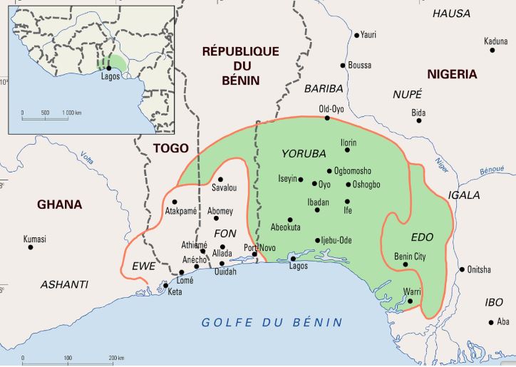
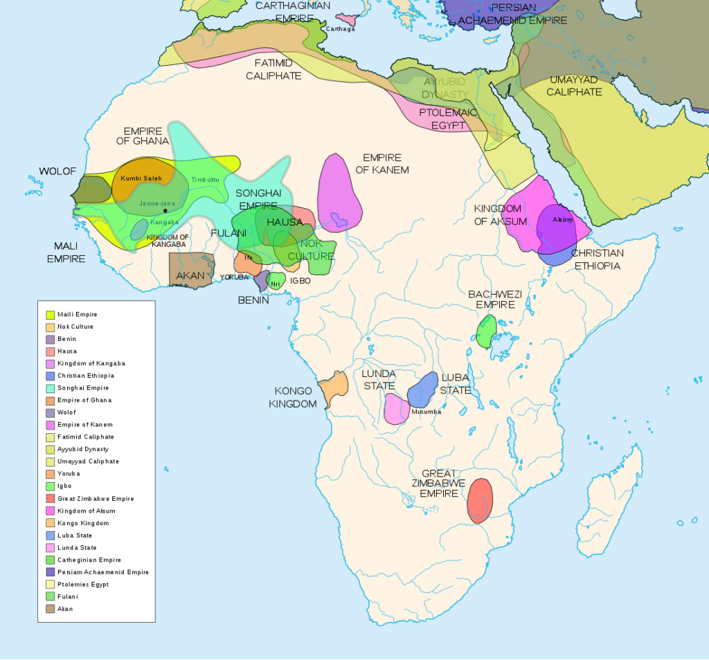
Today inhabited by a half million people, the city of Ife in southwest Nigeria, was formerly the religious center and former capital of the Yoruba people whose prosperity was essentially the fruit of their trade with the peoples of West Africa along the 4200 km long Niger River and beyond.
What some call today “Yorubu-land”, inhabited by some 55 million people, covered some 142,000 km2 comprising vast parts of countries such as today’s Nigeria (76%), Benin (18.9%) and Togo (6.5%).
Today, the Yoruba people live in Ghana, Burkina Faso, Ivory Coast and, since the slave trade, in the United States. It is not surprising, therefore, that yoruba, also the name of one of the three major languages of Nigeria, is also spoken in parts of Benin and Togo, as well as in the West Indies and Latin America, including Cuba and other settlements populated by descendants of African slaves.
An extraordinary discovery
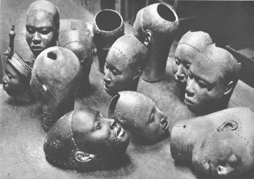
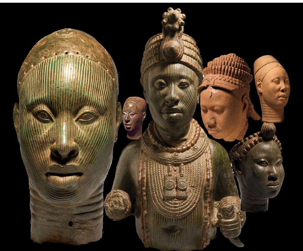
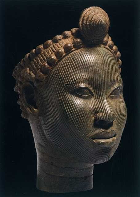
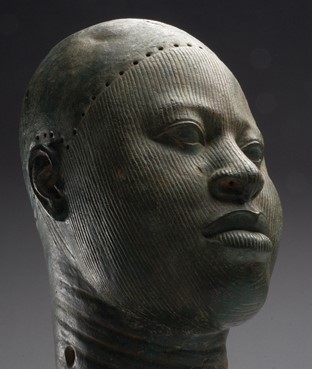
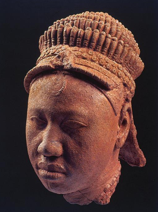
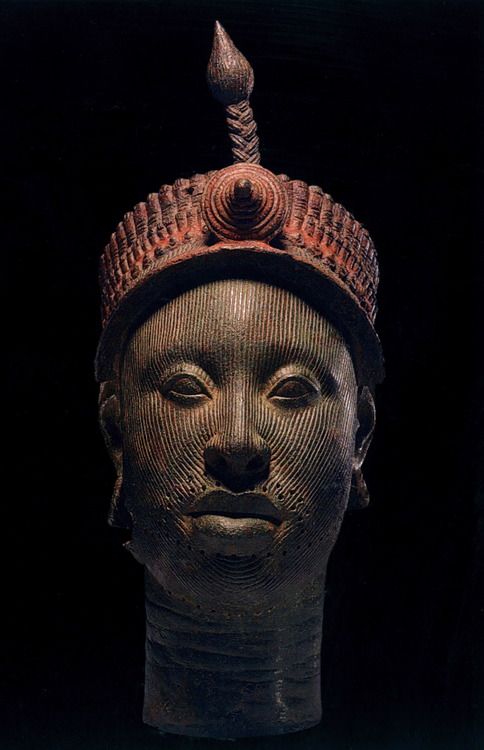
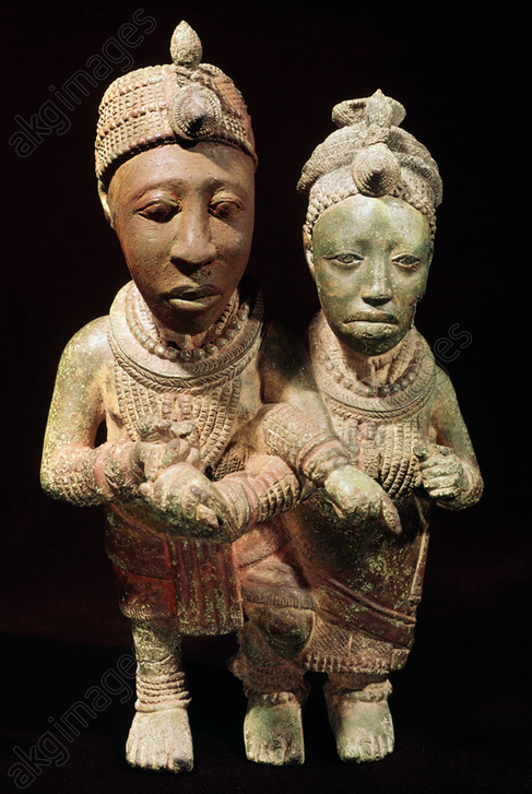
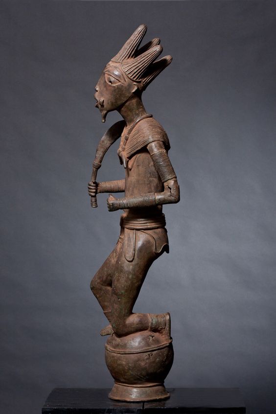
It was in January 1938, during excavation work for the construction of a house, that workers discovered an unusual treasure in the Wunmonije district of Ife. At a mere hundred meters distance away of the site of what once was the Royal Palace, they unearthed thirteen magnificent bronze heads dating from the XIIth century representing a king (an « Ooni« ), some women and courtiers. Others have since been unearthed.
Their faces, except for the lips, are covered with grooves. The hairstyle suggests a complex crown composed of several layers of tubular balls, topped by a crest with a rosette and an « egret ». The surface of this crown bears traces of red and black paint.
These large heads may have been used as effigies of the deceased in funeral ceremonies, which, among the Yoruba, sometimes took place a year after the rapid burial of the dead imposed by the tropical climate.
At the time of the discovery, the extremely naturalist rendering of the heads is considered anachronistic in the art of sub-Saharan Africa, and even more disturbing than the very “classical” i.e. realistic “mummy portraits” (Ist-IInd century) discovered as early as 1887 in the Faiyum depression of Egypt.
Yet a long tradition of figurative sculpture with similar characteristics as the bronze heads of Ife existed before, particularly among the Nok, a people of farmers who mastered iron metallurgy starting from 800 BC.
Hysteria
Since 1938, the « heads of Ife » have provoked reactions close to hysteria in Europe and the West in general.
On the one hand, the « modernists » and the « abstract » artists of the early XXth century, for whom the more abstract a sculpture is and the more distant it is from reality, the more it was considered as typically African. For those who were inspired by African « abstract » art to free themselves from what they considered as materialistic naturalism, the heads of Ife brutally challenged their self-deceiving “smart” narrative.
On the other hand, especially for the supporters of colonial imperialism, this art simply could not be. Frank Willett, at one point the head of the Nigerian Department of Antiquities and author of Ife, an African civilization (Editions Tallandier, 1967), reported that « Europeans visiting Ife frequently wonder how people living in houses of dried mud, with straw roofs, could have made such beautiful objects as the bronzes and terracotta in the museum ». Trying to answer that question, the publisher Sir Mortimer Wheeler replied: “The prejudice is alive and well that artistic creation and sensitivity cannot exist without domestic talent and sanitary comfort!”
The questions of the Europeans were numerous. How, in the XIIth century, could primitive peoples, who had never known an organized form of state, have made bronze heads of such refinement, using techniques that even Europe failed to master at that juncture? How could it have been possible, for tribes, subjected to superstition and irrational magic, could have observed the human anatomy so meticulously? How could savages have expressed such noble feelings towards both men and women? Faced with such an unbearable paradox, total denial was their only answer.

Hence, when the German archaeologist Leo Frobenius presented the bronze heads, western experts refused to believe in the existence of an African civilization capable of leaving artifacts of a quality they recognized as comparable to the best artistic achievements of ancient Rome or Greece. In a desperate attempt to explain what passed for an anomaly, Frobenius, without the slightest semblance of proof, came up with the theory that these heads had been cast by a Greek colony founded in the XIIIth century BC, and that the latter could be at the origin of the old legend of the lost civilization of Atlantis, a narrative immediately adopted in chorus by the mass media…
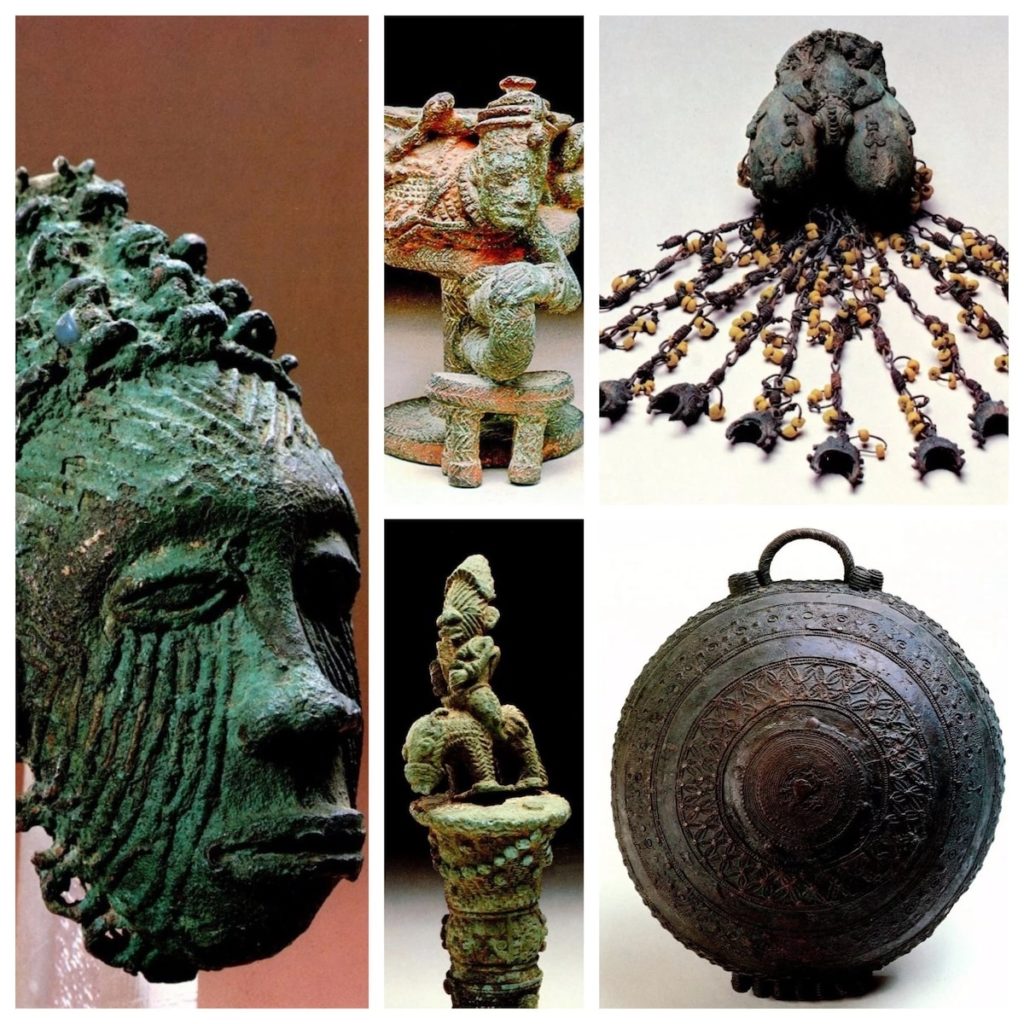
Bronze
What first shocked Western experts was that these were not carved wood but sophisticated bronze heads (about 70 % copper, 16.5 % zinc and 11.3 % lead).
Given the extreme scarcity of copper ore in Nigeria, these objects demonstrate that the region had trade relations with distant countries. The ore is believed to have come from Central Europe, northwest Mauritania, the Byzantine Empire or, via the Niger River, from Timbuktu where the ore arrived by camel from southern Morocco.
If during the Neolithic period, copper, gold and silver nuggets were hammered cold or hot, it is only starting from the Bronze Age that man develops the science of real metallurgy. From ores, he was then able to extract metals thanks to a precise heat treatment, made possible by the experience of the ceramists of the time, great experts in the construction of high temperature ovens.
Copper only melts at 1083° Celsius, but by adding tin (which melts at 232°) and lead (which melts at 327°), it is possible to obtain bronze at 890° and brass at 900°. The terracotta is made at low temperature, around 600 to 800°. It should be underlined that in China, since the Shang Dynasty (1570-1045 BC), certain types of porcelain obtained much higher temperatures, between 1000 and 1300° Celsius, obtained thanks to the use of charcoal.
The oldest traces of ceramics in sub-Saharan Africa are thought to date back to more than 9000 BC, and perhaps earlier. Bu some fragmentary shards have been discovered in West Africa, in this case in Mali, and considered dating from 12000 BC. Ceramics also were produced further south, notably by the Nok culture in northern Nigeria at the beginning of the first millennium BC.
Lost-wax casting
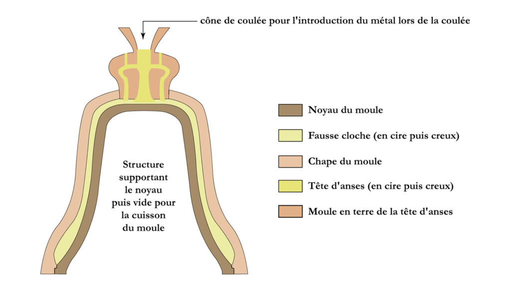
What also shocked the experts was that the technique used to make them was the quite sophisticated so-called « lost-wax casting » or “cire perdue” technique, a high precision molding process that is still used today to make church bells.
First, a model was made out of wax. This was covered with fine clay to form a mold, which was then heated so that the wax melted and ran away. Molten metal was poured into the clay mold which would be broken open to release the complete object.
Clearly, the foundries producing these artifacts required a highly skilled and well organized professional labor force.
The exceptional know-how and skills of the bronze founders of Ife was preceded by those of Igbo-Ukwu in eastern Nigeria where in 1939 a tomb filled with artifacts dating from the IXth century was discovered, revealing the existence of a powerful and refined kingdom mastering the famous lost-wax casting technique, but which so far could not be linked to any other culture in the region.
The oldest known example of the lost-wax technique comes from a 6,000-year-old wheel-shaped copper amulet found at Mehrgarh in today’s Pakistan. Although China, Greece and Rome mastered this technique, it was not until the Renaissance that it made its return to Europe.
Ife, an organized state
In reality, the art of Ife challenged the colonial theory that Africa was a virgin land, populated by animals and a few primitive tribes who had never taken their first steps in « history ».
Indeed, any evidence showing the existence of empires, kingdoms or great states on the African continent that allowed Africans to govern themselves peacefully for centuries could only de-legitimize the « civilizing mission » of colonialism.
However, according to oral traditions, Ife was founded in the 9th-10th centuries by Oduduwa, through the fusion of 13 villages into a single city becoming the hearth of Yoruba mythology, who considers Ife as the cradle of humanity and the center of the world.
Recognized as a minor god, Oduduwa became the first Ooni (King) and had an Aafin (palace) built. He ruled with the help of the isoro, former village chiefs who had recovered a religious title and were subject to royal political authority.
According to the same oral traditions, Oduduwa is said to have been an exiled Prince of a foreign people, who left his homeland and traveled south with his suite, settling among the Yoruba around the XIIth century. His religious faith, that he brought with him, was so important to him and his followers that it would have been the cause of their exodus in the first place.
Oduduwa’s land or country of origin remains a matter of debate. For some, he comes from Mecca, for others from Egypt, as the technical skills he brought with him are supposed to demonstrate.
So far, most historians have looked to influences arriving by sea and waterways. However, it is a very plausible hypothesis that travel routs through the savanna, could have connected the Niger Delta with the Nile, like a sort of great transcontinental land-bridge, passing notably via Chad, a region where thousands of early cave paintings testify the vivacity of pictorial creativity.
As our good friend Kotto Essomé repeatedly underlined, African states often prospered along the climatic zones, following “horizontally” the latitudes. Colonial borders were deliberately drawn (laterally or “vertically”) to break the natural boundaries of pre-colonial African states.
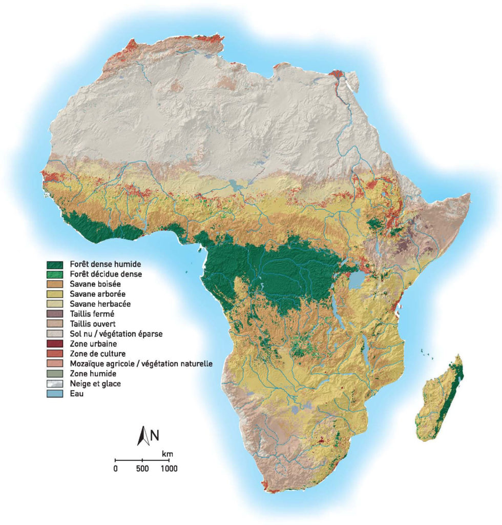
Now, as this map clearly indicates, a horizontal “ribbon” of habitable urban areas, on the borderline between the herbaceous and wooded savanna, stretches over the entire continent from the Atlantic till the Southern Nile. Unsurprisingly, this particular climatic and geographical area might have been optimally suited for both hunting, agriculture and cattle raising.
From their part, the Edo people of Benin City believed that Oduduwa was in fact a prince of their extraction, who would have fled Benin during a fight over royal succession. This is why one of his descendants, Prince Oramiyan, would have been allowed to return and found the dynasty ruling the Kingdom of Benin. Prince Oramiyan was thus the first oba of Benin, successfully replacing the Ogiso monarchical system that had reigned until then.
Metallurgy
What deserves attention here is the fact that metallurgy occupies a central place in Ife. Oduduwa had a forge in his Royal palace (Ogun Laadin). Kings from different kingdoms installed their forges within the royal palace, showing the strong symbolic relationship between power and metallurgy.
Contrary to what happened on other continents, the Iron Age in Africa would have preceded the Copper Age in some regions. The oldest indications documenting the transformation of iron ore in Africa date back to the third millennium BC. They are the archaeological sites of Egaro in eastern Niger and Giza and Abydos in Egypt. While the site of Buhen in Egyptian Nubia (- 1991), after working iron, became a « copper factory », the sites of Oliga in Cameroon (-1300) and Nok in Nigeria (-925) testify clearly of a dynamic metallurgical activity.
As we have seen, bronze casting techniques demonstrate the existence of a very advanced technological know-how. Ife will also be a major center for glass production, especially glass beads. The waste material of this ancestral production, made up of parts of crucibles covered with molten glass, will be looked for in the XIXth century by the inhabitants of the region, although the origin of the glass beads was neglected.
Recent archaeological excavations have shown that the settlements of this area are very ancient. But as we have seen, it was only at the beginning of the 2nd millennium that developments in the field of metallurgy would have made it possible to improve agricultural tools and generate surplus food. Yam, cassava, maize and cotton are cultivated here, the latter giving birth to an important cloth weaving industry.
Hence, the city of Ife experienced a rapid demographic expansion thanks to this rise in agricultural productivity, itself the fruit of the mastery of an increased energy density allowing the transformation of « stones » (ores) into useful resources.
The medieval urbanization of Ife is today widely attested by the existence of numerous enclosures made of ditches and embankments, which seem to indicate the various spaces that have experienced a demographic concentration and the existence of a political body powerful enough to implement such great infrastructure programs.
Interesting, as a successful centralized state, Ife became increasingly a model for other states in the region and beyond. Several descendants and captains of Oduduwa founded their own kingdoms based on the same model and relying on the same legitimacy. The monarchical experience of Ife is exported with its cultural framework. The adé ilèkè, a crown of glass beads symbolizing royal power, is found in most monarchies in the region.
In total, depending on the sources, an estimated 7 to 20 kingdoms make up the Yoruba world in the first half of the second millennium AD.
- Oyo State in Nigeria was one of such powerful Yoruba city-states.
- Another example, the Kingdom of Ketou, currently in the southeast of Benin, is supposed to have been founded around the XIVth century by an alleged descendant of Oduduwa. He is said to have left Ife with his family and other members of his clan and moved westward, eventually settling in the city of Aro, northeast of the city of Ketou. Aro quickly became too small for the growing population, and the decision was made to settle in Ketou. King Ede therefore left Aro with 120 families and settled in this city.
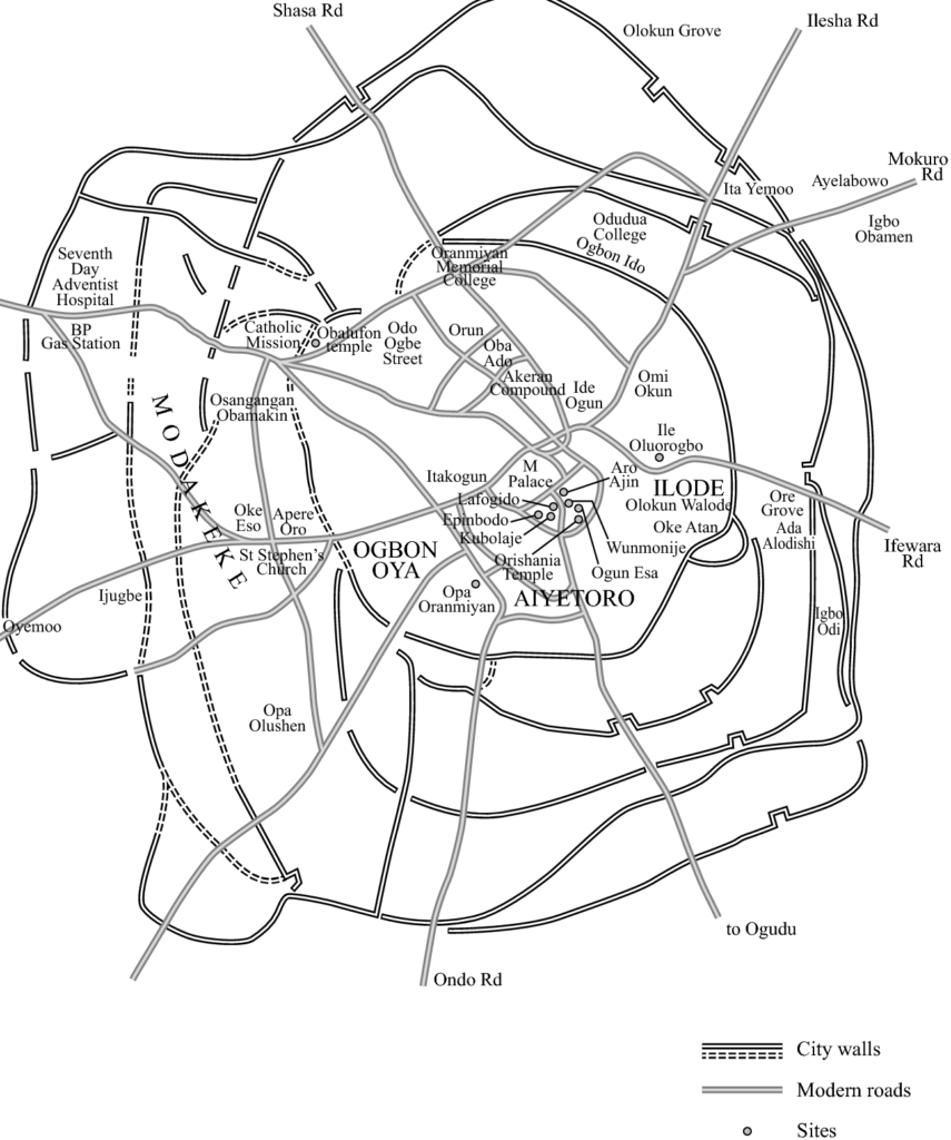
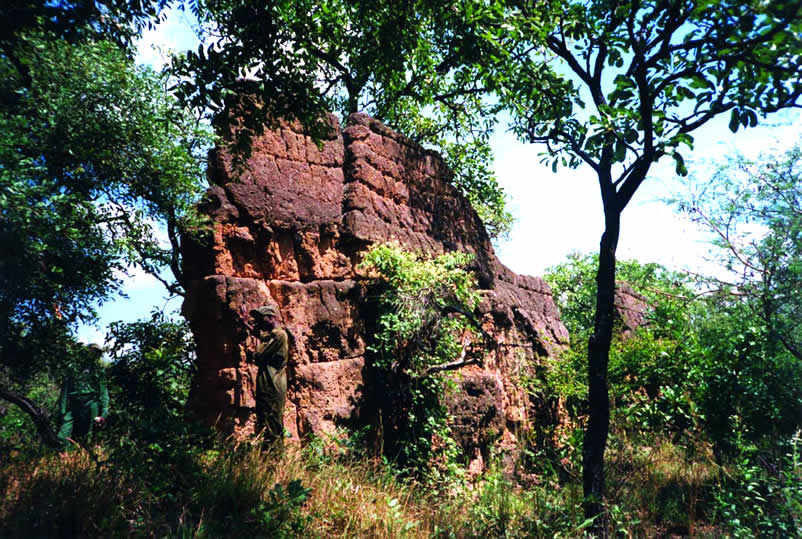
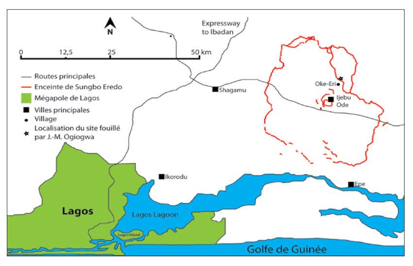
- Another demonstration of Yoruba building science is the Sungbo Eredo Wall, near the Nigerian capital Lagos, a system of walls and ditches built in the XIVth century and located southwest of the town of Ijebu Ode, in Ogun State, southwestern Nigeria. More than 160 km (100 miles) long, these fortifications, some as high as 20 meters (65 feet), consist of a smooth-walled ditch that forms an inner moat in relation to the walls that overhang it. The ditch forms an irregular ring (Map) around the lands of the ancient kingdom of Ijebu. This ring is about 40 km in the north-south direction and 35 km in the east-west direction, which is the equivalent of the Paris périphérique ! Invaded by vegetation, the construction today looks like a green tunnel.
From Ife to the Kingdom of Benin
In the XIVth century, Ife experienced a demographic collapse, characterized by the abandonment of certain enclosures and a strong advance of the forest into formerly residential areas. There was also a break in the transmission of know-how and artisan techniques.
This demographic collapse has been explained as the result of a Black Plague, according to some authors, who draw a parallel with the pandemic waves hitting Europe at the same period.
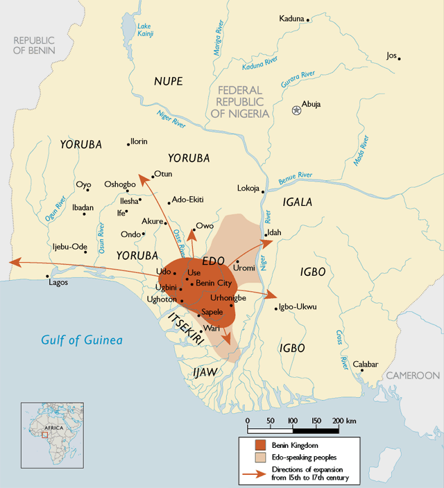
Part of the inhabitants of Ife were able to take refuge and bring their know-how in metallurgy to the Kingdom of Benin, which lasted for seven hundred years, from the XIIth century until its invasion by the British Empire at the end of the XIXth century. Benin was a coastal West African city-state dominated by the Edos, an ethnic group whose dynasty still survives today.
Its territory covers to present-day Benin, plus part of Togo and southwestern Nigeria, where today « Benin City », a historic port on the Benin River, is located. In the heart of the city, the royal residence with monumental proportions translated visually the importance given to political, spiritual and traditional power.
Benin City, a marvel
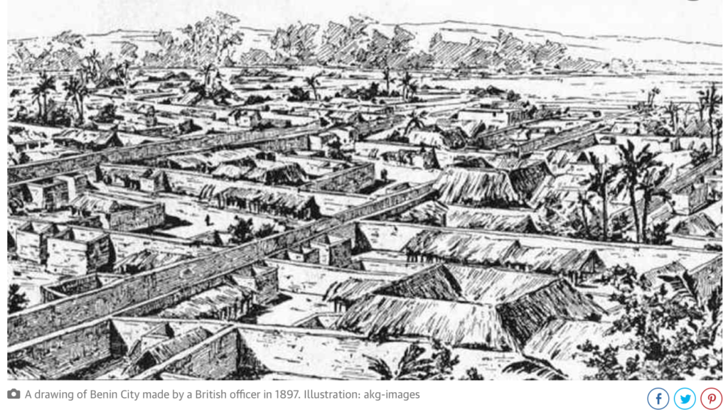
The social organization of the city impressed European visitors at the end of the XVth century. As a major regional economic trading pole, Benin was full of ivory, pepper and slaves. Benin offered the Europeans palm oil (the oil palm growing abundantly in the region). In exchange, they requested, and obtained guns, allowing the modernization of the Beninese armament.
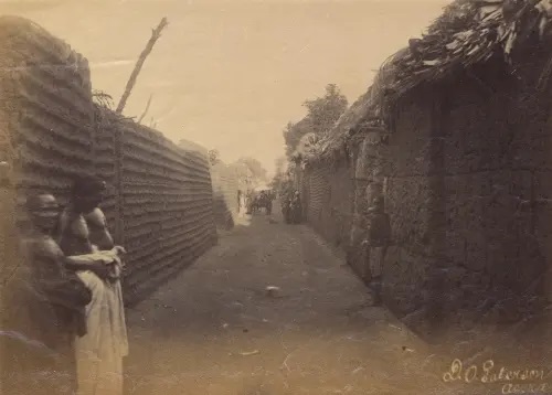
Located in a plain, Benin City is surrounded by massive walls to the south and deep ditches to the north. Beyond the city walls, many other walls have been erected that organize the entire region of the capital into some 500 separate boroughs.
In 2016, an article published by The Guardian recounted the lost splendor of the city. The paper reported:
“The Guinness Book of Records (1974 edition) described the walls of Benin City and its surrounding kingdom as the world’s largest earthworks carried out prior to the mechanical era. According to estimates by the New Scientist’s Fred Pearce, Benin City’s walls were at one point “four times longer than the Great Wall of China, and consumed a hundred times more material than the Great Pyramid of Cheops”.
Pearce writes that these walls “extended for some 16,000 km in all, in a mosaic of more than 500 interconnected settlement boundaries. They covered 6,500 sq km and were all dug by the Edo people … They took an estimated 150 million hours of digging to construct, and are perhaps the largest single archaeological phenomenon on the planet”.
Benin City was also one of the first cities to have a semblance of street lighting. Huge metal lamps, many feet high, were built and placed around the city, especially near the king’s palace. Fueled by palm oil, their burning wicks were lit at night to provide illumination for traffic to and from the palace.
When the Portuguese first “discovered” the city in 1485, they were stunned to find this vast kingdom made of hundreds of interlocked cities and villages in the middle of the African jungle.
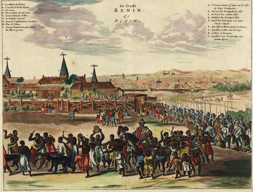
In 1691, the Portuguese ship captain Lourenco Pinto observed:
“Great Benin, where the king resides, is larger than Lisbon; all the streets run straight and as far as the eye can see. The houses are large, especially that of the king, which is richly decorated and has fine columns. The city is wealthy and industrious. It is so well governed that theft is unknown and the people live in such security that they have no doors to their houses.”
In contrast, London at the same time is described by Bruce Holsinger, professor of English at the University of Virginia, as being a city of “thievery, prostitution, murder, bribery and a thriving black market made the medieval city ripe for exploitation by those with a skill for the quick blade or picking a pocket”.
African fractals
Benin City’s planning and design was done according to careful rules of symmetry, proportionality and repetition now known as fractal design. The mathematician Ron Eglash, author of African Fractals – which examines the patterns underpinning architecture, art and design in many parts of Africa – notes that the city and its surrounding villages were purposely laid out to form perfect fractals, with similar shapes repeated in the rooms of each house, and the house itself, and the clusters of houses in the village in mathematically predictable patterns.
As he puts it:
“When Europeans first came to Africa, they considered the architecture very disorganized and thus primitive. It never occurred to them that the Africans might have been using a form of mathematics that they hadn’t even discovered yet.”
At the center of the city stood the king’s court, from which extended 30 very straight, broad streets, each about 120-ft wide. These main streets, which ran at right angles to each other, had underground drainage made of a sunken impluvium with an outlet to carry away storm water. Many narrower side and intersecting streets extended off them. In the middle of the streets were turf on which animals fed.
“Houses are built alongside the streets in good order, the one close to the other,” writes the XVIIth-century Dutch visitor Olfert Dapper. “Adorned with gables and steps … they are usually broad with long galleries inside, especially so in the case of the houses of the nobility, and divided into many rooms which are separated by walls made of red clay, very well erected.”
Dapper adds that wealthy residents kept these walls “as shiny and smooth by washing and rubbing as any wall in Holland can be made with chalk, and they are like mirrors. The upper stores are made of the same sort of clay. Moreover, every house is provided with a well for the supply of fresh water”.
Family houses were divided into three sections: the central part was the husband’s quarters, looking towards the road; to the left the wives’ quarters (oderie), and to the right the young men’s quarters (yekogbe).
Daily street life in Benin City might have consisted of large crowds going though even larger streets, with people colorfully dressed – some in white, others in yellow, blue or green – and the city captains acting as judges to resolve lawsuits, moderating debates in the numerous galleries, and arbitrating petty conflicts in the markets.
The early foreign explorers’ descriptions of Benin City portrayed it as a place free of crime and hunger, with large streets and houses kept clean; a city filled with courteous, honest people, and run by a centralized and highly sophisticated bureaucracy.

The city was split into 11 divisions, each a smaller replication of the king’s court, comprising a sprawling series of compounds containing accommodation, workshops and public buildings – interconnected by innumerable doors and passageways, all richly decorated with the art that made Benin famous. The city was literally covered in it.
The exterior walls of the courts and compounds were decorated with horizontal ridge designs (agben) and clay carvings portraying animals, warriors and other symbols of power – the carvings would create contrasting patterns in the strong sunlight. Natural objects (pebbles or pieces of mica) were also pressed into the wet clay, while in the palaces, pillars were covered with bronze plaques illustrating the victories and deeds of former kings and nobles.
At the height of its greatness in the XIIth century – well before the start of the European Renaissance – the kings and nobles of Benin City patronized craftsmen and lavished them with gifts and wealth, in return for their depiction of the kings’ and dignitaries’ great exploits in intricate bronze sculptures.
“These works from Benin are equal to the very finest examples of European casting technique,” wrote Professor Felix von Luschan, formerly of the Berlin Ethnological Museum. Italian Renaissance artist “Benvenuto Celini could not have cast them better, nor could anyone else before or after him. Technically, these bronzes represent the very highest possible achievement.”
The fatal encounter with « civilization »
Following the Berlin Conference of 1885, where the British, Portuguese, Belgian, German, French, Italian and other European colonial powers shared Africa like a big chocolate cake that they intended to devour, in the name of the immutable laws of the freshly invented science of “geopolitics”, European invasions multiplied and gained in brutality.
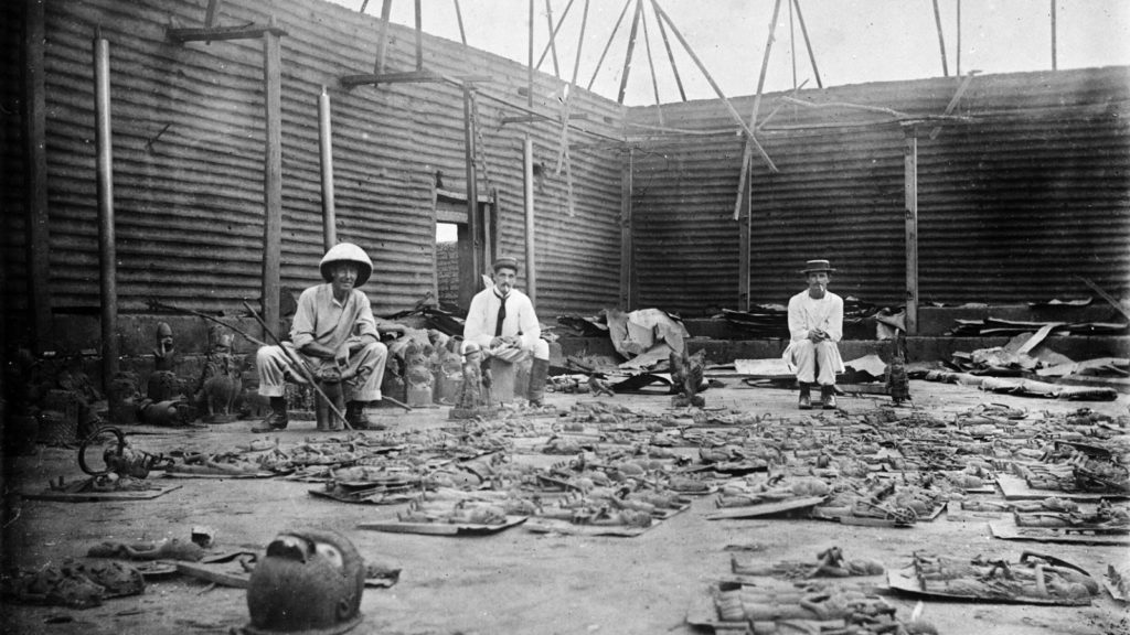
Thus, following the king of Benin’s refusal to cede to the British the national monopoly on the production of palm oil and other products, Benin City was looted, burned and reduced to ashes during a British punitive expedition in 1897. The king (the oba) is arrested and forced into exile and thousands of beautiful « bronzes of Benin », though less realistic than those of Ife, are stolen, sold and partly lost.
They end up on the art market and in museums, including the British Museum (700 objects) and the Berlin Museum of Ethnology (500 pieces). The British government itself sells some of them « to cover the cost of the expedition« .
So, while some clearly entered history with their beautiful art, others exited civilization with their barbarian crimes.
Summary bibliography:
- Ifè, une civilisation africaine, Frank Willett, Jardin des Arts/Tallandier, Paris 1971;
- General History of Africa, Présence africaines/Edicef/Unesco, Paris 1987;
- Atlas historique de l’Afrique, Editions du Jaguar, Paris 1988;
- L’Afrique ancienne, de l’Acus au Zimbabwe, under the direction of François-Xavier Fauvelle, Belin/Humensis, Paris 2018.