Étiquette : Romorantin

The challenging modernity of the Indus Valley Civilization

Get an easy-to-print pdf file of this article
Karel Vereycken, Paris, France, January 2023
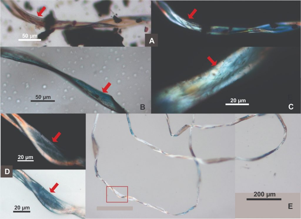
A major archaeological discovery has just been made in Israel in 2022: the first evidence of the use of cotton fibers in the Near East and among the oldest in the world, dating back nearly 7,000 years, was discovered by Israeli, American and German archaeologists during an archaeological excavation at Tel Tsaf, southeast of Beit She'an, in the Jordan Valley of Israel.
So far, the earliest available evidence of cotton fibers in the area was dated to a few hundred years later, to the late Chalcolithic (Copper Age) and Early Bronze Age (about 5,000 to 6,500 BCE) from the archaeological site of Dhuweila in eastern Jordan.
Discovered in 1940, the site of Tel Tsaf reveals its secrets. « Tsaf is characterized by an amazing preservation of organic materials, » said Professor Danny Rosenberg of the Zinman Institute of Archaeology at the University of Haifa. « Tel Tsaf was a kind of pole that concentrated important commercial activities and had established contacts with many other peoples, » Rosenberg believes. « There was massive storage capacity there to accommodate grain, enormous capacity if you compare it to other sites.
For example, the earliest evidence of the social use of beer drinking and ritual food storage has been found there. Rosenberg and the other researchers also found beads from contemporary Anatolia, Romania, Egypt and other parts of Africa; pottery from Iraq, Syria and Armenia; and the earliest copper and other metals found in the world.
“Wool Tree” and “Cotton Roads”
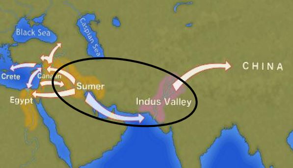
The cotton found in Israel, probably came from the Indus region—modern Pakistan/India—which was the only place in the world that had begun to domesticate cotton at that time before its cultivation appeared in Africa thousands of years later.
« What’s interesting about this early evidence of a link to such a distant region is that it comes from fibers – microscopic pieces of ancient yarn. We assume that these cotton fibers, found along with wool fibers and plant fibers, arrived at the site as part of fabrics or clothing, i.e., ancient textiles, » Rosenberg says.
In addition, cotton was not only used for clothing: « In the prehistoric era, textiles were involved in many areas of life, not only in clothing but also in hunting, fishing … This is much more important than just saying that what we found are pieces of clothing that were worn by the inhabitants of the area. This discovery tells us a lot about the economic practices of the area, » says Rosenberg.
Since cotton had never been grown in Tel Tsaf, it was a surprise for the researchers to find it, and they felt that its presence underscored the city’s importance as a global trading hub at the heart of what could be called, the « Cotton Roads » of those days.
Growing cotton poses major challenges: a moderate to tropical climate and vast amounts of water. Just to produce a single T-shirt and a pair of jeans (representing about 1 kg of cotton), no less than 20,000 liters of water are required! Which civilization can afford such a performance at the beginning of the 7th millennium BC?
The Indus Valley civilization (IVC)
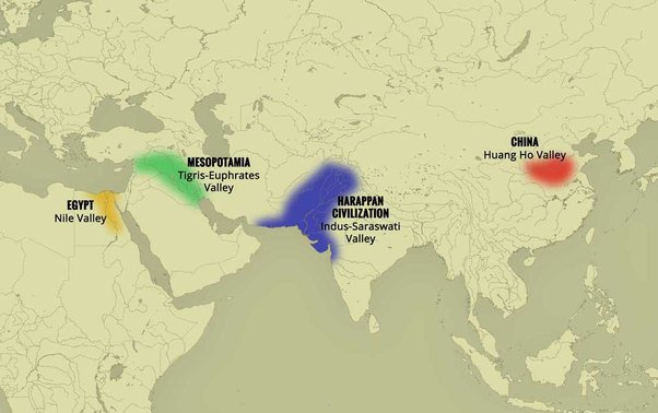
The term « Indus Valley Civilization » (IVC) refers to a vast cultural and political entity that flourished in the northern region of the Indian subcontinent between about 8000 and about 1900 BCE., a region that stretched from Baluchistan (Pakistan) in the west to Uttar Pradesh (India) in the east and from northeastern Afghanistan in the north to Gujarat (India) in the south.
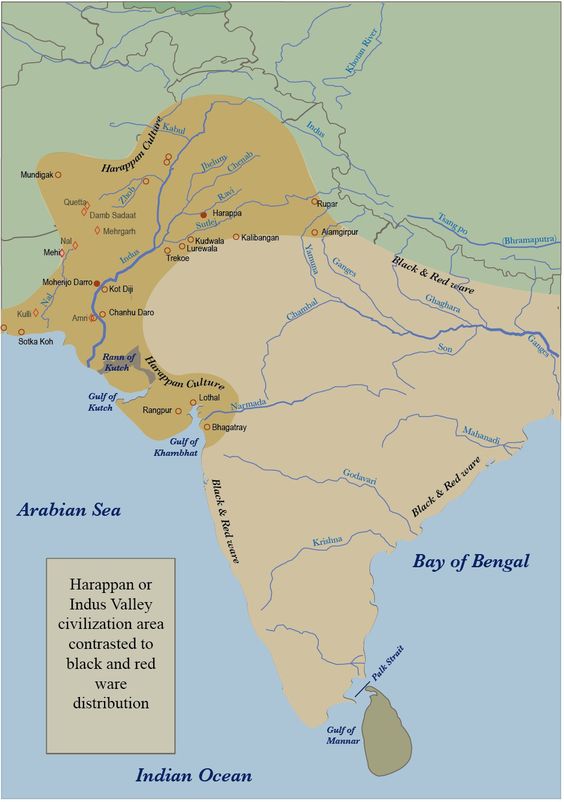
In the absence of both literary sources and remnants of palaces and temples to confirm it, one cannot qualify this entity as a “Kingdom” or an “Empire”. Its modern name (IVC) derives simply from its location in the Indus Valley, but also goes under the name of the « Indus-Sarasvati civilization » or « Harappan civilization ». These last designations come from the river Sarasvati, mentioned in the Vedic sources, which flowed next to the Indus and which would have disappeared, and from the ancient city of Harappa (Punjab, Pakistan), discovered by the British in 1829, but deliberately left unexplored.
The rise of a great urban civilization in the Indus Valley, which reached its maturity around 2500-2400 BCE, was long considered a sudden and mysterious phenomenon. Today, a series of discoveries allows us to follow, from 7000 to 2500 BCE, a series of transformations and innovations whose cumulative effects, stimulated by the enlargement of the network of exchanges from 3000 BCE onwards, created the conditions for the development of an incredibly modern and prosperous urban civilization.
Enter Mehrgarh, the light of the world!
Since prehistoric times, the Indus region has been pioneering and rich in discoveries. As an example, for the Guinness Book of Records, although a case apart, the farming village of Mehrgarh (Baluchistan, Pakistan) which dates from the Neolithic (using only stones as tools) but can be considered as the key culture and city that lead humanity, as early as in the 8th millennia BCE, from the Stone Age into the Age of Copper.
The site is located on the principal route between what is now Afghanistan and the Indus Valley: this route was also undoubtedly part of a trading connection established quite early between the Near East and the Indian subcontinent.
Excavations in Mes Aynak (Afghanistan), where archaeologists are only beginning to find remnants of a 5,000-year-old Bronze Age site beneath the Buddhist level, including an ancient copper smelter, will undoubtedly shed new light on these relationships.
On the basis of a variety of well-documented archaeological finds, it has been established that “pre-Harrapan” Mehrgarh, made several historical breakthroughs for the benefit of humanity as a whole.
Mehrgarh gave the world:
- among the oldest traces of agriculture (wheat and barley) and breeding (cattle, sheep and goats) in South Asia ;
- the first breweries (with wheat and barley);
- the oldest reservoirs for irrigated agriculture and flood prevention;
- the oldest traces of cotton culture (6th millennium BCE);
- the oldest jewel, called the « Mehrgarh amulet » (6th millennium BCE), produced with the « lost wax » bronze casting technique ;
- the oldest bow drills (in green jasper) allowing to drill holes in lapis lazuli and carnelian;
- the very first traces of successfull dentistry practices (!) (9th millennium BCE); The inhabitants of Mehrgarh appeared to have developed an understanding of surgery and dentistry, as evidenced by the drilled teeth of some of the skeletons found at the site. Analysis of the teeth shows that prehistoric dentists worked to treat toothaches with drills made from flint heads. The work was so elaborate that even modern dentists are surprised at the efficiency with which the Mehrgarh « dentists » removed decaying tooth tissue. Among the remains, a total of eleven drilled crowns were found, with one example showing evidence of a complex procedure involving the removal of tooth enamel followed by carving of the cavity wall. Four of the teeth show evidence of decay associated with the drilled hole. None of the individuals with drilled teeth appear to have come from a special tomb or shrine, indicating that the oral health care they received was available to all.

Densely populated
Originally, the IVC was built around the fishy meanders of the Indus, a river nearly 3200 kilometers long that flows from the Himalayan mountains towards the Arabian Sea. Like the populations of other great river valleys, this society was seduced by the fertility of the land as well as by the possibility of using the Indus as a transportation route.
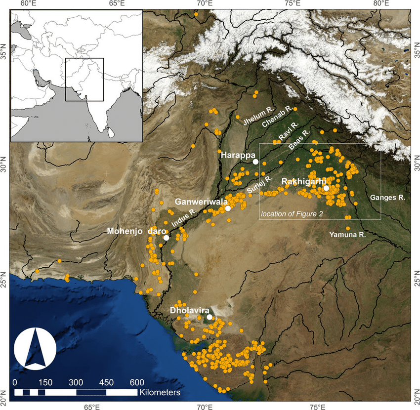
The IVC, whose prosperity rests largely on the increasingly systematic exploitation of the rich silt of the Indus, spread over an immense territory encompassing the entire Indus Valley and part of Indian Gujarat. It is necessary to add to the vast zone of distribution of the Indus civilization some Harappan « colonies » or outposts like Sutkagan Dor (Ballochistan, Pakistan), close to Gwadar on the edges of the sea of Oman, at the Iranian-Pakistani border, and the lapus lazuli mining town of Shortugai, close to Amu Darya river, at the Afghan-Tajik border, at nearly 1,200 kilometers of Mohenjo-daro, by far the largest IVC urban concentration.
At its peak, this civilization was twice as large as the Old Kingdom of Egypt. With an area of 2.5 million square kilometers, it was at the time the largest civilization in the world: it included 5 million people, or 10 % of the world population at the time, much more than less older civilizations as Sumer (0.8 to 1.5 million people) or ancient Egypt (2 to 3 million).
To date, about 2,000 sites have been discovered in India, Pakistan and Afghanistan. Because of various wars and conflicts, only 10 % of the territory of these sites has been excavated and scientifically investigated. On the Indian subcontinent, the main centers of this civilization are Harappa (estimated 23,500 inhabitants) and Mohenjo-daro (est. 40,000 inhabitants) in Pakistan and Lothal, Dholavira and Kalibangan in India. In addition to trade relations with Mesopotamia and Iran, the Harappan city-states also maintained active trade relations with the peoples of Central Asia.
Agriculture, crafts and industry
Agriculture, animal husbandry, industry, trade and commerce were the main source of income.
Agriculture was the main occupation of the people of the Indus Valley. They cultivated barley and wheat on a large scale (and made beer) but also other crops such as legumes, cotton, cereals, sesame, dates, mustard, melons, peas, etc.
There is no real evidence of rice, but a few grains of rice have been found in Rangpur and Lothal.
In the towns of Mehrgarh, Harappa, and Mohenjo-daro, there are remains of large granaries, suggesting that they produced more than they needed and physically stocked cereals and other food products in case of crop failure.
Animal husbandry was another major occupation. Seals suggest that they domesticated cows, buffalos, goats, sheep, pigs, etc. Camels and bullocks were also domesticated and used as beasts of burden. Camel bones have been found in large numbers at many sites, but there is no trace of them on the seals. During the excavation of Surkotado in Gujarat, India, the jawbone of a horse was found. Terracotta figurines representing a horse were found in Nausharo and Lothal.
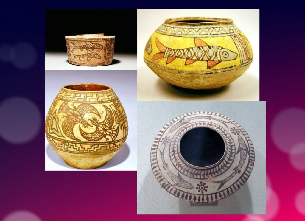
The inhabitants of the Indus Valley were very skillful. They made ceramics, metal vessels, tools and weapons, weaved and spun, dyed and practiced other crafts with potter’s wheels. The weavers wore clothes made of cotton and wool. They knew leather, but there is no record of silk production.
The inhabitants of this civilization originally came from the Bronze Age and used stone tools, but they soon excelled in the manufacture and processing of gold, silver, copper, lead and bronze, especially for artistic ornaments of great finesse.
Artisans made jewelry in Mohenjo-daro, Chanho-daro and Lothal. They used ivory and various precious stones such as carnelian, lapis lazulite, agate and jasper to make them. Shell work was also a thriving industry. Craftsmen in the coastal colonies used shells to make buttons for shirts, pendants, rings, bracelets, beads, etc.
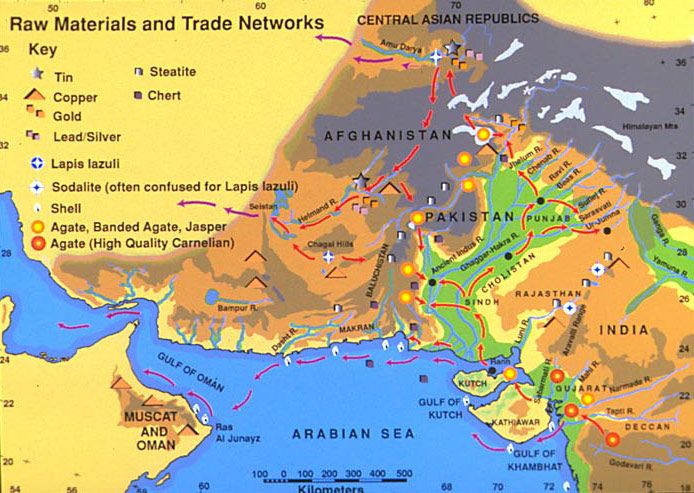
To supply the production of these craft professions, they needed to import various raw materials. To produce bricks and ceramics, clay was available locally, but for metal they had to acquire it from abroad. Trade focused on importing raw materials to be used in Harappan city workshops, including minerals from Iran and Afghanistan, lead and copper from other parts of India, jade from China, and cedar wood floated down rivers from the Himalayas and Kashmir. Other trade goods included terracotta pots, gold, silver, metals, beads, flints for making tools, seashells, pearls, and colored gemstones, such as lapis lazuli and turquoise.
Ox carts were used to transport goods from one place to another. They also constructed barges used on the waterways along the Indus and its tributaries for transportation.
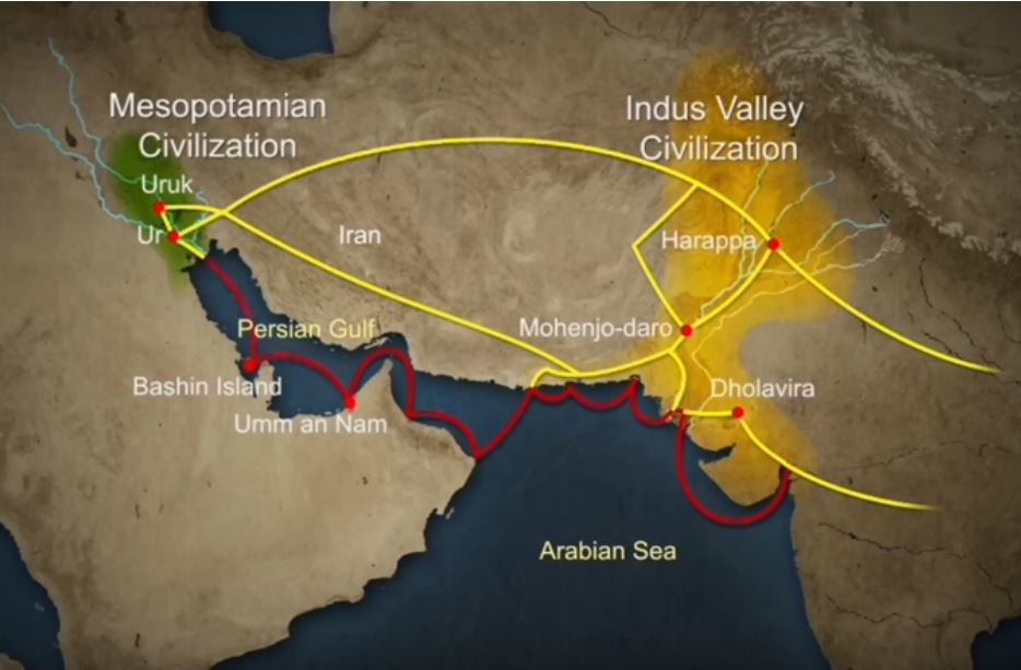
One of the ways historians know about the maritime trade network operating between the Harappan and Mesopotamian civilizations is the discovery of Harappan seals and jewelry at archaeological sites in regions of Mesopotamia, which includes most of modern-day Iraq, Kuwait, and parts of Syria. Long-distance sea trade over bodies of water—such as the Arabian Sea, Red Sea and the Persian Gulf—may have become feasible with the development of plank watercraft that were each equipped with a single central mast supporting a sail of woven rushes or cloth.
Historians have also made inferences about networks of exchange based on similarities between artifacts across civilizations.
Between 4300 and 3200 BCE, ceramics from the Indus Valley Civilization area show similarities with southern Turkmenistan and northern Iran. During the Early Harappan period—about 3200 to 2600 BCE—there are cultural similarities in pottery, seals, figurines, and ornaments that document caravan trade with Central Asia and the Iranian plateau.
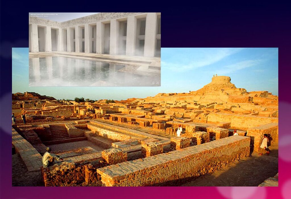
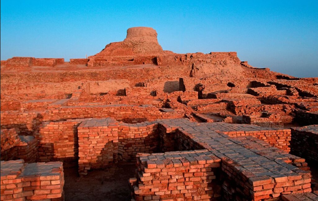
The wonders of Mohenjo-daro
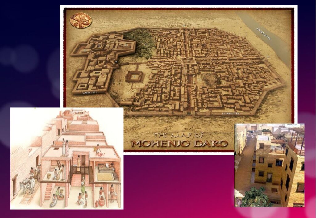
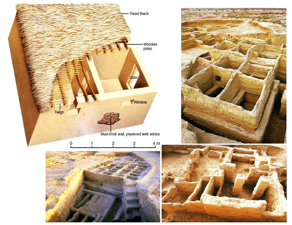
Sometimes referred to as the « Manhattan of the Bronze Age » for the grid pattern of the city plan, Mohenjo-daro (Sind, Pakistan) remained buried under meters of alluvial sediment until 1922.
A real metropolis made of baked bricks, it covers more than 200 hectares. Strictly squared, cut in two by a street of ten meters wide, divided from north to south by a dozen arteries drawn with the cord, and crossed from east to west by paved streets, Mohenjo-daro represents, by its strictly reflected urban framework, the model city of the Indus civilization. It could have accommodated up to 40,000 people!
The Harappans were masters of hydraulic engineering, a “riparian” people working in river corridors practicing irrigated agriculture. They mastered both the shaduf (an irrigation tool used to draw water from a well), and windmills.
In the Harappan cities, the domestic and manufacturing areas were separated from each other.
The inhabitants, living in one-, two-, and sometimes three-story dwellings, seem to have been mainly artisans, farmers, and merchants. The people had developed the wheel, cattle-drawn carts, flat-bottomed boats large enough to carry goods, and perhaps also sailing. In the field of agriculture, they had understood and used irrigation techniques and canals, various agricultural implements, and had established different areas for livestock grazing and cultivation.
Seals and harrapan script
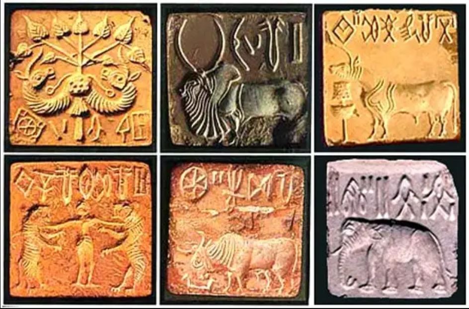
Among the thousands of artifacts found at the various sites are small soapstone seals just over one inch (3 cm) in diameter, used to sign contracts, authorize land sales, and authenticate the point of origin, shipment, and receipt of goods in long-distance trade. On each seal is a small text in Harappan, a language yet to be deciphered.
Among the thousands of artifacts found at the various sites are small soapstone seals just over one inch (3 cm) in diameter, used to sign contracts, authorize land sales, and authenticate the point of origin, shipment, and receipt of goods in long-distance trade.
Commercial contacts between the Indus and Sumer populations are well documented. Numerous seals from the Indus Valley have been discovered in Mesopotamia. On each seal, a small text in Harappean, a language that remains to be deciphered.
If 4,200 texts reached us, 60 % of them are seals or mini-tablets of stone or copper, engraved, and they comprise on average… only five signs! The longest text has 26 signs. The texts are always accompanied by the image of an animal, often a unicorn or a majestic buffalo. They were intended to mark goods, probably indicating the name of the owner or the recipient and a quantity or a year. Trying to decipher the Indus language is a bit like trying to learn French only from the labels on the food shelf of a supermarket!
The invention of sanitation
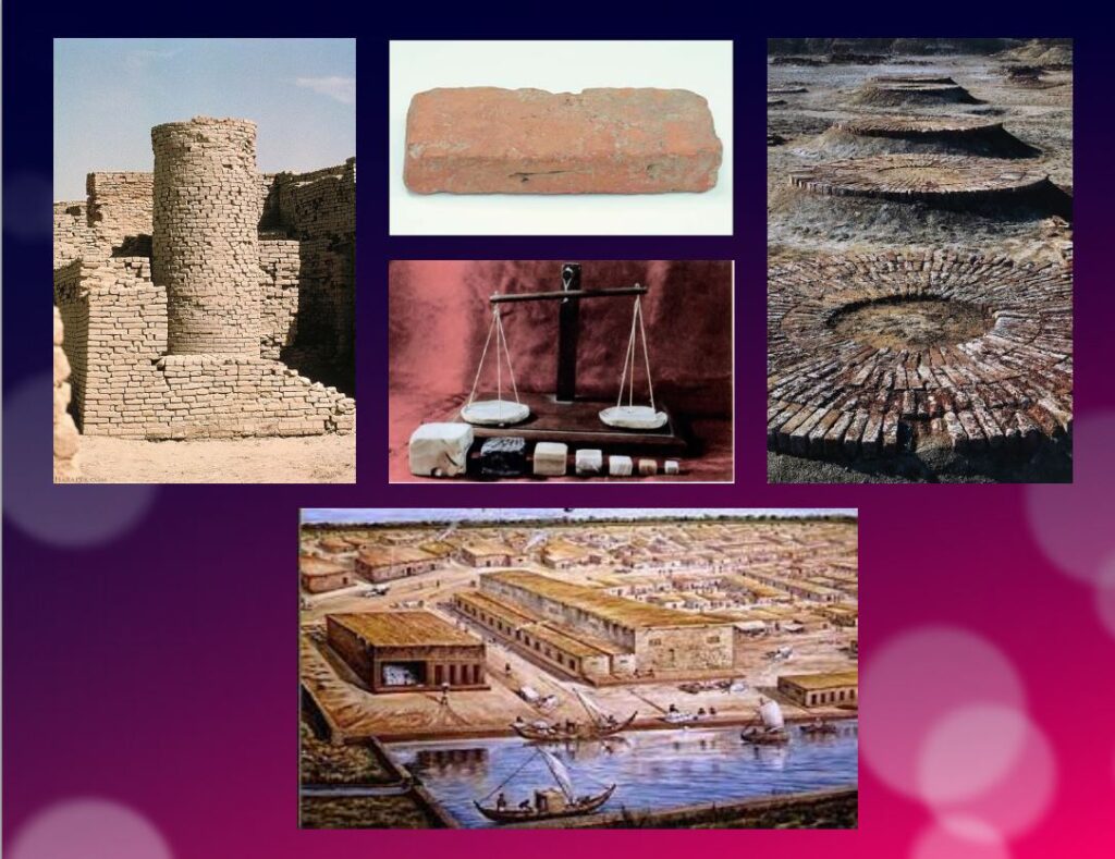
In addition to this particular attention that they paid to urban planning, the members of the Indus civilization also seem to have been pioneers of modern hygiene. Some cities, notably Mohenjo-daro, were equipped with small containers (dustbins) in which the inhabitants could deposit their household waste.
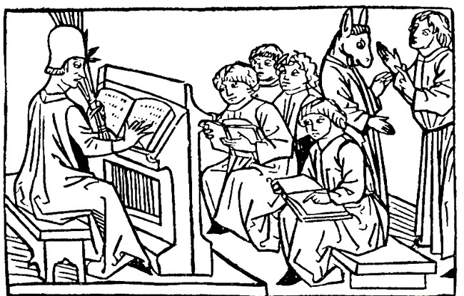
Anticipating our « all to the sewer » systems imagined in the 16th century by Leonardo da Vinci for the project envisaged by François I for the new French capital Romarantin, many cities had already public water supply and an ingenious sanitation system.
In many cities, including Mohenjo-daro, Harappa, Lothal and Rakhigari, individual houses or groups of houses were supplied with water from wells. This quality fresh water was used as much for food and personal hygiene (baths, toilets) as for the economic activities of the inhabitants.
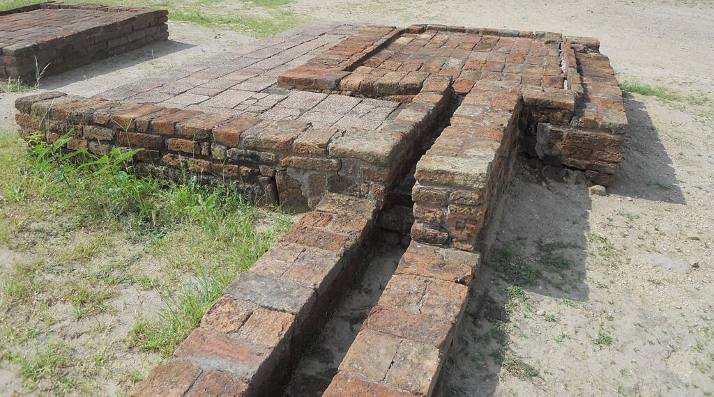
As an example, the sanitation system of the port city of Lothal (Gujarat, India) where many houses had a bathroom and private brick latrines. The wastewater was evacuated through a communal sewer system that led either to a canal in the port, or to a soaking pit outside the city walls, or to buried urns equipped with a hole allowing the evacuation of liquids, which were regularly emptied and cleaned.
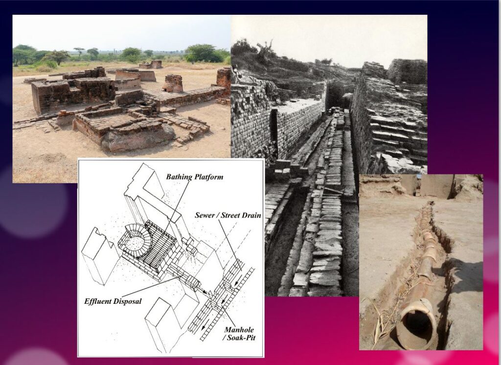
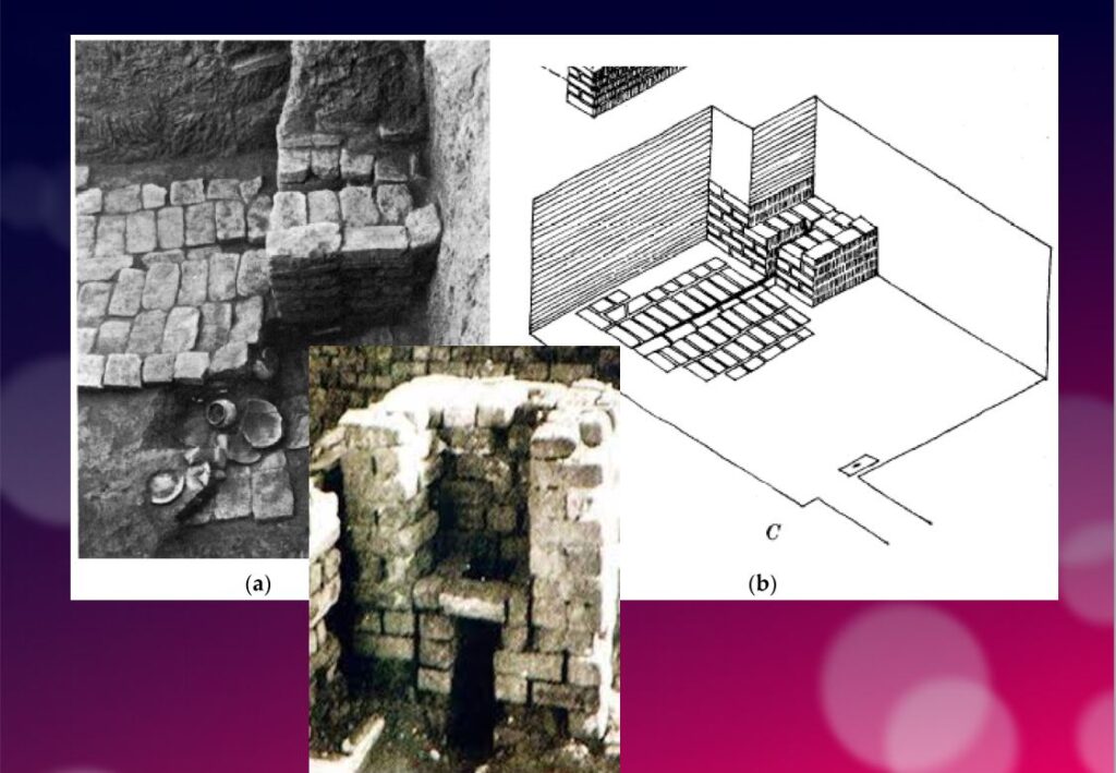
Excavations at the Mohenjo-daro site have also revealed the existence of no less than 700 brick water wells, houses equipped with bathrooms and individual and collective latrines. Toilets were an essential element. However, early archaeologists erroneously identified most toilets as post-cremation burial urns or simple cesspools. Many buildings in the city were two or more stories high. Water from the roof and bathrooms of the upper floors was channeled through closed clay pipes or open troughs that emptied, if necessary via the toilets, into the covered sewers underneath the paved street.
This extraordinary achievement is confirmed by a 2016 scientific study, entitled « The Evolution of Toilets Around the World Across the Millennia, » which reports that,
The earliest multi-flush toilets connected to a sophisticated sewage system that have been identified so far were found in the ancient cities of Harappa and Mohenjo-Daro in the Indus Valley, dating from the middle of the third millennium BC. Nearly every dwelling unit in Harappa, Mohenjo-Daro, and Lothal was equipped with a private bath-toilet area with drains to carry dirty water into a larger drain that emptied into the sewer and drainage system.
Till now, it are the Minoan (Crete) civilization and China that have been credited for the first use of underground clay pipes for sanitation and water supply. In the Cretan capital Knossos, there was a well-organized water system to bring in clean water, to evacuate wastewater and to provide storm sewers for overflow in case of heavy rains.
In Knossos existed also one of the earliest uses of flush toilets, dating back to the 18th century BCE. The Minoan civilization had stone sewers that were periodically cleaned with clean water. Crete, of course, was a large provider of Copper ore for the entire world in Antiquity and had vast international trade connections.
Religious and cultural worldview
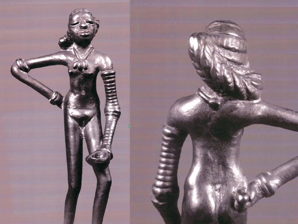
In the IVC, fertility rituals were probably observed in order to promote a full harvest as well as for women’s pregnancies, as evidenced by a number of figurines, amulets and statuettes with female form.
It is thought that the people, like the Dravidians who some believe were the origin of the Indus Civilization, worshiped a “mother goddess” and possibly a male companion represented as a horned figure in the company of wild animals.
The « Great Bath » at Mohenjo-daro would have been used for purification rites related to religious belief, but it could just as easily have been a public pool for recreation. Our knowledge of the religious beliefs of this culture remains in the realm of mere hypothesis.
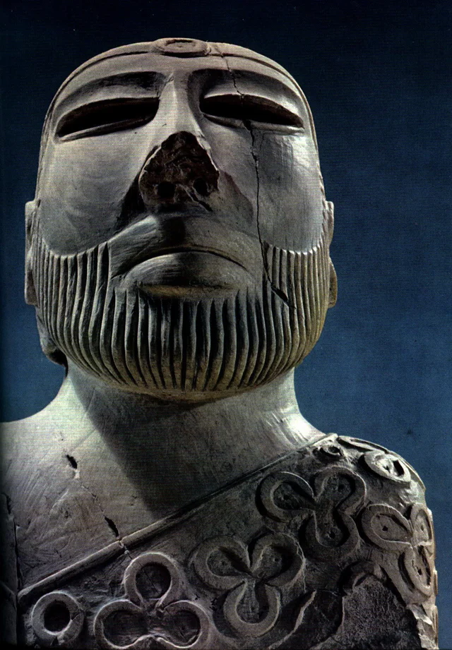
The title of the famous statue of the « Priest-King » found at Mohenjo-daro is misleading, as there is no evidence that it is a king or a priest, and it may be a simple cotton trader…
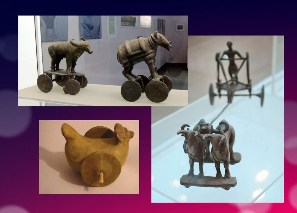
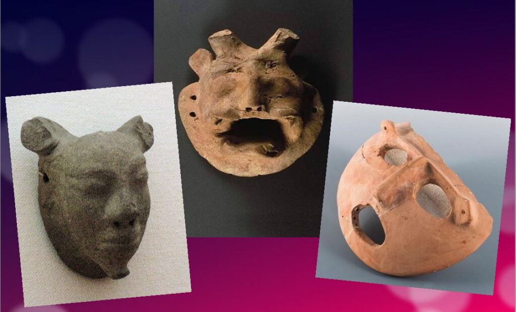
Apart from pottery, certain types of elementary weapons (spearheads, axes, arrows, etc.) and certain tools for practical purposes, two types of artifacts give us cultural clues about Harappean society.
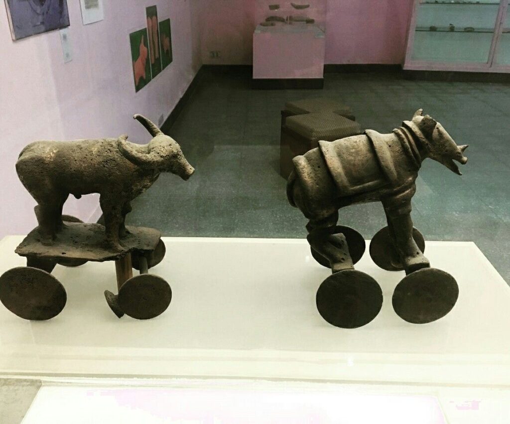
First, some figurines, which we try to interpret as devotional objects, seem to be simple toys. For others, they are clearly toys, notably animals (oxen, buffaloes, elephants, goats and even a simple hen), made of bronze or terracotta, mounted on small carts with wheels.
Second, among other objects expressing a high level of sensitivity and consciousness, a series of masks, some of which seem inspired by Mongolian masks.
These masks are clearly intended to serve comic or tragic representations and remind us of the ancient masks that have come down to us from classical Greece.
Older than Sumer and Egypt?
Archaeological excavations of the IVC got off to a late start, and it is now believed that some of the achievements and « firsts » attributed to Egypt ( – 3150 BC) and Mesopotamia ( – 4500 BC) may in fact belong to the inhabitants of the Indus Valley civilization.
In May 2016, the report published by a team of researchers from IIT Kharagpur, Institute of Archaeology, Deccan College Pune, Physical Research Laboratory and Archaeological survey of India (ASI), published by the journal Nature, shattered a number of “facts” that were considered unshakeable certainties.
Until now, the 900 years of the « mature » phase of the IVC was dated as ranging from 2800 to 1900 BCE. However, the aforementioned Indian study indicates that this civilization was much older than previously thought – it is at least 8,000 years old!
To determine the age of this civilization, researchers dated pottery using a technique called optically stimulated luminescence (OSL) – and found it to be nearly 6,000 years old, the oldest pottery known to date.
Other artifacts have been dated to 8,000 years ago. The results come from a major site excavated at Bhirrana (Haryana, India) that shows the preservation of all cultural levels of this ancient civilization, from the pre-Harappan phase through the Early Harappan to the Mature Harappan period. Bhirrana was part of a high concentration of sites along the mythical Vedic river « Saraswati », now dried up, an extension of the Harki-Ghaggar River in the Thar Desert.
The submerged cities of the Gulf of Khambhat
These new dates converge with the discovery, in January 2002, of ruins of submerged cities in the Gulf of Khambhat (formerly Cambay), off the coast of the state of Gujarat in northwest India.
It is the oceanographers of the National Institute of Ocean Technology (NIOT) of Madras who made this discovery. The team was surveying the muddy sea 30 km off the coast of the state of Gujarat, in the Gulf of Khambhat, to measure the levels of marine pollution. As a routine measure, they recorded acoustic images of the ocean floor.

It was only several months later, while analyzing the data, that the team realized that they had, without knowing it, obtained images of the ruins of a huge city, sunken 40 meters below sea level. And, at the end of January 2002, after having spent weeks to dredge the site and to bring up more than 2 000 objects, the team of the NIOT was able to make extraordinary revelations.
The ruins stretch for 9 km along the banks of an ancient river, and the remains of a dam can be distinguished. The sunken city shares striking similarities with the sites of the Indus civilization. One of the buildings, the size of an Olympic swimming pool, with collapsed steps, recalls the Great Bath of Mohenjo-daro. Another rectangular monument, 200 m long and 45 m wide, is as large as the acropolis discovered at Harappa. The team of NIOT also glimpsed another building, a kind of granary, made of mud bricks, 183 m long. Near these monumental installations, rows of rectangular buildings that resemble the foundations of ruined houses can be seen, and even a drainage system and roads. On another visit to the site, the team recovered polished stone tools, ornaments and figurines, pottery debris, semi-precious stones, ivory and the fossilized remains of a human spine, jaw and tooth. But the team was not at the end of its surprises.
It sent samples of a fossilized log to two major Indian laboratories specializing in dating methods: the Birbal Sbahni Institute of Paleobotany (BSIP) in Lucknow and the National Geophysical Research Institute (NGRI) in Hyderabad. The BSIP dated it to 5500 BCE, while the NGRI dated the sample much earlier, probably to 7500 BCE.
This dating would make Khambhat the oldest site discovered in India. According to some, this discovery could mark the end of the theory according to which urbanization spreads from Asia from the west towards the Indus. This dating caused intense controversy. Archaeologist G. Possehl points out that there is no reason to believe that the fossilized piece of wood belongs to the ruins of the ancient city, given the strong sea currents in the region, it could have come from elsewhere. NIOT’s team acknowledged the validity of these criticisms and assured that other objects would be subjected to dating methods. It is also a question of understanding how this city was sunk and how it ended up 30 km from the coast.
Harsh Gupta, geologist, thinks that it is a gigantic earthquake which caused the destruction of the city. We are in a high seismic risk area, and the 2001 Bhuj earthquake showed the vulnerability of the region to such phenomena. However, the priority is to definitively establish the age of the sunken city and prove it to be the most exciting discovery of this century.
Historical cradle of textiles

In his book Empire of Cotton, A Global History (2015) Sven Beckert traces in depth the development of what the ancients, intrigued by its resemblance to the feel of wool, called the « wool tree. » While this plant grows in both temperate and tropical climates, it needs an abundance of moisture to thrive fully, which consigns its cultivation to naturally and then artificially irrigated river valleys.
According to the author, « The farmers of the Indus Valley were the first to spin and weave cotton. In 1929, archaeologists found fragments of cotton textiles at Mohenjo-Daro, in present-day Pakistan, dating from 3250 to 2750 BCE. Cotton seeds found in nearby Mehrgarh have been dated to 5000 BCE. Literary references also attest to the antiquity of the cotton industry in the subcontinent. The Vedic scriptures, composed between 1500 and 1200 BCE., allude to the spinning and weaving of cotton…”
Historically, the discovery of the first cotton fragments was made at Mohenjo-daro during an expedition led by Sir John Marshall, Director General of the Archaeological Survey of India from 1902 to 1928. In his book on Mohenjo-daro and the Indus Civilization, Sir Marshall relates that fragments of cloth were wrapped around a silver perfume pot and a salt shaker.
Early forms of Self-government?
The fact remains that the political organization of the Indus cities escapes the experts. Because contrary to the Mesopotamian and Egyptian civilizations, the researches realized on the sites of the valley of the Indus did not bring to light any temple or palace of scale. There is no proof either of the existence of a permanent army…
Of what to wonder about the presence or not of a political power. Panic among British archaeologists and geopoliticians always inclined to project their own colonial ideology of aristocratic castes on the rest of the world.
In reality, each city seems to have had its own governor, or citizen council coordinating with other urban areas, all adhering to a number of common principles considered mutually beneficial.
This “Coincidence of Opposites”, of great diversity with perfect similarity, intrigues expert John Keay:
What amazed all those pioneers, and what remains the distinguishing characteristic of the several hundred Harappan sites now known, is their apparent similarity: ‘Our overriding impression is of cultural uniformity, both throughout the several centuries during which Harappan civilization flourished, and over the vast area it occupied.’ The ubiquitous bricks, for example, all have standardized dimensions, just as the stone cubes used by the Harappans to measure weight are also standardized and based on the modular system. The width of roads conforms to a similar module; thus, streets are generally twice as wide as side streets, while main arteries are two or one and a half times as wide as streets. Most of the streets excavated so far are straight and run north to south or east to west. The city plans thus conform to a regular grid pattern and seem to have retained this arrangement through several phases of construction.
Hence, given the existence of a unified system of weights and measures; given the similarity of urban organization as well as the standardization of the size of terracotta bricks for hundreds of cities, it is therefore simply impossible that the every man for himself reigned supreme.
Cradle of democracy?
In 1993, in an article entitled « The Indus Valley Civilization, Cradle of Democracy? », published by the UNESCO Courier, the internationally renowned Pakistani archaeologist and museologist, Syed A. Naqv, who has been fighting for the preservation of the Mohenjo-daro site, attempted to answer the question.
In all the highly developed civilizations of the past – Mesopotamia, the Nile Valley, Anatolia, China – the pervasive influence of an imperial authority can be felt, providing patronage for the arts and directing the evolution of society. A close examination of such an imperial authority over this civilization, which flourished some 5,000 years ago and covered almost twice the area of the civilizations of Mesopotamia and the Nile combined seems to belie the presence of an authoritarian regime, the Indus civilization had a well-disciplined way of life, civic controls and organizational system which could only have stemmed from the kind of “rule by the people” that was exercised in some Greek city-State some 2,000 years later. Did Greece give birth to democracy, or did Greece simply follow a practice developed earlier?
Although there are no large structures acting as centers of authority,
the discoveries made so far suggest that the rule of law extended over an area measuring roughly 1,600 kilometers from the north to the south and more that 800 kilometers from east to west. The main argument in support of this thesis is the existence of well-established norms and standards which would have required the consensus of the people if they had not been imposed by an authoritarian regime. It is impossible to ignore the evidence furnished by the perfect planning of the great city of Mohenjo-daro and the use in its construction of standard-sized bricks 27.94 cm long, 13.96 cm wide and 5.71 cm thick.
In the two large cities of Mohenjo-daro and Harappa, about 600 km distant,
the grid pattern of the street layout uncovered by the archaeological excavations shows that great attention was paid to the security of the inhabitants and suggests the existence of a highly developed and well-monolithic system of civic control.
The same is true of the highly sophisticated sewage system and the existence of
a virtually complete series of highly polished stone weights. Their shapes are cubical, half-cubical, cylindrical and spherical, and very few of them are reported to be defective. They provide yet another proof of a civic authority maintaining consistent commercial standards.
It is not possible to conclude that such « a philosophical conception of democracy exists until the Harappan script is deciphered and written evidence is provided. But the signs are there, and further research in this direction may well establish that ‘government by the people’ originated in the Indus Valley, » the author concludes.
Finally, since this agricultural people, who knew the use of the spears and the arrows but didn’t leave any trace of a major military activity – few weapons nor fortifications with exclusively defensive purpose have been found – , many observers agree to say that this society could have known the longest period of peace of the history of the humanity.
Decay and fall
In two of his books, the Timaeus and the Critias, the Greek philosopher Plato tells the story « certainly true, although strange » of a maritime people with incomparable power: the Atlantes whose civilization and capital he describes in great detail.
Starting 10,000 years before our era from an island located beyond the columns of Hercules, the Atlanteans would have ended up dominating the whole of Africa and Western Europe.
In a passage which is not without recalling the type of political organization which could exist in Mohenjo-daro, Critias specifies that Atlantis was then inhabited « by the various classes of men who deal with the trades and agriculture. The warriors, separated from the beginning by divine men, lived separately, possessing all that was necessary for their existence and that of their children. Among them, there were no particular fortunes; all goods were in common: they demanded from the other citizens nothing beyond what they needed to live, and fulfilled in return all the obligations that our talk of yesterday attributed to the defenders of the fatherland as we conceive them. »
Perhaps speaking metaphorically, Plato states that initially virtuous, the Atlantis civilization would have sunk into excess, arrogance and corruption to the point of being chastised by Poseidon himself for having embarked on one war too many, this time against Athens. And « in the time lapse of a single terrible day and night (…) the island of Atlantis sank into the sea and disappeared ».
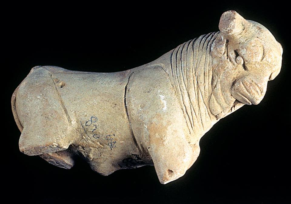
At the historical level, the sudden decline of the Indus civilization around 1900 BC remains a mystery. Historians point to aspects of Minoan civilization (Crete) showing astonishing similarities with the IVC, especially watermanagement and early sewer systems in Knossos, lost wax broze casting techniques and bull fighting.
A few traces of fire and destruction, as well as forty skeletons wounded with knives and found without burial at Morenjo-daro, first suggested an invasion by Aryan peoples from Central Asia or the Iranian plateau. « This theory has now been abandoned. We have indeed found no effective trace of massacres or violence on the sites of the Indus Valley, or furniture that could be associated with such populations, » says Aurore Didier, researcher at the CNRS and director of the Indus mission.
Another hypothesis, an inability to strengthen its resilience to climatic chaos. « The samples taken in the northwest of India have shown that the climate there has changed significantly about 2000 years before our era. It is reported that this was also the case in Mesopotamia. « It became more like the dry and arid climate of today, which disrupted the cultivation and, in fact, the trade of the Indus civilizations. The ensuing socio-economic upheaval may have led to the decline of these societies. This hypothesis is the most commonly accepted to date, » says the archaeologist.
The inhabitants would have left their valleys become infertile to migrate to the plains of the Ganges. « This was accompanied by a change in livelihood strategies. The Indus civilization gradually converted to summer cereal crops based on rice and millet, two commodities more able to withstand these new climatic conditions and requiring, for rice, the development of irrigated agriculture, » says Aurore Didier. « It has also forged links with new trading partners.”
So there is no reason to talk about the « collapse » of a society in the sense of collapsologists. It is rather a gradual adaptation to the evolution of the environment, spread over several centuries.
As the excavations of the sites of the Indus Valley civilization continue, new information will undoubtedly contribute to a better understanding of its history and development. Any additional knowledge of this common civilizational legacy will serve in the future as a basis for fraternal cooperation between Pakistan, India and Afghanistan and others.
In the meantime, instead of trying to copy the barbaric « models » of the Mongolian Empire, the Roman Empire or the British Empire, the « elites » of the transatlantic world would do better to draw inspiration from a magnificent civilization that seems to have prospered for 5,000 years without perpetual wars and massacres, but simply thanks to a good mutual understanding, at the national level, between citizens, and thanks to mutually beneficial cooperation with the overriding majority of its distant partners.
The Indus Valley Civilization’s modernity, capable of offering food, shelter, water and sanitation to all, in a mirror image, shows all of us living in the present, how backwards we became.
Index, Études Renaissance

INDEX, Etudes Renaissance
- FR en ligne — Mohenjo-Daro, Harappa: Le défi que nous lance la modernité de la Civilisation de l’Indus;
- EN online — Mohenjo-Daro, Harappa :The challenging modernity of the Indus Valley Civilization;
- FR en ligne — La Route de la soie maritime, une histoire de 1001 coopérations;
- EN online — The Maritime Silk Road, a History of 1001 cooperations;
- FR en ligne — Cyrus le Grand, l’Iran et le dialogue des civilisations;
- EN online — Cyrus the Great, Iran and the Dialogue of Civilizations;
- FR en ligne — Afghanistan, le pays des 1000 cités d’or et l’histoire d’Aï Khanoum;
- EN online — Afghanistan: the Land of a 1000 Golden Cities and Aï-Khanoun;
- FR en ligne — Le miracle du Gandhara, quand Bouddha s’est fait homme;
- EN online — The miracle of Gandhara: when Buddha turned himself into man;
- FR en ligne — Derrière les chevaux célestes chinois, la science terrestre;
- EN online — The Earthly Science behind China’s Heavenly Horses;
- FR en ligne — Et l’Homme créa l’acier…;
- FR en ligne — Portraits du Fayoum: un regard de l’au-delà (FR en ligne);
- EN pdf online — A Gaze from the Beyond — The Extraordinary Faiyûm Portaits;
- EN AUDIO PARIS: The Greek tradition behind the Fayum Mummy Portraits;
- FR en ligne — La pratique ancestrale d’annulation des dettes;
- EN online — The Ancient Practice of Debt Cancelation;
- RU pdf online — The Ancient Practice of Debt Cancelation (Russian translation) ;
- FR en ligne — Bagdad, Damas, Cordoue, creuset d’une civilisation universelle;
- FR en ligne — Mutazilisme et astronomie arabe, deux étoiles brillantes au firmament de la civilisation;
- EN online — Mutazilism and Astronomy, two brilliant stars at the firmament of civilization;
- FR en ligne — Qanâts perses et Civilisation des eaux cachées;
- EN online — Persian Qanâts and the Civilization of Hidden Waters;
- FR en ligne — Renaissance africaine: la splendeurs des royaumes d’Ifè et du Bénin;
- EN online — The splendors of the kingdoms of Ife and Benin;
- FR en ligne — Sur la peinture chinoise et son influence en Occident;
- EN pdf online — On Chinese painting and its influence on the West (Fidelio);
- FR en ligne — L’invention de la perspective (Magazine Fusion);
- EN pdf online — The Invention of Perspective (Fidelio);
- FR en ligne — La révolution du grec ancien, Platon et la Renaissance;
- EN online — The Greek language project, Plato and the Renaissance;
- FR en ligne — Les Frères de la vie commune et la Renaissance du nord;
- NL online — Moderne Devotie en Broeders van het Gemene Leven, bakermat van het humanisme;
- EN online — Devotio Moderna, Brothers of the Common Life, the cradle of humanism in the North;
- FR en ligne — 1405: l’amiral Zheng et les expéditions maritimes chinoises;
- EN online — Zhang He and the Chinese Maritime Expeditions;
- FR en ligne — Jan van Eyck, la beauté comme prégustation de la sagesse divine;
- EN online — Jan van Eyck, beauty as foretaste of divine wisdom;
- EN AUDIO BERLIN: AUDIO – Van Eyck’s theological metaphor in his Madonna in the Cathedral;
- FR en ligne — Jan Van Eyck, un peintre flamand dans l’optique arabe;
- EN online — Jan Van Eyck, a Flemish Painter using Arab Optics;
- FR pdf en ligne — Rogier Van der Weyden, maître de la compassion;
- EN AUDIO PARIS: Van der Weyden and Cusanus;
- FR en ligne — Comment Jacques Cœur a mis fin à la Guerre de Cent Ans;
- EN online — How Jacques Cœur put an end to the Hundred Years’ War;
- EN AUDIO PARIS: Who whispered in the Ear of Joan of Arc?;
- FR en ligne — Hugo van der Goes et la Dévotion moderne;
- EN pdf online — Hugo van der Goes and the Devotio Moderna;
- FR en ligne — A la découverte d’un tableau;
- EN AUDIO PARIS — Ghirlandaio’s immortality;
- FR en ligne — Avicenne, Ghiberti, leur rôle dans l’invention de la perspective à la Renaissance;
- EN on line — Avicenna, Ghiberti, their role in the invention of perspective at the Renaissance;
- FR en ligne — ENTRETIEN Omar Merzoug: Avicenne ou l’islam des lumières;
- EN pdf online — INTERVIEW Omar Merzoug: New Biography of Ibn Sina;
- FR en ligne — Les secrets du dôme de Florence;
- EN pdf online — The Secrets of the Florentine Dome (Schiller Institute Archives);
- DE pdf online — Die Geheimnisse des Florentiner Domes lüften (Neue Solidarität);
- FR pdf en ligne — Le Dome de Brunelleschi, un défi, un scandale, un exploit (Hors Série Beaux Arts Magazine, 2013)
- EN AUDIO PARIS — Cimabue, Giotto, Fra Angelico; Wonders of the Italian Trecento;
- FR en ligne — L’œuf sans ombre de Piero della Francesca;
- EN pdf online — The Egg Without a Shadow of Piero della Francesca;
- RU pdf online — The Egg Without a Shadow of Piero della Francesca (Russian translation);
- EN AUDIO MILAN — Piero della Francesca at Milan Brera Pinacoteca;
- EN AUDIO PARIS — Antonello de Messina in the Image of Christ;
- FR en ligne — Uccello, Donatello, Verrocchio et l’art du commandement militaire;
- EN online — Uccello, Donatello, Verrocchio and the Art of Military Command;
- EN AUDIO PARIS: Leonardo and Verrochio’s workshop;
- FR en ligne — Le Cénacle de Meaux et l’humanisme chrétien à la Renaissance;
- EN online — The Cenacle of Meaux and Christian Humanism at the Renaissance;
- FR en ligne — La Cène de Léonard, une leçon de métaphysique;
- EN pdf online — Leonardo‘s Last Supper, A lesson of Metaphics (Fidelio);
- EN AUDIO TONGERLO + article online: Leonardo’s copy of The Last Supper in Tongerlo;
- FR en ligne — L’ombre de Vernadski dans la Sainte Anne de Léonard de Vinci;
- EN online — The Shadow of Vernadsky in Leonardo’s Virgin and Child with Saint Anne;
- IT online — L’ombra de Vernadsky nella Santa Anna di Leonardo da Vinci;
- FR en ligne — Léonard de Vinci : peintre de mouvement;
- EN pdf online — Leonardo, painter of movement (Fidelio);
- EN AUDIO PARIS — Mona Lisa made in China?;
- FR en ligne — La Vierge aux rochers, l’erreur fantastique de Léonard;
- FR en ligne — Romorantin et Léonard ou l’invention de la ville moderne;
- EN pdf online — Leonardo da Vinci Imagines the First Modern City (Executive Intelligence Review);
- DE online — Leonardos großes Infrastrukturprojekt für Frankreich (Neue Solidarität);
- IT online — Leonardo da Vinci, Romorantin e lo spirito del progetto NAWAPA (Movisol website);
- FR en ligne — L’Homme de Vitruve de Léonard de Vinci;
- EN online — Leonardo’s « Vitruvian Man »;
- FR en ligne — Léonard en résonance avec la peinture traditionnelle chinoise — entretien en français de Karel Vereycken avec Le Quotidien du Peuple;
- CH online — Leonardo resonates with traditionnal Chinese Painting, interview in Chinese language of Karel Vereycken in People’s Daily;
- EN online — Leonardo resonates with traditionnal chinese painting, interview in English of Karel Vereycken in People’s Daily;
- EN AUDIO PARIS — Why Leonardo didn’t like painting;
- FR pdf en ligne — Raphaël, entre mythe et réalité;
- EN pdf online — Raphael, between Myth and Reality;
- FR en ligne — Raphaël 1520-2020 : ce que nous apprend « L’Ecole d’Athènes »;
- EN online — Raphael 1520-2020: What Humanity can learn from the « School of Athens »;
- EN AUDIO MILAN: Raphael’s cartoon of « The School of Athens »;
- EN online — Jacob Fugger « The Rich », father of financial fascism;
- FR en ligne — Jacob Fugger « Le Riche », père du fascisme financier;
- FR en ligne — Comment la folie d’Erasme sauva notre civilisation;
- EN pdf online — How Erasmus’ Folly saved our Civilization (Schiller Institute Archive Website)
- DE pdf online — Wie Erasmus‘ Torheit unser civilisation rettete (Neue Solidarität);
- NL pdf online — Hoe Erasmus zotheid onze beschaving redde (Agora Erasmus);
- FR en ligne — Le rêve d’Erasme: le Collège des Trois Langues de Louvain;
- EN online — Erasmus‘ dream: the Leuven Three Language College;
- EN AUDIO PARIS — Why Erasmus had no time to pause for portraits;
- FR en ligne — ENTRETIEN: Jan Papy: Erasme, le grec et la Renaissance des sciences;
- FR en ligne — Dirk Martens, l’imprimeur d’Erasme qui diffusa le livre de poche;
- FR en ligne — 1512-2012 : Mercator et Frisius, des cosmographes aux cosmonautes
- NL pdf online — 1512-2012 : Van kosmograaf tot kosmonaut, Mercator en Frisius (Agora Erasmus);
- EN pdf online — 1512-2012: Mercator and Frisius, from cosmographers to cosmonauts (Schiller Institute Archive Website).
- FR en ligne — La nef des fous de Sébastian Brant;
- FR en ligne — Avec Jérôme Bosch sur la trace du Sublime;
- EN pdf online — With Hieronymus Bosch, On the Track of the Sublime;
- EN AUDIO PARIS: How Bosch’s Ship of Fools drove the Jester out of business;
- NL online — Quinten Matsys en Da Vinci: dageraad van louterend gelach en creativiteit;
- FR en ligne — Quinten Matsys et Léonard — L’aube d’une ère du rire et de la créativité;
- EN online — Quinten Matsys and Leonardo — The Dawn of the Age of Laugher and Creativity;
- RU pdf online — Quinten Matsys and Leonardo — The Dawn of the Age of Laughter and Creativity (Russian translation);
- EN AUDIO BERLIN: Matsys and the Art of « The Deal »;
- FR en ligne — Joachim Patinir et l’invention du paysage en peinture;
- EN AUDIO BERLIN: Joachim Patinir and the Homo Viator;
- EN online — Joachim Patinir and the invention of landscape painting;
- FR en ligne — Le Landjuweel d’Anvers de 1561 — Faire de l’art une arme pour la paix;
- EN online — The 1561 Landjuweel of Antwerp that made art a weapon for Peace;
- FR en ligne — Exposition de Lille : ce que nous apprennent les fabuleux paysages flamands;
- FR en ligne — « Le portement de croix » : redécouvrir Bruegel grâce au livre de Michael Gibson;
- EN pdf online — Book review: Michael Gibson on Bruegel’s « Carrying of the Cross. » (Fidelio);
- FR en ligne — ENTRETIEN Michael Gibson: Pour Bruegel, le monde est vaste;
- EN pdf online: INTERVIEW — Michael Gibson: ‘For Bruegel, his world is vast’;
- FR en ligne — Pierre Bruegel l’ancien, Pétrarque et le Triomphe de la Mort;
- EN online — Pieter Bruegel the Elder, Petrarch and the Triomph of Death;
- FR en ligne — A propos du film « Bruegel, le moulin et la croix »;
- FR en ligne — L’ange Bruegel et la chute du cardinal Granvelle (FR en ligne).
- FR en ligne — Pieter Bruegel l’ancien, commentateur politique et pacifist;.
- EN online — Pieter Breugel The Elder, political commentator and pacifist;
- EN AUDIO BERLIN — Bruegel’s Two Apes;
- EN AUDIO ANTWERP — Bruegel’s « Dulle Griet » (Mad Meg): we see her madness, but do we see ours?
- EN AUDIO BRUSSELS — Bruegel’s Theodicy: The Fall of the Rebel Angels.
- EN AUDIO BRUSSELS — Bruegel’s Fall of Empire (Icarus)
- EN AUDIO BRUSSELS — What Bruegel’s snow landscape teaches us about human fragility;
- EN AUDIO BERLIN — The Culture behind Brueghel’s Proverbs;
- FR en ligne — Albrecht Dürer contre la mélancolie néo-platonicienne
- EN pdf online — Albrecht Dürer’s fight against neo-Platonic Melancholy;
- EN pdf online — How neo-Platonism gave Plato a bad name;
- EN online — Shakespeare‘s lesson in economics;
- FR en ligne — La leçon d’économie de Shakespeare;
- RU pdf online — Shakespeare’s lesson in economics (Russian translation);
- FR en ligne — Le combat inspirant d’Henri IV et de Sully;
- EN pdf online — The Inspiring Example of Henri IV and Sully (Schiller Institute Archives Website);
- FR en ligne — La paix de Westphalie, une réorganisation financière mondiale
- EN online — The Peace of Westphalia, a worldwide Financial Reorganisation;
- FR pdf en ligne — Rembrandt, un bâtisseur de nations (Nouvelle Solidarité).
- FR en ligne — Rembrandt et la lumière d’Agapè;
- EN online — Rembrandt and the Light of Agapè;
- FR en ligne — Rembrandt : 400 ans et toujours jeune!;
- EN online — Rembrandt: 400 years old and still young!;
- FR en ligne — Rembrandt et la figure du Christ;
- EN pdf online — Rembrandt and the Face of Jesus;
- DE online — Rembrandt and das Gesicht Jesu;
- FR en ligne — Le portrait d’Anslo de Rembrandt, la science de « peindre l’invisible »;
- EN online — Rembrandt’s Anslo, the science of « painting the invisible »;
- RU online — Rembrandt’s Anslo, the science of « painting the invisible » (Russian translation);
- EN AUDIO BERLIN: Rembrandt painting the voice of Anslo;
- FR pdf en ligne — Metsu, Ter Borch, Hals, l’éloge du quotidien;
- EN AUDIO PARIS — Why Vermeer was hiding his convictions;
- EN AUDIO BERLIN — Vermeer’s Young Woman with a Pearl Necklace;
- FR en ligne — Entre l’Europe et la Chine: le rôle du jésuite flamand Ferdinand Verbiest;.
- FR en ligne — Avec Leibniz et Kondiaronk, re-créer un monde sans oligarchie;
- EN online — With Leibniz and Kondiaronk, re-inventing a world without oligarchy;
- FR en ligne — Francisco Goya et la révolution américaine (FR en ligne)
- EN pdf online — Francisco Goya and the American Revolution (Fidelio)
- ES pdf online — Francisco Goya y la revolucion Americano (Fidelio);
- EN AUDIO BRUSSELS — Goya asks us to make sure Truth raises again;
- EN AUDIO BRUSSELS — Goya’s Simpleton not simple;
- EN AUDIO BRUSSELS — Goya’s portrait of Bayeu;
- ES BOOK — Karel Vereycken et Karl Lestar : El Degüello de Goya;
- FR en ligne — Beethoven et le Meeresstille: initiation à une culture de la découverte
- EN pdf online — Beethoven’s Meeresstille: initiation into a culture of discovery (Schiller Institute Archive Website);
- DE pdf online — Beethovens Meeresstille: Reise in eine Kultur des Entdeckens (Neue Solidarität);
- FR en ligne — Enseignement mutuel: curiosité historique ou piste d’avenir?;
- EN online — Mutual Tuition: historical curiosity or promise for a better future?;
- FR en ligne — Le combat républicain de David d’Angers, la statue de Gutenberg à Strasbourg;
- EN online — The republican struggle of David d’Angers and the Gutenberg statue in Strasbourg;
- FR en ligne — Hippolyte Carnot, père de l’éducation républicaine moderne;
- EN online — Hippolyte Carnot, father of modern republican education;
- FR en ligne — Victor Hugo et le colosse;
- EN online — Victor Hugo and the awakening of the colossus;
- FR en ligne — Avec le peintre James Ensor, arrachons le masque de l’oligarchie ;
- EN online — How James Ensor ripped off the mask of the oligarchy;
- FR en ligne — Enquête sur les origines de l’art moderne, la question du symbolisme;
- EN online — On the Origins of Modern Art, the Question of Symbolism;
- FR en ligne — Les racines symbolistes des killer games:
- EN online — Neo-Platonism and Huxley’s Doors of Perception;
- FR en ligne — L’art moderne de la CIA pour combattre le communisme;
- EN online — The Congress for Cultural Freedom (CCF) – How the CIA « weaponized » Modern Art;
- FR pdf en ligne — M. Hockney, le génie artistique n’est pas une illusion optique ! (Fusion);
- DE pdf online — Herr Hockney ! Kunst is keine rein technische fertigheit (Neue Solidarität);
- EN pdf online — Mr Hockney! Great Art Requires More Than Optcal Technology (21st Science & Technology).
- FR en ligne — Gérard Garouste et La Source (FR en ligne).
- EN online — Rembrandt’s oil painting is back… in China !
- FR en ligne — Ce que nous apprend l’expérience Trou-dans-le-Mur de Sugata Mitra;
- EN online — The hidden lesson behing Sugata Mitra‘s Hole-in-the-Wall experience;
- FR en ligne — La défense du patrimoine culturel de l’Humanité, clé d’une paix mondiale;
- EN online — Empathy, Sympathy, Compassion: Cultural Heritage Key to World Peace
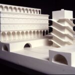
Romorantin et Léonard ou l’invention de la ville moderne

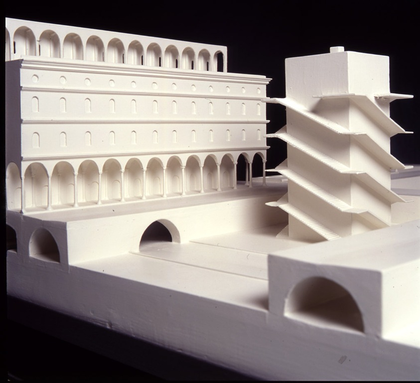
Romorantin, une ville entièrement construit sur l’eau. Maquette élaborée à partir des dessins de Léonard de Vinci.
English version of this article: romorantin EN
German version: romorantin DE
Italian version: Leonardo da Vinci Romorantin e lo spirito del progetto NAWAPA
Par Karel Vereycken, 2010.
En automne 1516, Léonard de Vinci, ingénieur génial et spécialiste de la gestion de l’eau, est appelé d’urgence en France. Il accepte alors une offre très spéciale formulée par François 1er et souhaitée par sa sœur Marguerite de Navarre, protectrice de François Rabelais et d’autres membres du mouvement de jeunes d’Erasme.
Il s’agit de faire de Romorantin, centre urbain plus que modeste à l’époque, la nouvelle capitale française, pivot et levier d’un grand dessein national de développement économique. La Cour, à l’époque basée à Tours où elle manque de place et d’espace pour s’étendre, y viendrait s’installer.
La pensée urbanistique dynamique de Léonard, qui a pris forme lors de son second séjour milanais, conçoit la ville en termes de flux d’eau, d’air, d’énergie et de créativité humaine. Il ne s’agit pas d’une « Città ideale » statique, mais d’un centre de vie, de culture et de production agro-industrielle.
Comme preuve, la construction de huit nouveaux moulins (à foulons ?) est planifiée en périphérie, le long de la rivière locale dont on prévoit d’augmenter le débit afin d’accroître la puissance des moulins.
D’ailleurs, sur le feuillet 785b de son Codex Atlanticus, Léonard présente une liste d’industries pouvant fonctionner grâce à la force motrice de l’eau :
Scieries, machines à fouler, papeteries, forges, coutelleries, bronzage d’armes, manufactures de poudre et de salpêtre, filatures de soie employant cent femmes, tissages de rubans, tourneries de vases fins et jaspe et porphyre.
Aussi, entre Romorantin et Amboise, un grand projet d’assèchement des marais de la région de la Loire prévoit la création de bonnes terres agricoles.
Léonard ne se contente donc nullement de l’idée d’y ériger un splendide palais conjuguant goût français et prouesses de la Renaissance italienne, mais envisage de fonder une ville révolutionnaire, entièrement construite sur l’eau !
Pourvue de canaux de transport fluvial, Léonard envisage de séparer les eaux propres des eaux usées via un système du tout-à-l’égout. Il invente aussi des étables de chevaux « automatiques ».
-
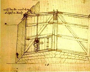
Dessin de Léonard. Une écurie équipée d’un mécanisme automatique permettant de nourrir les chevaux avec le foin stocké à l’étage.
Les épidémies, qui faisaient à l’époque des ravages en milieu urbain, pourront être contenues grâce à une gestion intelligente des eaux.
Comme Léonard l’écrit dans le Codex Atlanticus (65 v-b), il faut éviter à tout prix « une aussi considérable agglomération de gens, parqués comme des chèvres en troupeau, l’une sur le dos de l’autre, qui emplissent tous les coins de leur puanteur et sèment la pestilence et la mort »
-
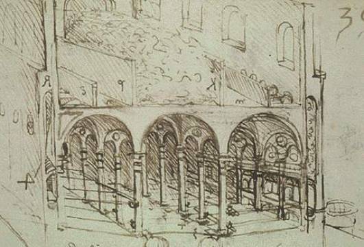
Dessin de Léonard d’une porte d’écluse équipée de « portes busquées » et ventiles.
Pour lancer le projet, il fallait en premier lieu relier cette nouvelle capitale, située sur la Sauldre (un sous-affluent de la Loire), à la Loire, la plus longue route commerciale de France, ouverte sur l’Atlantique, grâce à une série de canaux équipés d’écluses ultramodernes à « portes busquées » et ventiles.
Ainsi, en janvier 1518, François 1er allouera « 4000 livres d’or pour faire la rivière de la Sauldre navigable depuis Romorantin jusqu’au lieu où elle tombe en la rivière du Cher », l’affluent navigable de la Loire.
Du fait que Léonard élabore à la même époque les plans pour la construction du Havre de grâce [le port du Havre] en Normandie, on estime qu’il s’agissait d’un dessein national visant à donner au centre de la France la dimension d’une région à forte activité économique digne d’accueillir la Cour.
Ce que l’on sait, c’est que Léonard étudie les possibles liaisons fluviales capables de désenclaver Romorantin, et au-delà, la France – peut-être celle reliant Romorantin à la Seine, via la Loire, réalisée seulement en 1604 par Sully, mais certainement celle de la Loire avec le couloir Saône-Rhône, via un canal dont Léonard envisageait la construction (l’actuel canal du Centre), permettant d’ouvrir sur la Méditerranée l’ensemble de ce grand corridor de développement économique.
-
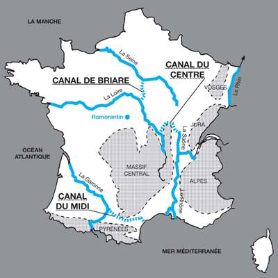
Projets des canaux de jonction qui restaient à réaliser à la Renaissance: 1) Le canal du Midi reliant la Méditerranée avec l’Océan atlantique; 2) Le canal de Briare, reliant la Loire avec la Seine; 3) Le canal du centre reliant la Saône avec la Loire.
En bref, le plan de Léonard envisageait de réaliser un vaste corridor de développement économique reliant la Méditerranée à l’Atlantique, permettant de désenclaver l’intérieur du continent.
Carlo Pedretti, le grand expert italien de Léonard de Vinci et de la Renaissance et auteur d’un livre sur Romorantin en 1972, déclara en 2009 que le projet royal pour Romorantin était parfaitement comparable au « projet de la Tennessee Valley Authority [TVA : grand projet d’aménagement fluvial qui tira les Etats-Unis de la dépression] de Franklin Delano Roosevelt ».
Le chantier, pourtant bien commencé, fut abandonné. A cause de la peste selon les uns, faute d’argent selon les autres.
Surtout, Léonard, qui arrive à la fin de sa vie, n’a plus la force de diriger une opération d’une telle envergure et personne n’émerge pour prendre le relais. François 1er opte pour une autre Renaissance, celle des apparences.
Dès la mort de Léonard en 1519, il lance la construction d’un énorme projet de prestige, le château de Chambord, le plus vaste des châteaux de la Loire. Pourtant, il ne s’agit que d’un simple rendez-vous de chasse.
Le projet pour Romorantin sera enterré avec Léonard !
Signalons que depuis le 9 juin 2010, une belle exposition a été présentée au musée de Sologne de Romorantin-Lathenay présentant ce projet oublié de Léonard de Vinci. Nos dirigeants pourraient y apprendre plein de choses !