Étiquette : British Museum
The challenging modernity of the Indus Valley Civilization

Get an easy-to-print pdf file of this article
Karel Vereycken, Paris, France, January 2023
A major archaeological discovery has just been made in Israel in 2022: the first evidence of the use of cotton fibers in the Near East and among the oldest in the world, dating back nearly 7,000 years, was discovered by Israeli, American and German archaeologists during an archaeological excavation at Tel Tsaf, southeast of Beit She'an, in the Jordan Valley of Israel.

So far, the earliest available evidence of cotton fibers in the area was dated to a few hundred years later, to the late Chalcolithic (Copper Age) and Early Bronze Age (about 5,000 to 6,500 BCE) from the archaeological site of Dhuweila in eastern Jordan.
Discovered in 1940, the site of Tel Tsaf reveals its secrets. « Tsaf is characterized by an amazing preservation of organic materials, » said Professor Danny Rosenberg of the Zinman Institute of Archaeology at the University of Haifa. « Tel Tsaf was a kind of pole that concentrated important commercial activities and had established contacts with many other peoples, » Rosenberg believes. « There was massive storage capacity there to accommodate grain, enormous capacity if you compare it to other sites.
For example, the earliest evidence of the social use of beer drinking and ritual food storage has been found there. Rosenberg and the other researchers also found beads from contemporary Anatolia, Romania, Egypt and other parts of Africa; pottery from Iraq, Syria and Armenia; and the earliest copper and other metals found in the world.
“Wool Tree” and “Cotton Roads”
The cotton found in Israel, probably came from the Indus region—modern Pakistan/India—which was the only place in the world that had begun to domesticate cotton at that time before its cultivation appeared in Africa thousands of years later.
« What’s interesting about this early evidence of a link to such a distant region is that it comes from fibers – microscopic pieces of ancient yarn. We assume that these cotton fibers, found along with wool fibers and plant fibers, arrived at the site as part of fabrics or clothing, i.e., ancient textiles, » Rosenberg says.
In addition, cotton was not only used for clothing: « In the prehistoric era, textiles were involved in many areas of life, not only in clothing but also in hunting, fishing … This is much more important than just saying that what we found are pieces of clothing that were worn by the inhabitants of the area. This discovery tells us a lot about the economic practices of the area, » says Rosenberg.
Since cotton had never been grown in Tel Tsaf, it was a surprise for the researchers to find it, and they felt that its presence underscored the city’s importance as a global trading hub at the heart of what could be called, the « Cotton Roads » of those days.
Growing cotton poses major challenges: a moderate to tropical climate and vast amounts of water. Just to produce a single T-shirt and a pair of jeans (representing about 1 kg of cotton), no less than 20,000 liters of water are required! Which civilization can afford such a performance at the beginning of the 7th millennium BC?
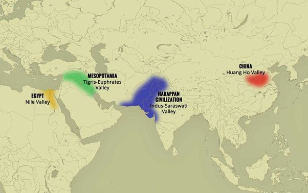
The Indus Valley civilization (IVC)
The term « Indus Valley Civilization » (IVC) refers to a vast cultural and political entity that flourished in the northern region of the Indian subcontinent between about 8000 and about 1900 BCE., a region that stretched from Baluchistan (Pakistan) in the west to Uttar Pradesh (India) in the east and from northeastern Afghanistan in the north to Gujarat (India) in the south.
In the absence of both literary sources and remnants of palaces and temples to confirm it, one cannot qualify this entity as a “Kingdom” or an “Empire”. Its modern name (IVC) derives simply from its location in the Indus Valley, but also goes under the name of the « Indus-Sarasvati civilization » or « Harappan civilization ». These last designations come from the river Sarasvati, mentioned in the Vedic sources, which flowed next to the Indus and which would have disappeared, and from the ancient city of Harappa (Punjab, Pakistan), discovered by the British in 1829, but deliberately left unexplored.
The rise of a great urban civilization in the Indus Valley, which reached its maturity around 2500-2400 BCE, was long considered a sudden and mysterious phenomenon. Today, a series of discoveries allows us to follow, from 7000 to 2500 BCE, a series of transformations and innovations whose cumulative effects, stimulated by the enlargement of the network of exchanges from 3000 BCE onwards, created the conditions for the development of an incredibly modern and prosperous urban civilization.
Enter Mehrgarh, the light of the world!
Since prehistoric times, the Indus region has been pioneering and rich in discoveries. As an example, for the Guinness Book of Records, although a case apart, the farming village of Mehrgarh (Baluchistan, Pakistan) which dates from the Neolithic (using only stones as tools) but can be considered as the key culture and city that lead humanity, as early as in the 8th millennia BCE, from the Stone Age into the Age of Copper.
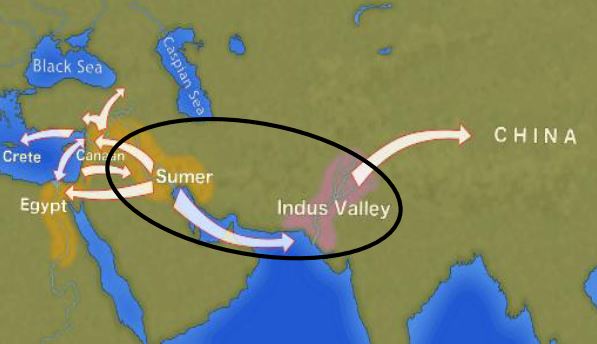
The site is located on the principal route between what is now Afghanistan and the Indus Valley: this route was also undoubtedly part of a trading connection established quite early between the Near East and the Indian subcontinent.
Excavations in Mes Aynak (Afghanistan), where archaeologists are only beginning to find remnants of a 5,000-year-old Bronze Age site beneath the Buddhist level, including an ancient copper smelter, will undoubtedly shed new light on these relationships.
On the basis of a variety of well-documented archaeological finds, it has been established that “pre-Harrapan” Mehrgarh, made several historical breakthroughs for the benefit of humanity as a whole.
Mehrgarh gave the world:
- among the oldest traces of agriculture (wheat and barley) and breeding (cattle, sheep and goats) in South Asia ;
- the first breweries (with wheat and barley);
- the oldest reservoirs for irrigated agriculture and flood prevention;
- the oldest traces of cotton culture (6th millennium BCE);
- the oldest jewel, called the « Mehrgarh amulet » (6th millennium BCE), produced with the « lost wax » bronze casting technique ;
- the oldest bow drills (in green jasper) allowing to drill holes in lapis lazuli and carnelian;
- the very first traces of successfull dentistry practices (!) (9th millennium BCE); The inhabitants of Mehrgarh appeared to have developed an understanding of surgery and dentistry, as evidenced by the drilled teeth of some of the skeletons found at the site. Analysis of the teeth shows that prehistoric dentists worked to treat toothaches with drills made from flint heads. The work was so elaborate that even modern dentists are surprised at the efficiency with which the Mehrgarh « dentists » removed decaying tooth tissue. Among the remains, a total of eleven drilled crowns were found, with one example showing evidence of a complex procedure involving the removal of tooth enamel followed by carving of the cavity wall. Four of the teeth show evidence of decay associated with the drilled hole. None of the individuals with drilled teeth appear to have come from a special tomb or shrine, indicating that the oral health care they received was available to all.

Densely populated
Originally, the IVC was built around the fishy meanders of the Indus, a river nearly 3200 kilometers long that flows from the Himalayan mountains towards the Arabian Sea. Like the populations of other great river valleys, this society was seduced by the fertility of the land as well as by the possibility of using the Indus as a transportation route.
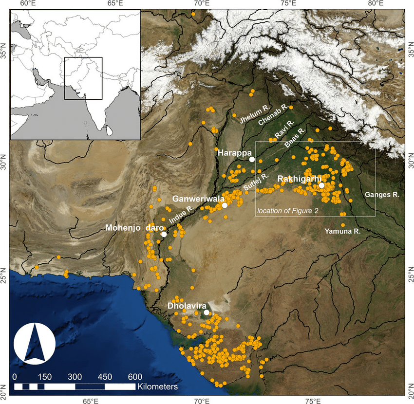
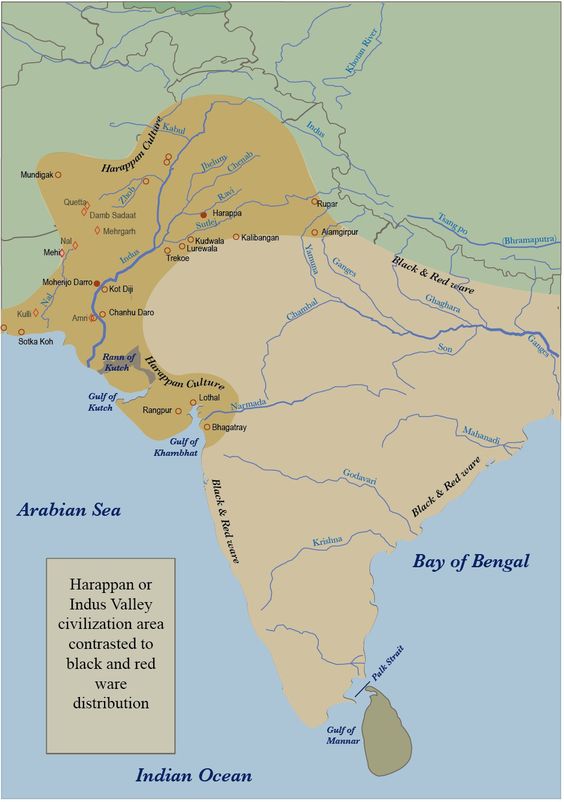
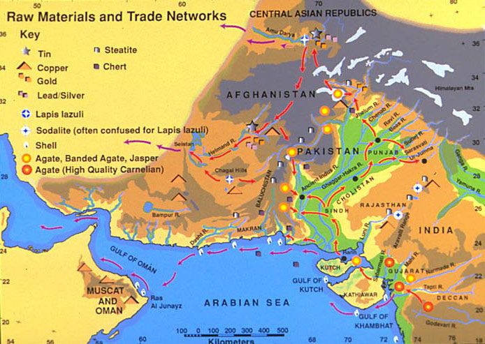
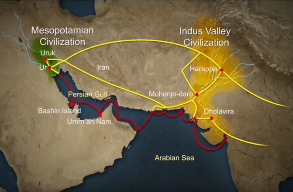
The IVC, whose prosperity rests largely on the increasingly systematic exploitation of the rich silt of the Indus, spread over an immense territory encompassing the entire Indus Valley and part of Indian Gujarat. It is necessary to add to the vast zone of distribution of the Indus civilization some Harappan « colonies » or outposts like Sutkagan Dor (Ballochistan, Pakistan), close to Gwadar on the edges of the sea of Oman, at the Iranian-Pakistani border, and the lapus lazuli mining town of Shortugai, close to Amu Darya river, at the Afghan-Tajik border, at nearly 1,200 kilometers of Mohenjo-daro, by far the largest IVC urban concentration.
At its peak, this civilization was twice as large as the Old Kingdom of Egypt. With an area of 2.5 million square kilometers, it was at the time the largest civilization in the world: it included 5 million people, or 10 % of the world population at the time, much more than less older civilizations as Sumer (0.8 to 1.5 million people) or ancient Egypt (2 to 3 million).
To date, about 2,000 sites have been discovered in India, Pakistan and Afghanistan. Because of various wars and conflicts, only 10 % of the territory of these sites has been excavated and scientifically investigated. On the Indian subcontinent, the main centers of this civilization are Harappa (estimated 23,500 inhabitants) and Mohenjo-daro (est. 40,000 inhabitants) in Pakistan and Lothal, Dholavira and Kalibangan in India. In addition to trade relations with Mesopotamia and Iran, the Harappan city-states also maintained active trade relations with the peoples of Central Asia.
Agriculture, crafts and industry
Agriculture, animal husbandry, industry, trade and commerce were the main source of income.
Agriculture was the main occupation of the people of the Indus Valley. They cultivated barley and wheat on a large scale (and made beer) but also other crops such as legumes, cotton, cereals, sesame, dates, mustard, melons, peas, etc.
There is no real evidence of rice, but a few grains of rice have been found in Rangpur and Lothal.
In the towns of Mehrgarh, Harappa, and Mohenjo-daro, there are remains of large granaries, suggesting that they produced more than they needed and physically stocked cereals and other food products in case of crop failure.
Animal husbandry was another major occupation. Seals suggest that they domesticated cows, buffalos, goats, sheep, pigs, etc. Camels and bullocks were also domesticated and used as beasts of burden. Camel bones have been found in large numbers at many sites, but there is no trace of them on the seals. During the excavation of Surkotado in Gujarat, India, the jawbone of a horse was found. Terracotta figurines representing a horse were found in Nausharo and Lothal.
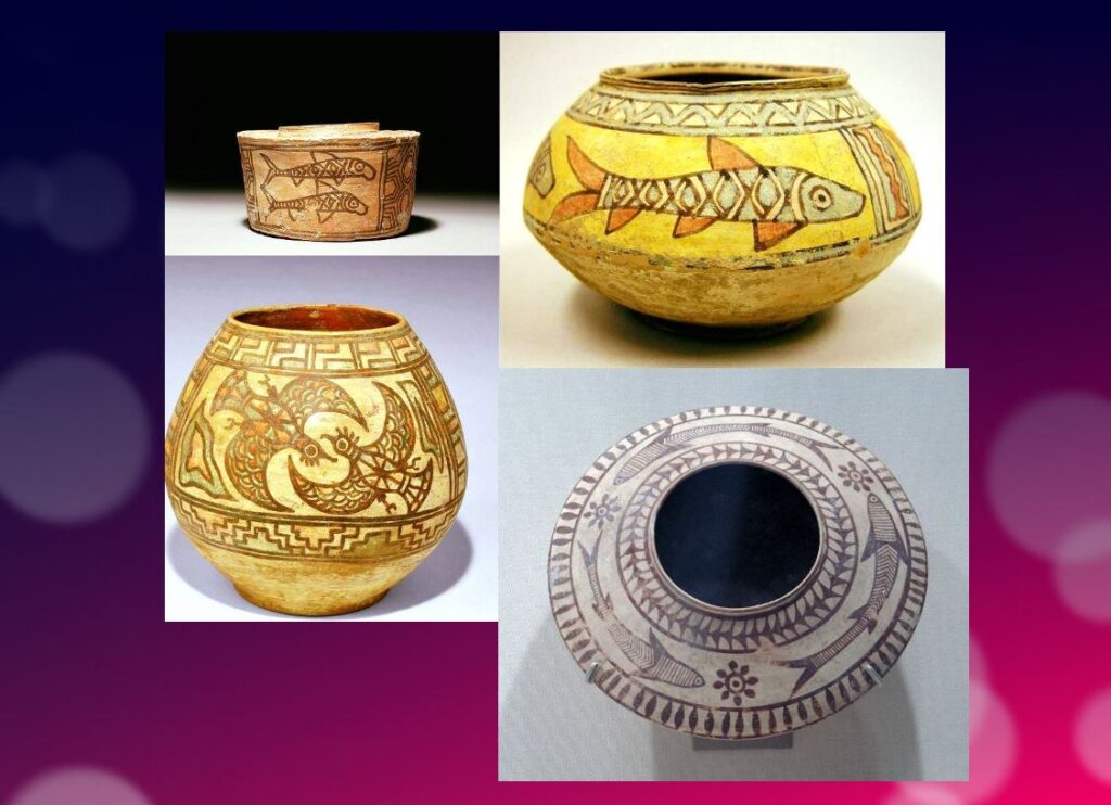
The inhabitants of the Indus Valley were very skillful. They made ceramics, metal vessels, tools and weapons, weaved and spun, dyed and practiced other crafts with potter’s wheels. The weavers wore clothes made of cotton and wool. They knew leather, but there is no record of silk production.
The inhabitants of this civilization originally came from the Bronze Age and used stone tools, but they soon excelled in the manufacture and processing of gold, silver, copper, lead and bronze, especially for artistic ornaments of great finesse.
Artisans made jewelry in Mohenjo-daro, Chanho-daro and Lothal. They used ivory and various precious stones such as carnelian, lapis lazulite, agate and jasper to make them. Shell work was also a thriving industry. Craftsmen in the coastal colonies used shells to make buttons for shirts, pendants, rings, bracelets, beads, etc.
To supply the production of these craft professions, they needed to import various raw materials. To produce bricks and ceramics, clay was available locally, but for metal they had to acquire it from abroad. Trade focused on importing raw materials to be used in Harappan city workshops, including minerals from Iran and Afghanistan, lead and copper from other parts of India, jade from China, and cedar wood floated down rivers from the Himalayas and Kashmir. Other trade goods included terracotta pots, gold, silver, metals, beads, flints for making tools, seashells, pearls, and colored gemstones, such as lapis lazuli and turquoise.
Ox carts were used to transport goods from one place to another. They also constructed barges used on the waterways along the Indus and its tributaries for transportation.
One of the ways historians know about the maritime trade network operating between the Harappan and Mesopotamian civilizations is the discovery of Harappan seals and jewelry at archaeological sites in regions of Mesopotamia, which includes most of modern-day Iraq, Kuwait, and parts of Syria. Long-distance sea trade over bodies of water—such as the Arabian Sea, Red Sea and the Persian Gulf—may have become feasible with the development of plank watercraft that were each equipped with a single central mast supporting a sail of woven rushes or cloth.
Historians have also made inferences about networks of exchange based on similarities between artifacts across civilizations.
Between 4300 and 3200 BCE, ceramics from the Indus Valley Civilization area show similarities with southern Turkmenistan and northern Iran. During the Early Harappan period—about 3200 to 2600 BCE—there are cultural similarities in pottery, seals, figurines, and ornaments that document caravan trade with Central Asia and the Iranian plateau.
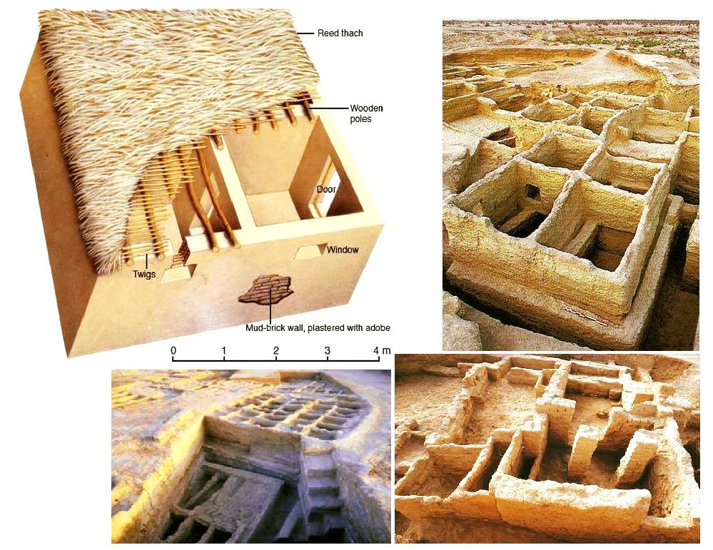
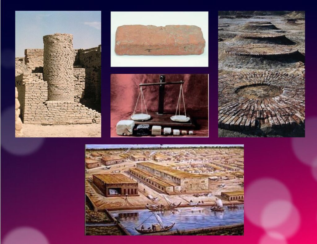
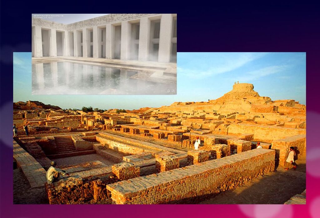
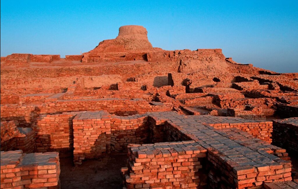
The wonders of Mohenjo-daro
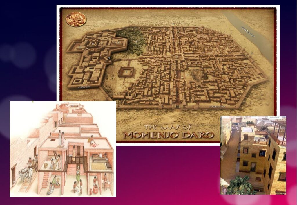
Sometimes referred to as the « Manhattan of the Bronze Age » for the grid pattern of the city plan, Mohenjo-daro (Sind, Pakistan) remained buried under meters of alluvial sediment until 1922.
A real metropolis made of baked bricks, it covers more than 200 hectares. Strictly squared, cut in two by a street of ten meters wide, divided from north to south by a dozen arteries drawn with the cord, and crossed from east to west by paved streets, Mohenjo-daro represents, by its strictly reflected urban framework, the model city of the Indus civilization. It could have accommodated up to 40,000 people!
The Harappans were masters of hydraulic engineering, a “riparian” people working in river corridors practicing irrigated agriculture. They mastered both the shaduf (an irrigation tool used to draw water from a well), and windmills.
In the Harappan cities, the domestic and manufacturing areas were separated from each other.
The inhabitants, living in one-, two-, and sometimes three-story dwellings, seem to have been mainly artisans, farmers, and merchants. The people had developed the wheel, cattle-drawn carts, flat-bottomed boats large enough to carry goods, and perhaps also sailing. In the field of agriculture, they had understood and used irrigation techniques and canals, various agricultural implements, and had established different areas for livestock grazing and cultivation.
Seals and harrapan script
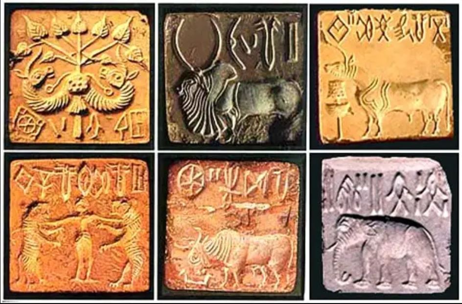
Among the thousands of artifacts found at the various sites are small soapstone seals just over one inch (3 cm) in diameter, used to sign contracts, authorize land sales, and authenticate the point of origin, shipment, and receipt of goods in long-distance trade. On each seal is a small text in Harappan, a language yet to be deciphered.
Among the thousands of artifacts found at the various sites are small soapstone seals just over one inch (3 cm) in diameter, used to sign contracts, authorize land sales, and authenticate the point of origin, shipment, and receipt of goods in long-distance trade.
Commercial contacts between the Indus and Sumer populations are well documented. Numerous seals from the Indus Valley have been discovered in Mesopotamia. On each seal, a small text in Harappean, a language that remains to be deciphered.
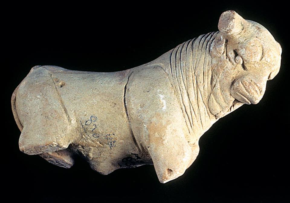
If 4,200 texts reached us, 60 % of them are seals or mini-tablets of stone or copper, engraved, and they comprise on average… only five signs! The longest text has 26 signs. The texts are always accompanied by the image of an animal, often a unicorn or a majestic buffalo. They were intended to mark goods, probably indicating the name of the owner or the recipient and a quantity or a year. Trying to decipher the Indus language is a bit like trying to learn French only from the labels on the food shelf of a supermarket!
The invention of sanitation
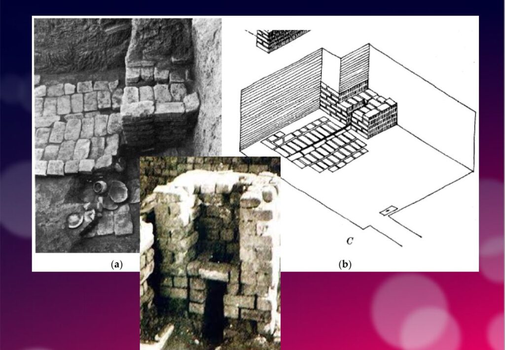
In addition to this particular attention that they paid to urban planning, the members of the Indus civilization also seem to have been pioneers of modern hygiene. Some cities, notably Mohenjo-daro, were equipped with small containers (dustbins) in which the inhabitants could deposit their household waste.
Anticipating our « all to the sewer » systems imagined in the 16th century by Leonardo da Vinci for the project envisaged by François I for the new French capital Romarantin, many cities had already public water supply and an ingenious sanitation system.
In many cities, including Mohenjo-daro, Harappa, Lothal and Rakhigari, individual houses or groups of houses were supplied with water from wells. This quality fresh water was used as much for food and personal hygiene (baths, toilets) as for the economic activities of the inhabitants.
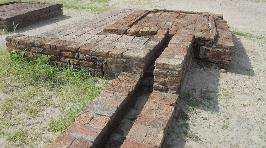
As an example, the sanitation system of the port city of Lothal (Gujarat, India) where many houses had a bathroom and private brick latrines. The wastewater was evacuated through a communal sewer system that led either to a canal in the port, or to a soaking pit outside the city walls, or to buried urns equipped with a hole allowing the evacuation of liquids, which were regularly emptied and cleaned.
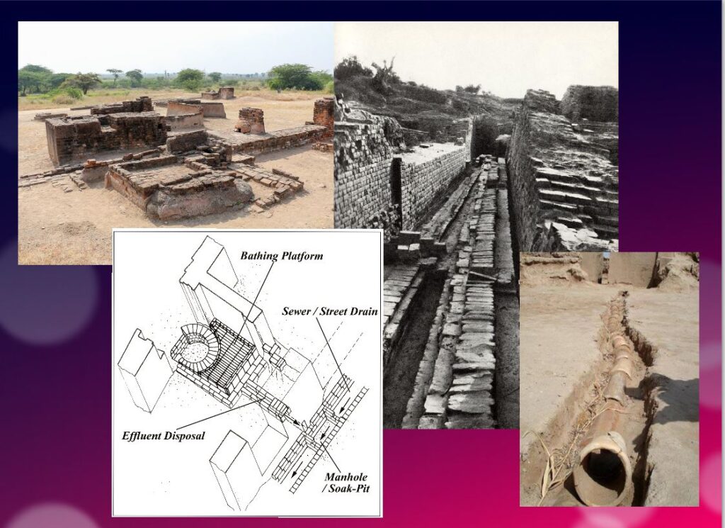
Excavations at the Mohenjo-daro site have also revealed the existence of no less than 700 brick water wells, houses equipped with bathrooms and individual and collective latrines. Toilets were an essential element. However, early archaeologists erroneously identified most toilets as post-cremation burial urns or simple cesspools. Many buildings in the city were two or more stories high. Water from the roof and bathrooms of the upper floors was channeled through closed clay pipes or open troughs that emptied, if necessary via the toilets, into the covered sewers underneath the paved street.
This extraordinary achievement is confirmed by a 2016 scientific study, entitled « The Evolution of Toilets Around the World Across the Millennia, » which reports that,
The earliest multi-flush toilets connected to a sophisticated sewage system that have been identified so far were found in the ancient cities of Harappa and Mohenjo-Daro in the Indus Valley, dating from the middle of the third millennium BC. Nearly every dwelling unit in Harappa, Mohenjo-Daro, and Lothal was equipped with a private bath-toilet area with drains to carry dirty water into a larger drain that emptied into the sewer and drainage system.
Till now, it are the Minoan (Crete) civilization and China that have been credited for the first use of underground clay pipes for sanitation and water supply. In the Cretan capital Knossos, there was a well-organized water system to bring in clean water, to evacuate wastewater and to provide storm sewers for overflow in case of heavy rains.
In Knossos existed also one of the earliest uses of flush toilets, dating back to the 18th century BCE. The Minoan civilization had stone sewers that were periodically cleaned with clean water. Crete, of course, was a large provider of Copper ore for the entire world in Antiquity and had vast international trade connections.
Religious and cultural worldview
In the IVC, fertility rituals were probably observed in order to promote a full harvest as well as for women’s pregnancies, as evidenced by a number of figurines, amulets and statuettes with female form.
It is thought that the people, like the Dravidians who some believe were the origin of the Indus Civilization, worshiped a “mother goddess” and possibly a male companion represented as a horned figure in the company of wild animals.
The « Great Bath » at Mohenjo-daro would have been used for purification rites related to religious belief, but it could just as easily have been a public pool for recreation. Our knowledge of the religious beliefs of this culture remains in the realm of mere hypothesis.
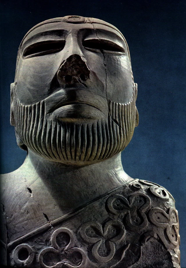
The title of the famous statue of the « Priest-King » found at Mohenjo-daro is misleading, as there is no evidence that it is a king or a priest, and it may be a simple cotton trader…
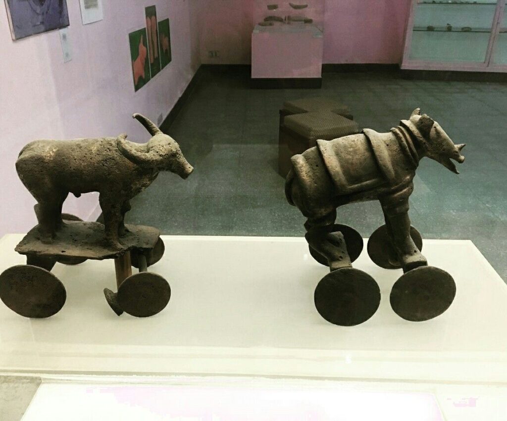
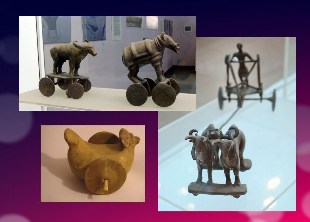
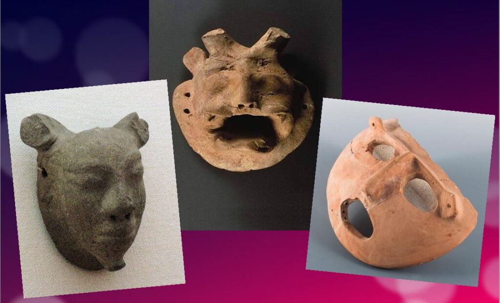
Apart from pottery, certain types of elementary weapons (spearheads, axes, arrows, etc.) and certain tools for practical purposes, two types of artifacts give us cultural clues about Harappean society.
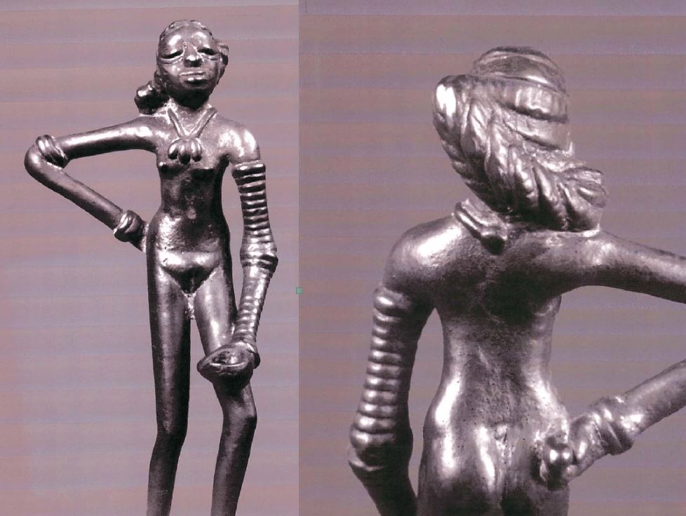
First, some figurines, which we try to interpret as devotional objects, seem to be simple toys. For others, they are clearly toys, notably animals (oxen, buffaloes, elephants, goats and even a simple hen), made of bronze or terracotta, mounted on small carts with wheels.
Second, among other objects expressing a high level of sensitivity and consciousness, a series of masks, some of which seem inspired by Mongolian masks.
These masks are clearly intended to serve comic or tragic representations and remind us of the ancient masks that have come down to us from classical Greece.
Older than Sumer and Egypt?
Archaeological excavations of the IVC got off to a late start, and it is now believed that some of the achievements and « firsts » attributed to Egypt ( – 3150 BC) and Mesopotamia ( – 4500 BC) may in fact belong to the inhabitants of the Indus Valley civilization.
In May 2016, the report published by a team of researchers from IIT Kharagpur, Institute of Archaeology, Deccan College Pune, Physical Research Laboratory and Archaeological survey of India (ASI), published by the journal Nature, shattered a number of “facts” that were considered unshakeable certainties.
Until now, the 900 years of the « mature » phase of the IVC was dated as ranging from 2800 to 1900 BCE. However, the aforementioned Indian study indicates that this civilization was much older than previously thought – it is at least 8,000 years old!
To determine the age of this civilization, researchers dated pottery using a technique called optically stimulated luminescence (OSL) – and found it to be nearly 6,000 years old, the oldest pottery known to date.
Other artifacts have been dated to 8,000 years ago. The results come from a major site excavated at Bhirrana (Haryana, India) that shows the preservation of all cultural levels of this ancient civilization, from the pre-Harappan phase through the Early Harappan to the Mature Harappan period. Bhirrana was part of a high concentration of sites along the mythical Vedic river « Saraswati », now dried up, an extension of the Harki-Ghaggar River in the Thar Desert.
The submerged cities of the Gulf of Khambhat
These new dates converge with the discovery, in January 2002, of ruins of submerged cities in the Gulf of Khambhat (formerly Cambay), off the coast of the state of Gujarat in northwest India.
It is the oceanographers of the National Institute of Ocean Technology (NIOT) of Madras who made this discovery. The team was surveying the muddy sea 30 km off the coast of the state of Gujarat, in the Gulf of Khambhat, to measure the levels of marine pollution. As a routine measure, they recorded acoustic images of the ocean floor.

It was only several months later, while analyzing the data, that the team realized that they had, without knowing it, obtained images of the ruins of a huge city, sunken 40 meters below sea level. And, at the end of January 2002, after having spent weeks to dredge the site and to bring up more than 2 000 objects, the team of the NIOT was able to make extraordinary revelations.
The ruins stretch for 9 km along the banks of an ancient river, and the remains of a dam can be distinguished. The sunken city shares striking similarities with the sites of the Indus civilization. One of the buildings, the size of an Olympic swimming pool, with collapsed steps, recalls the Great Bath of Mohenjo-daro. Another rectangular monument, 200 m long and 45 m wide, is as large as the acropolis discovered at Harappa. The team of NIOT also glimpsed another building, a kind of granary, made of mud bricks, 183 m long. Near these monumental installations, rows of rectangular buildings that resemble the foundations of ruined houses can be seen, and even a drainage system and roads. On another visit to the site, the team recovered polished stone tools, ornaments and figurines, pottery debris, semi-precious stones, ivory and the fossilized remains of a human spine, jaw and tooth. But the team was not at the end of its surprises.
It sent samples of a fossilized log to two major Indian laboratories specializing in dating methods: the Birbal Sbahni Institute of Paleobotany (BSIP) in Lucknow and the National Geophysical Research Institute (NGRI) in Hyderabad. The BSIP dated it to 5500 BCE, while the NGRI dated the sample much earlier, probably to 7500 BCE.
This dating would make Khambhat the oldest site discovered in India. According to some, this discovery could mark the end of the theory according to which urbanization spreads from Asia from the west towards the Indus. This dating caused intense controversy. Archaeologist G. Possehl points out that there is no reason to believe that the fossilized piece of wood belongs to the ruins of the ancient city, given the strong sea currents in the region, it could have come from elsewhere. NIOT’s team acknowledged the validity of these criticisms and assured that other objects would be subjected to dating methods. It is also a question of understanding how this city was sunk and how it ended up 30 km from the coast.
Harsh Gupta, geologist, thinks that it is a gigantic earthquake which caused the destruction of the city. We are in a high seismic risk area, and the 2001 Bhuj earthquake showed the vulnerability of the region to such phenomena. However, the priority is to definitively establish the age of the sunken city and prove it to be the most exciting discovery of this century.
Historical cradle of textiles

In his book Empire of Cotton, A Global History (2015) Sven Beckert traces in depth the development of what the ancients, intrigued by its resemblance to the feel of wool, called the « wool tree. » While this plant grows in both temperate and tropical climates, it needs an abundance of moisture to thrive fully, which consigns its cultivation to naturally and then artificially irrigated river valleys.
According to the author, « The farmers of the Indus Valley were the first to spin and weave cotton. In 1929, archaeologists found fragments of cotton textiles at Mohenjo-Daro, in present-day Pakistan, dating from 3250 to 2750 BCE. Cotton seeds found in nearby Mehrgarh have been dated to 5000 BCE. Literary references also attest to the antiquity of the cotton industry in the subcontinent. The Vedic scriptures, composed between 1500 and 1200 BCE., allude to the spinning and weaving of cotton…”
Historically, the discovery of the first cotton fragments was made at Mohenjo-daro during an expedition led by Sir John Marshall, Director General of the Archaeological Survey of India from 1902 to 1928. In his book on Mohenjo-daro and the Indus Civilization, Sir Marshall relates that fragments of cloth were wrapped around a silver perfume pot and a salt shaker.
Early forms of Self-government?
The fact remains that the political organization of the Indus cities escapes the experts. Because contrary to the Mesopotamian and Egyptian civilizations, the researches realized on the sites of the valley of the Indus did not bring to light any temple or palace of scale. There is no proof either of the existence of a permanent army…
Of what to wonder about the presence or not of a political power. Panic among British archaeologists and geopoliticians always inclined to project their own colonial ideology of aristocratic castes on the rest of the world.
In reality, each city seems to have had its own governor, or citizen council coordinating with other urban areas, all adhering to a number of common principles considered mutually beneficial.
This “Coincidence of Opposites”, of great diversity with perfect similarity, intrigues expert John Keay:
What amazed all those pioneers, and what remains the distinguishing characteristic of the several hundred Harappan sites now known, is their apparent similarity: ‘Our overriding impression is of cultural uniformity, both throughout the several centuries during which Harappan civilization flourished, and over the vast area it occupied.’ The ubiquitous bricks, for example, all have standardized dimensions, just as the stone cubes used by the Harappans to measure weight are also standardized and based on the modular system. The width of roads conforms to a similar module; thus, streets are generally twice as wide as side streets, while main arteries are two or one and a half times as wide as streets. Most of the streets excavated so far are straight and run north to south or east to west. The city plans thus conform to a regular grid pattern and seem to have retained this arrangement through several phases of construction.
Hence, given the existence of a unified system of weights and measures; given the similarity of urban organization as well as the standardization of the size of terracotta bricks for hundreds of cities, it is therefore simply impossible that the every man for himself reigned supreme.
Cradle of democracy?
In 1993, in an article entitled « The Indus Valley Civilization, Cradle of Democracy? », published by the UNESCO Courier, the internationally renowned Pakistani archaeologist and museologist, Syed A. Naqv, who has been fighting for the preservation of the Mohenjo-daro site, attempted to answer the question.
In all the highly developed civilizations of the past – Mesopotamia, the Nile Valley, Anatolia, China – the pervasive influence of an imperial authority can be felt, providing patronage for the arts and directing the evolution of society. A close examination of such an imperial authority over this civilization, which flourished some 5,000 years ago and covered almost twice the area of the civilizations of Mesopotamia and the Nile combined seems to belie the presence of an authoritarian regime, the Indus civilization had a well-disciplined way of life, civic controls and organizational system which could only have stemmed from the kind of “rule by the people” that was exercised in some Greek city-State some 2,000 years later. Did Greece give birth to democracy, or did Greece simply follow a practice developed earlier?
Although there are no large structures acting as centers of authority,
the discoveries made so far suggest that the rule of law extended over an area measuring roughly 1,600 kilometers from the north to the south and more that 800 kilometers from east to west. The main argument in support of this thesis is the existence of well-established norms and standards which would have required the consensus of the people if they had not been imposed by an authoritarian regime. It is impossible to ignore the evidence furnished by the perfect planning of the great city of Mohenjo-daro and the use in its construction of standard-sized bricks 27.94 cm long, 13.96 cm wide and 5.71 cm thick.
In the two large cities of Mohenjo-daro and Harappa, about 600 km distant,
the grid pattern of the street layout uncovered by the archaeological excavations shows that great attention was paid to the security of the inhabitants and suggests the existence of a highly developed and well-monolithic system of civic control.
The same is true of the highly sophisticated sewage system and the existence of
a virtually complete series of highly polished stone weights. Their shapes are cubical, half-cubical, cylindrical and spherical, and very few of them are reported to be defective. They provide yet another proof of a civic authority maintaining consistent commercial standards.
It is not possible to conclude that such « a philosophical conception of democracy exists until the Harappan script is deciphered and written evidence is provided. But the signs are there, and further research in this direction may well establish that ‘government by the people’ originated in the Indus Valley, » the author concludes.
Finally, since this agricultural people, who knew the use of the spears and the arrows but didn’t leave any trace of a major military activity – few weapons nor fortifications with exclusively defensive purpose have been found – , many observers agree to say that this society could have known the longest period of peace of the history of the humanity.
Decay and fall
In two of his books, the Timaeus and the Critias, the Greek philosopher Plato tells the story « certainly true, although strange » of a maritime people with incomparable power: the Atlantes whose civilization and capital he describes in great detail.
Starting 10,000 years before our era from an island located beyond the columns of Hercules, the Atlanteans would have ended up dominating the whole of Africa and Western Europe.
In a passage which is not without recalling the type of political organization which could exist in Mohenjo-daro, Critias specifies that Atlantis was then inhabited « by the various classes of men who deal with the trades and agriculture. The warriors, separated from the beginning by divine men, lived separately, possessing all that was necessary for their existence and that of their children. Among them, there were no particular fortunes; all goods were in common: they demanded from the other citizens nothing beyond what they needed to live, and fulfilled in return all the obligations that our talk of yesterday attributed to the defenders of the fatherland as we conceive them. »
Perhaps speaking metaphorically, Plato states that initially virtuous, the Atlantis civilization would have sunk into excess, arrogance and corruption to the point of being chastised by Poseidon himself for having embarked on one war too many, this time against Athens. And « in the time lapse of a single terrible day and night (…) the island of Atlantis sank into the sea and disappeared ».
At the historical level, the sudden decline of the Indus civilization around 1900 BC remains a mystery. Historians point to aspects of Minoan civilization (Crete) showing astonishing similarities with the IVC, especially watermanagement and early sewer systems in Knossos, lost wax broze casting techniques and bull fighting.
A few traces of fire and destruction, as well as forty skeletons wounded with knives and found without burial at Morenjo-daro, first suggested an invasion by Aryan peoples from Central Asia or the Iranian plateau. « This theory has now been abandoned. We have indeed found no effective trace of massacres or violence on the sites of the Indus Valley, or furniture that could be associated with such populations, » says Aurore Didier, researcher at the CNRS and director of the Indus mission.
Another hypothesis, an inability to strengthen its resilience to climatic chaos. « The samples taken in the northwest of India have shown that the climate there has changed significantly about 2000 years before our era. It is reported that this was also the case in Mesopotamia. « It became more like the dry and arid climate of today, which disrupted the cultivation and, in fact, the trade of the Indus civilizations. The ensuing socio-economic upheaval may have led to the decline of these societies. This hypothesis is the most commonly accepted to date, » says the archaeologist.
The inhabitants would have left their valleys become infertile to migrate to the plains of the Ganges. « This was accompanied by a change in livelihood strategies. The Indus civilization gradually converted to summer cereal crops based on rice and millet, two commodities more able to withstand these new climatic conditions and requiring, for rice, the development of irrigated agriculture, » says Aurore Didier. « It has also forged links with new trading partners.”
So there is no reason to talk about the « collapse » of a society in the sense of collapsologists. It is rather a gradual adaptation to the evolution of the environment, spread over several centuries.
As the excavations of the sites of the Indus Valley civilization continue, new information will undoubtedly contribute to a better understanding of its history and development. Any additional knowledge of this common civilizational legacy will serve in the future as a basis for fraternal cooperation between Pakistan, India and Afghanistan and others.
In the meantime, instead of trying to copy the barbaric « models » of the Mongolian Empire, the Roman Empire or the British Empire, the « elites » of the transatlantic world would do better to draw inspiration from a magnificent civilization that seems to have prospered for 5,000 years without perpetual wars and massacres, but simply thanks to a good mutual understanding, at the national level, between citizens, and thanks to mutually beneficial cooperation with the overriding majority of its distant partners.
The Indus Valley Civilization’s modernity, capable of offering food, shelter, water and sanitation to all, in a mirror image, shows all of us living in the present, how backwards we became.
La splendeur des Royaumes d’Ifè et du Bénin
Les têtes en bronze d’Ifè (Nigeria) mettent à mal la théorie coloniale pour qui l’Afrique n’était qu’un terrain vierge, peuplé d’animaux et de quelques peuplades primitives n’ayant jamais fait leurs premiers pas dans « l’histoire ».
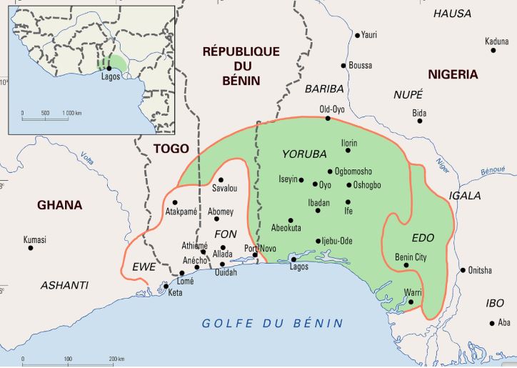
Aujourd’hui ville d’un demi-million d’habitants au sud-ouest du Nigeria, Ifè fut le centre religieux et l’ancienne capitale du peuple yoruba qui s’est développé pour l’essentiel grâce au commerce qu’il faisait sur le fleuve Niger, long de 4200 km, avec les peuples de l’Afrique de l’Ouest et au-delà.
Cet espace avant tout géoculturel de quelque 55 millions de personnes a prospéré dans une vaste ère géographique (Yoruba-land) d’environ 142 000 km², comprenant des régions entières de pays comme le Nigeria (76 %), le Bénin (18,9 %) et le Togo (6,5 %) actuels.
On trouve également des Yoruba au Ghana, au Burkina Faso, en Côte d’Ivoire et, depuis la traite négrière, aux Etats-Unis. Ce n’est donc pas surprenant que le yuroba, une langue à tons, soit l’une des trois grandes langues du Nigeria, également parlée dans certaines régions du Bénin et du Togo, ainsi qu’aux Antilles et en Amérique latine, notamment à Cuba par les descendants d’esclaves africains. Espace géo-culturel des yoruba autour d’Ifè et, à droite, celui du peuple edo au Royaume autour de Bénin City.
Un trésor hors du commun
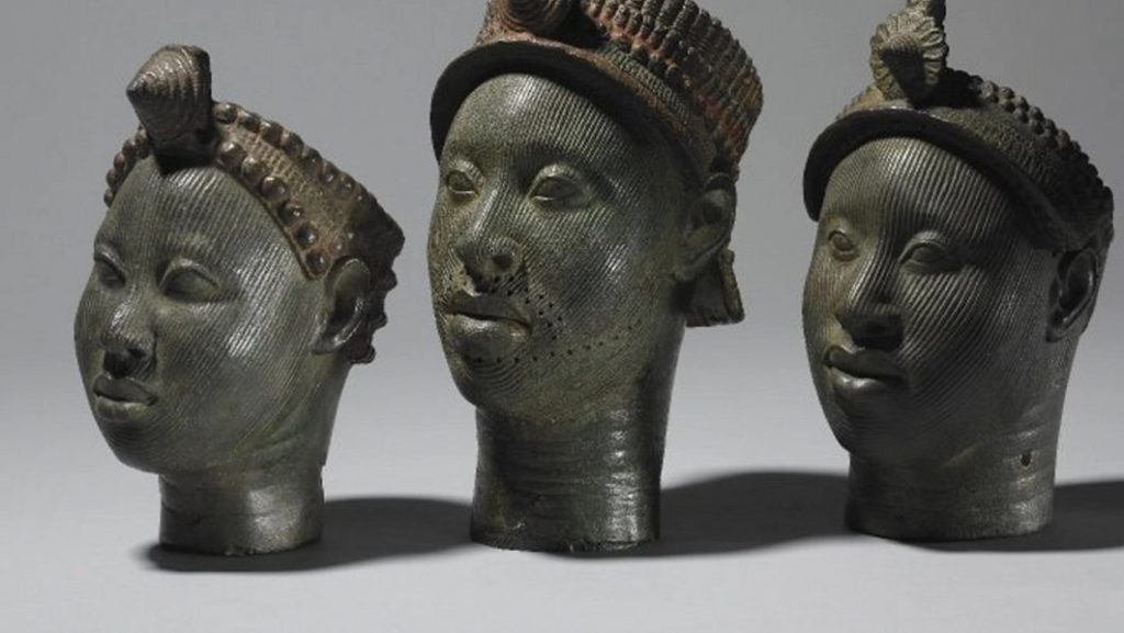
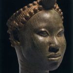
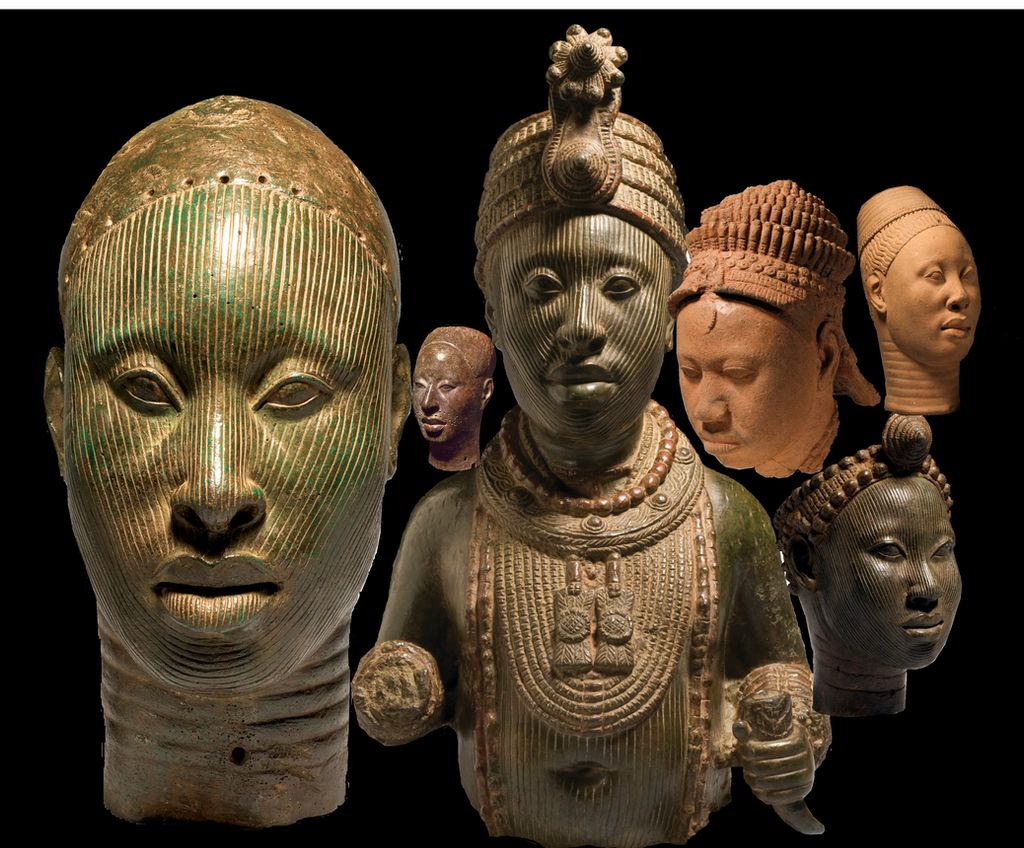
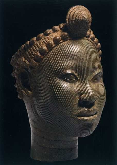
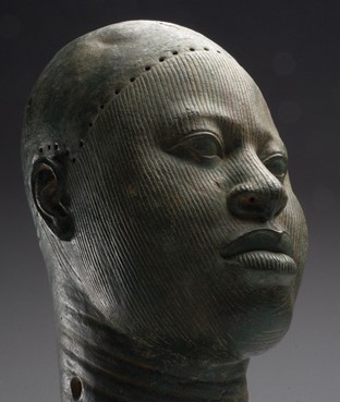
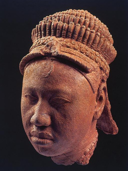
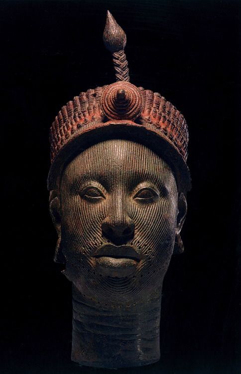
C’est en janvier 1938, lors de travaux de terrassement pour la construction d’une maison, que des ouvriers découvrent à Ifè, dans le quartier de Wunmonije, un trésor peu ordinaire. A une centaine de mètres du site du Palais Royal, ils déterrent treize magnifiques têtes en bronze datant du XIIe siècle représentant un roi (un « Ooni ») et des courtisans. D’autres ont été déterrées depuis.
Leurs visages, hormis les lèvres, sont couverts de striures. La coiffure fait penser à une couronne complexe composée de plusieurs couches de billes tubulaires, surmontée d’une crête avec une rosette et une « aigrette ».
La surface de cette couronne porte des traces de peinture rouge et noire. Ces grandes têtes ont pu servir d’effigies de défunts lors de cérémonies funéraires, qui, chez les Yoruba, ont parfois lieu un an après l’enterrement rapide des morts qu’impose le climat tropical.
Le rendu très ressemblant et naturaliste des têtes est alors considéré comme anachronique dans l’art de l’Afrique subsaharienne, et encore plus troublant que celui des portraits de momie, très réalistes, du Fayoum égyptien (I-IIe siècle)..
Pourtant, une longue tradition de sculpture figurative présentant des caractéristiques semblables existait avant la création de ces sculptures de métal, en particulier chez les Nok, un peuple de cultivateurs maîtrisant le fer à partir de 800 ans avant notre ère.
Hystérie
Depuis 1938, les « têtes d’Ifè » ont provoqué des réactions proches de l’hystérie en Europe et en Occident.
D’un côté, les « modernistes » et les « abstraits » du début du XXe siècle, pour qui plus une sculpture est abstraite et s’éloigne de la réalité, plus elle est considérée comme typiquement africaine.
Pour ceux qui s’inspiraient de « l’abstrait » africain pour se libérer du naturalisme matérialiste, les têtes d’Ifè venaient donc brutalement bousculer leurs théories savamment construites.
De l’autre, surtout pour les partisans de l’impérialisme colonial, cet art ne pouvait tout simplement pas exister.
A Frank Willett, le responsable du Département nigérian des Antiquités et auteur d’Ifè, une civilisation africaine (Editions Tallandier, 1967), qui rapportait que « les Européens en visite à Ifè se demandent fréquemment comment des gens vivant dans des maisons de boue séchée, aux toits de paille, ont pu fabriquer d’aussi beaux objets que les bronzes et terres cuites au musée », l’éditeur Sir Mortimer Wheeler répondit :
Le préjugé a la vie dure, qui veut que la création et la sensibilité artistiques ne puissent exister sans les talents domestiques et le confort sanitaire !
Les interrogations des Européens étaient nombreuses. Comment, au XIIe siècle, des peuples primitifs, n’ayant jamais connu de forme d’État organisé, auraient-ils pu fabriquer des têtes en bronze d’un tel raffinement, faisant appel à des techniques que même l’Europe ne maîtrisait pas à cette époque ? Comment des tribus, vivant dans la superstition et la magie la plus irrationnelle, auraient-elles pu observer avec tant de minutie l’anatomie humaine ? Comment des sauvages auraient-ils pu exprimer des sentiments aussi nobles, aussi bien envers des hommes que des femmes ?

Devant un paradoxe aussi insoutenable, le déni fut la règle.
Ainsi, lorsque l’archéologue allemand Leo Frobenius présenta le premier ce type de tête, les experts refusèrent de croire à l’existence d’une civilisation africaine capable de laisser des artefacts d’une qualité qu’ils reconnaissaient comparable aux meilleures réalisations artistiques de la Rome ou de la Grèce antiques. Pour tenter d’expliquer ce qui passait pour une anomalie, Frobenius avança alors, sans le moindre début de preuve, la théorie que ces têtes auraient été moulées par une colonie grecque fondée au XIIIe siècle av. J.-C., et que cette dernière pouvait être à l’origine de la vieille légende de la civilisation perdue de l’Atlantide, un récit repris en chœur par la presse populaire…
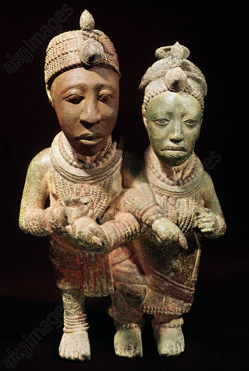
Bronze
Ce qui choqua en premier lieu les experts occidentaux, c’est qu’il s’agissait de têtes en bronze, en réalité en laiton au plomb (environ 70 % de cuivre, 16,5 % de zinc et 11,3 % de plomb).
Etant donné la rareté de ce minerai au Nigeria, ces objets démontrent que la région entretenait des relations commerciales avec des pays lointains. On pense qu’il provenait de l’Europe centrale, du nord-ouest de la Mauritanie, de l’Empire byzantin ou, via le fleuve Niger, de Tombouctou, où le minerai arrivait, à dos de dromadaire, du sud du Maroc.
Si durant la période du Néolithique, des pépites de cuivre, d’or et d’argent sont martelés à froid ou à chaud, ce n’est qu’à partir de l’Age du bronze que l’homme découvre la métallurgie. A partir de minerais, il est alors capable d’extraire des métaux grâce à un traitement thermique précis, rendu possible par l’expérience des céramistes de l’époque, grands experts dans la maîtrise de la chaleur et des fours de cuisson.
Or, le cuivre ne fond qu’à 1083° Celsius, mais en y ajoutant de l’étain (qui fond à 232°) et du plomb (qui fond à 327°), on peut obtenir du bronze à 890° et du laiton à 900°. La terre cuite se fait, elle, à basse température, aux alentours de 600 à 800°.
Cependant, en Chine, dès la dynastie des Shang (1570 – 1045 av. JC), certaines porcelaines exigent des températures beaucoup plus élevées, entre 1000 et 1300°.
Les plus anciennes traces de céramique en Afrique subsaharienne semblent dater de plus de 9000 av. J.-C., voire plus encore, quelques tessons fragmentaires, datés de 12 000 av. J.-C. ayant été découverts en Afrique de l’Ouest, en l’occurrence au Mali.
La céramique se manifeste également plus au sud, notamment avec la culture Nok dans le nord du Nigeria au début du Premier millénaire av. JC.
Cire perdue
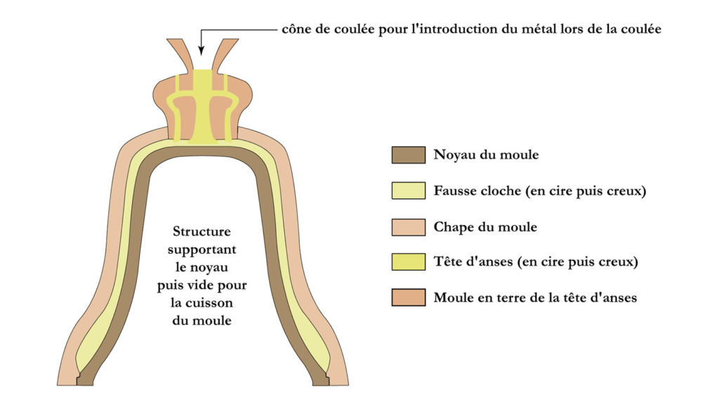
Ensuite, ce qui choqua tout autant les experts, c’est que la technique mise en œuvre pour leur réalisation était la technique dite « à cire perdue », un procédé de moulage de précision qu’on utilise encore de nos jours pour la fabrication des cloches d’églises. Le moule se compose de trois parties distinctes et superposées : le noyau, la cloche ou la statue (en cire) et la « carapace » ou chape. Par différentes astuces, le bronze en fusion qu’on laisse pénétrer va se substituer au modèle en cire. Lors de la coulée, différents conduits doivent permettre d’évacuer aussi bien la fumée qu’une partie de la cire lorsqu’elle fond.
En clair, il faut des artisans très qualifiés pour exercer le métier de fondeur de bronze professionnel.
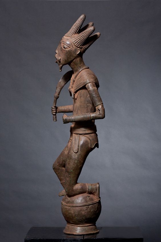
Le savoir-faire exceptionnel des fondeurs d’Ifè fut précédé de peu par ceux d’Igbo-Ukwu au Nigeria oriental où l’on découvrit en 1939 un tombeau plein d’objets d’art datant du IXe siècle révélant l’existence d’un royaume puissant et raffiné maîtrisant la fameuse technique à la cire perdue, mais qui ne peut être rattachée à aucune autre culture de la région.
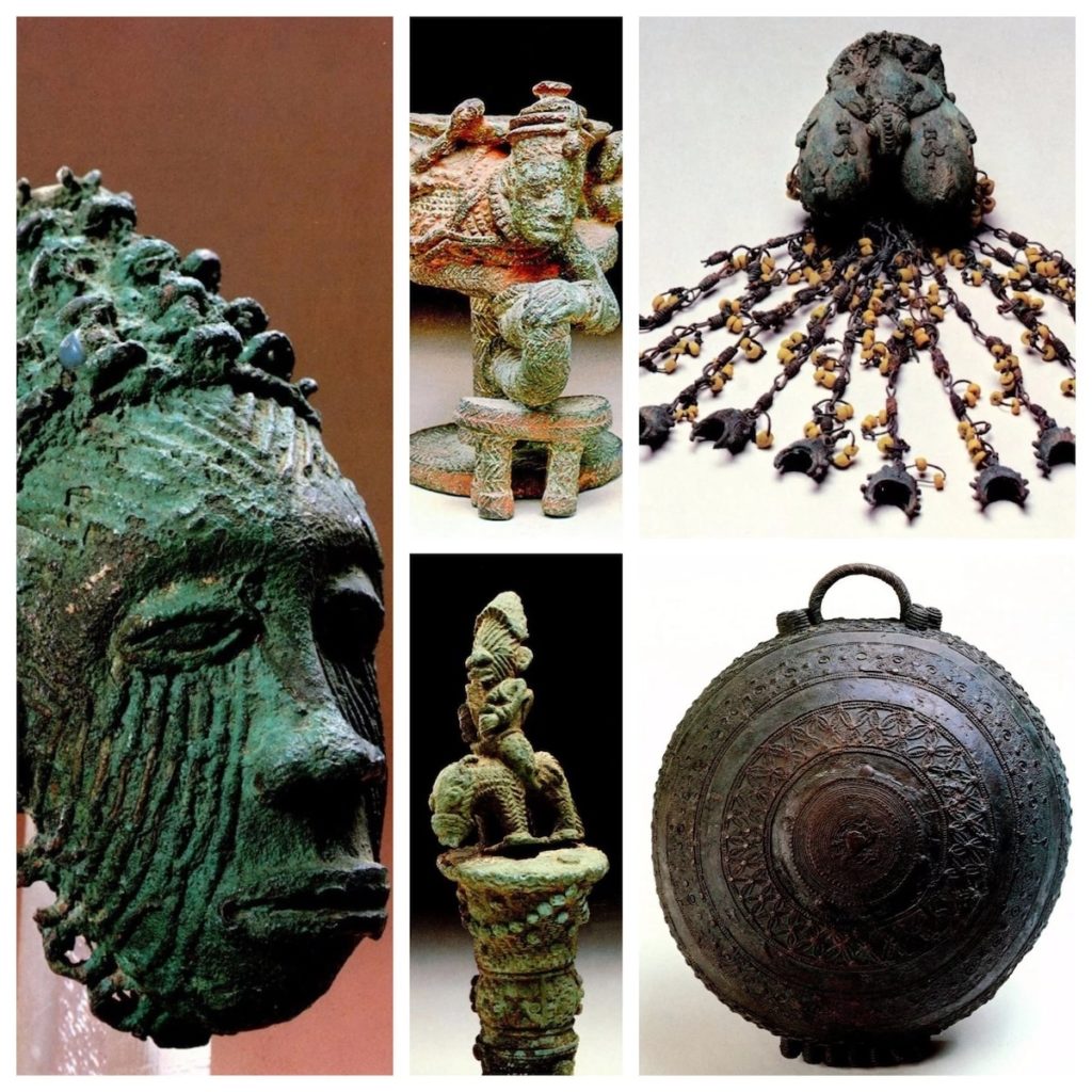
Historiquement, l’amulette de Mehrgarh au Pakistan, âgée de 6000 ans, est le premier objet connu façonné à la cire perdue. Si la Chine, la Grèce et Rome maîtrisent cette technique, il faut attendre la Renaissance pour qu’elle fasse son retour en Europe.
Ifè, un Etat organisé
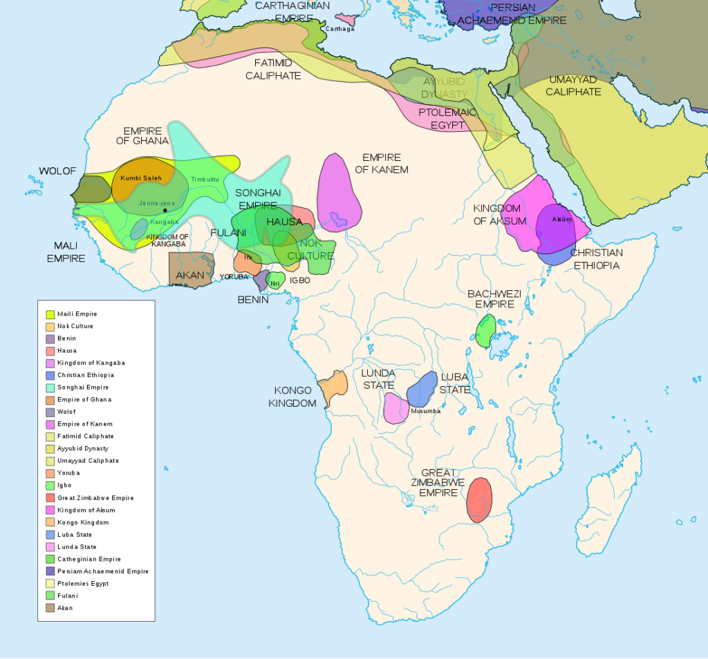
Cartes des différents royaumes et empires africains avant la colonisation. Terre cuite en provenance du site d’Ita Yemoo, Ifè, Nigeria (XIIe au XIVe siècle).
En réalité, l’art d’Ifè mettait à mal la théorie coloniale pour qui l’Afrique n’était qu’un terrain vierge, peuplé d’animaux et de quelques peuplades primitives n’ayant jamais fait leurs premiers pas dans « l’histoire ».
En effet, toute preuve démontrant sur le continent africain l’existence d’empires, de royaumes ou de grands Etats ayant permis aux Africains de s’autogouverner de façon pacifique pendant des siècles, ne pouvait que délégitimer la « mission civilisatrice » du colonialisme.
Or, selon la tradition orale, Ifè fut fondée aux IXe-Xe siècles par Oduduwa, par le regroupement de 13 villages en une cité qui sera la ville centrale de la mythologie yoruba, pour qui elle est le berceau de l’humanité et le centre du monde.
Reconnu comme un dieu mineur, Oduduwa devint ainsi le premier Ooni (Roi) et se fit construire un Aafin (palais). Il gouverna à l’aide des isoro, anciens chefs de village ayant récupéré un titre religieux et assujettis à l’autorité politique royale.
Toujours selon les traditions orales, Oduduwa serait un prince exilé d’un peuple étranger, ayant quitté sa patrie avec une suite et voyagé en direction du sud, s’installant parmi les Yoruba vers le XIIe siècle. Sa foi, qu’il aura apportée, était si importante pour ses disciples et lui qu’elle aurait été la cause de leur exode en premier lieu.
La terre ou le pays d’origine d’Oduduwa sont sujet à débat. Pour les uns, il vient de La Mecque, pour les autres, d’Egypte, comme les savoir-faire qu’il apporta sont supposés le démontrer.
Il est vrai qu’on s’est avant tout intéressé aux routes conduisant vers la mer et les fleuves, il ne fait pas de doute que la savane, au cours des siècles précédents, a pu relier le delta du Niger au Nil, telle une sorte de grande route transcontinentale, passant notamment par le Tchad où des milliers de peintures pariétales témoignent d’un sens artistique créateur.
Le peuple Edo de Bénin City croit, quant à lui, qu’Oduduwa était en fait un prince de chez eux. Il aurait quitté le Bénin à cause d’une lutte pour la succession royale. C’est pourquoi l’un de ses descendants, le prince Oramiyan, fut par la suite autorisé à revenir, et fonda la dynastie qui régna sur le Royaume du Bénin. Le prince Oramiyan fut donc le premier oba du Benin, remplaçant ainsi avec succès le système monarchique Ogiso qui régnait jusque-là.
Métallurgie
Ce qui mérite l’attention, c’est que la métallurgie occupe une place centrale à Ifè. Oduduwa possédait une forge dans son palais (Ogun Laadin). Les rois des différents royaumes installaient leurs forges dans l’enceinte du palais royal, montrant ainsi le rapport symbolique fort entre pouvoir et métallurgie.
Les plus anciennes traces documentant la transformation du minerai de fer en Afrique remontent au IIIe millénaire av. JC. Il s’agit des sites archéologiques d’Egaro au Niger oriental et de Gizeh et Abydos en Egypte.
Tandis que le site de Buhen en Nubie égyptienne (- 1991), après avoir travaillé le fer, deviendra une « usine à cuivre », les sites d’Oliga au Cameroun (-1300) et de Nok au Nigeria (-925) témoignent d’une activité métallurgique dynamique.
Contrairement à ce qui s’est passé sur d’autres continents, l’Age de fer en Afrique aurait précédé dans certaines régions celui du cuivre. Comme nous l’avons vu, les techniques de production du laiton montrent un savoir-faire technologique très avancé. Ifè sera également un centre majeur de production verrière, en particulier de perles de verre. Les déchets de cette production ancestrale, constitués de parties de creusets recouverts de verre fondu, seront recherchés au XIXe siècle par les habitants de la région, bien que l’origine en soit à l’époque oubliée.
Des fouilles archéologiques récentes ont démontré que le peuplement de cette aire est très ancien. Mais comme nous l’avons vu, ce n’est qu’au début du IIe millénaire que des évolutions dans le domaine de la métallurgie auraient permis d’améliorer les outils agricoles et de générer des excédents de nourriture. On y cultive l’igname, le manioc, le maïs et le coton, qui est aussi à la source d’une importante industrie de tissage de vêtements.

La ville connaîtra ainsi une expansion démographique rapide grâce à cet essor de la productivité agricole, dû à la maîtrise d’une densité énergétique accrue permettant de transformer des « pierres » en ressources utiles.
L’urbanisation médiévale d’Ifè est aujourd’hui largement attestée par l’existence de nombreuses enceintes faites de fossés et de talus, qui semblent indiquer les différents espaces ayant connu une concentration démographique et une entité politique suffisamment puissante pour mettre en œuvre de tels travaux.
Ainsi, en tant qu’Etat centralisé, Ifè s’érige très tôt en modèle pour d’autres Etats dans la région et au-delà. Plusieurs descendants et capitaines d’Oduduwa ont fondé d’autres royaumes sur le même modèle et s’appuyant sur la même légitimité. L’expérience monarchique d’Ifè s’exporte avec son cadre culturel. L’adé ilèkè, une couronne de perles de verre symbolisant le pouvoir royal, se retrouve dans la plupart des monarchies de la région.
En tout, de 7 à 20 royaumes selon les sources composent le monde yoruba dans la première moitié du deuxième millénaire de notre ère.
- L’État d’Oyo au Nigeria fut l’une des plus puissantes cités-États yoruba.
- Autre exemple, le Royaume de Kétou, actuellement au sud-est du Bénin, aurait été fondé vers le XIVe siècle par un prétendu descendant d’Oduduwa. Il aurait quitté Ifè avec sa famille et d’autres membres de son clan, pour se diriger vers l’ouest, avant de s’installer finalement dans la cité d’Aro, au nord-est de la ville de Kétou. Rapidement, Aro devint trop petit pour la population grandissante du clan, et la décision fut prise de s’installer à Kétou. Le roi Ede quitta donc Aro avec 120 familles et s’installa dans cette ville.
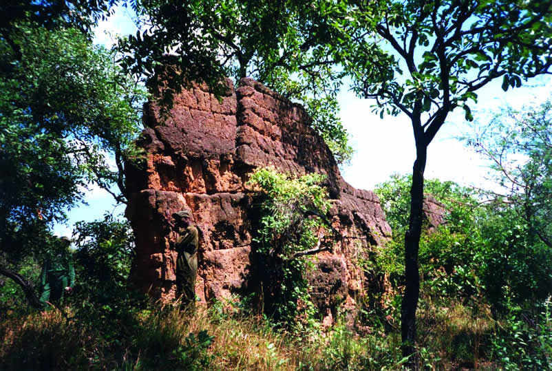
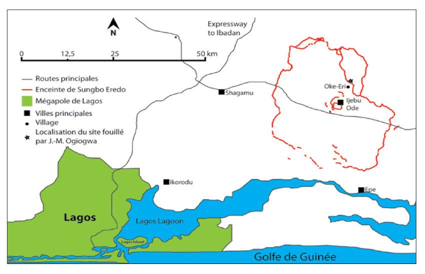
- Autre démonstration des bâtisseurs yoruba, près de la capitale nigeriane Lagos, l’enceinte de Sungbo Eredo, un système de murailles et de fossés construit au XIVe siècle e situé au sud-ouest de la ville d’Ijebu Ode, dans l’État d’Ogun, au sud-ouest du Nigeria. Sur plus de 160 km de long, ces fortifications, parfois hautes de 20 mètres, consistent en un fossé aux parois lisses, formant une douve intérieure par rapport aux murs qui le surplombent. Le fossé forme un anneau irrégulier autour des terres de l’ancien royaume d’Ijebu. Cet anneau fait environ 40 km dans le sens nord-sud et 35 km dans le sens est-ouest, c’est-à-dire l’équivalent du boulevard périphérique parisien ! Envahi par la végétation, l’édifice ressemble aujourd’hui à un tunnel verdoyant.
D’Ifè au Royaume du Bénin
Au XIVe siècle, Ifè connaît un effondrement démographique, caractérisé par l’abandon de certaines enceintes et une forte avancée de la forêt dans des zones anciennement occupées. On constate également une rupture dans les savoir-faire et les techniques artisanales. Cet effondrement démographique pourrait s’expliquer par une épidémie de peste noire, selon certains auteurs, qui font un parallèle avec les grandes épidémies constatées en Europe sur des périodes proches.
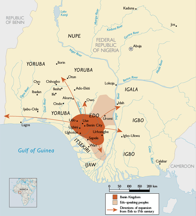
Une partie des habitants a pu se réfugier et apporter son savoir-faire en métallurgie au Royaume du Bénin, qui dura du XIIe siècle jusqu’à son invasion par l’Empire britannique à la fin du XIXe siècle. Il s’agit d’un Etat d’Afrique de l’Ouest côtière dominé par les Edos, une ethnie dont la dynastie survit encore aujourd’hui. Son territoire correspond au Bénin actuel, plus une partie du Togo et le sud-ouest de l’actuel Nigeria, où se trouve d’ailleurs aujourd’hui « Bénin City », un port historique sur le fleuve Bénin. Au cœur de la cité, la résidence royale aux proportions monumentales traduit dans l’espace l’importance accordée au pouvoir politique, spirituel et traditionnel.
Bénin City, une merveille
L’organisation sociale de la ville impressionne les visiteurs européens à la fin du XVe siècle. Important pôle économique régional, on y trouve de l’ivoire, du poivre et des esclaves. Les Européens y échangent de l’huile de palme (le palmier à huile poussant abondamment dans la région) contre des fusils, permettant la modernisation de l’armement béninois.
Située dans une plaine, Bénin City est entourée de murs massifs au sud et de profonds fossés au nord. Au-delà des murs de la ville, de nombreuses autres murailles ont été érigées qui séparent les environs de la capitale en quelque 500 villages distincts.
En 2016, un article du Guardian retraçait la splendeur de la ville. Le journal rapporte que le livre des records Guinness de 1974 décrit les murs de Bénin City comme les plus grands travaux de terrassement au monde réalisés avant l’ère mécanique. Selon les estimations de Fred Pearce, du New Scientist, les murs de Bénin City étaient à un moment donné « quatre fois plus longs que la Grande Muraille de Chine et employaient cent fois plus de matériaux que la Grande Pyramide de Khéops ».
Pearce précise que ces murs « s’étendaient sur quelque 16 000 km en tout, dans une mosaïque de plus de 500 limites de colonies interconnectées. Ils couvraient 6500 km2 et ont tous été creusés par le peuple Edo… On estime qu’il a fallu 150 millions d’heures pour les construire et qu’ils constituent peut-être le plus grand phénomène archéologique de la planète ».
Bénin City fut également l’une des premières villes à s’équiper d’un semblant d’éclairage public. D’énormes lampes métalliques, hautes de plusieurs mètres, se dressaient autour de la ville, en particulier près du palais du roi. Alimentées par de l’huile de palme, leurs mèches brûlaient pendant la nuit pour éclairer la circulation à destination et en provenance du palais.
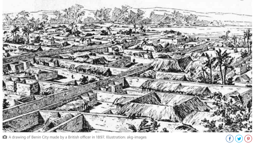
Lorsque les Portugais découvrirent la ville pour la première fois en 1485, ils furent stupéfaits de trouver ce vaste royaume, fait de centaines de villes et de villages imbriqués les uns dans les autres au milieu de la jungle africaine. Ils l’appelèrent la « Grande ville du Bénin », à une époque où il n’y avait aucun autre endroit en Afrique que les Européens reconnaissent comme une ville. Ils la classèrent comme l’une des villes les plus belles et les mieux aménagées du monde. Bénin City en 1686.
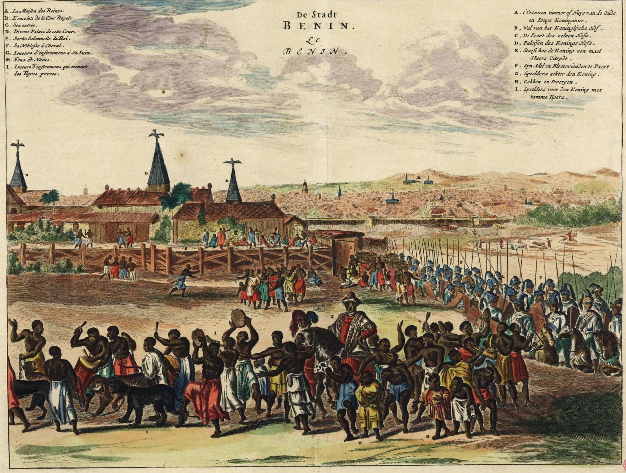
En 1691, le capitaine de navire portugais Lourenco Pinto constatait :
Le Grand Bénin, où réside le roi, est plus grand que Lisbonne ; toutes les rues sont droites et à perte de vue. Les maisons sont grandes, en particulier celle du roi, qui est richement décorée et possède de belles colonnes. La ville est riche et industrieuse. Elle est si bien gouvernée que le vol est inconnu et les gens vivent dans une telle sécurité qu’ils n’ont pas de portes pour leurs maisons.
En revanche, à la même époque, Londres est décrite par Bruce Holsinger, professeur d’anglais à l’université de Virginie, comme une ville
de vol, prostitution, meurtre, corruption et marché noir florissant, ce qui a rendu la ville médiévale mûre pour l’exploitation par ceux qui savent manier la lame rapide ou faire les poches.
Les fractales africaines
La planification et la conception de Bénin City ont été faites selon des règles précises de symétrie, de proportionnalité et de répétition, aujourd’hui connues sous le nom de « fractales ».
Le mathématicien Ron Eglash, auteur de African Fractals (qui traite des motifs sous-tendant l’architecture, l’art et le design dans de nombreuses régions d’Afrique), note que la ville et les villages environnants ont été délibérément aménagés pour former des fractales parfaites, avec des formes similaires répétées dans les pièces de chaque maison, la maison elle-même et les groupes de maisons du village selon des motifs mathématiquement prévisibles.
Lorsque les Européens arrivèrent en Afrique, précise-t-il, ils considéraient l’architecture comme très désorganisée et donc primitive. Il ne leur est jamais venu à l’esprit que les Africains pouvaient utiliser une forme de mathématiques qu’eux-mêmes n’avaient pas encore découverte.
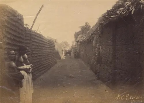
Au centre de la ville se trouvait le Palais royal, entouré d’une trentaine de rues droites et larges chacune d’environ 120 pieds. Ces rues principales, perpendiculaires les unes par rapport aux autres, étaient dotées d’un drainage souterrain constitué d’un impluvium, avec une sortie pour évacuer les eaux d’orage. De nombreuses rues plus étroites et se croisant s’étendaient à l’extérieur. Au milieu des rues, il y avait du gazon que les animaux pouvaient paître.
Les maisons sont construites le long des rues en bon ordre, l’une à côté de l’autre, écrit Olfert Dapper, visiteur hollandais du XVIIe siècle. Elles sont généralement larges, avec de longues galeries à l’intérieur, surtout dans le cas des maisons de la noblesse, et divisées en de nombreuses pièces qui sont séparées par des murs en argile rouge, très bien érigés.
Dapper ajoute que les riches résidents ont gardé ces murs
aussi brillants et lisses en les lavant et en les frottant que n’importe quel mur en Hollande fait avec de la craie, et ils sont comme des miroirs. Les étages supérieurs sont faits de la même sorte d’argile. De plus, chaque maison est équipée d’un puits pour l’approvisionnement en eau douce.
Les maisons familiales sont divisées en trois parties : la partie centrale est le quartier du mari, qui donne sur la route ; à gauche le quartier des femmes (oderie), et à droite le quartier des jeunes hommes (yekogbe).
La vie quotidienne à Bénin City voyait peut-être se déplacer dans des rues encore plus grandes, des foules constituées de gens vêtus de couleurs vives, certains en blanc, d’autres en jaune, bleu ou vert, les capitaines de la ville jouant le rôle de juges dans les procès, modérant les débats dans les nombreuses galeries et arbitrant les petits conflits sur les marchés.
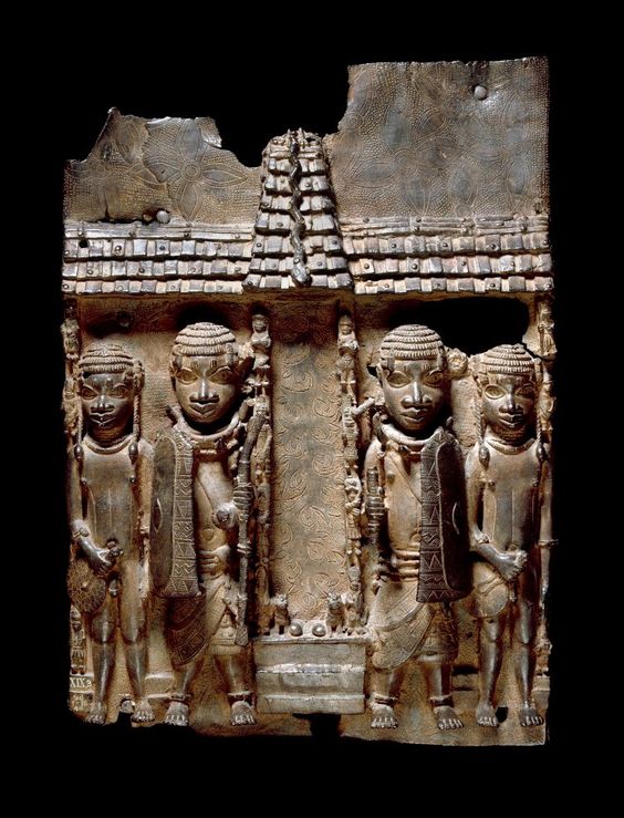
Les premiers explorateurs étrangers décrivent Benin City comme un lieu exempt de criminalité et de faim, avec de grandes rues et des maisons propres, une ville remplie de gens courtois et honnêtes, et gérée par une bureaucratie centralisée et très sophistiquée. Bénin : plaque en laiton (bronze) montrant l’entrée du Palais royal où d’autres plaques décorent les piliers.

La ville est divisée en 11 arrondissements, chacune étant une réplique en plus petit de la cour du roi, comprenant une série tentaculaire de complexes incluant des logements, des ateliers et des bâtiments publics – reliés entre eux par d’innombrables portes et passages, tous richement décorés avec l’art qui a rendu le Bénin célèbre. La ville en était littéralement recouverte.
Les murs extérieurs des cours et les faîtes des enceintes sont décorés de motifs horizontaux (agben) et de sculptures en argile représentant des animaux, des guerriers et d’autres symboles de pouvoir.
Les sculptures sont conçues pour créer des motifs contrastés sous le fort soleil. Des objets naturels (galets ou morceaux de silicium) sont également pressés dans l’argile humide, tandis que dans les palais, les piliers sont recouverts de plaques de bronze illustrant les victoires et les exploits des anciens rois et nobles.
À l’apogée de sa grandeur, au XIIe siècle (bien avant le début de la Renaissance européenne), les rois et les nobles de Bénin City ont accordé leur mécénat aux artisans et les ont comblés de cadeaux et de richesses, en échange de la représentation des grands exploits des rois et des dignitaires dans des sculptures en bronze complexes.
Ces œuvres du Bénin sont à la hauteur des plus beaux exemples de la technique de fonte européenne », écrit Felix von Luschan, ancien professeur au Musée d’ethnologie de Berlin. « [Le sculpteur et fondeur italien] Benvenuto Celini n’aurait pas pu mieux les couler, ni personne d’autre avant ou après lui. Techniquement, ces bronzes représentent la plus haute réalisation possible.
La rencontre avec « la civilisation »
Suite à la conférence de Berlin de 1885 où Britanniques, Français, Allemands et autres puissances européennes se partagent, au nom des lois immuables de la géopolitique germano-britannique, l’Afrique comme un gros gâteau qu’il entendent dévorer, les invasions européennes se multiplient et gagnent en brutalité.
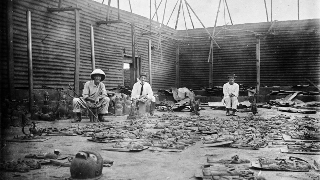
Ainsi, suite au refus du roi de céder aux Britanniques son monopole sur la production de l’huile de palme et d’autres productions, lors d’une expédition punitive en 1897, Bénin City est pillée, incendiée et réduite en cendres par les Britanniques. Le roi (l’oba) est chassé et plusieurs milliers de « bronzes du Bénin », certes moins réalistes que ceux d’Ifè, sont dispersés et en partie perdus.
Ils finissent par se retrouver sur le marché de l’art et aboutissent dans des musées, notamment au British Museum (700 objets) et au Musée d’ethnologie de Berlin (500 pièces). Le gouvernement britannique lui-même en vend une partie « pour couvrir les frais de l’expédition ». Comme quoi les uns entrent dans l’histoire avec leur art, les autres avec leurs crimes. Expédition punitive de 1897. Une fois le palais royal brûlé, les pilleurs britanniques alignent les pièces en cuivre et en laiton qu’ils ramèneront en Europe.
Bibliographie sommaire :
- Ifè, une civilisation africaine, Frank Willett, Jardin des Arts/Tallandier, Paris 1971 ;
- Histoire générale de l’Afrique, Présence africaines/Edicef/Unesco, Paris 1987 ;
- Atlas historique de l’Afrique, Editions du Jaguar, Paris 1988 ;
- L’Afrique ancienne, de l’Acus au Zimbabwe, sous la direction de François-Xavier Fauvelle, Belin/Humensis, Paris 2018.